 Note:
The expiration time in the watch graphic is amended if the watch is
replaced, cancelled or extended.
Note:
Note:
The expiration time in the watch graphic is amended if the watch is
replaced, cancelled or extended.
Note: Click for
Watch Status Reports.
SEL6
URGENT - IMMEDIATE BROADCAST REQUESTED
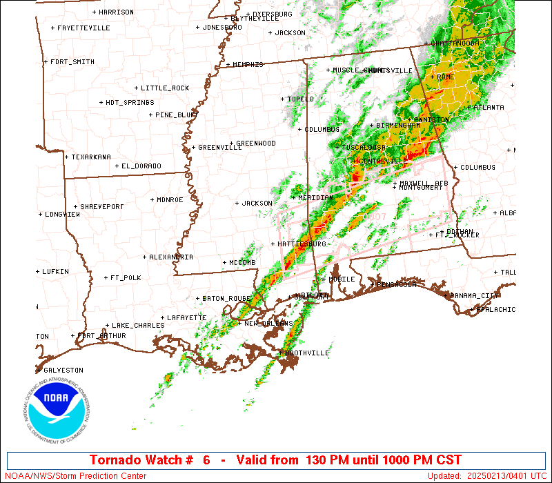
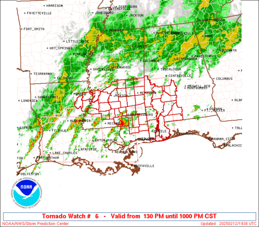
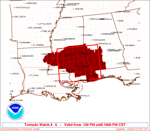
Tornado Watch Number 6
NWS Storm Prediction Center Norman OK
130 PM CST Wed Feb 12 2025
The NWS Storm Prediction Center has issued a
* Tornado Watch for portions of
Southwest Alabama
Eastern Louisiana
Southern and South-Central Mississippi
Coastal Waters
* Effective this Wednesday afternoon and evening from 130 PM
until 1000 PM CST.
* Primary threats include...
A few tornadoes and a couple intense tornadoes likely
Scattered damaging winds likely with isolated significant gusts
to 75 mph possible
SUMMARY...Conditions favorable for rotating storms capable of
tornadoes and damaging winds will increasingly expand
north-northeastward across the region through the afternoon and
early evening.
The tornado watch area is approximately along and 85 statute miles
north and south of a line from 30 miles north northwest of Mc Comb
MS to 90 miles northeast of Mobile AL. For a complete depiction of
the watch see the associated watch outline update (WOUS64 KWNS
WOU6).
PRECAUTIONARY/PREPAREDNESS ACTIONS...
REMEMBER...A Tornado Watch means conditions are favorable for
tornadoes and severe thunderstorms in and close to the watch
area. Persons in these areas should be on the lookout for
threatening weather conditions and listen for later statements
and possible warnings.
&&
OTHER WATCH INFORMATION...CONTINUE...WW 5...
AVIATION...Tornadoes and a few severe thunderstorms with hail
surface and aloft to 1.5 inches. Extreme turbulence and surface wind
gusts to 65 knots. A few cumulonimbi with maximum tops to 500. Mean
storm motion vector 22035.
...Guyer
 Note:
The Aviation Watch (SAW) product is an approximation to the watch area.
The actual watch is depicted by the shaded areas.
Note:
The Aviation Watch (SAW) product is an approximation to the watch area.
The actual watch is depicted by the shaded areas.
   SAW6
   WW 6 TORNADO AL LA MS CW 121930Z - 130400Z
   AXIS..85 STATUTE MILES NORTH AND SOUTH OF LINE..
   30NNW MCB/MC COMB MS/ - 90NE MOB/MOBILE AL/
   ..AVIATION COORDS.. 75NM N/S /27NW MCB - 52NNW CEW/
   HAIL SURFACE AND ALOFT..1.5 INCHES. WIND GUSTS..65 KNOTS.
   MAX TOPS TO 500. MEAN STORM MOTION VECTOR 22035.

   LAT...LON 32819067 32838717 30378717 30359067

   THIS IS AN APPROXIMATION TO THE WATCH AREA.  FOR A
   COMPLETE DEPICTION OF THE WATCH SEE WOUS64 KWNS
   FOR WOU6.
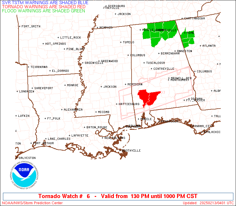
Watch 6 Status Report Messages:
STATUS REPORT #7 ON WW 6
VALID 130235Z - 130340Z
SEVERE WEATHER THREAT CONTINUES RIGHT OF A LINE FROM 40 NW MSY TO
30 ESE TCL.
..WEINMAN..02/13/25
ATTN...WFO...MOB...BMX...JAN...
&&
STATUS REPORT FOR WT 6
SEVERE WEATHER THREAT CONTINUES FOR THE FOLLOWING AREAS
ALC003-023-025-035-047-053-091-097-099-129-131-130340-
AL
. ALABAMA COUNTIES INCLUDED ARE
BALDWIN CHOCTAW CLARKE
CONECUH DALLAS ESCAMBIA
MARENGO MOBILE MONROE
WASHINGTON WILCOX
$$
MSC035-039-041-067-073-111-131-153-130340-
MS
. MISSISSIPPI COUNTIES INCLUDED ARE
FORREST GEORGE GREENE
JONES LAMAR PERRY
STONE WAYNE
$$
GMZ630-631-632-130340-
CW
. ADJACENT COASTAL WATERS INCLUDED ARE
NORTH MOBILE BAY
SOUTH MOBILE BAY
MISSISSIPPI SOUND
$$
THE WATCH STATUS MESSAGE IS FOR GUIDANCE PURPOSES ONLY. PLEASE
REFER TO WATCH COUNTY NOTIFICATION STATEMENTS FOR OFFICIAL
INFORMATION ON COUNTIES...INDEPENDENT CITIES AND MARINE ZONES
CLEARED FROM SEVERE THUNDERSTORM AND TORNADO WATCHES.
$$
STATUS REPORT #6 ON WW 6
VALID 130150Z - 130240Z
SEVERE WEATHER THREAT CONTINUES RIGHT OF A LINE FROM 55 SSW MCB
TO 25 SW MEI TO 20 S TCL.
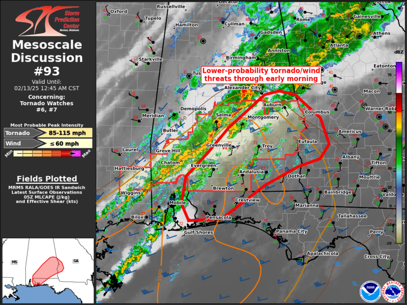
FOR ADDITIONAL INFORMATION SEE MESOSCALE DISCUSSION 91
..WEINMAN..02/13/25
ATTN...WFO...MOB...BMX...JAN...
&&
STATUS REPORT FOR WT 6
SEVERE WEATHER THREAT CONTINUES FOR THE FOLLOWING AREAS
ALC003-023-025-035-047-053-091-097-099-119-129-131-130240-
AL
. ALABAMA COUNTIES INCLUDED ARE
BALDWIN CHOCTAW CLARKE
CONECUH DALLAS ESCAMBIA
MARENGO MOBILE MONROE
SUMTER WASHINGTON WILCOX
$$
MSC023-031-035-039-041-061-065-067-073-091-111-131-153-130240-
MS
. MISSISSIPPI COUNTIES INCLUDED ARE
CLARKE COVINGTON FORREST
GEORGE GREENE JASPER
JEFFERSON DAVIS JONES LAMAR
MARION PERRY STONE
WAYNE
$$
GMZ630-631-632-130240-
CW
. ADJACENT COASTAL WATERS INCLUDED ARE
NORTH MOBILE BAY
SOUTH MOBILE BAY
MISSISSIPPI SOUND
$$
THE WATCH STATUS MESSAGE IS FOR GUIDANCE PURPOSES ONLY. PLEASE
REFER TO WATCH COUNTY NOTIFICATION STATEMENTS FOR OFFICIAL
INFORMATION ON COUNTIES...INDEPENDENT CITIES AND MARINE ZONES
CLEARED FROM SEVERE THUNDERSTORM AND TORNADO WATCHES.
$$
STATUS REPORT #5 ON WW 6
VALID 130040Z - 130140Z
SEVERE WEATHER THREAT CONTINUES RIGHT OF A LINE FROM 25 W MCB TO
40 WNW PIB TO 40 S CBM.
FOR ADDITIONAL INFORMATION SEE MESOSCALE DISCUSSION 90
..WEINMAN..02/13/25
ATTN...WFO...MOB...BMX...JAN...
&&
STATUS REPORT FOR WT 6
SEVERE WEATHER THREAT CONTINUES FOR THE FOLLOWING AREAS
ALC003-023-025-035-047-053-091-097-099-119-129-131-130140-
AL
. ALABAMA COUNTIES INCLUDED ARE
BALDWIN CHOCTAW CLARKE
CONECUH DALLAS ESCAMBIA
MARENGO MOBILE MONROE
SUMTER WASHINGTON WILCOX
$$
MSC023-031-035-039-041-061-065-067-069-073-075-077-091-101-111-
129-131-153-130140-
MS
. MISSISSIPPI COUNTIES INCLUDED ARE
CLARKE COVINGTON FORREST
GEORGE GREENE JASPER
JEFFERSON DAVIS JONES KEMPER
LAMAR LAUDERDALE LAWRENCE
MARION NEWTON PERRY
SMITH STONE WAYNE
$$
GMZ630-631-632-130140-
CW
. ADJACENT COASTAL WATERS INCLUDED ARE
NORTH MOBILE BAY
SOUTH MOBILE BAY
MISSISSIPPI SOUND
$$
THE WATCH STATUS MESSAGE IS FOR GUIDANCE PURPOSES ONLY. PLEASE
REFER TO WATCH COUNTY NOTIFICATION STATEMENTS FOR OFFICIAL
INFORMATION ON COUNTIES...INDEPENDENT CITIES AND MARINE ZONES
CLEARED FROM SEVERE THUNDERSTORM AND TORNADO WATCHES.
$$
STATUS REPORT #4 ON WW 6
VALID 122345Z - 130040Z
SEVERE WEATHER THREAT CONTINUES RIGHT OF A LINE FROM 25 ESE HEZ
TO 50 ESE GWO.
FOR ADDITIONAL INFORMATION SEE MESOSCALE DISCUSSION 90
..WEINMAN..02/12/25
ATTN...WFO...MOB...BMX...JAN...
&&
STATUS REPORT FOR WT 6
SEVERE WEATHER THREAT CONTINUES FOR THE FOLLOWING AREAS
ALC003-023-025-035-047-053-091-097-099-119-129-131-130040-
AL
. ALABAMA COUNTIES INCLUDED ARE
BALDWIN CHOCTAW CLARKE
CONECUH DALLAS ESCAMBIA
MARENGO MOBILE MONROE
SUMTER WASHINGTON WILCOX
$$
MSC023-029-031-035-039-041-061-065-067-069-073-075-077-079-085-
091-099-101-111-121-123-127-129-131-153-130040-
MS
. MISSISSIPPI COUNTIES INCLUDED ARE
CLARKE COPIAH COVINGTON
FORREST GEORGE GREENE
JASPER JEFFERSON DAVIS JONES
KEMPER LAMAR LAUDERDALE
LAWRENCE LEAKE LINCOLN
MARION NESHOBA NEWTON
PERRY RANKIN SCOTT
SIMPSON SMITH STONE
WAYNE
$$
GMZ630-631-632-130040-
CW
. ADJACENT COASTAL WATERS INCLUDED ARE
NORTH MOBILE BAY
SOUTH MOBILE BAY
MISSISSIPPI SOUND
$$
THE WATCH STATUS MESSAGE IS FOR GUIDANCE PURPOSES ONLY. PLEASE
REFER TO WATCH COUNTY NOTIFICATION STATEMENTS FOR OFFICIAL
INFORMATION ON COUNTIES...INDEPENDENT CITIES AND MARINE ZONES
CLEARED FROM SEVERE THUNDERSTORM AND TORNADO WATCHES.
$$
STATUS REPORT #3 ON WW 6
VALID 122250Z - 122340Z
SEVERE WEATHER THREAT CONTINUES RIGHT OF A LINE FROM 20 NNE HEZ
TO 35 SE GWO.
FOR ADDITIONAL INFORMATION SEE MESOSCALE DISCUSSION 88
..WEINMAN..02/12/25
ATTN...WFO...MOB...BMX...JAN...
&&
STATUS REPORT FOR WT 6
SEVERE WEATHER THREAT CONTINUES FOR THE FOLLOWING AREAS
ALC003-023-025-035-047-053-091-097-099-119-129-131-122340-
AL
. ALABAMA COUNTIES INCLUDED ARE
BALDWIN CHOCTAW CLARKE
CONECUH DALLAS ESCAMBIA
MARENGO MOBILE MONROE
SUMTER WASHINGTON WILCOX
$$
MSC023-029-031-035-039-041-049-061-063-065-067-069-073-075-077-
079-085-089-091-099-101-111-121-123-127-129-131-153-122340-
MS
. MISSISSIPPI COUNTIES INCLUDED ARE
CLARKE COPIAH COVINGTON
FORREST GEORGE GREENE
HINDS JASPER JEFFERSON
JEFFERSON DAVIS JONES KEMPER
LAMAR LAUDERDALE LAWRENCE
LEAKE LINCOLN MADISON
MARION NESHOBA NEWTON
PERRY RANKIN SCOTT
SIMPSON SMITH STONE
WAYNE
$$
GMZ630-631-632-122340-
CW
. ADJACENT COASTAL WATERS INCLUDED ARE
NORTH MOBILE BAY
SOUTH MOBILE BAY
MISSISSIPPI SOUND
$$
THE WATCH STATUS MESSAGE IS FOR GUIDANCE PURPOSES ONLY. PLEASE
REFER TO WATCH COUNTY NOTIFICATION STATEMENTS FOR OFFICIAL
INFORMATION ON COUNTIES...INDEPENDENT CITIES AND MARINE ZONES
CLEARED FROM SEVERE THUNDERSTORM AND TORNADO WATCHES.
$$
STATUS REPORT #2 ON WW 6
VALID 122150Z - 122240Z
SEVERE WEATHER THREAT CONTINUES RIGHT OF A LINE FROM 20 WNW HEZ
TO 45 NE MLU.
FOR ADDITIONAL INFORMATION SEE MESOSCALE DISCUSSION 88
..MOORE..02/12/25
ATTN...WFO...MOB...BMX...JAN...
&&
STATUS REPORT FOR WT 6
SEVERE WEATHER THREAT CONTINUES FOR THE FOLLOWING AREAS
ALC003-023-025-035-047-053-091-097-099-119-129-131-122240-
AL
. ALABAMA COUNTIES INCLUDED ARE
BALDWIN CHOCTAW CLARKE
CONECUH DALLAS ESCAMBIA
MARENGO MOBILE MONROE
SUMTER WASHINGTON WILCOX
$$
LAC065-107-122240-
LA
. LOUISIANA PARISHES INCLUDED ARE
MADISON TENSAS
$$
MSC021-023-029-031-035-039-041-049-061-063-065-067-069-073-075-
077-079-085-089-091-099-101-111-121-123-127-129-131-149-153-
122240-
MS
. MISSISSIPPI COUNTIES INCLUDED ARE
CLAIBORNE CLARKE COPIAH
COVINGTON FORREST GEORGE
GREENE HINDS JASPER
JEFFERSON JEFFERSON DAVIS JONES
KEMPER LAMAR LAUDERDALE
LAWRENCE LEAKE LINCOLN
MADISON MARION NESHOBA
NEWTON PERRY RANKIN
SCOTT SIMPSON SMITH
STONE WARREN WAYNE
$$
GMZ630-631-632-122240-
CW
. ADJACENT COASTAL WATERS INCLUDED ARE
NORTH MOBILE BAY
SOUTH MOBILE BAY
MISSISSIPPI SOUND
$$
THE WATCH STATUS MESSAGE IS FOR GUIDANCE PURPOSES ONLY. PLEASE
REFER TO WATCH COUNTY NOTIFICATION STATEMENTS FOR OFFICIAL
INFORMATION ON COUNTIES...INDEPENDENT CITIES AND MARINE ZONES
CLEARED FROM SEVERE THUNDERSTORM AND TORNADO WATCHES.
$$
STATUS REPORT #1 ON WW 6
VALID 122100Z - 122240Z
THE SEVERE WEATHER THREAT CONTINUES ACROSS THE ENTIRE WATCH AREA.
..MOORE..02/12/25
ATTN...WFO...MOB...BMX...JAN...
&&
STATUS REPORT FOR WT 6
SEVERE WEATHER THREAT CONTINUES FOR THE FOLLOWING AREAS
ALC003-023-025-035-047-053-091-097-099-119-129-131-122240-
AL
. ALABAMA COUNTIES INCLUDED ARE
BALDWIN CHOCTAW CLARKE
CONECUH DALLAS ESCAMBIA
MARENGO MOBILE MONROE
SUMTER WASHINGTON WILCOX
$$
LAC041-065-107-122240-
LA
. LOUISIANA PARISHES INCLUDED ARE
FRANKLIN MADISON TENSAS
$$
MSC021-023-029-031-035-039-041-049-061-063-065-067-069-073-075-
077-079-085-089-091-099-101-111-121-123-127-129-131-149-153-
122240-
MS
. MISSISSIPPI COUNTIES INCLUDED ARE
CLAIBORNE CLARKE COPIAH
COVINGTON FORREST GEORGE
GREENE HINDS JASPER
JEFFERSON JEFFERSON DAVIS JONES
KEMPER LAMAR LAUDERDALE
LAWRENCE LEAKE LINCOLN
MADISON MARION NESHOBA
NEWTON PERRY RANKIN
SCOTT SIMPSON SMITH
STONE WARREN WAYNE
$$
GMZ630-631-632-122240-
CW
. ADJACENT COASTAL WATERS INCLUDED ARE
NORTH MOBILE BAY
SOUTH MOBILE BAY
MISSISSIPPI SOUND
$$
THE WATCH STATUS MESSAGE IS FOR GUIDANCE PURPOSES ONLY. PLEASE
REFER TO WATCH COUNTY NOTIFICATION STATEMENTS FOR OFFICIAL
INFORMATION ON COUNTIES...INDEPENDENT CITIES AND MARINE ZONES
CLEARED FROM SEVERE THUNDERSTORM AND TORNADO WATCHES.
$$
Note:
Click for Complete Product Text.
Tornadoes
Probability of 2 or more tornadoes
|
High (70%)
|
Probability of 1 or more strong (EF2-EF5) tornadoes
|
Mod (60%)
|
Wind
Probability of 10 or more severe wind events
|
High (70%)
|
Probability of 1 or more wind events > 65 knots
|
Mod (30%)
|
Hail
Probability of 10 or more severe hail events
|
Low (10%)
|
Probability of 1 or more hailstones > 2 inches
|
Low (10%)
|
Combined Severe Hail/Wind
Probability of 6 or more combined severe hail/wind events
|
High (90%)
|
For each watch, probabilities for particular events inside the watch
(listed above in each table) are determined by the issuing forecaster.
The "Low" category contains probability values ranging from less than 2%
to 20% (EF2-EF5 tornadoes), less than 5% to 20% (all other probabilities),
"Moderate" from 30% to 60%, and "High" from 70% to greater than 95%.
High values are bolded and lighter in color to provide awareness of
an increased threat for a particular event.


 @NWSSPC