|
| Mesoscale Discussion 91 |
|
< Previous MD Next MD >
|
|
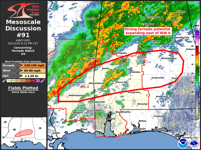
   Mesoscale Discussion 0091
   NWS Storm Prediction Center Norman OK
   0645 PM CST Wed Feb 12 2025

   Areas affected...southern AL and southeast MS

   Concerning...Tornado Watch 6...

   Valid 130045Z - 130215Z

   The severe weather threat for Tornado Watch 6 continues.

   SUMMARY...Strong tornado potential should persist along the surface
   warm front, expanding east of Tornado Watch 6 into an initially
   confined portion of southeast Alabama.

   DISCUSSION...A recently intense supercell from Washington to Clarke
   County, AL produced a potentially strong tornado near the wavy
   surface warm front. This boundary arcs more east-northeast ahead of
   this cell through Wilcox to southern Montgomery County, then pivots
   southeast into Barbour County per latest surface observations. 00Z
   LIX sounding sampled a rather favorable supercell environment, amply
   buoyant with strong deep-layer shear. Enhanced vorticity along the
   slow-moving front will be most favorable for strong tornado
   potential into late evening. With neutral mid-level height change
   through the evening, the number of additional warm-sector supercells
   may be limited. The northern portion of the tornado threat will wane
   quickly where surface dew points hold below 65-66 F.

   ..Grams.. 02/13/2025

   ...Please see www.spc.noaa.gov for graphic product...

   ATTN...WFO...BMX...MOB...JAN...

   LAT...LON   32558718 32638620 32548570 32338555 32008560 31758583
               31628630 31548704 31468773 31298854 31208896 31198960
               31498960 31818914 32198846 32558718
|
|
Top/All Mesoscale Discussions/Forecast Products/Home
|
|


 @NWSSPC