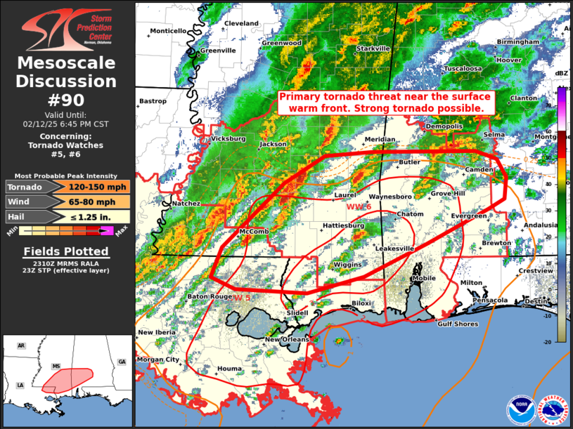
   Mesoscale Discussion 0090
   NWS Storm Prediction Center Norman OK
   0511 PM CST Wed Feb 12 2025

   Areas affected...southeast MS and southwest AL

   Concerning...Tornado Watch 5...6...

   Valid 122311Z - 130045Z

   The severe weather threat for Tornado Watch 5, 6 continues.

   SUMMARY...Primary tornado threat will persist near the warm front,
   especially with discrete/semi-discrete supercells that cross/remain
   anchored along it. A strong tornado is possible.

   DISCUSSION...Several supercells have occurred over the past hour,
   mainly from parts of south-central MS into southwest AL. The
   environment will remain quite conductive to low-level rotation,
   especially near/along the wavy west/east-oriented warm front that
   extends roughly from Simpson County, MS to Montgomery County, AL.
   Discrete and semi-discrete supercells that can continue to
   regenerate across eastern LA into southeast MS will be the most
   likely candidates for eventually sustaining a longer-lived tornado
   as they impinge on the vorticity-enriched warm front. Overall setup,
   with peak STP having increased to a 3 as of 22Z, should favor
   potential for a strong tornado.

   The northern extent of the tornado threat will be limited by cooler
   temperatures. Per early afternoon observed and RAP forecast
   soundings, as storms move north of the 65-66 F isodrosotherm, the
   tornado threat will diminish. Surface winds deeper into the warm
   sector across LA are slightly veered and modulating to some extent
   low-level hodograph curvature.

   ..Grams.. 02/12/2025

   ...Please see www.spc.noaa.gov for graphic product...

   ATTN...WFO...BMX...MOB...JAN...LIX...

   LAT...LON   31109067 31898980 32218923 32268857 32268711 32168681
               31958668 31688672 31578694 31168782 30768868 30578947
               30609048 30749082 31109067
|


 @NWSSPC