|
| Mesoscale Discussion 88 |
|
< Previous MD Next MD >
|
|
Mesoscale Discussion 0088
NWS Storm Prediction Center Norman OK
0148 PM CST Wed Feb 12 2025
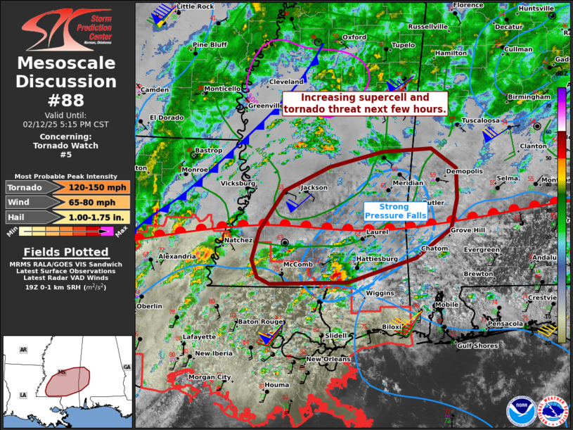
Areas affected...southern into central Mississippi into western and
southwestern Alabama
Concerning...Tornado Watch 5...
Valid 121948Z - 122315Z
The severe weather threat for Tornado Watch 5 continues.
SUMMARY...The threat for severe weather will increase through the
afternoon and into early evening. A few tornadoes appear likely.
DISCUSSION...Visible satellite imagery as well as surface
observations show the continued northward movement of the warm front
across southern MS and AL. Gusty southerly winds over 30 kt exist
over much of eastern LA, indicative of boundary-layer mixing and
strengthening low-level jet. This air mass will spread north through
evening.
Notable pressure falls exist over southern MS and into southwest AL,
just ahead of a rash of developing storms. Given 0-1 SRH of 200-300
m2/s2 and destabilizing air mass, these cells are likely to become
supercellular, with an increasing threat of tornadoes as cells
mature. A strong tornado or two is possible as storms move in
concert with the warm front with access to both large low-level
shear and favorable instability.
..Jewell.. 02/12/2025
...Please see www.spc.noaa.gov for graphic product...
ATTN...WFO...BMX...MOB...JAN...LIX...
LAT...LON 31398831 31078938 31049064 31139085 31369094 31769082
32319041 32648969 32868883 32908804 32628764 32218763
31798773 31398831
|
|
Top/All Mesoscale Discussions/Forecast Products/Home
|
|


 @NWSSPC