 Note:
The expiration time in the watch graphic is amended if the watch is
replaced, cancelled or extended.
Note:
Note:
The expiration time in the watch graphic is amended if the watch is
replaced, cancelled or extended.
Note: Click for
Watch Status Reports.
SEL5
URGENT - IMMEDIATE BROADCAST REQUESTED
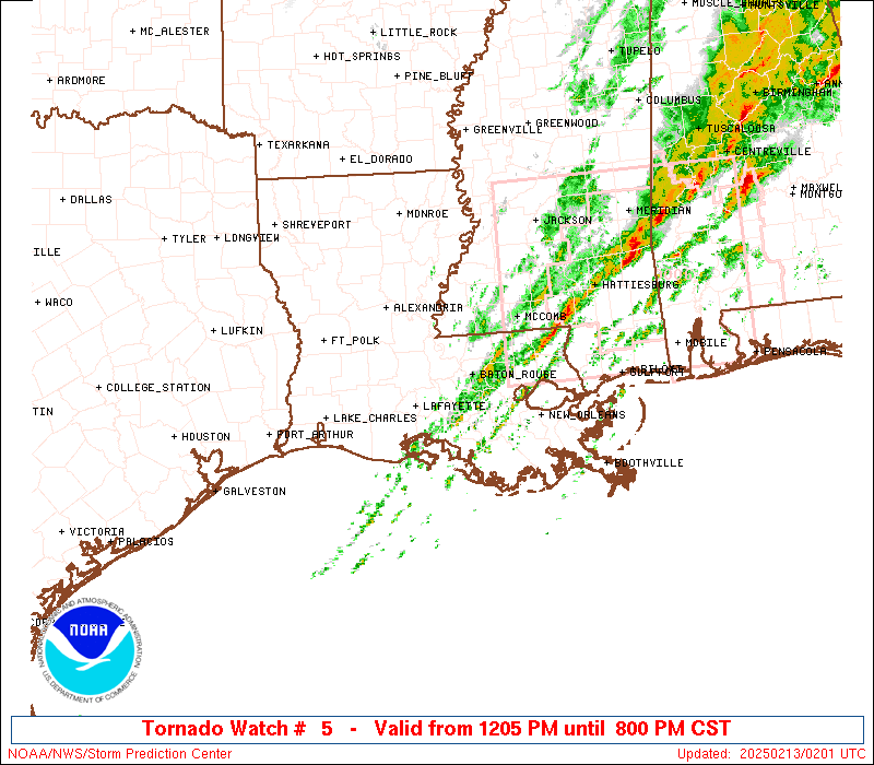
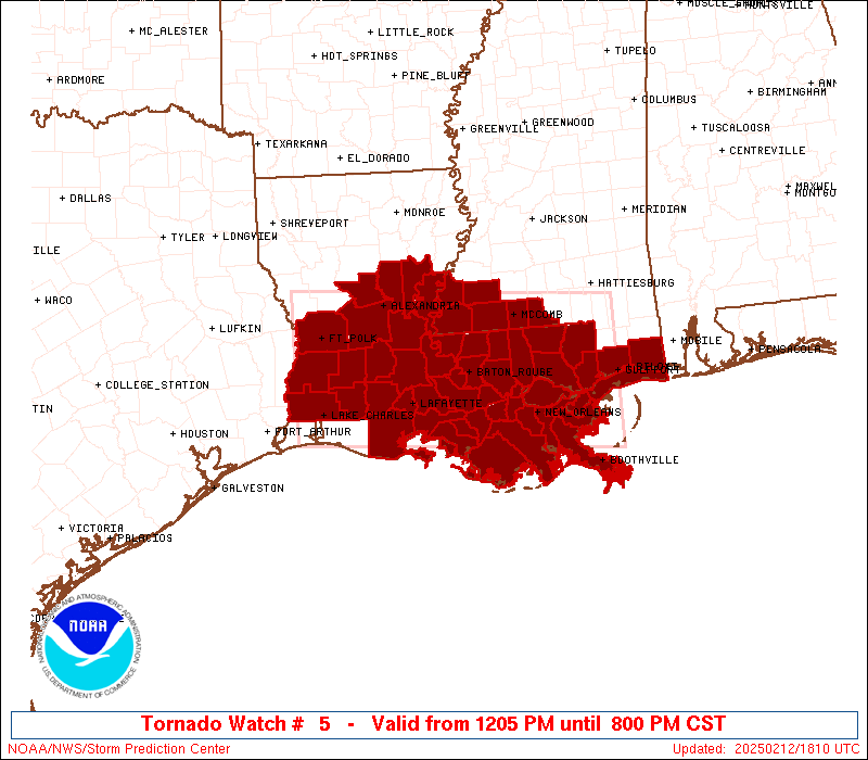
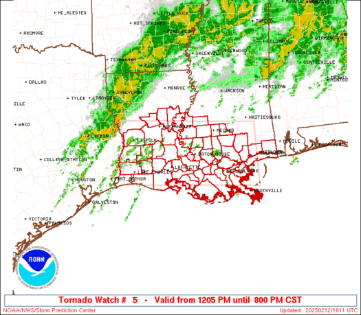
Tornado Watch Number 5
NWS Storm Prediction Center Norman OK
1205 PM CST Wed Feb 12 2025
The NWS Storm Prediction Center has issued a
* Tornado Watch for portions of
Southern and Central Louisiana
Southern Mississippi
Coastal Waters
* Effective this Wednesday afternoon and evening from 1205 PM
until 800 PM CST.
* Primary threats include...
A few tornadoes possible
Scattered damaging wind gusts to 70 mph possible
Isolated large hail events to 1 inch in diameter possible
SUMMARY...Severe thunderstorms are expected to develop and increase
into mid/late afternoon within a warm and increasingly moist
environment. Damaging winds and a few tornadoes may occur through
early evening.
The tornado watch area is approximately along and 65 statute miles
north and south of a line from 35 miles southwest of Fort Polk LA to
Gulfport MS. For a complete depiction of the watch see the
associated watch outline update (WOUS64 KWNS WOU5).
PRECAUTIONARY/PREPAREDNESS ACTIONS...
REMEMBER...A Tornado Watch means conditions are favorable for
tornadoes and severe thunderstorms in and close to the watch
area. Persons in these areas should be on the lookout for
threatening weather conditions and listen for later statements
and possible warnings.
&&
AVIATION...Tornadoes and a few severe thunderstorms with hail
surface and aloft to 1 inch. Extreme turbulence and surface wind
gusts to 60 knots. A few cumulonimbi with maximum tops to 500. Mean
storm motion vector 23030.
...Guyer
 Note:
The Aviation Watch (SAW) product is an approximation to the watch area.
The actual watch is depicted by the shaded areas.
Note:
The Aviation Watch (SAW) product is an approximation to the watch area.
The actual watch is depicted by the shaded areas.
   SAW5
   WW 5 TORNADO LA MS CW 121805Z - 130200Z
   AXIS..65 STATUTE MILES NORTH AND SOUTH OF LINE..
   35SW POE/FORT POLK LA/ - GPT/GULFPORT MS/
   ..AVIATION COORDS.. 55NM N/S /42NW LCH - 42WSW SJI/
   HAIL SURFACE AND ALOFT..1 INCH. WIND GUSTS..60 KNOTS.
   MAX TOPS TO 500. MEAN STORM MOTION VECTOR 23030.

   LAT...LON 31639360 31348907 29468907 29759360

   THIS IS AN APPROXIMATION TO THE WATCH AREA.  FOR A
   COMPLETE DEPICTION OF THE WATCH SEE WOUS64 KWNS
   FOR WOU5.
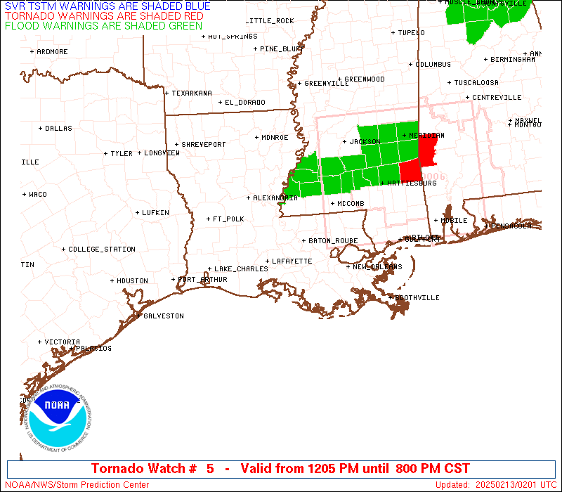
Watch 5 Status Report Messages:
STATUS REPORT #6 ON WW 5
VALID 130035Z - 130140Z
SEVERE WEATHER THREAT CONTINUES RIGHT OF A LINE FROM 15 SSE 7R4
TO 50 NE LFT TO 40 NNE MCB.
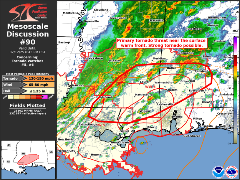
FOR ADDITIONAL INFORMATION SEE MESOSCALE DISCUSSION 90
..WEINMAN..02/13/25
ATTN...WFO...LCH...LIX...JAN...SHV...
&&
STATUS REPORT FOR WT 5
SEVERE WEATHER THREAT CONTINUES FOR THE FOLLOWING AREAS
LAC005-007-033-047-051-057-063-071-075-087-089-091-093-095-103-
105-109-117-121-130140-
LA
. LOUISIANA PARISHES INCLUDED ARE
ASCENSION ASSUMPTION EAST BATON ROUGE
IBERVILLE JEFFERSON LAFOURCHE
LIVINGSTON ORLEANS PLAQUEMINES
ST. BERNARD ST. CHARLES ST. HELENA
ST. JAMES ST. JOHN THE BAPTISTST. TAMMANY
TANGIPAHOA TERREBONNE WASHINGTON
WEST BATON ROUGE
$$
MSC005-045-047-059-109-113-147-130140-
MS
. MISSISSIPPI COUNTIES INCLUDED ARE
AMITE HANCOCK HARRISON
JACKSON PEARL RIVER PIKE
WALTHALL
$$
GMZ530-532-534-130140-
CW
. ADJACENT COASTAL WATERS INCLUDED ARE
LAKE PONTCHARTRAIN AND LAKE MAUREPAS
MISSISSIPPI SOUND
LAKE BORGNE
$$
THE WATCH STATUS MESSAGE IS FOR GUIDANCE PURPOSES ONLY. PLEASE
REFER TO WATCH COUNTY NOTIFICATION STATEMENTS FOR OFFICIAL
INFORMATION ON COUNTIES...INDEPENDENT CITIES AND MARINE ZONES
CLEARED FROM SEVERE THUNDERSTORM AND TORNADO WATCHES.
$$
STATUS REPORT #5 ON WW 5
VALID 122345Z - 130040Z
SEVERE WEATHER THREAT CONTINUES RIGHT OF A LINE FROM 40 WSW 7R4
TO 35 N LFT TO 35 NNW MCB.
FOR ADDITIONAL INFORMATION SEE MESOSCALE DISCUSSION 90
..WEINMAN..02/12/25
ATTN...WFO...LCH...LIX...JAN...SHV...
&&
STATUS REPORT FOR WT 5
SEVERE WEATHER THREAT CONTINUES FOR THE FOLLOWING AREAS
LAC001-005-007-033-037-045-047-051-055-057-063-071-075-077-087-
089-091-093-095-097-099-101-103-105-109-113-117-121-125-
130040-
LA
. LOUISIANA PARISHES INCLUDED ARE
ACADIA ASCENSION ASSUMPTION
EAST BATON ROUGE EAST FELICIANA IBERIA
IBERVILLE JEFFERSON LAFAYETTE
LAFOURCHE LIVINGSTON ORLEANS
PLAQUEMINES POINTE COUPEE ST. BERNARD
ST. CHARLES ST. HELENA ST. JAMES
ST. JOHN THE BAPTIST ST. LANDRY ST. MARTIN
ST. MARY ST. TAMMANY TANGIPAHOA
TERREBONNE VERMILION WASHINGTON
WEST BATON ROUGE WEST FELICIANA
$$
MSC005-037-045-047-059-109-113-147-157-130040-
MS
. MISSISSIPPI COUNTIES INCLUDED ARE
AMITE FRANKLIN HANCOCK
HARRISON JACKSON PEARL RIVER
PIKE WALTHALL WILKINSON
$$
GMZ530-532-534-130040-
CW
. ADJACENT COASTAL WATERS INCLUDED ARE
LAKE PONTCHARTRAIN AND LAKE MAUREPAS
MISSISSIPPI SOUND
LAKE BORGNE
$$
THE WATCH STATUS MESSAGE IS FOR GUIDANCE PURPOSES ONLY. PLEASE
REFER TO WATCH COUNTY NOTIFICATION STATEMENTS FOR OFFICIAL
INFORMATION ON COUNTIES...INDEPENDENT CITIES AND MARINE ZONES
CLEARED FROM SEVERE THUNDERSTORM AND TORNADO WATCHES.
$$
STATUS REPORT #4 ON WW 5
VALID 122245Z - 122340Z
SEVERE WEATHER THREAT CONTINUES RIGHT OF A LINE FROM 40 SSE BPT
TO 10 N HEZ.
FOR ADDITIONAL INFORMATION SEE MESOSCALE DISCUSSION 88
..WEINMAN..02/12/25
ATTN...WFO...LCH...LIX...JAN...SHV...
&&
STATUS REPORT FOR WT 5
SEVERE WEATHER THREAT CONTINUES FOR THE FOLLOWING AREAS
LAC001-005-007-009-029-033-037-039-045-047-051-053-055-057-063-
071-075-077-087-089-091-093-095-097-099-101-103-105-109-113-117-
121-125-122340-
LA
. LOUISIANA PARISHES INCLUDED ARE
ACADIA ASCENSION ASSUMPTION
AVOYELLES CONCORDIA EAST BATON ROUGE
EAST FELICIANA EVANGELINE IBERIA
IBERVILLE JEFFERSON JEFFERSON DAVIS
LAFAYETTE LAFOURCHE LIVINGSTON
ORLEANS PLAQUEMINES POINTE COUPEE
ST. BERNARD ST. CHARLES ST. HELENA
ST. JAMES ST. JOHN THE BAPTISTST. LANDRY
ST. MARTIN ST. MARY ST. TAMMANY
TANGIPAHOA TERREBONNE VERMILION
WASHINGTON WEST BATON ROUGE WEST FELICIANA
$$
MSC001-005-037-045-047-059-109-113-147-157-122340-
MS
. MISSISSIPPI COUNTIES INCLUDED ARE
ADAMS AMITE FRANKLIN
HANCOCK HARRISON JACKSON
PEARL RIVER PIKE WALTHALL
WILKINSON
$$
GMZ530-532-534-122340-
CW
. ADJACENT COASTAL WATERS INCLUDED ARE
LAKE PONTCHARTRAIN AND LAKE MAUREPAS
MISSISSIPPI SOUND
LAKE BORGNE
$$
THE WATCH STATUS MESSAGE IS FOR GUIDANCE PURPOSES ONLY. PLEASE
REFER TO WATCH COUNTY NOTIFICATION STATEMENTS FOR OFFICIAL
INFORMATION ON COUNTIES...INDEPENDENT CITIES AND MARINE ZONES
CLEARED FROM SEVERE THUNDERSTORM AND TORNADO WATCHES.
$$
STATUS REPORT #3 ON WW 5
VALID 122145Z - 122240Z
SEVERE WEATHER THREAT CONTINUES RIGHT OF A LINE FROM 30 SSE BPT
TO 25 SSW ESF TO 15 SSE MLU.
..MOORE..02/12/25
ATTN...WFO...LCH...LIX...JAN...SHV...
&&
STATUS REPORT FOR WT 5
SEVERE WEATHER THREAT CONTINUES FOR THE FOLLOWING AREAS
LAC001-005-007-009-025-029-033-037-039-045-047-051-053-055-057-
063-071-075-077-087-089-091-093-095-097-099-101-103-105-109-113-
117-121-125-122240-
LA
. LOUISIANA PARISHES INCLUDED ARE
ACADIA ASCENSION ASSUMPTION
AVOYELLES CATAHOULA CONCORDIA
EAST BATON ROUGE EAST FELICIANA EVANGELINE
IBERIA IBERVILLE JEFFERSON
JEFFERSON DAVIS LAFAYETTE LAFOURCHE
LIVINGSTON ORLEANS PLAQUEMINES
POINTE COUPEE ST. BERNARD ST. CHARLES
ST. HELENA ST. JAMES ST. JOHN THE BAPTIST
ST. LANDRY ST. MARTIN ST. MARY
ST. TAMMANY TANGIPAHOA TERREBONNE
VERMILION WASHINGTON WEST BATON ROUGE
WEST FELICIANA
$$
MSC001-005-037-045-047-059-109-113-147-157-122240-
MS
. MISSISSIPPI COUNTIES INCLUDED ARE
ADAMS AMITE FRANKLIN
HANCOCK HARRISON JACKSON
PEARL RIVER PIKE WALTHALL
WILKINSON
$$
GMZ530-532-534-122240-
CW
. ADJACENT COASTAL WATERS INCLUDED ARE
LAKE PONTCHARTRAIN AND LAKE MAUREPAS
MISSISSIPPI SOUND
LAKE BORGNE
$$
THE WATCH STATUS MESSAGE IS FOR GUIDANCE PURPOSES ONLY. PLEASE
REFER TO WATCH COUNTY NOTIFICATION STATEMENTS FOR OFFICIAL
INFORMATION ON COUNTIES...INDEPENDENT CITIES AND MARINE ZONES
CLEARED FROM SEVERE THUNDERSTORM AND TORNADO WATCHES.
$$
STATUS REPORT #2 ON WW 5
VALID 122055Z - 122140Z
SEVERE WEATHER THREAT CONTINUES RIGHT OF A LINE FROM 45 WSW POE
TO 10 W ESF TO 20 SSW MLU.
FOR ADDITIONAL INFORMATION SEE MESOSCALE DISCUSSION 88
..MOORE..02/12/25
ATTN...WFO...LCH...LIX...JAN...SHV...
&&
STATUS REPORT FOR WT 5
SEVERE WEATHER THREAT CONTINUES FOR THE FOLLOWING AREAS
LAC001-003-005-007-009-011-019-025-029-033-037-039-045-047-051-
053-055-057-059-063-071-075-077-079-087-089-091-093-095-097-099-
101-103-105-109-113-117-121-125-122140-
LA
. LOUISIANA PARISHES INCLUDED ARE
ACADIA ALLEN ASCENSION
ASSUMPTION AVOYELLES BEAUREGARD
CALCASIEU CATAHOULA CONCORDIA
EAST BATON ROUGE EAST FELICIANA EVANGELINE
IBERIA IBERVILLE JEFFERSON
JEFFERSON DAVIS LAFAYETTE LAFOURCHE
LA SALLE LIVINGSTON ORLEANS
PLAQUEMINES POINTE COUPEE RAPIDES
ST. BERNARD ST. CHARLES ST. HELENA
ST. JAMES ST. JOHN THE BAPTISTST. LANDRY
ST. MARTIN ST. MARY ST. TAMMANY
TANGIPAHOA TERREBONNE VERMILION
WASHINGTON WEST BATON ROUGE WEST FELICIANA
$$
MSC001-005-037-045-047-059-109-113-147-157-122140-
MS
. MISSISSIPPI COUNTIES INCLUDED ARE
ADAMS AMITE FRANKLIN
HANCOCK HARRISON JACKSON
PEARL RIVER PIKE WALTHALL
WILKINSON
$$
GMZ530-532-534-122140-
CW
. ADJACENT COASTAL WATERS INCLUDED ARE
LAKE PONTCHARTRAIN AND LAKE MAUREPAS
MISSISSIPPI SOUND
LAKE BORGNE
$$
THE WATCH STATUS MESSAGE IS FOR GUIDANCE PURPOSES ONLY. PLEASE
REFER TO WATCH COUNTY NOTIFICATION STATEMENTS FOR OFFICIAL
INFORMATION ON COUNTIES...INDEPENDENT CITIES AND MARINE ZONES
CLEARED FROM SEVERE THUNDERSTORM AND TORNADO WATCHES.
$$
STATUS REPORT #1 ON WW 5
VALID 121945Z - 122040Z
THE SEVERE WEATHER THREAT CONTINUES ACROSS THE ENTIRE WATCH AREA.
..MOORE..02/12/25
ATTN...WFO...LCH...LIX...JAN...SHV...
&&
STATUS REPORT FOR WT 5
SEVERE WEATHER THREAT CONTINUES FOR THE FOLLOWING AREAS
LAC001-003-005-007-009-011-019-025-029-033-037-039-043-045-047-
051-053-055-057-059-063-071-075-077-079-087-089-091-093-095-097-
099-101-103-105-109-113-115-117-121-125-122040-
LA
. LOUISIANA PARISHES INCLUDED ARE
ACADIA ALLEN ASCENSION
ASSUMPTION AVOYELLES BEAUREGARD
CALCASIEU CATAHOULA CONCORDIA
EAST BATON ROUGE EAST FELICIANA EVANGELINE
GRANT IBERIA IBERVILLE
JEFFERSON JEFFERSON DAVIS LAFAYETTE
LAFOURCHE LA SALLE LIVINGSTON
ORLEANS PLAQUEMINES POINTE COUPEE
RAPIDES ST. BERNARD ST. CHARLES
ST. HELENA ST. JAMES ST. JOHN THE BAPTIST
ST. LANDRY ST. MARTIN ST. MARY
ST. TAMMANY TANGIPAHOA TERREBONNE
VERMILION VERNON WASHINGTON
WEST BATON ROUGE WEST FELICIANA
$$
MSC001-005-037-045-047-059-109-113-147-157-122040-
MS
. MISSISSIPPI COUNTIES INCLUDED ARE
ADAMS AMITE FRANKLIN
HANCOCK HARRISON JACKSON
PEARL RIVER PIKE WALTHALL
WILKINSON
$$
GMZ530-532-534-122040-
CW
. ADJACENT COASTAL WATERS INCLUDED ARE
LAKE PONTCHARTRAIN AND LAKE MAUREPAS
MISSISSIPPI SOUND
LAKE BORGNE
$$
THE WATCH STATUS MESSAGE IS FOR GUIDANCE PURPOSES ONLY. PLEASE
REFER TO WATCH COUNTY NOTIFICATION STATEMENTS FOR OFFICIAL
INFORMATION ON COUNTIES...INDEPENDENT CITIES AND MARINE ZONES
CLEARED FROM SEVERE THUNDERSTORM AND TORNADO WATCHES.
$$
Note:
Click for Complete Product Text.
Tornadoes
Probability of 2 or more tornadoes
|
Mod (50%)
|
Probability of 1 or more strong (EF2-EF5) tornadoes
|
Low (20%)
|
Wind
Probability of 10 or more severe wind events
|
Mod (50%)
|
Probability of 1 or more wind events > 65 knots
|
Low (20%)
|
Hail
Probability of 10 or more severe hail events
|
Low (20%)
|
Probability of 1 or more hailstones > 2 inches
|
Low (10%)
|
Combined Severe Hail/Wind
Probability of 6 or more combined severe hail/wind events
|
High (80%)
|
For each watch, probabilities for particular events inside the watch
(listed above in each table) are determined by the issuing forecaster.
The "Low" category contains probability values ranging from less than 2%
to 20% (EF2-EF5 tornadoes), less than 5% to 20% (all other probabilities),
"Moderate" from 30% to 60%, and "High" from 70% to greater than 95%.
High values are bolded and lighter in color to provide awareness of
an increased threat for a particular event.


 @NWSSPC