Note:
The expiration time in the watch graphic is amended if the watch is
replaced, cancelled or extended.
Note:
Note:
The expiration time in the watch graphic is amended if the watch is
replaced, cancelled or extended.
Note: Click for
Watch Status Reports.
SEL8
URGENT - IMMEDIATE BROADCAST REQUESTED
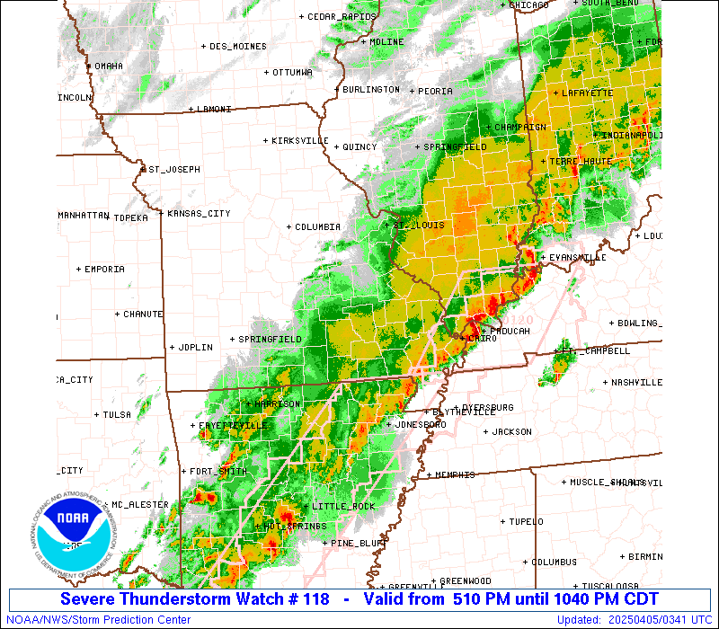
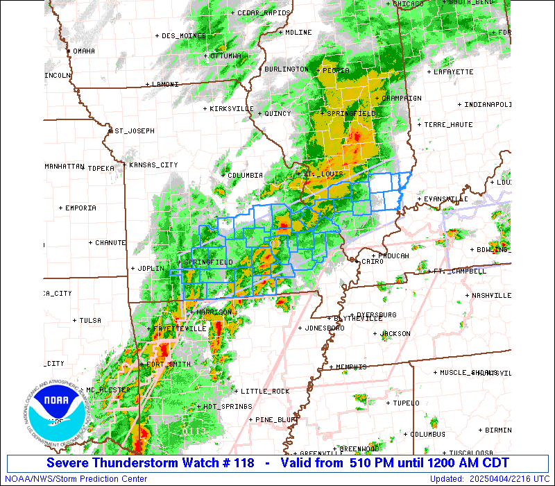
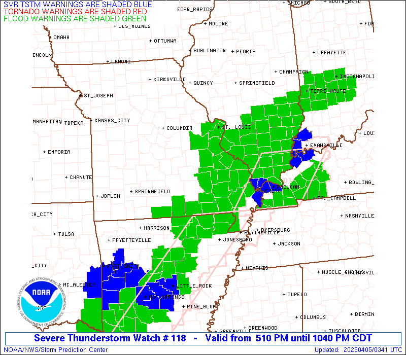
Severe Thunderstorm Watch Number 118
NWS Storm Prediction Center Norman OK
510 PM CDT Fri Apr 4 2025
The NWS Storm Prediction Center has issued a
* Severe Thunderstorm Watch for portions of
South Central Illinois
Southern Missouri
* Effective this Friday afternoon from 510 PM until Midnight CDT.
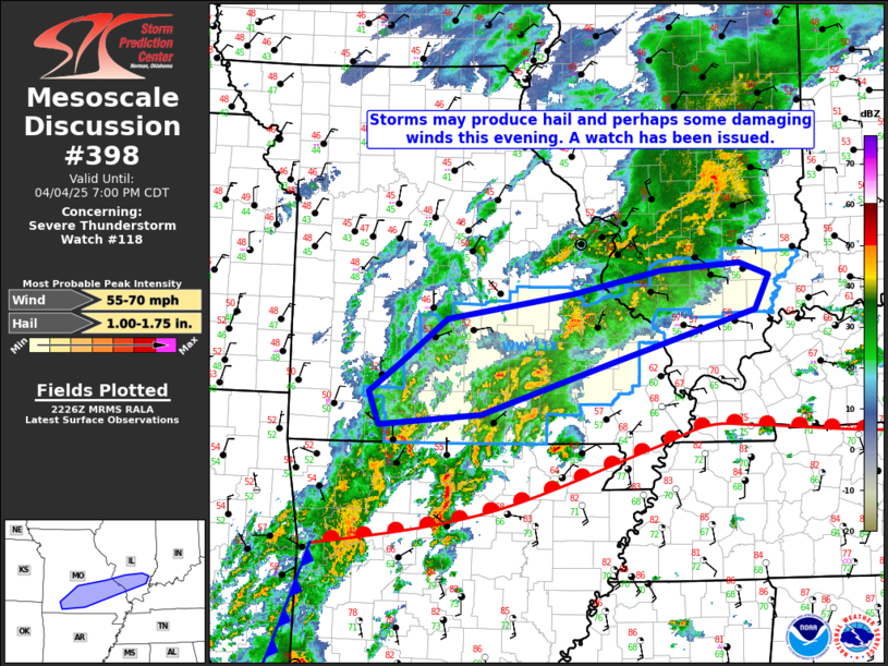
* Primary threats include...
Scattered damaging wind gusts to 60 mph likely
Scattered large hail events to 1.5 inches in diameter likely
A tornado or two possible
SUMMARY...Clusters of thunderstorms will overspread the watch area
through the evening, posing a risk of large hail and perhaps locally
damaging wind gusts.
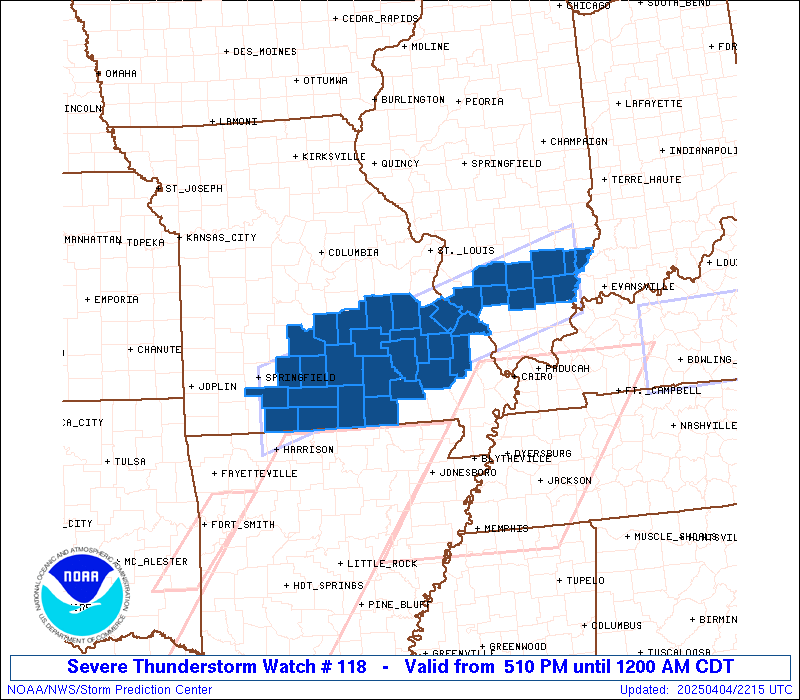
The severe thunderstorm watch area is approximately along and 40
statute miles north and south of a line from 30 miles south of
Springfield MO to 50 miles east of Mount Vernon IL. For a complete
depiction of the watch see the associated watch outline update
(WOUS64 KWNS WOU8).
PRECAUTIONARY/PREPAREDNESS ACTIONS...
REMEMBER...A Severe Thunderstorm Watch means conditions are
favorable for severe thunderstorms in and close to the watch area.
Persons in these areas should be on the lookout for threatening
weather conditions and listen for later statements and possible
warnings. Severe thunderstorms can and occasionally do produce
tornadoes.
&&
OTHER WATCH INFORMATION...CONTINUE...WW 113...WW 114...WW
115...WW 116...WW 117...
AVIATION...A few severe thunderstorms with hail surface and aloft to
1.5 inches. Extreme turbulence and surface wind gusts to 50 knots. A
few cumulonimbi with maximum tops to 450. Mean storm motion vector
24035.
...Hart

   SEL8

   URGENT - IMMEDIATE BROADCAST REQUESTED
   Severe Thunderstorm Watch Number 118
   NWS Storm Prediction Center Norman OK
   510 PM CDT Fri Apr 4 2025

   The NWS Storm Prediction Center has issued a

   * Severe Thunderstorm Watch for portions of
     South Central Illinois
     Southern Missouri

   * Effective this Friday afternoon from 510 PM until Midnight CDT.

   * Primary threats include...
     Scattered damaging wind gusts to 60 mph likely
     Scattered large hail events to 1.5 inches in diameter likely
     A tornado or two possible

   SUMMARY...Clusters of thunderstorms will overspread the watch area
   through the evening, posing a risk of large hail and perhaps locally
   damaging wind gusts.

   The severe thunderstorm watch area is approximately along and 40
   statute miles north and south of a line from 30 miles south of
   Springfield MO to 50 miles east of Mount Vernon IL. For a complete
   depiction of the watch see the associated watch outline update
   (WOUS64 KWNS WOU8).

   PRECAUTIONARY/PREPAREDNESS ACTIONS...

   REMEMBER...A Severe Thunderstorm Watch means conditions are
   favorable for severe thunderstorms in and close to the watch area.
   Persons in these areas should be on the lookout for threatening
   weather conditions and listen for later statements and possible
   warnings. Severe thunderstorms can and occasionally do produce
   tornadoes.

   &&

   OTHER WATCH INFORMATION...CONTINUE...WW 113...WW 114...WW
   115...WW 116...WW 117...

   AVIATION...A few severe thunderstorms with hail surface and aloft to
   1.5 inches. Extreme turbulence and surface wind gusts to 50 knots. A
   few cumulonimbi with maximum tops to 450. Mean storm motion vector
   24035.

   ...Hart
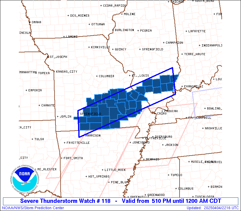
 Note:
The Aviation Watch (SAW) product is an approximation to the watch area.
The actual watch is depicted by the shaded areas.
Note:
The Aviation Watch (SAW) product is an approximation to the watch area.
The actual watch is depicted by the shaded areas.
   SAW8
   WW 118 SEVERE TSTM IL MO 042210Z - 050500Z
   AXIS..40 STATUTE MILES NORTH AND SOUTH OF LINE..
   30S SGF/SPRINGFIELD MO/ - 50E MVN/MOUNT VERNON IL/
   ..AVIATION COORDS.. 35NM N/S /35S SGF - 25NNW PXV/
   HAIL SURFACE AND ALOFT..1.5 INCHES. WIND GUSTS..50 KNOTS.
   MAX TOPS TO 450. MEAN STORM MOTION VECTOR 24035.

   LAT...LON 37369338 38908795 37748795 36219338

   THIS IS AN APPROXIMATION TO THE WATCH AREA.  FOR A
   COMPLETE DEPICTION OF THE WATCH SEE WOUS64 KWNS
   FOR WOU8.
Watch 118 Status Report Messages:
STATUS REPORT #4 ON WW 118

VALID 050240Z - 050340Z

SEVERE WEATHER THREAT CONTINUES RIGHT OF A LINE FROM 30 WSW CGI
TO 15 ENE SLO.

..SUPINIE..04/05/25

ATTN...WFO...PAH...LSX...SGF...

&&

STATUS REPORT FOR WS 118

SEVERE WEATHER THREAT CONTINUES FOR THE FOLLOWING AREAS

ILC047-055-065-081-185-191-193-050340-

IL
.    ILLINOIS COUNTIES INCLUDED ARE

EDWARDS 	     FRANKLIN		 HAMILTON
JEFFERSON	     WABASH		 WAYNE
WHITE
$$


THE WATCH STATUS MESSAGE IS FOR GUIDANCE PURPOSES ONLY.  PLEASE
REFER TO WATCH COUNTY NOTIFICATION STATEMENTS FOR OFFICIAL
INFORMATION ON COUNTIES...INDEPENDENT CITIES AND MARINE ZONES
CLEARED FROM SEVERE THUNDERSTORM AND TORNADO WATCHES.
$$

STATUS REPORT #3 ON WW 118

VALID 050145Z - 050240Z

SEVERE WEATHER THREAT CONTINUES RIGHT OF A LINE FROM 30 ESE UMN
TO 30 NW POF TO 5 WNW SLO.

..SUPINIE..04/05/25

ATTN...WFO...PAH...LSX...SGF...

&&

STATUS REPORT FOR WS 118

SEVERE WEATHER THREAT CONTINUES FOR THE FOLLOWING AREAS

ILC047-055-065-081-145-185-191-193-050240-

IL
.    ILLINOIS COUNTIES INCLUDED ARE

EDWARDS 	     FRANKLIN		 HAMILTON
JEFFERSON	     PERRY		 WABASH
WAYNE		     WHITE
$$


MOC017-035-091-149-153-157-213-223-050240-

MO
.    MISSOURI COUNTIES INCLUDED ARE

BOLLINGER	     CARTER		 HOWELL
OREGON		     OZARK		 PERRY
TANEY		     WAYNE
$$


THE WATCH STATUS MESSAGE IS FOR GUIDANCE PURPOSES ONLY.  PLEASE
REFER TO WATCH COUNTY NOTIFICATION STATEMENTS FOR OFFICIAL
INFORMATION ON COUNTIES...INDEPENDENT CITIES AND MARINE ZONES
CLEARED FROM SEVERE THUNDERSTORM AND TORNADO WATCHES.
$$

STATUS REPORT #2 ON WW 118

VALID 050045Z - 050140Z

SEVERE WEATHER THREAT CONTINUES RIGHT OF A LINE FROM 25 ESE UMN
TO 30 WSW FAM TO 25 WSW BLV.

..SUPINIE..04/05/25

ATTN...WFO...PAH...LSX...SGF...

&&

STATUS REPORT FOR WS 118

SEVERE WEATHER THREAT CONTINUES FOR THE FOLLOWING AREAS

ILC047-055-065-081-145-157-185-189-191-193-050140-

IL
.    ILLINOIS COUNTIES INCLUDED ARE

EDWARDS 	     FRANKLIN		 HAMILTON
JEFFERSON	     PERRY		 RANDOLPH
WABASH		     WASHINGTON 	 WAYNE
WHITE
$$


MOC017-035-067-091-093-123-149-153-157-179-186-187-203-213-223-
050140-

MO
.    MISSOURI COUNTIES INCLUDED ARE

BOLLINGER	     CARTER		 DOUGLAS
HOWELL		     IRON		 MADISON
OREGON		     OZARK		 PERRY
REYNOLDS	     STE. GENEVIEVE	 ST. FRANCOIS
SHANNON 	     TANEY		 WAYNE
$$


THE WATCH STATUS MESSAGE IS FOR GUIDANCE PURPOSES ONLY.  PLEASE
REFER TO WATCH COUNTY NOTIFICATION STATEMENTS FOR OFFICIAL
INFORMATION ON COUNTIES...INDEPENDENT CITIES AND MARINE ZONES
CLEARED FROM SEVERE THUNDERSTORM AND TORNADO WATCHES.
$$

STATUS REPORT #1 ON WW 118

VALID 042305Z - 050040Z

SEVERE WEATHER THREAT CONTINUES RIGHT OF A LINE FROM 25 S SGF TO
40 ESE SGF TO 5 SW VIH.

..LYONS..04/04/25

ATTN...WFO...PAH...LSX...SGF...

&&

STATUS REPORT FOR WS 118

SEVERE WEATHER THREAT CONTINUES FOR THE FOLLOWING AREAS

ILC047-055-065-081-145-157-185-189-191-193-050040-

IL
.    ILLINOIS COUNTIES INCLUDED ARE

EDWARDS 	     FRANKLIN		 HAMILTON
JEFFERSON	     PERRY		 RANDOLPH
WABASH		     WASHINGTON 	 WAYNE
WHITE
$$


MOC017-035-055-065-067-091-093-123-149-153-157-161-179-186-187-
203-213-215-221-223-229-050040-

MO
.    MISSOURI COUNTIES INCLUDED ARE

BOLLINGER	     CARTER		 CRAWFORD
DENT		     DOUGLAS		 HOWELL
IRON		     MADISON		 OREGON
OZARK		     PERRY		 PHELPS
REYNOLDS	     STE. GENEVIEVE	 ST. FRANCOIS
SHANNON 	     TANEY		 TEXAS
WASHINGTON	     WAYNE		 WRIGHT
$$


THE WATCH STATUS MESSAGE IS FOR GUIDANCE PURPOSES ONLY.  PLEASE
REFER TO WATCH COUNTY NOTIFICATION STATEMENTS FOR OFFICIAL
INFORMATION ON COUNTIES...INDEPENDENT CITIES AND MARINE ZONES
CLEARED FROM SEVERE THUNDERSTORM AND TORNADO WATCHES.
$$
Note:
Click for Complete Product Text.
Tornadoes
Probability of 2 or more tornadoes
|
Low (20%)
|
Probability of 1 or more strong (EF2-EF5) tornadoes
|
Low (10%)
|
Wind
Probability of 10 or more severe wind events
|
Mod (60%)
|
Probability of 1 or more wind events > 65 knots
|
Low (20%)
|
Hail
Probability of 10 or more severe hail events
|
Mod (60%)
|
Probability of 1 or more hailstones > 2 inches
|
Low (10%)
|
Combined Severe Hail/Wind
Probability of 6 or more combined severe hail/wind events
|
High (>95%)
|
For each watch, probabilities for particular events inside the watch
(listed above in each table) are determined by the issuing forecaster.
The "Low" category contains probability values ranging from less than 2%
to 20% (EF2-EF5 tornadoes), less than 5% to 20% (all other probabilities),
"Moderate" from 30% to 60%, and "High" from 70% to greater than 95%.
High values are bolded and lighter in color to provide awareness of
an increased threat for a particular event.


 @NWSSPC