 Note:
The expiration time in the watch graphic is amended if the watch is
replaced, cancelled or extended.
Note:
Note:
The expiration time in the watch graphic is amended if the watch is
replaced, cancelled or extended.
Note: Click for
Watch Status Reports.
SEL3
URGENT - IMMEDIATE BROADCAST REQUESTED
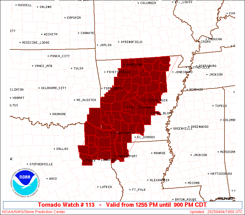
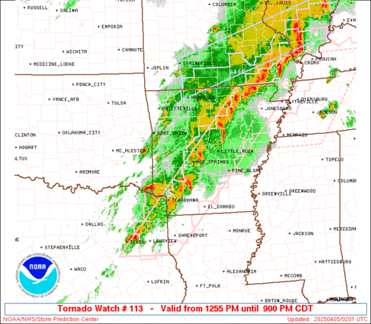
Tornado Watch Number 113
NWS Storm Prediction Center Norman OK
1255 PM CDT Fri Apr 4 2025
The NWS Storm Prediction Center has issued a
* Tornado Watch for portions of
Southwest, central and northern Arkansas
Extreme northwest Louisiana
Extreme southeast Oklahoma
Northeast Texas
* Effective this Friday afternoon and evening from 1255 PM until
900 PM CDT.
* Primary threats include...
Several tornadoes and a couple intense tornadoes likely
Widespread large hail and scattered very large hail events to
2.5 inches in diameter likely
Scattered damaging winds likely with isolated significant gusts
to 75 mph possible
SUMMARY...Supercell development is expected along a surface front
and into the warm sector this afternoon from northeast Texas
northeastward into Arkansas. The storm environment will support the
potential for a few strong (EF2-EF3) tornadoes, very large hail to
2.5 inches in diameter, and damaging gusts up to 75 mph as storms
congeal into multiple clusters later this afternoon.
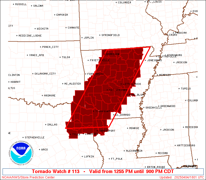
The tornado watch area is approximately along and 75 statute miles
east and west of a line from 50 miles east northeast of Flippin AR
to 60 miles south southwest of Texarkana AR. For a complete
depiction of the watch see the associated watch outline update
(WOUS64 KWNS WOU3).
PRECAUTIONARY/PREPAREDNESS ACTIONS...
REMEMBER...A Tornado Watch means conditions are favorable for
tornadoes and severe thunderstorms in and close to the watch
area. Persons in these areas should be on the lookout for
threatening weather conditions and listen for later statements
and possible warnings.
&&
AVIATION...Tornadoes and a few severe thunderstorms with hail
surface and aloft to 2.5 inches. Extreme turbulence and surface wind
gusts to 65 knots. A few cumulonimbi with maximum tops to 550. Mean
storm motion vector 23035.
...Thompson
   SEL3

   URGENT - IMMEDIATE BROADCAST REQUESTED
   Tornado Watch Number 113
   NWS Storm Prediction Center Norman OK
   1255 PM CDT Fri Apr 4 2025

   The NWS Storm Prediction Center has issued a

   * Tornado Watch for portions of
     Southwest, central and northern Arkansas
     Extreme northwest Louisiana
     Extreme southeast Oklahoma
     Northeast Texas

   * Effective this Friday afternoon and evening from 1255 PM until
     900 PM CDT.

   * Primary threats include...
     Several tornadoes and a couple intense tornadoes likely
     Widespread large hail and scattered very large hail events to
       2.5 inches in diameter likely
     Scattered damaging winds likely with isolated significant gusts
       to 75 mph possible

   SUMMARY...Supercell development is expected along a surface front
   and into the warm sector this afternoon from northeast Texas
   northeastward into Arkansas.  The storm environment will support the
   potential for a few strong (EF2-EF3) tornadoes, very large hail to
   2.5 inches in diameter, and damaging gusts up to 75 mph as storms
   congeal into multiple clusters later this afternoon.

   The tornado watch area is approximately along and 75 statute miles
   east and west of a line from 50 miles east northeast of Flippin AR
   to 60 miles south southwest of Texarkana AR. For a complete
   depiction of the watch see the associated watch outline update
   (WOUS64 KWNS WOU3).

   PRECAUTIONARY/PREPAREDNESS ACTIONS...

   REMEMBER...A Tornado Watch means conditions are favorable for
   tornadoes and severe thunderstorms in and close to the watch
   area. Persons in these areas should be on the lookout for
   threatening weather conditions and listen for later statements
   and possible warnings.

   &&

   AVIATION...Tornadoes and a few severe thunderstorms with hail
   surface and aloft to 2.5 inches. Extreme turbulence and surface wind
   gusts to 65 knots. A few cumulonimbi with maximum tops to 550. Mean
   storm motion vector 23035.

   ...Thompson
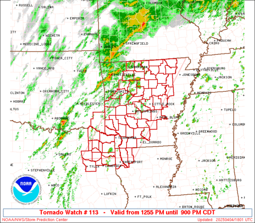
 Note:
The Aviation Watch (SAW) product is an approximation to the watch area.
The actual watch is depicted by the shaded areas.
Note:
The Aviation Watch (SAW) product is an approximation to the watch area.
The actual watch is depicted by the shaded areas.
   SAW3
   WW 113 TORNADO AR LA OK TX 041755Z - 050200Z
   AXIS..75 STATUTE MILES EAST AND WEST OF LINE..
   50ENE FLP/FLIPPIN AR/ - 60SSW TXK/TEXARKANA AR/
   ..AVIATION COORDS.. 65NM E/W /40WNW ARG - 23NE GGG/
   HAIL SURFACE AND ALOFT..2.5 INCHES. WIND GUSTS..65 KNOTS.
   MAX TOPS TO 550. MEAN STORM MOTION VECTOR 23035.

   LAT...LON 36479029 32649311 32649568 36479299

   THIS IS AN APPROXIMATION TO THE WATCH AREA.  FOR A
   COMPLETE DEPICTION OF THE WATCH SEE WOUS64 KWNS
   FOR WOU3.
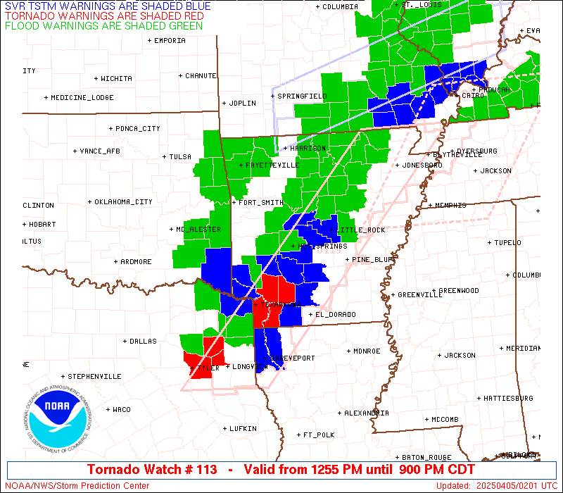
Watch 113 Status Report Messages:
STATUS REPORT #4 ON WW 113

VALID 042245Z - 042340Z

SEVERE WEATHER THREAT CONTINUES RIGHT OF A LINE FROM 25 SW TYR TO
40 NNE TYR TO 20 SW DEQ TO 30 SSE RKR TO 15 SSW RKR.

..LYONS..04/04/25

ATTN...WFO...LZK...SHV...

&&

STATUS REPORT FOR WT 113

SEVERE WEATHER THREAT CONTINUES FOR THE FOLLOWING AREAS

ARC001-005-009-013-019-023-025-027-029-039-045-049-051-053-057-
059-061-063-065-067-069-071-073-075-081-083-085-089-091-095-097-
099-101-103-105-109-113-115-117-119-121-125-127-129-133-135-137-
141-145-147-149-042340-

AR
.    ARKANSAS COUNTIES INCLUDED ARE

ARKANSAS	     BAXTER		 BOONE
CALHOUN 	     CLARK		 CLEBURNE
CLEVELAND	     COLUMBIA		 CONWAY
DALLAS		     FAULKNER		 FULTON
GARLAND 	     GRANT		 HEMPSTEAD
HOT SPRING	     HOWARD		 INDEPENDENCE
IZARD		     JACKSON		 JEFFERSON
JOHNSON 	     LAFAYETTE		 LAWRENCE
LITTLE RIVER	     LOGAN		 LONOKE
MARION		     MILLER		 MONROE
MONTGOMERY	     NEVADA		 NEWTON
OUACHITA	     PERRY		 PIKE
POLK		     POPE		 PRAIRIE
PULASKI 	     RANDOLPH		 SALINE
SCOTT		     SEARCY		 SEVIER
SHARP		     STONE		 VAN BUREN
WHITE		     WOODRUFF		 YELL
$$


LAC015-017-031-119-042340-

LA
.    LOUISIANA PARISHES INCLUDED ARE

BOSSIER 	     CADDO		 DE SOTO
WEBSTER
$$


OKC089-042340-

OK
.    OKLAHOMA COUNTIES INCLUDED ARE

MCCURTAIN
$$


TXC005-037-063-067-073-183-203-315-343-347-365-401-405-419-423-
449-459-042340-

TX
.    TEXAS COUNTIES INCLUDED ARE

ANGELINA	     BOWIE		 CAMP
CASS		     CHEROKEE		 GREGG
HARRISON	     MARION		 MORRIS
NACOGDOCHES	     PANOLA		 RUSK
SAN AUGUSTINE	     SHELBY		 SMITH
TITUS		     UPSHUR
$$


THE WATCH STATUS MESSAGE IS FOR GUIDANCE PURPOSES ONLY.  PLEASE
REFER TO WATCH COUNTY NOTIFICATION STATEMENTS FOR OFFICIAL
INFORMATION ON COUNTIES...INDEPENDENT CITIES AND MARINE ZONES
CLEARED FROM SEVERE THUNDERSTORM AND TORNADO WATCHES.
$$

STATUS REPORT #3 ON WW 113

VALID 042150Z - 042240Z

THE SEVERE WEATHER THREAT CONTINUES ACROSS THE ENTIRE WATCH AREA.

..LYONS..04/04/25

ATTN...WFO...LZK...SHV...

&&

STATUS REPORT FOR WT 113

SEVERE WEATHER THREAT CONTINUES FOR THE FOLLOWING AREAS

ARC005-009-013-019-023-025-027-029-039-045-049-051-053-057-059-
061-063-065-067-069-071-073-075-081-083-085-089-091-097-099-101-
103-105-109-113-115-117-119-121-125-127-129-133-135-137-141-145-
147-149-042240-

AR
.    ARKANSAS COUNTIES INCLUDED ARE

BAXTER		     BOONE		 CALHOUN
CLARK		     CLEBURNE		 CLEVELAND
COLUMBIA	     CONWAY		 DALLAS
FAULKNER	     FULTON		 GARLAND
GRANT		     HEMPSTEAD		 HOT SPRING
HOWARD		     INDEPENDENCE	 IZARD
JACKSON 	     JEFFERSON		 JOHNSON
LAFAYETTE	     LAWRENCE		 LITTLE RIVER
LOGAN		     LONOKE		 MARION
MILLER		     MONTGOMERY 	 NEVADA
NEWTON		     OUACHITA		 PERRY
PIKE		     POLK		 POPE
PRAIRIE 	     PULASKI		 RANDOLPH
SALINE		     SCOTT		 SEARCY
SEVIER		     SHARP		 STONE
VAN BUREN	     WHITE		 WOODRUFF
YELL
$$


LAC015-017-119-042240-

LA
.    LOUISIANA PARISHES INCLUDED ARE

BOSSIER 	     CADDO		 WEBSTER
$$


OKC089-042240-

OK
.    OKLAHOMA COUNTIES INCLUDED ARE

MCCURTAIN
$$


TXC037-063-067-159-183-203-315-343-387-423-449-459-499-042240-

TX
.    TEXAS COUNTIES INCLUDED ARE

BOWIE		     CAMP		 CASS
FRANKLIN	     GREGG		 HARRISON
MARION		     MORRIS		 RED RIVER
SMITH		     TITUS		 UPSHUR
WOOD
$$


THE WATCH STATUS MESSAGE IS FOR GUIDANCE PURPOSES ONLY.  PLEASE
REFER TO WATCH COUNTY NOTIFICATION STATEMENTS FOR OFFICIAL
INFORMATION ON COUNTIES...INDEPENDENT CITIES AND MARINE ZONES
CLEARED FROM SEVERE THUNDERSTORM AND TORNADO WATCHES.
$$

STATUS REPORT #2 ON WW 113

VALID 042055Z - 042140Z

THE SEVERE WEATHER THREAT CONTINUES ACROSS THE ENTIRE WATCH AREA.

..LYONS..04/04/25

ATTN...WFO...LZK...SHV...

&&

STATUS REPORT FOR WT 113

SEVERE WEATHER THREAT CONTINUES FOR THE FOLLOWING AREAS

ARC005-009-013-019-023-025-027-029-039-045-049-051-053-057-059-
061-063-065-067-069-071-073-075-081-083-085-089-091-097-099-101-
103-105-109-113-115-117-119-121-125-127-129-133-135-137-141-145-
147-149-042140-

AR
.    ARKANSAS COUNTIES INCLUDED ARE

BAXTER		     BOONE		 CALHOUN
CLARK		     CLEBURNE		 CLEVELAND
COLUMBIA	     CONWAY		 DALLAS
FAULKNER	     FULTON		 GARLAND
GRANT		     HEMPSTEAD		 HOT SPRING
HOWARD		     INDEPENDENCE	 IZARD
JACKSON 	     JEFFERSON		 JOHNSON
LAFAYETTE	     LAWRENCE		 LITTLE RIVER
LOGAN		     LONOKE		 MARION
MILLER		     MONTGOMERY 	 NEVADA
NEWTON		     OUACHITA		 PERRY
PIKE		     POLK		 POPE
PRAIRIE 	     PULASKI		 RANDOLPH
SALINE		     SCOTT		 SEARCY
SEVIER		     SHARP		 STONE
VAN BUREN	     WHITE		 WOODRUFF
YELL
$$


LAC015-017-119-042140-

LA
.    LOUISIANA PARISHES INCLUDED ARE

BOSSIER 	     CADDO		 WEBSTER
$$


OKC089-042140-

OK
.    OKLAHOMA COUNTIES INCLUDED ARE

MCCURTAIN
$$


TXC037-063-067-159-183-203-315-343-387-423-449-459-499-042140-

TX
.    TEXAS COUNTIES INCLUDED ARE

BOWIE		     CAMP		 CASS
FRANKLIN	     GREGG		 HARRISON
MARION		     MORRIS		 RED RIVER
SMITH		     TITUS		 UPSHUR
WOOD
$$


THE WATCH STATUS MESSAGE IS FOR GUIDANCE PURPOSES ONLY.  PLEASE
REFER TO WATCH COUNTY NOTIFICATION STATEMENTS FOR OFFICIAL
INFORMATION ON COUNTIES...INDEPENDENT CITIES AND MARINE ZONES
CLEARED FROM SEVERE THUNDERSTORM AND TORNADO WATCHES.
$$

STATUS REPORT #1 ON WW 113

VALID 041920Z - 042040Z

THE SEVERE WEATHER THREAT CONTINUES ACROSS THE ENTIRE WATCH AREA.

..DEAN..04/04/25

ATTN...WFO...LZK...SHV...

&&

STATUS REPORT FOR WT 113

SEVERE WEATHER THREAT CONTINUES FOR THE FOLLOWING AREAS

ARC005-009-013-019-023-025-027-029-039-045-049-051-053-057-059-
061-063-065-067-069-071-073-075-081-083-085-089-091-097-099-101-
103-105-109-113-115-117-119-121-125-127-129-133-135-137-141-145-
147-149-042040-

AR
.    ARKANSAS COUNTIES INCLUDED ARE

BAXTER		     BOONE		 CALHOUN
CLARK		     CLEBURNE		 CLEVELAND
COLUMBIA	     CONWAY		 DALLAS
FAULKNER	     FULTON		 GARLAND
GRANT		     HEMPSTEAD		 HOT SPRING
HOWARD		     INDEPENDENCE	 IZARD
JACKSON 	     JEFFERSON		 JOHNSON
LAFAYETTE	     LAWRENCE		 LITTLE RIVER
LOGAN		     LONOKE		 MARION
MILLER		     MONTGOMERY 	 NEVADA
NEWTON		     OUACHITA		 PERRY
PIKE		     POLK		 POPE
PRAIRIE 	     PULASKI		 RANDOLPH
SALINE		     SCOTT		 SEARCY
SEVIER		     SHARP		 STONE
VAN BUREN	     WHITE		 WOODRUFF
YELL
$$


LAC015-017-031-119-042040-

LA
.    LOUISIANA PARISHES INCLUDED ARE

BOSSIER 	     CADDO		 DE SOTO
WEBSTER
$$


OKC089-042040-

OK
.    OKLAHOMA COUNTIES INCLUDED ARE

MCCURTAIN
$$


TXC005-037-063-067-073-159-183-203-315-343-347-365-387-401-405-
419-423-449-459-499-042040-

TX
.    TEXAS COUNTIES INCLUDED ARE

ANGELINA	     BOWIE		 CAMP
CASS		     CHEROKEE		 FRANKLIN
GREGG		     HARRISON		 MARION
MORRIS		     NACOGDOCHES	 PANOLA
RED RIVER	     RUSK		 SAN AUGUSTINE
SHELBY		     SMITH		 TITUS
UPSHUR		     WOOD
$$


THE WATCH STATUS MESSAGE IS FOR GUIDANCE PURPOSES ONLY.  PLEASE
REFER TO WATCH COUNTY NOTIFICATION STATEMENTS FOR OFFICIAL
INFORMATION ON COUNTIES...INDEPENDENT CITIES AND MARINE ZONES
CLEARED FROM SEVERE THUNDERSTORM AND TORNADO WATCHES.
$$
Note:
Click for Complete Product Text.
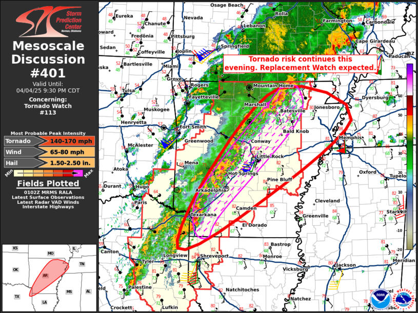
Tornadoes
Probability of 2 or more tornadoes
|
High (80%)
|
Probability of 1 or more strong (EF2-EF5) tornadoes
|
Mod (60%)
|
Wind
Probability of 10 or more severe wind events
|
Mod (60%)
|
Probability of 1 or more wind events > 65 knots
|
Mod (40%)
|
Hail
Probability of 10 or more severe hail events
|
High (80%)
|
Probability of 1 or more hailstones > 2 inches
|
High (80%)
|
Combined Severe Hail/Wind
Probability of 6 or more combined severe hail/wind events
|
High (>95%)
|
For each watch, probabilities for particular events inside the watch
(listed above in each table) are determined by the issuing forecaster.
The "Low" category contains probability values ranging from less than 2%
to 20% (EF2-EF5 tornadoes), less than 5% to 20% (all other probabilities),
"Moderate" from 30% to 60%, and "High" from 70% to greater than 95%.
High values are bolded and lighter in color to provide awareness of
an increased threat for a particular event.


 @NWSSPC