|
| Mesoscale Discussion 398 |
|
[an error occurred while processing this directive]
|
|
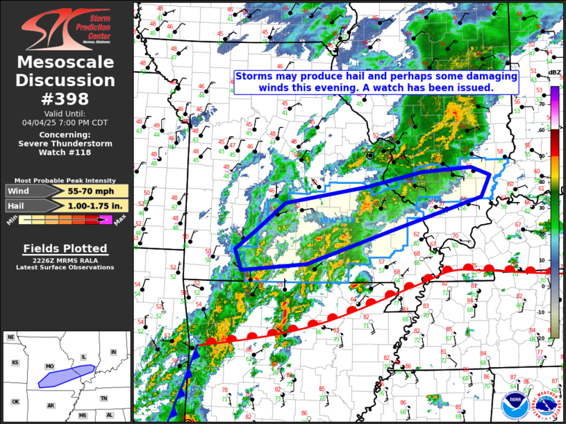
   Mesoscale Discussion 0398
   NWS Storm Prediction Center Norman OK
   0528 PM CDT Fri Apr 04 2025

   Areas affected...parts of southern Missouri and southern Illinois

   Concerning...Severe Thunderstorm Watch 118...

   Valid 042228Z - 050000Z

   The severe weather threat for Severe Thunderstorm Watch 118
   continues.

   SUMMARY...Storms north of the warm front may produce hail and
   perhaps some damaging gusts this evening, and a watch has been
   issued.

   DISCUSSION...Scattered storms are ongoing to the north of a warm
   front lifting slowly northward across parts of northern Arkansas,
   and a watch has been issued in this area. ACARS profiles from STL
   show a strong surface stable layer north of the front that has been
   getting shallower over time as it is eroded by a strong
   south-southwesterly low-level jet. Above the surface stable layer,
   ample buoyancy for hail production along with strong deep-layer
   shear may support a hail risk. Additionally, with the stable layer
   eroding with time, some downdrafts may be able to penetrate to the
   surface to produce damaging gusts, given the strong flow aloft.
   However, poor lapse rates aloft and messy storm modes may limit both
   the hail threat due to higher freezing levels and weaker updrafts
   and the wind threat due to weaker downdrafts.

   ..Supinie.. 04/04/2025

   ...Please see www.spc.noaa.gov for graphic product...

   ATTN...WFO...PAH...LSX...SGF...

   LAT...LON   37049353 37389309 37859247 38129074 38388952 38448847
               38318807 37938826 37379020 36819201 36699340 37049353

   MOST PROBABLE PEAK WIND GUST...55-70 MPH
   MOST PROBABLE PEAK HAIL SIZE...1.00-1.75 IN
|
|
Top/All Mesoscale Discussions/Forecast Products/Home
|
|


 @NWSSPC