Note:
The expiration time in the watch graphic is amended if the watch is
replaced, cancelled or extended.
Note:
Note:
The expiration time in the watch graphic is amended if the watch is
replaced, cancelled or extended.
Note: Click for
Watch Status Reports.
SEL5
URGENT - IMMEDIATE BROADCAST REQUESTED
Tornado Watch Number 115
NWS Storm Prediction Center Norman OK
255 PM CDT Fri Apr 4 2025
The NWS Storm Prediction Center has issued a
* Tornado Watch for portions of
Northeast Arkansas
Extreme southern Illinois
Western Kentucky
Southeast Missouri
Norhern Mississippi
Western and Middle Tennessee
* Effective this Friday afternoon and evening from 255 PM until
1000 PM CDT.
* Primary threats include...
A few tornadoes likely with a couple intense tornadoes possible
Scattered damaging winds likely with isolated significant gusts
to 75 mph possible
Scattered large hail likely with isolated very large hail events
to 2 inches in diameter possible
SUMMARY...Widely scattered supercell development is expected this
afternoon from northern Mississippi across western/Middle Tennessee
into western Kentucky. The storm environment supports the potential
for several tornadoes (including an isolated strong tornado), large
hail up to 2 inches in diameter, and isolated damaging gusts. The
potential for damaging winds up to 75 mph will increase later this
evening into early tonight as storm clusters spread into southeast
Missouri from Arkansas.
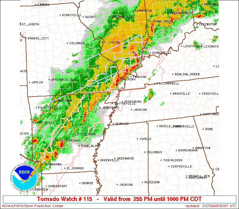
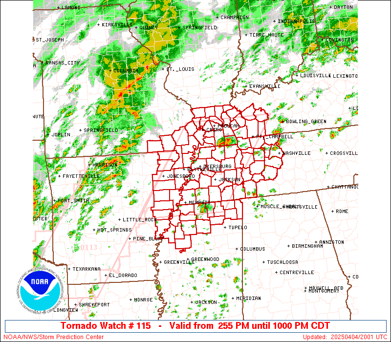
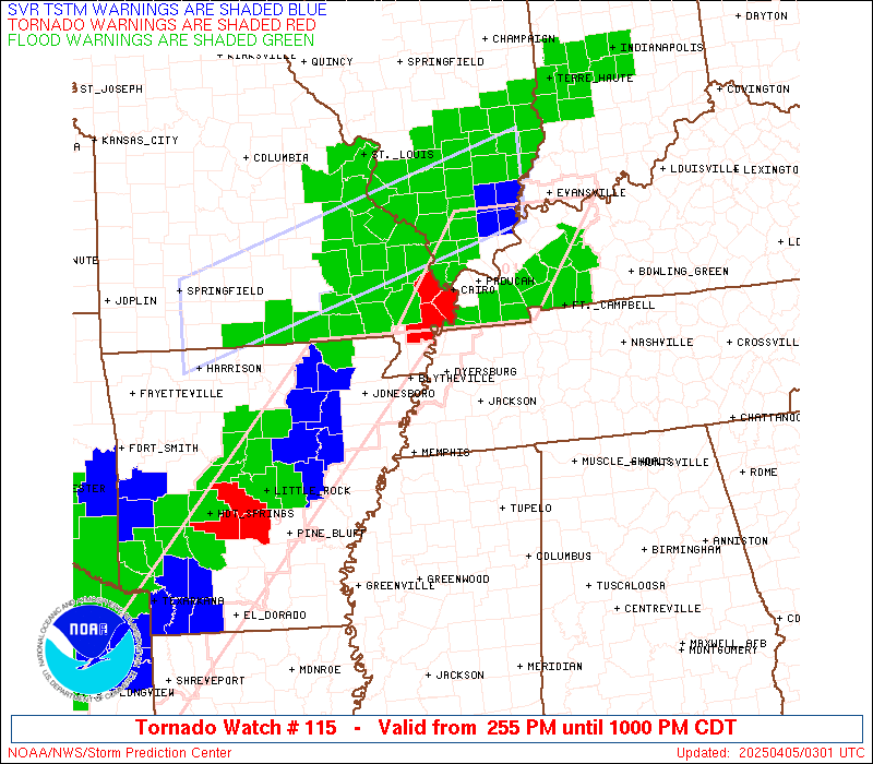
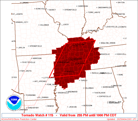
The tornado watch area is approximately along and 80 statute miles
east and west of a line from 30 miles east northeast of Paducah KY
to 25 miles south southwest of Memphis TN. For a complete depiction
of the watch see the associated watch outline update (WOUS64 KWNS
WOU5).
PRECAUTIONARY/PREPAREDNESS ACTIONS...
REMEMBER...A Tornado Watch means conditions are favorable for
tornadoes and severe thunderstorms in and close to the watch
area. Persons in these areas should be on the lookout for
threatening weather conditions and listen for later statements
and possible warnings.
&&
OTHER WATCH INFORMATION...CONTINUE...WW 113...WW 114...
AVIATION...Tornadoes and a few severe thunderstorms with hail
surface and aloft to 2 inches. Extreme turbulence and surface wind
gusts to 65 knots. A few cumulonimbi with maximum tops to 550. Mean
storm motion vector 24025.
...Thompson

   SEL5

   URGENT - IMMEDIATE BROADCAST REQUESTED
   Tornado Watch Number 115
   NWS Storm Prediction Center Norman OK
   255 PM CDT Fri Apr 4 2025

   The NWS Storm Prediction Center has issued a

   * Tornado Watch for portions of
     Northeast Arkansas
     Extreme southern Illinois
     Western Kentucky
     Southeast Missouri
     Norhern Mississippi
     Western and Middle Tennessee

   * Effective this Friday afternoon and evening from 255 PM until
     1000 PM CDT.

   * Primary threats include...
     A few tornadoes likely with a couple intense tornadoes possible
     Scattered damaging winds likely with isolated significant gusts
       to 75 mph possible
     Scattered large hail likely with isolated very large hail events
       to 2 inches in diameter possible

   SUMMARY...Widely scattered supercell development is expected this
   afternoon from northern Mississippi across western/Middle Tennessee
   into western Kentucky.  The storm environment supports the potential
   for several tornadoes (including an isolated strong tornado), large
   hail up to 2 inches in diameter, and isolated damaging gusts.  The
   potential for damaging winds up to 75 mph will increase later this
   evening into early tonight as storm clusters spread into southeast
   Missouri from Arkansas.

   The tornado watch area is approximately along and 80 statute miles
   east and west of a line from 30 miles east northeast of Paducah KY
   to 25 miles south southwest of Memphis TN. For a complete depiction
   of the watch see the associated watch outline update (WOUS64 KWNS
   WOU5).

   PRECAUTIONARY/PREPAREDNESS ACTIONS...

   REMEMBER...A Tornado Watch means conditions are favorable for
   tornadoes and severe thunderstorms in and close to the watch
   area. Persons in these areas should be on the lookout for
   threatening weather conditions and listen for later statements
   and possible warnings.

   &&

   OTHER WATCH INFORMATION...CONTINUE...WW 113...WW 114...

   AVIATION...Tornadoes and a few severe thunderstorms with hail
   surface and aloft to 2 inches. Extreme turbulence and surface wind
   gusts to 65 knots. A few cumulonimbi with maximum tops to 550. Mean
   storm motion vector 24025.

   ...Thompson
 Note:
The Aviation Watch (SAW) product is an approximation to the watch area.
The actual watch is depicted by the shaded areas.
Note:
The Aviation Watch (SAW) product is an approximation to the watch area.
The actual watch is depicted by the shaded areas.
   SAW5
   WW 115 TORNADO AR IL KY MO MS TN 041955Z - 050300Z
   AXIS..80 STATUTE MILES EAST AND WEST OF LINE..
   30ENE PAH/PADUCAH KY/ - 25SSW MEM/MEMPHIS TN/
   ..AVIATION COORDS.. 70NM E/W /48SSW PXV - 23SSW MEM/
   HAIL SURFACE AND ALOFT..2 INCHES. WIND GUSTS..65 KNOTS.
   MAX TOPS TO 550. MEAN STORM MOTION VECTOR 24025.

   LAT...LON 37238681 34708874 34709156 37238972

   THIS IS AN APPROXIMATION TO THE WATCH AREA.  FOR A
   COMPLETE DEPICTION OF THE WATCH SEE WOUS64 KWNS
   FOR WOU5.
Watch 115 Status Report Messages:
STATUS REPORT #4 ON WW 115

VALID 050050Z - 050140Z

SEVERE WEATHER THREAT CONTINUES RIGHT OF A LINE FROM 30 S OWB TO
30 ENE DYR TO 20 E MEM TO 35 ENE PBF.

..SUPINIE..04/05/25

ATTN...WFO...MEG...PAH...OHX...

&&

STATUS REPORT FOR WT 115

SEVERE WEATHER THREAT CONTINUES FOR THE FOLLOWING AREAS

ARC021-031-035-037-055-093-111-123-050140-

AR
.    ARKANSAS COUNTIES INCLUDED ARE

CLAY		     CRAIGHEAD		 CRITTENDEN
CROSS		     GREENE		 MISSISSIPPI
POINSETT	     ST. FRANCIS
$$


ILC003-059-069-077-087-127-151-153-165-181-199-050140-

IL
.    ILLINOIS COUNTIES INCLUDED ARE

ALEXANDER	     GALLATIN		 HARDIN
JACKSON 	     JOHNSON		 MASSAC
POPE		     PULASKI		 SALINE
UNION		     WILLIAMSON
$$


KYC007-033-035-039-055-075-083-105-107-139-143-145-157-050140-

KY
.    KENTUCKY COUNTIES INCLUDED ARE

BALLARD 	     CALDWELL		 CALLOWAY
CARLISLE	     CRITTENDEN 	 FULTON
GRAVES		     HICKMAN		 HOPKINS
LIVINGSTON	     LYON		 MCCRACKEN
MARSHALL
$$


MOC023-031-069-133-143-155-181-201-207-050140-

MO
.    MISSOURI COUNTIES INCLUDED ARE

BUTLER		     CAPE GIRARDEAU	 DUNKLIN
MISSISSIPPI	     NEW MADRID 	 PEMISCOT
RIPLEY		     SCOTT		 STODDARD
$$


TNC033-045-047-053-075-095-097-131-157-167-183-050140-

TN
.    TENNESSEE COUNTIES INCLUDED ARE

CROCKETT	     DYER		 FAYETTE
GIBSON		     HAYWOOD		 LAKE
LAUDERDALE	     OBION		 SHELBY
TIPTON		     WEAKLEY
$$


THE WATCH STATUS MESSAGE IS FOR GUIDANCE PURPOSES ONLY.  PLEASE
REFER TO WATCH COUNTY NOTIFICATION STATEMENTS FOR OFFICIAL
INFORMATION ON COUNTIES...INDEPENDENT CITIES AND MARINE ZONES
CLEARED FROM SEVERE THUNDERSTORM AND TORNADO WATCHES.
$$

STATUS REPORT #3 ON WW 115

VALID 042250Z - 042340Z

SEVERE WEATHER THREAT CONTINUES RIGHT OF A LINE FROM 25 SSE OWB
TO 30 ENE DYR TO 20 E MEM TO 35 ENE PBF.

..LYONS..04/04/25

ATTN...WFO...MEG...PAH...OHX...

&&

STATUS REPORT FOR WT 115

SEVERE WEATHER THREAT CONTINUES FOR THE FOLLOWING AREAS

ARC021-031-035-037-055-077-093-095-111-123-042340-

AR
.    ARKANSAS COUNTIES INCLUDED ARE

CLAY		     CRAIGHEAD		 CRITTENDEN
CROSS		     GREENE		 LEE
MISSISSIPPI	     MONROE		 POINSETT
ST. FRANCIS
$$


ILC003-059-069-077-087-127-151-153-165-181-199-042340-

IL
.    ILLINOIS COUNTIES INCLUDED ARE

ALEXANDER	     GALLATIN		 HARDIN
JACKSON 	     JOHNSON		 MASSAC
POPE		     PULASKI		 SALINE
UNION		     WILLIAMSON
$$


KYC007-033-035-039-055-075-083-105-107-139-143-145-157-042340-

KY
.    KENTUCKY COUNTIES INCLUDED ARE

BALLARD 	     CALDWELL		 CALLOWAY
CARLISLE	     CRITTENDEN 	 FULTON
GRAVES		     HICKMAN		 HOPKINS
LIVINGSTON	     LYON		 MCCRACKEN
MARSHALL
$$


MSC009-042340-

MS
.    MISSISSIPPI COUNTIES INCLUDED ARE

BENTON
$$


MOC023-031-069-133-143-155-181-201-207-042340-

MO
.    MISSOURI COUNTIES INCLUDED ARE

BUTLER		     CAPE GIRARDEAU	 DUNKLIN
MISSISSIPPI	     NEW MADRID 	 PEMISCOT
RIPLEY		     SCOTT		 STODDARD
$$


TNC033-045-047-053-075-095-097-131-157-167-183-042340-

TN
.    TENNESSEE COUNTIES INCLUDED ARE

CROCKETT	     DYER		 FAYETTE
GIBSON		     HAYWOOD		 LAKE
LAUDERDALE	     OBION		 SHELBY
TIPTON		     WEAKLEY
$$


THE WATCH STATUS MESSAGE IS FOR GUIDANCE PURPOSES ONLY.  PLEASE
REFER TO WATCH COUNTY NOTIFICATION STATEMENTS FOR OFFICIAL
INFORMATION ON COUNTIES...INDEPENDENT CITIES AND MARINE ZONES
CLEARED FROM SEVERE THUNDERSTORM AND TORNADO WATCHES.
$$

STATUS REPORT #2 ON WW 115

VALID 042150Z - 042240Z

THE SEVERE WEATHER THREAT CONTINUES ACROSS THE ENTIRE WATCH AREA.

..LYONS..04/04/25

ATTN...WFO...MEG...PAH...OHX...

&&

STATUS REPORT FOR WT 115

SEVERE WEATHER THREAT CONTINUES FOR THE FOLLOWING AREAS

ARC021-031-035-037-055-077-093-107-111-123-042240-

AR
.    ARKANSAS COUNTIES INCLUDED ARE

CLAY		     CRAIGHEAD		 CRITTENDEN
CROSS		     GREENE		 LEE
MISSISSIPPI	     PHILLIPS		 POINSETT
ST. FRANCIS
$$


ILC003-069-087-127-151-153-181-042240-

IL
.    ILLINOIS COUNTIES INCLUDED ARE

ALEXANDER	     HARDIN		 JOHNSON
MASSAC		     POPE		 PULASKI
UNION
$$


KYC007-033-035-039-047-055-075-083-105-107-139-143-145-157-177-
219-221-042240-

KY
.    KENTUCKY COUNTIES INCLUDED ARE

BALLARD 	     CALDWELL		 CALLOWAY
CARLISLE	     CHRISTIAN		 CRITTENDEN
FULTON		     GRAVES		 HICKMAN
HOPKINS 	     LIVINGSTON 	 LYON
MCCRACKEN	     MARSHALL		 MUHLENBERG
TODD		     TRIGG
$$


MSC003-009-027-033-071-093-107-117-119-135-137-139-141-143-145-
042240-

MS
.    MISSISSIPPI COUNTIES INCLUDED ARE

ALCORN		     BENTON		 COAHOMA
DESOTO		     LAFAYETTE		 MARSHALL
PANOLA		     PRENTISS		 QUITMAN
TALLAHATCHIE	     TATE		 TIPPAH
TISHOMINGO	     TUNICA		 UNION
$$


MOC023-069-133-143-155-181-201-207-042240-

MO
.    MISSOURI COUNTIES INCLUDED ARE

BUTLER		     DUNKLIN		 MISSISSIPPI
NEW MADRID	     PEMISCOT		 RIPLEY
SCOTT		     STODDARD
$$


TNC005-017-021-023-033-037-039-043-045-047-053-069-071-075-077-
079-081-083-085-095-097-101-109-113-119-125-131-135-147-157-161-
167-181-183-187-042240-

TN
.    TENNESSEE COUNTIES INCLUDED ARE

BENTON		     CARROLL		 CHEATHAM
CHESTER 	     CROCKETT		 DAVIDSON
DECATUR 	     DICKSON		 DYER
FAYETTE 	     GIBSON		 HARDEMAN
HARDIN		     HAYWOOD		 HENDERSON
HENRY		     HICKMAN		 HOUSTON
HUMPHREYS	     LAKE		 LAUDERDALE
LEWIS		     MCNAIRY		 MADISON
MAURY		     MONTGOMERY 	 OBION
PERRY		     ROBERTSON		 SHELBY
STEWART 	     TIPTON		 WAYNE
WEAKLEY 	     WILLIAMSON
$$


THE WATCH STATUS MESSAGE IS FOR GUIDANCE PURPOSES ONLY.  PLEASE
REFER TO WATCH COUNTY NOTIFICATION STATEMENTS FOR OFFICIAL
INFORMATION ON COUNTIES...INDEPENDENT CITIES AND MARINE ZONES
CLEARED FROM SEVERE THUNDERSTORM AND TORNADO WATCHES.
$$

STATUS REPORT #1 ON WW 115

VALID 042055Z - 042140Z

THE SEVERE WEATHER THREAT CONTINUES ACROSS THE ENTIRE WATCH AREA.

..LYONS..04/04/25

ATTN...WFO...MEG...PAH...OHX...

&&

STATUS REPORT FOR WT 115

SEVERE WEATHER THREAT CONTINUES FOR THE FOLLOWING AREAS

ARC021-031-035-037-055-077-093-107-111-123-042140-

AR
.    ARKANSAS COUNTIES INCLUDED ARE

CLAY		     CRAIGHEAD		 CRITTENDEN
CROSS		     GREENE		 LEE
MISSISSIPPI	     PHILLIPS		 POINSETT
ST. FRANCIS
$$


ILC003-069-087-127-151-153-181-042140-

IL
.    ILLINOIS COUNTIES INCLUDED ARE

ALEXANDER	     HARDIN		 JOHNSON
MASSAC		     POPE		 PULASKI
UNION
$$


KYC007-033-035-039-047-055-075-083-105-107-139-143-145-157-177-
219-221-042140-

KY
.    KENTUCKY COUNTIES INCLUDED ARE

BALLARD 	     CALDWELL		 CALLOWAY
CARLISLE	     CHRISTIAN		 CRITTENDEN
FULTON		     GRAVES		 HICKMAN
HOPKINS 	     LIVINGSTON 	 LYON
MCCRACKEN	     MARSHALL		 MUHLENBERG
TODD		     TRIGG
$$


MSC003-009-027-033-071-093-107-117-119-135-137-139-141-143-145-
042140-

MS
.    MISSISSIPPI COUNTIES INCLUDED ARE

ALCORN		     BENTON		 COAHOMA
DESOTO		     LAFAYETTE		 MARSHALL
PANOLA		     PRENTISS		 QUITMAN
TALLAHATCHIE	     TATE		 TIPPAH
TISHOMINGO	     TUNICA		 UNION
$$


MOC023-069-133-143-155-181-201-207-042140-

MO
.    MISSOURI COUNTIES INCLUDED ARE

BUTLER		     DUNKLIN		 MISSISSIPPI
NEW MADRID	     PEMISCOT		 RIPLEY
SCOTT		     STODDARD
$$


TNC005-017-021-023-033-037-039-043-045-047-053-069-071-075-077-
079-081-083-085-095-097-101-109-113-119-125-131-135-147-157-161-
167-181-183-187-042140-

TN
.    TENNESSEE COUNTIES INCLUDED ARE

BENTON		     CARROLL		 CHEATHAM
CHESTER 	     CROCKETT		 DAVIDSON
DECATUR 	     DICKSON		 DYER
FAYETTE 	     GIBSON		 HARDEMAN
HARDIN		     HAYWOOD		 HENDERSON
HENRY		     HICKMAN		 HOUSTON
HUMPHREYS	     LAKE		 LAUDERDALE
LEWIS		     MCNAIRY		 MADISON
MAURY		     MONTGOMERY 	 OBION
PERRY		     ROBERTSON		 SHELBY
STEWART 	     TIPTON		 WAYNE
WEAKLEY 	     WILLIAMSON
$$


THE WATCH STATUS MESSAGE IS FOR GUIDANCE PURPOSES ONLY.  PLEASE
REFER TO WATCH COUNTY NOTIFICATION STATEMENTS FOR OFFICIAL
INFORMATION ON COUNTIES...INDEPENDENT CITIES AND MARINE ZONES
CLEARED FROM SEVERE THUNDERSTORM AND TORNADO WATCHES.
$$
Note:
Click for Complete Product Text.
Tornadoes
Probability of 2 or more tornadoes
|
Mod (60%)
|
Probability of 1 or more strong (EF2-EF5) tornadoes
|
Mod (40%)
|
Wind
Probability of 10 or more severe wind events
|
Mod (60%)
|
Probability of 1 or more wind events > 65 knots
|
Mod (30%)
|
Hail
Probability of 10 or more severe hail events
|
Mod (60%)
|
Probability of 1 or more hailstones > 2 inches
|
Mod (50%)
|
Combined Severe Hail/Wind
Probability of 6 or more combined severe hail/wind events
|
High (>95%)
|
For each watch, probabilities for particular events inside the watch
(listed above in each table) are determined by the issuing forecaster.
The "Low" category contains probability values ranging from less than 2%
to 20% (EF2-EF5 tornadoes), less than 5% to 20% (all other probabilities),
"Moderate" from 30% to 60%, and "High" from 70% to greater than 95%.
High values are bolded and lighter in color to provide awareness of
an increased threat for a particular event.


 @NWSSPC