Note:
The expiration time in the watch graphic is amended if the watch is
replaced, cancelled or extended.
Note:
Note:
The expiration time in the watch graphic is amended if the watch is
replaced, cancelled or extended.
Note: Click for
Watch Status Reports.
SEL7
URGENT - IMMEDIATE BROADCAST REQUESTED
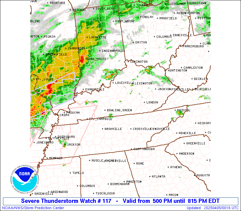
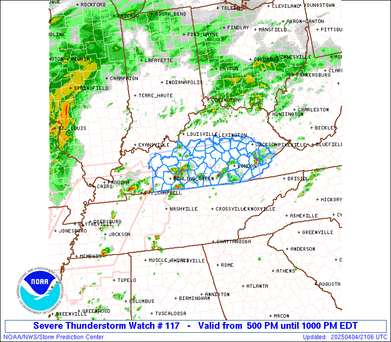
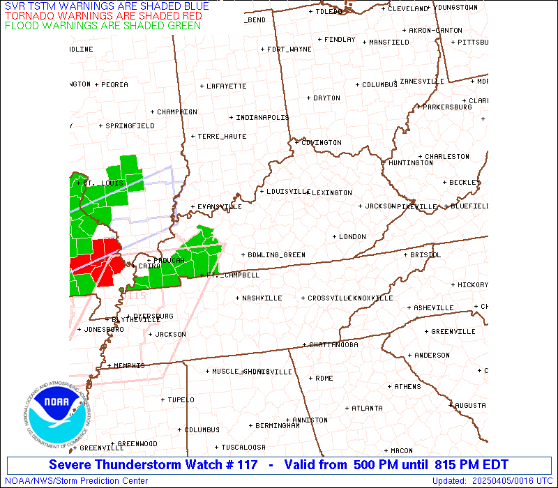
Severe Thunderstorm Watch Number 117
NWS Storm Prediction Center Norman OK
500 PM EDT Fri Apr 4 2025
The NWS Storm Prediction Center has issued a
* Severe Thunderstorm Watch for portions of
South central and southeast Kentucky
* Effective this Friday afternoon and evening from 500 PM until
1000 PM EDT.
* Primary threats include...
Scattered large hail and isolated very large hail events to 2
inches in diameter possible
Scattered damaging wind gusts to 70 mph possible
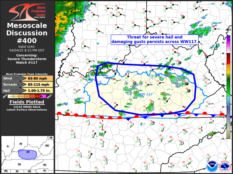
SUMMARY...Isolated warm sector supercells will persist through the
afternoon/evening with the potential to produce large hail of 1-2
inches in diameter and isolated damaging gusts of 60-70 mph.
The severe thunderstorm watch area is approximately along and 40
statute miles north and south of a line from 35 miles west northwest
of Bowling Green KY to 25 miles south southeast of Jackson KY. For a
complete depiction of the watch see the associated watch outline
update (WOUS64 KWNS WOU7).
PRECAUTIONARY/PREPAREDNESS ACTIONS...
REMEMBER...A Severe Thunderstorm Watch means conditions are
favorable for severe thunderstorms in and close to the watch area.
Persons in these areas should be on the lookout for threatening
weather conditions and listen for later statements and possible
warnings. Severe thunderstorms can and occasionally do produce
tornadoes.
&&
OTHER WATCH INFORMATION...CONTINUE...WW 113...WW 114...WW
115...WW 116...
AVIATION...A few severe thunderstorms with hail surface and aloft to
2 inches. Extreme turbulence and surface wind gusts to 60 knots. A
few cumulonimbi with maximum tops to 500. Mean storm motion vector
25025.
...Thompson
 Note:
The Aviation Watch (SAW) product is an approximation to the watch area.
The actual watch is depicted by the shaded areas.
Note:
The Aviation Watch (SAW) product is an approximation to the watch area.
The actual watch is depicted by the shaded areas.
SAW7
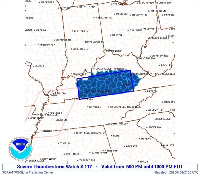
WW 117 SEVERE TSTM KY 042100Z - 050200Z
AXIS..40 STATUTE MILES NORTH AND SOUTH OF LINE..
35WNW BWG/BOWLING GREEN KY/ - 25SSE JKL/JACKSON KY/
..AVIATION COORDS.. 35NM N/S /31WNW BWG - 45ENE LOZ/
HAIL SURFACE AND ALOFT..2 INCHES. WIND GUSTS..60 KNOTS.
MAX TOPS TO 500. MEAN STORM MOTION VECTOR 25025.
LAT...LON 37748701 37788321 36638321 36588701
THIS IS AN APPROXIMATION TO THE WATCH AREA. FOR A
COMPLETE DEPICTION OF THE WATCH SEE WOUS64 KWNS
FOR WOU7.
Watch 117 Status Report Messages:
STATUS REPORT #2 ON WW 117

VALID 042305Z - 050040Z

SEVERE WEATHER THREAT CONTINUES RIGHT OF A LINE FROM 55 NNW CSV
TO 25 E LEX.

..LYONS..04/04/25

ATTN...WFO...LMK...JKL...

&&

STATUS REPORT FOR WS 117

SEVERE WEATHER THREAT CONTINUES FOR THE FOLLOWING AREAS

KYC013-025-045-051-053-065-095-109-119-121-125-129-131-133-147-
151-189-193-197-199-203-207-231-235-237-050040-

KY
.    KENTUCKY COUNTIES INCLUDED ARE

BELL		     BREATHITT		 CASEY
CLAY		     CLINTON		 ESTILL
HARLAN		     JACKSON		 KNOTT
KNOX		     LAUREL		 LEE
LESLIE		     LETCHER		 MCCREARY
MADISON 	     OWSLEY		 PERRY
POWELL		     PULASKI		 ROCKCASTLE
RUSSELL 	     WAYNE		 WHITLEY
WOLFE
$$


THE WATCH STATUS MESSAGE IS FOR GUIDANCE PURPOSES ONLY.  PLEASE
REFER TO WATCH COUNTY NOTIFICATION STATEMENTS FOR OFFICIAL
INFORMATION ON COUNTIES...INDEPENDENT CITIES AND MARINE ZONES
CLEARED FROM SEVERE THUNDERSTORM AND TORNADO WATCHES.
$$

STATUS REPORT #1 ON WW 117

VALID 042145Z - 042240Z

THE SEVERE WEATHER THREAT CONTINUES ACROSS THE ENTIRE WATCH AREA.

..LYONS..04/04/25

ATTN...WFO...LMK...JKL...

&&

STATUS REPORT FOR WS 117

SEVERE WEATHER THREAT CONTINUES FOR THE FOLLOWING AREAS

KYC001-003-009-013-021-025-031-045-051-053-057-061-065-079-085-
087-093-095-099-109-113-119-121-123-125-129-131-133-137-141-147-
151-155-167-169-171-179-183-189-193-197-199-203-207-213-217-227-
229-231-235-237-042240-

KY
.    KENTUCKY COUNTIES INCLUDED ARE

ADAIR		     ALLEN		 BARREN
BELL		     BOYLE		 BREATHITT
BUTLER		     CASEY		 CLAY
CLINTON 	     CUMBERLAND 	 EDMONSON
ESTILL		     GARRARD		 GRAYSON
GREEN		     HARDIN		 HARLAN
HART		     JACKSON		 JESSAMINE
KNOTT		     KNOX		 LARUE
LAUREL		     LEE		 LESLIE
LETCHER 	     LINCOLN		 LOGAN
MCCREARY	     MADISON		 MARION
MERCER		     METCALFE		 MONROE
NELSON		     OHIO		 OWSLEY
PERRY		     POWELL		 PULASKI
ROCKCASTLE	     RUSSELL		 SIMPSON
TAYLOR		     WARREN		 WASHINGTON
WAYNE		     WHITLEY		 WOLFE
$$


THE WATCH STATUS MESSAGE IS FOR GUIDANCE PURPOSES ONLY.  PLEASE
REFER TO WATCH COUNTY NOTIFICATION STATEMENTS FOR OFFICIAL
INFORMATION ON COUNTIES...INDEPENDENT CITIES AND MARINE ZONES
CLEARED FROM SEVERE THUNDERSTORM AND TORNADO WATCHES.
$$
Note:
Click for Complete Product Text.
Tornadoes
Probability of 2 or more tornadoes
|
Low (10%)
|
Probability of 1 or more strong (EF2-EF5) tornadoes
|
Low (5%)
|
Wind
Probability of 10 or more severe wind events
|
Mod (40%)
|
Probability of 1 or more wind events > 65 knots
|
Low (20%)
|
Hail
Probability of 10 or more severe hail events
|
Mod (40%)
|
Probability of 1 or more hailstones > 2 inches
|
Mod (30%)
|
Combined Severe Hail/Wind
Probability of 6 or more combined severe hail/wind events
|
High (70%)
|
For each watch, probabilities for particular events inside the watch
(listed above in each table) are determined by the issuing forecaster.
The "Low" category contains probability values ranging from less than 2%
to 20% (EF2-EF5 tornadoes), less than 5% to 20% (all other probabilities),
"Moderate" from 30% to 60%, and "High" from 70% to greater than 95%.
High values are bolded and lighter in color to provide awareness of
an increased threat for a particular event.


 @NWSSPC