 Note:
The expiration time in the watch graphic is amended if the watch is
replaced, cancelled or extended.
Note:
Note:
The expiration time in the watch graphic is amended if the watch is
replaced, cancelled or extended.
Note: Click for
Watch Status Reports.
SEL7
URGENT - IMMEDIATE BROADCAST REQUESTED
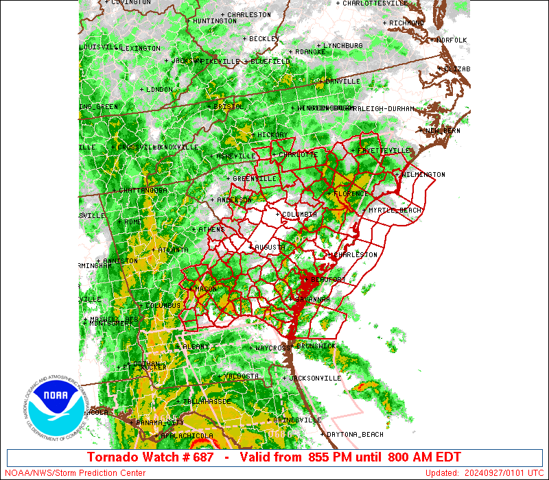
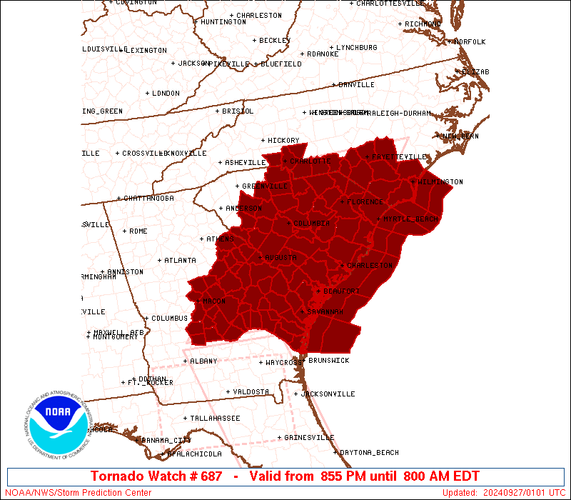
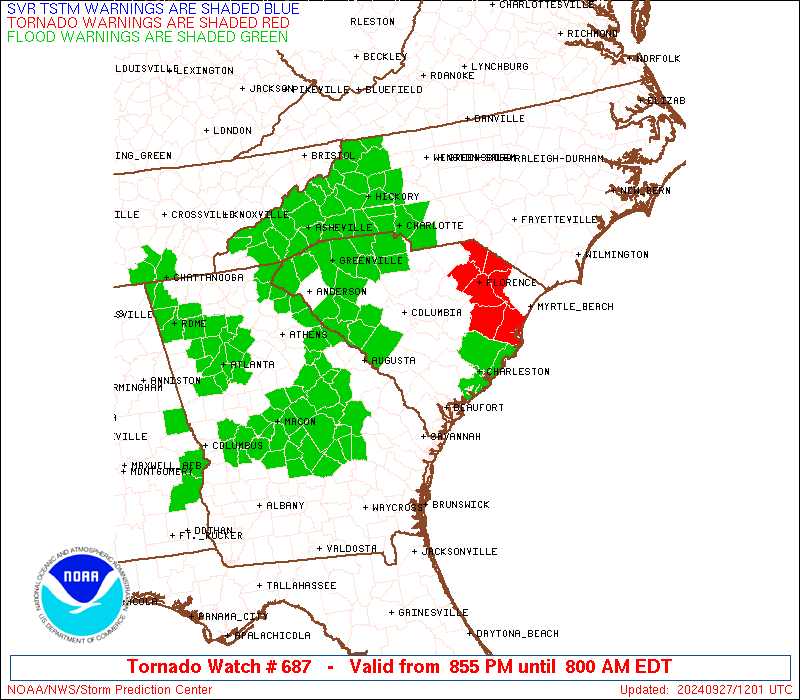
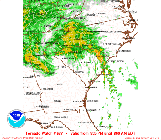
Tornado Watch Number 687
NWS Storm Prediction Center Norman OK
855 PM EDT Thu Sep 26 2024
The NWS Storm Prediction Center has issued a
* Tornado Watch for portions of
Central and Eastern Georgia
Southern North Carolina
South Carolina
Coastal Waters
* Effective this Thursday night and Friday morning from 855 PM
until 800 AM EDT.
* Primary threats include...
Several tornadoes likely
SUMMARY...Low-topped thunderstorms associated with Hurricane Helene
will pose a threat for several tornadoes this evening through much
of the overnight period, and continuing into early Friday morning.
The tornado watch area is approximately along and 100 statute miles
east and west of a line from 20 miles south of Vidalia GA to 40
miles west northwest of Fayetteville NC. For a complete depiction of
the watch see the associated watch outline update (WOUS64 KWNS
WOU7).
PRECAUTIONARY/PREPAREDNESS ACTIONS...
REMEMBER...A Tornado Watch means conditions are favorable for
tornadoes and severe thunderstorms in and close to the watch
area. Persons in these areas should be on the lookout for
threatening weather conditions and listen for later statements
and possible warnings.
&&
OTHER WATCH INFORMATION...CONTINUE...WW 684...WW 685...WW 686...
AVIATION...Tornadoes and a few severe thunderstorms with hail
surface and aloft to 0.5 inches. Extreme turbulence and surface wind
gusts to 60 knots. A few cumulonimbi with maximum tops to 500. Mean
storm motion vector 18050.
...Gleason
   SEL7

   URGENT - IMMEDIATE BROADCAST REQUESTED
   Tornado Watch Number 687
   NWS Storm Prediction Center Norman OK
   855 PM EDT Thu Sep 26 2024

   The NWS Storm Prediction Center has issued a

   * Tornado Watch for portions of
     Central and Eastern Georgia
     Southern North Carolina
     South Carolina
     Coastal Waters

   * Effective this Thursday night and Friday morning from 855 PM
     until 800 AM EDT.

   * Primary threats include...
     Several tornadoes likely

   SUMMARY...Low-topped thunderstorms associated with Hurricane Helene
   will pose a threat for several tornadoes this evening through much
   of the overnight period, and continuing into early Friday morning.

   The tornado watch area is approximately along and 100 statute miles
   east and west of a line from 20 miles south of Vidalia GA to 40
   miles west northwest of Fayetteville NC. For a complete depiction of
   the watch see the associated watch outline update (WOUS64 KWNS
   WOU7).

   PRECAUTIONARY/PREPAREDNESS ACTIONS...

   REMEMBER...A Tornado Watch means conditions are favorable for
   tornadoes and severe thunderstorms in and close to the watch
   area. Persons in these areas should be on the lookout for
   threatening weather conditions and listen for later statements
   and possible warnings.

   &&

   OTHER WATCH INFORMATION...CONTINUE...WW 684...WW 685...WW 686...

   AVIATION...Tornadoes and a few severe thunderstorms with hail
   surface and aloft to 0.5 inches. Extreme turbulence and surface wind
   gusts to 60 knots. A few cumulonimbi with maximum tops to 500. Mean
   storm motion vector 18050.

   ...Gleason
 Note:
The Aviation Watch (SAW) product is an approximation to the watch area.
The actual watch is depicted by the shaded areas.
Note:
The Aviation Watch (SAW) product is an approximation to the watch area.
The actual watch is depicted by the shaded areas.
   SAW7
   WW 687 TORNADO GA NC SC CW 270055Z - 271200Z
   AXIS..100 STATUTE MILES EAST AND WEST OF LINE..
   20S VDI/VIDALIA GA/ - 40WNW FAY/FAYETTEVILLE NC/
   ..AVIATION COORDS.. 85NM E/W /23NNE AMG - 55SW RDU/
   HAIL SURFACE AND ALOFT..0.5 INCH. WIND GUSTS..60 KNOTS.
   MAX TOPS TO 500. MEAN STORM MOTION VECTOR 18050.

   LAT...LON 31898407 35188131 35187776 31898067

   THIS IS AN APPROXIMATION TO THE WATCH AREA.  FOR A
   COMPLETE DEPICTION OF THE WATCH SEE WOUS64 KWNS
   FOR WOU7.
Watch 687 Status Report Messages:
STATUS REPORT #4 ON WW 687

VALID 270930Z - 271040Z

SEVERE WEATHER THREAT CONTINUES RIGHT OF A LINE FROM 30 N MCN TO
30 W VDI TO 25 SE VDI TO 70 ESE SAV.

..BROYLES..09/27/24

ATTN...WFO...FFC...CHS...CAE...RAH...ILM...GSP...

&&

STATUS REPORT FOR WT 687

SEVERE WEATHER THREAT CONTINUES FOR THE FOLLOWING AREAS

GAC009-033-051-073-103-107-125-141-163-165-167-175-181-189-245-
251-265-279-283-301-303-317-319-271040-

GA
.    GEORGIA COUNTIES INCLUDED ARE

BALDWIN 	     BURKE		 CHATHAM
COLUMBIA	     EFFINGHAM		 EMANUEL
GLASCOCK	     HANCOCK		 JEFFERSON
JENKINS 	     JOHNSON		 LAURENS
LINCOLN 	     MCDUFFIE		 RICHMOND
SCREVEN 	     TALIAFERRO 	 TOOMBS
TREUTLEN	     WARREN		 WASHINGTON
WILKES		     WILKINSON
$$


NCC007-017-019-025-047-051-071-093-119-129-141-153-155-163-165-
179-271040-

NC
.    NORTH CAROLINA COUNTIES INCLUDED ARE

ANSON		     BLADEN		 BRUNSWICK
CABARRUS	     COLUMBUS		 CUMBERLAND
GASTON		     HOKE		 MECKLENBURG
NEW HANOVER	     PENDER		 RICHMOND
ROBESON 	     SAMPSON		 SCOTLAND
UNION
$$


SCC003-005-009-011-013-015-017-019-023-025-027-029-031-033-035-
037-039-041-043-047-049-051-053-055-057-059-061-063-065-067-069-
071-075-079-081-085-087-089-091-271040-

SC
.    SOUTH CAROLINA COUNTIES INCLUDED ARE

AIKEN		     ALLENDALE		 BAMBERG
BARNWELL	     BEAUFORT		 BERKELEY
CALHOUN 	     CHARLESTON 	 CHESTER
CHESTERFIELD	     CLARENDON		 COLLETON
DARLINGTON	     DILLON		 DORCHESTER
EDGEFIELD	     FAIRFIELD		 FLORENCE
GEORGETOWN	     GREENWOOD		 HAMPTON
HORRY		     JASPER		 KERSHAW
LANCASTER	     LAURENS		 LEE
LEXINGTON	     MCCORMICK		 MARION
MARLBORO	     NEWBERRY		 ORANGEBURG
RICHLAND	     SALUDA		 SUMTER
UNION		     WILLIAMSBURG	 YORK
$$


AMZ250-252-254-256-270-272-274-276-330-350-352-370-372-271040-

CW

.    ADJACENT COASTAL WATERS INCLUDED ARE

COASTAL WATERS FROM SURF CITY TO CAPE FEAR NC OUT 20 NM

COASTAL WATERS FROM CAPE FEAR NC TO LITTLE RIVER INLET SC OUT 20
NM

COASTAL WATERS FROM LITTLE RIVER INLET TO MURRELLS INLET SC OUT
20 NM

COASTAL WATERS FROM MURRELLS INLET TO SOUTH SANTEE RIVER SC OUT
20 NM

WATERS FROM SURF CITY TO CAPE FEAR NC FROM 20 TO 40 NM

WATERS FROM CAPE FEAR NC TO LITTLE RIVER INLET SC FROM 20 TO 40
NM

WATERS FROM LITTLE RIVER INLET TO MURRELLS INLET SC FROM 20 TO 40
NM

WATERS FROM MURRELLS INLET NC TO SOUTH SANTEE RIVER SC FROM 20 TO
40 NM

CHARLESTON HARBOR

COASTAL WATERS FROM SOUTH SANTEE RIVER TO EDISTO BEACH SC OUT 20
NM

COASTAL WATERS FROM EDISTO BEACH SC TO SAVANNAH GA OUT 20 NM

WATERS FROM SOUTH SANTEE RIVER SC TO EDISTO BEACH SC EXTENDING
FROM 20 NM TO 40 NM

WATERS FROM EDISTO BEACH SC TO SAVANNAH GA EXTENDING FROM 20 NM
TO 40 NM

$$
THE WATCH STATUS MESSAGE IS FOR GUIDANCE PURPOSES ONLY.  PLEASE
REFER TO WATCH COUNTY NOTIFICATION STATEMENTS FOR OFFICIAL
INFORMATION ON COUNTIES...INDEPENDENT CITIES AND MARINE ZONES
CLEARED FROM SEVERE THUNDERSTORM AND TORNADO WATCHES.
$$

STATUS REPORT #3 ON WW 687

VALID 270835Z - 270940Z

THE SEVERE WEATHER THREAT CONTINUES ACROSS THE ENTIRE WATCH AREA.

..BROYLES..09/27/24

ATTN...WFO...FFC...CHS...CAE...RAH...ILM...GSP...

&&

STATUS REPORT FOR WT 687

SEVERE WEATHER THREAT CONTINUES FOR THE FOLLOWING AREAS

GAC009-021-023-029-031-033-043-051-073-081-091-093-103-107-109-
125-141-153-163-165-167-169-175-179-181-183-189-191-209-235-245-
251-265-267-271-279-283-289-301-303-309-315-317-319-270940-

GA
.    GEORGIA COUNTIES INCLUDED ARE

BALDWIN 	     BIBB		 BLECKLEY
BRYAN		     BULLOCH		 BURKE
CANDLER 	     CHATHAM		 COLUMBIA
CRISP		     DODGE		 DOOLY
EFFINGHAM	     EMANUEL		 EVANS
GLASCOCK	     HANCOCK		 HOUSTON
JEFFERSON	     JENKINS		 JOHNSON
JONES		     LAURENS		 LIBERTY
LINCOLN 	     LONG		 MCDUFFIE
MCINTOSH	     MONTGOMERY 	 PULASKI
RICHMOND	     SCREVEN		 TALIAFERRO
TATTNALL	     TELFAIR		 TOOMBS
TREUTLEN	     TWIGGS		 WARREN
WASHINGTON	     WHEELER		 WILCOX
WILKES		     WILKINSON
$$


NCC007-017-019-025-047-051-071-093-119-129-141-153-155-163-165-
179-270940-

NC
.    NORTH CAROLINA COUNTIES INCLUDED ARE

ANSON		     BLADEN		 BRUNSWICK
CABARRUS	     COLUMBUS		 CUMBERLAND
GASTON		     HOKE		 MECKLENBURG
NEW HANOVER	     PENDER		 RICHMOND
ROBESON 	     SAMPSON		 SCOTLAND
UNION
$$


SCC003-005-009-011-013-015-017-019-023-025-027-029-031-033-035-
037-039-041-043-047-049-051-053-055-057-059-061-063-065-067-069-
071-075-079-081-085-087-089-091-270940-

SC
.    SOUTH CAROLINA COUNTIES INCLUDED ARE

AIKEN		     ALLENDALE		 BAMBERG
BARNWELL	     BEAUFORT		 BERKELEY
CALHOUN 	     CHARLESTON 	 CHESTER
CHESTERFIELD	     CLARENDON		 COLLETON
DARLINGTON	     DILLON		 DORCHESTER
EDGEFIELD	     FAIRFIELD		 FLORENCE
GEORGETOWN	     GREENWOOD		 HAMPTON
HORRY		     JASPER		 KERSHAW
LANCASTER	     LAURENS		 LEE
LEXINGTON	     MCCORMICK		 MARION
MARLBORO	     NEWBERRY		 ORANGEBURG
RICHLAND	     SALUDA		 SUMTER
UNION		     WILLIAMSBURG	 YORK
$$


AMZ250-252-254-256-270-272-274-276-330-350-352-354-370-372-374-
270940-

CW

.    ADJACENT COASTAL WATERS INCLUDED ARE

COASTAL WATERS FROM SURF CITY TO CAPE FEAR NC OUT 20 NM

COASTAL WATERS FROM CAPE FEAR NC TO LITTLE RIVER INLET SC OUT 20
NM

COASTAL WATERS FROM LITTLE RIVER INLET TO MURRELLS INLET SC OUT
20 NM

COASTAL WATERS FROM MURRELLS INLET TO SOUTH SANTEE RIVER SC OUT
20 NM

WATERS FROM SURF CITY TO CAPE FEAR NC FROM 20 TO 40 NM

WATERS FROM CAPE FEAR NC TO LITTLE RIVER INLET SC FROM 20 TO 40
NM

WATERS FROM LITTLE RIVER INLET TO MURRELLS INLET SC FROM 20 TO 40
NM

WATERS FROM MURRELLS INLET NC TO SOUTH SANTEE RIVER SC FROM 20 TO
40 NM

CHARLESTON HARBOR

COASTAL WATERS FROM SOUTH SANTEE RIVER TO EDISTO BEACH SC OUT 20
NM

COASTAL WATERS FROM EDISTO BEACH SC TO SAVANNAH GA OUT 20 NM

COASTAL WATERS FROM SAVANNAH GA TO ALTAMAHA SOUND GA OUT 20 NM
...INCLUDING GRAYS REEF NATIONAL MARINE SANCTUARY

WATERS FROM SOUTH SANTEE RIVER SC TO EDISTO BEACH SC EXTENDING
FROM 20 NM TO 40 NM

WATERS FROM EDISTO BEACH SC TO SAVANNAH GA EXTENDING FROM 20 NM
TO 40 NM

WATERS FROM SAVANNAH GA TO ALTAMAHA SOUND GA EXTENDING FROM 20 NM
TO 60 NM

$$
THE WATCH STATUS MESSAGE IS FOR GUIDANCE PURPOSES ONLY.  PLEASE
REFER TO WATCH COUNTY NOTIFICATION STATEMENTS FOR OFFICIAL
INFORMATION ON COUNTIES...INDEPENDENT CITIES AND MARINE ZONES
CLEARED FROM SEVERE THUNDERSTORM AND TORNADO WATCHES.
$$

STATUS REPORT #2 ON WW 687

VALID 270540Z - 270640Z

THE SEVERE WEATHER THREAT CONTINUES ACROSS THE ENTIRE WATCH AREA.

..BROYLES..09/27/24

ATTN...WFO...FFC...CHS...CAE...RAH...ILM...GSP...

&&

STATUS REPORT FOR WT 687

SEVERE WEATHER THREAT CONTINUES FOR THE FOLLOWING AREAS

GAC009-021-023-029-031-033-043-051-073-081-091-093-103-107-109-
125-141-153-163-165-167-169-175-179-181-183-189-191-209-235-245-
251-265-267-271-279-283-289-301-303-309-315-317-319-270640-

GA
.    GEORGIA COUNTIES INCLUDED ARE

BALDWIN 	     BIBB		 BLECKLEY
BRYAN		     BULLOCH		 BURKE
CANDLER 	     CHATHAM		 COLUMBIA
CRISP		     DODGE		 DOOLY
EFFINGHAM	     EMANUEL		 EVANS
GLASCOCK	     HANCOCK		 HOUSTON
JEFFERSON	     JENKINS		 JOHNSON
JONES		     LAURENS		 LIBERTY
LINCOLN 	     LONG		 MCDUFFIE
MCINTOSH	     MONTGOMERY 	 PULASKI
RICHMOND	     SCREVEN		 TALIAFERRO
TATTNALL	     TELFAIR		 TOOMBS
TREUTLEN	     TWIGGS		 WARREN
WASHINGTON	     WHEELER		 WILCOX
WILKES		     WILKINSON
$$


NCC007-017-019-025-047-051-071-093-119-129-141-153-155-163-165-
179-270640-

NC
.    NORTH CAROLINA COUNTIES INCLUDED ARE

ANSON		     BLADEN		 BRUNSWICK
CABARRUS	     COLUMBUS		 CUMBERLAND
GASTON		     HOKE		 MECKLENBURG
NEW HANOVER	     PENDER		 RICHMOND
ROBESON 	     SAMPSON		 SCOTLAND
UNION
$$


SCC003-005-009-011-013-015-017-019-023-025-027-029-031-033-035-
037-039-041-043-047-049-051-053-055-057-059-061-063-065-067-069-
071-075-079-081-085-087-089-091-270640-

SC
.    SOUTH CAROLINA COUNTIES INCLUDED ARE

AIKEN		     ALLENDALE		 BAMBERG
BARNWELL	     BEAUFORT		 BERKELEY
CALHOUN 	     CHARLESTON 	 CHESTER
CHESTERFIELD	     CLARENDON		 COLLETON
DARLINGTON	     DILLON		 DORCHESTER
EDGEFIELD	     FAIRFIELD		 FLORENCE
GEORGETOWN	     GREENWOOD		 HAMPTON
HORRY		     JASPER		 KERSHAW
LANCASTER	     LAURENS		 LEE
LEXINGTON	     MCCORMICK		 MARION
MARLBORO	     NEWBERRY		 ORANGEBURG
RICHLAND	     SALUDA		 SUMTER
UNION		     WILLIAMSBURG	 YORK
$$


AMZ250-252-254-256-270-272-274-276-330-350-352-354-370-372-374-
270640-

CW

.    ADJACENT COASTAL WATERS INCLUDED ARE

COASTAL WATERS FROM SURF CITY TO CAPE FEAR NC OUT 20 NM

COASTAL WATERS FROM CAPE FEAR NC TO LITTLE RIVER INLET SC OUT 20
NM

COASTAL WATERS FROM LITTLE RIVER INLET TO MURRELLS INLET SC OUT
20 NM

COASTAL WATERS FROM MURRELLS INLET TO SOUTH SANTEE RIVER SC OUT
20 NM

WATERS FROM SURF CITY TO CAPE FEAR NC FROM 20 TO 40 NM

WATERS FROM CAPE FEAR NC TO LITTLE RIVER INLET SC FROM 20 TO 40
NM

WATERS FROM LITTLE RIVER INLET TO MURRELLS INLET SC FROM 20 TO 40
NM

WATERS FROM MURRELLS INLET NC TO SOUTH SANTEE RIVER SC FROM 20 TO
40 NM

CHARLESTON HARBOR

COASTAL WATERS FROM SOUTH SANTEE RIVER TO EDISTO BEACH SC OUT 20
NM

COASTAL WATERS FROM EDISTO BEACH SC TO SAVANNAH GA OUT 20 NM

COASTAL WATERS FROM SAVANNAH GA TO ALTAMAHA SOUND GA OUT 20 NM
...INCLUDING GRAYS REEF NATIONAL MARINE SANCTUARY

WATERS FROM SOUTH SANTEE RIVER SC TO EDISTO BEACH SC EXTENDING
FROM 20 NM TO 40 NM

WATERS FROM EDISTO BEACH SC TO SAVANNAH GA EXTENDING FROM 20 NM
TO 40 NM

WATERS FROM SAVANNAH GA TO ALTAMAHA SOUND GA EXTENDING FROM 20 NM
TO 60 NM

$$
THE WATCH STATUS MESSAGE IS FOR GUIDANCE PURPOSES ONLY.  PLEASE
REFER TO WATCH COUNTY NOTIFICATION STATEMENTS FOR OFFICIAL
INFORMATION ON COUNTIES...INDEPENDENT CITIES AND MARINE ZONES
CLEARED FROM SEVERE THUNDERSTORM AND TORNADO WATCHES.
$$

STATUS REPORT #1 ON WW 687

VALID 270320Z - 270440Z

THE SEVERE WEATHER THREAT CONTINUES ACROSS THE ENTIRE WATCH AREA.

..JEWELL..09/27/24

ATTN...WFO...FFC...CHS...CAE...RAH...ILM...GSP...

&&

STATUS REPORT FOR WT 687

SEVERE WEATHER THREAT CONTINUES FOR THE FOLLOWING AREAS

GAC009-021-023-029-031-033-043-051-073-081-091-093-103-107-109-
125-141-153-163-165-167-169-175-179-181-183-189-191-209-235-245-
251-265-267-271-279-283-289-301-303-309-315-317-319-270440-

GA
.    GEORGIA COUNTIES INCLUDED ARE

BALDWIN 	     BIBB		 BLECKLEY
BRYAN		     BULLOCH		 BURKE
CANDLER 	     CHATHAM		 COLUMBIA
CRISP		     DODGE		 DOOLY
EFFINGHAM	     EMANUEL		 EVANS
GLASCOCK	     HANCOCK		 HOUSTON
JEFFERSON	     JENKINS		 JOHNSON
JONES		     LAURENS		 LIBERTY
LINCOLN 	     LONG		 MCDUFFIE
MCINTOSH	     MONTGOMERY 	 PULASKI
RICHMOND	     SCREVEN		 TALIAFERRO
TATTNALL	     TELFAIR		 TOOMBS
TREUTLEN	     TWIGGS		 WARREN
WASHINGTON	     WHEELER		 WILCOX
WILKES		     WILKINSON
$$


NCC007-017-019-025-047-051-071-093-119-129-141-153-155-163-165-
179-270440-

NC
.    NORTH CAROLINA COUNTIES INCLUDED ARE

ANSON		     BLADEN		 BRUNSWICK
CABARRUS	     COLUMBUS		 CUMBERLAND
GASTON		     HOKE		 MECKLENBURG
NEW HANOVER	     PENDER		 RICHMOND
ROBESON 	     SAMPSON		 SCOTLAND
UNION
$$


SCC003-005-009-011-013-015-017-019-023-025-027-029-031-033-035-
037-039-041-043-047-049-051-053-055-057-059-061-063-065-067-069-
071-075-079-081-085-087-089-091-270440-

SC
.    SOUTH CAROLINA COUNTIES INCLUDED ARE

AIKEN		     ALLENDALE		 BAMBERG
BARNWELL	     BEAUFORT		 BERKELEY
CALHOUN 	     CHARLESTON 	 CHESTER
CHESTERFIELD	     CLARENDON		 COLLETON
DARLINGTON	     DILLON		 DORCHESTER
EDGEFIELD	     FAIRFIELD		 FLORENCE
GEORGETOWN	     GREENWOOD		 HAMPTON
HORRY		     JASPER		 KERSHAW
LANCASTER	     LAURENS		 LEE
LEXINGTON	     MCCORMICK		 MARION
MARLBORO	     NEWBERRY		 ORANGEBURG
RICHLAND	     SALUDA		 SUMTER
UNION		     WILLIAMSBURG	 YORK
$$


AMZ250-252-254-256-270-272-274-276-330-350-352-354-370-372-374-
270440-

CW

.    ADJACENT COASTAL WATERS INCLUDED ARE

COASTAL WATERS FROM SURF CITY TO CAPE FEAR NC OUT 20 NM

COASTAL WATERS FROM CAPE FEAR NC TO LITTLE RIVER INLET SC OUT 20
NM

COASTAL WATERS FROM LITTLE RIVER INLET TO MURRELLS INLET SC OUT
20 NM

COASTAL WATERS FROM MURRELLS INLET TO SOUTH SANTEE RIVER SC OUT
20 NM

WATERS FROM SURF CITY TO CAPE FEAR NC FROM 20 TO 40 NM

WATERS FROM CAPE FEAR NC TO LITTLE RIVER INLET SC FROM 20 TO 40
NM

WATERS FROM LITTLE RIVER INLET TO MURRELLS INLET SC FROM 20 TO 40
NM

WATERS FROM MURRELLS INLET NC TO SOUTH SANTEE RIVER SC FROM 20 TO
40 NM

CHARLESTON HARBOR

COASTAL WATERS FROM SOUTH SANTEE RIVER TO EDISTO BEACH SC OUT 20
NM

COASTAL WATERS FROM EDISTO BEACH SC TO SAVANNAH GA OUT 20 NM

COASTAL WATERS FROM SAVANNAH GA TO ALTAMAHA SOUND GA OUT 20 NM
...INCLUDING GRAYS REEF NATIONAL MARINE SANCTUARY

WATERS FROM SOUTH SANTEE RIVER SC TO EDISTO BEACH SC EXTENDING
FROM 20 NM TO 40 NM

WATERS FROM EDISTO BEACH SC TO SAVANNAH GA EXTENDING FROM 20 NM
TO 40 NM

WATERS FROM SAVANNAH GA TO ALTAMAHA SOUND GA EXTENDING FROM 20 NM
TO 60 NM

$$
THE WATCH STATUS MESSAGE IS FOR GUIDANCE PURPOSES ONLY.  PLEASE
REFER TO WATCH COUNTY NOTIFICATION STATEMENTS FOR OFFICIAL
INFORMATION ON COUNTIES...INDEPENDENT CITIES AND MARINE ZONES
CLEARED FROM SEVERE THUNDERSTORM AND TORNADO WATCHES.
$$
Note:
Click for Complete Product Text.
Tornadoes
Probability of 2 or more tornadoes
|
High (80%)
|
Probability of 1 or more strong (EF2-EF5) tornadoes
|
Low (20%)
|
Wind
Probability of 10 or more severe wind events
|
Low (10%)
|
Probability of 1 or more wind events > 65 knots
|
Low (10%)
|
Hail
Probability of 10 or more severe hail events
|
Low (<5%)
|
Probability of 1 or more hailstones > 2 inches
|
Low (<5%)
|
Combined Severe Hail/Wind
Probability of 6 or more combined severe hail/wind events
|
Low (20%)
|
For each watch, probabilities for particular events inside the watch
(listed above in each table) are determined by the issuing forecaster.
The "Low" category contains probability values ranging from less than 2%
to 20% (EF2-EF5 tornadoes), less than 5% to 20% (all other probabilities),
"Moderate" from 30% to 60%, and "High" from 70% to greater than 95%.
High values are bolded and lighter in color to provide awareness of
an increased threat for a particular event.


 @NWSSPC