Note:
The expiration time in the watch graphic is amended if the watch is
replaced, cancelled or extended.
Note:
Note:
The expiration time in the watch graphic is amended if the watch is
replaced, cancelled or extended.
Note: Click for
Watch Status Reports.
SEL6
URGENT - IMMEDIATE BROADCAST REQUESTED
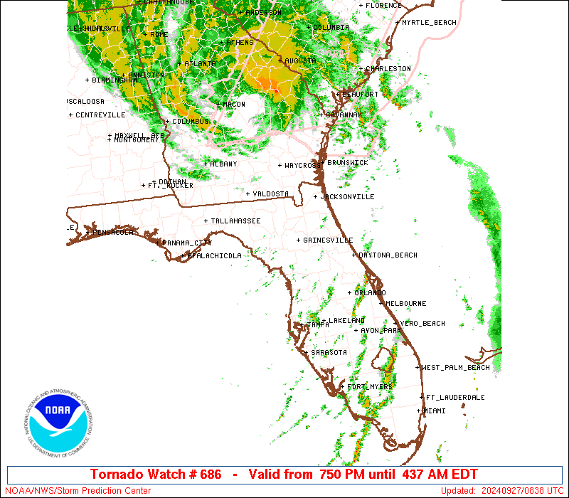
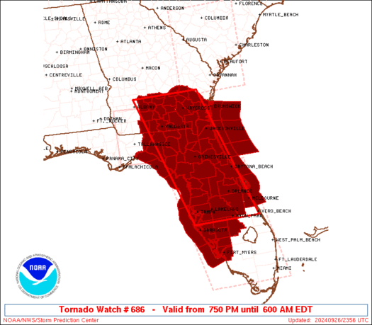
Tornado Watch Number 686
NWS Storm Prediction Center Norman OK
750 PM EDT Thu Sep 26 2024
The NWS Storm Prediction Center has issued a
* Tornado Watch for portions of
Florida
Southern Georgia
Coastal Waters
* Effective this Thursday night and Friday morning from 750 PM
until 600 AM EDT.
* Primary threats include...
Several tornadoes likely
SUMMARY...Low-topped supercells in the outer rain bands of Hurricane
Helene will continue to pose a threat for several tornadoes this
evening and continuing into the overnight hours across much of
Florida and southern Georgia.
The tornado watch area is approximately along and 70 statute miles
east and west of a line from 50 miles northwest of Waycross GA to 15
miles west southwest of Avon Park FL. For a complete depiction of
the watch see the associated watch outline update (WOUS64 KWNS
WOU6).
PRECAUTIONARY/PREPAREDNESS ACTIONS...
REMEMBER...A Tornado Watch means conditions are favorable for
tornadoes and severe thunderstorms in and close to the watch
area. Persons in these areas should be on the lookout for
threatening weather conditions and listen for later statements
and possible warnings.
&&
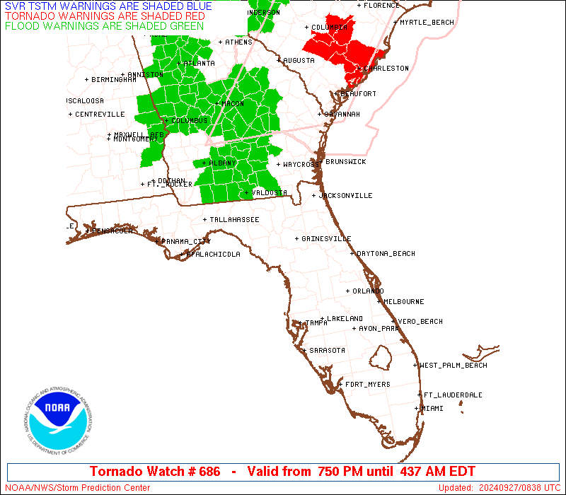
OTHER WATCH INFORMATION...CONTINUE...WW 683...WW 684...WW 685...
AVIATION...Tornadoes and a few severe thunderstorms with hail
surface and aloft to 0 inches. Extreme turbulence and surface wind
gusts to 60 knots. A few cumulonimbi with maximum tops to 500. Mean
storm motion vector 19050.
...Gleason
 Note:
The Aviation Watch (SAW) product is an approximation to the watch area.
The actual watch is depicted by the shaded areas.
Note:
The Aviation Watch (SAW) product is an approximation to the watch area.
The actual watch is depicted by the shaded areas.
   SAW6
   WW 686 TORNADO FL GA CW 262350Z - 271000Z
   AXIS..70 STATUTE MILES EAST AND WEST OF LINE..
   50NW AYS/WAYCROSS GA/ - 15WSW AGR/AVON PARK FL/
   ..AVIATION COORDS.. 60NM E/W /28WNW AMG - 54E SRQ/
   WIND GUSTS..60 KNOTS.
   MAX TOPS TO 500.MEAN STORM MOTION VECTOR 19050.

   LAT...LON 31758181 27568041 27568270 31758419

   THIS IS AN APPROXIMATION TO THE WATCH AREA.  FOR A
   COMPLETE DEPICTION OF THE WATCH SEE WOUS64 KWNS
   FOR WOU6.
Watch 686 Status Report Messages:
STATUS REPORT #4 ON WW 686

VALID 270830Z - 270940Z

SEVERE WEATHER THREAT CONTINUES RIGHT OF A LINE FROM 40 SW VDI TO
45 S AYS TO 55 NE SGJ.

..BROYLES..09/27/24

ATTN...WFO...JAX...MLB...TBW...TAE...

&&

STATUS REPORT FOR WT 686

SEVERE WEATHER THREAT CONTINUES FOR THE FOLLOWING AREAS

FLC089-270940-

FL
.    FLORIDA COUNTIES INCLUDED ARE

NASSAU
$$


GAC001-005-025-039-049-127-161-229-299-305-270940-

GA
.    GEORGIA COUNTIES INCLUDED ARE

APPLING 	     BACON		 BRANTLEY
CAMDEN		     CHARLTON		 GLYNN
JEFF DAVIS	     PIERCE		 WARE
WAYNE
$$


AMZ450-470-270940-

CW

.    ADJACENT COASTAL WATERS INCLUDED ARE

COASTAL WATERS FROM ALTAMAHA SOUND TO FERNANDINA BEACH FL OUT 20
NM

WATERS FROM ALTAMAHA SOUND GA TO FERNANDINA BEACH FL FROM 20 TO
60 NM

$$
THE WATCH STATUS MESSAGE IS FOR GUIDANCE PURPOSES ONLY.  PLEASE
REFER TO WATCH COUNTY NOTIFICATION STATEMENTS FOR OFFICIAL
INFORMATION ON COUNTIES...INDEPENDENT CITIES AND MARINE ZONES
CLEARED FROM SEVERE THUNDERSTORM AND TORNADO WATCHES.
$$

STATUS REPORT #3 ON WW 686

VALID 270625Z - 270740Z

SEVERE WEATHER THREAT CONTINUES RIGHT OF A LINE FROM 65 E DAB TO
30 WNW DAB TO 30 N GNV TO 40 WSW VDI.

..BROYLES..09/27/24

ATTN...WFO...JAX...MLB...TBW...TAE...

&&

STATUS REPORT FOR WT 686

SEVERE WEATHER THREAT CONTINUES FOR THE FOLLOWING AREAS

FLC003-007-019-031-035-089-107-109-125-270740-

FL
.    FLORIDA COUNTIES INCLUDED ARE

BAKER		     BRADFORD		 CLAY
DUVAL		     FLAGLER		 NASSAU
PUTNAM		     ST. JOHNS		 UNION
$$


GAC001-005-025-039-049-127-161-229-299-305-270740-

GA
.    GEORGIA COUNTIES INCLUDED ARE

APPLING 	     BACON		 BRANTLEY
CAMDEN		     CHARLTON		 GLYNN
JEFF DAVIS	     PIERCE		 WARE
WAYNE
$$


AMZ450-452-454-470-472-474-550-270740-

CW

.    ADJACENT COASTAL WATERS INCLUDED ARE

COASTAL WATERS FROM ALTAMAHA SOUND TO FERNANDINA BEACH FL OUT 20
NM

COASTAL WATERS FROM FERNANDINA BEACH TO ST. AUGUSTINE FL OUT 20
NM

COASTAL WATERS FROM ST. AUGUSTINE TO FLAGLER BEACH FL OUT 20 NM

WATERS FROM ALTAMAHA SOUND GA TO FERNANDINA BEACH FL FROM 20 TO
60 NM

WATERS FROM FERNANDINA BEACH TO ST. AUGUSTINE FL FROM 20 TO 60 NM

WATERS FROM ST. AUGUSTINE TO FLAGLER BEACH FL FROM 20 TO 60 NM

FLAGLER BEACH TO VOLUSIA-BREVARD COUNTY LINE 0-20 NM

$$
THE WATCH STATUS MESSAGE IS FOR GUIDANCE PURPOSES ONLY.  PLEASE
REFER TO WATCH COUNTY NOTIFICATION STATEMENTS FOR OFFICIAL
INFORMATION ON COUNTIES...INDEPENDENT CITIES AND MARINE ZONES
CLEARED FROM SEVERE THUNDERSTORM AND TORNADO WATCHES.
$$

STATUS REPORT #2 ON WW 686

VALID 270545Z - 270640Z

THE SEVERE WEATHER THREAT CONTINUES ACROSS THE ENTIRE WATCH AREA.

..BROYLES..09/27/24

ATTN...WFO...JAX...MLB...TBW...TAE...

&&

STATUS REPORT FOR WT 686

SEVERE WEATHER THREAT CONTINUES FOR THE FOLLOWING AREAS

FLC001-003-007-009-015-017-019-023-027-029-031-035-041-047-049-
053-055-057-065-067-069-071-075-079-081-083-089-095-097-101-103-
105-107-109-115-117-119-121-123-125-127-270640-

FL
.    FLORIDA COUNTIES INCLUDED ARE

ALACHUA 	     BAKER		 BRADFORD
BREVARD 	     CHARLOTTE		 CITRUS
CLAY		     COLUMBIA		 DESOTO
DIXIE		     DUVAL		 FLAGLER
GILCHRIST	     HAMILTON		 HARDEE
HERNANDO	     HIGHLANDS		 HILLSBOROUGH
JEFFERSON	     LAFAYETTE		 LAKE
LEE		     LEVY		 MADISON
MANATEE 	     MARION		 NASSAU
ORANGE		     OSCEOLA		 PASCO
PINELLAS	     POLK		 PUTNAM
ST. JOHNS	     SARASOTA		 SEMINOLE
SUMTER		     SUWANNEE		 TAYLOR
UNION		     VOLUSIA
$$


GAC001-003-005-017-019-025-027-039-049-065-069-071-075-101-127-
155-161-173-185-229-275-277-287-299-305-321-270640-

GA
.    GEORGIA COUNTIES INCLUDED ARE

APPLING 	     ATKINSON		 BACON
BEN HILL	     BERRIEN		 BRANTLEY
BROOKS		     CAMDEN		 CHARLTON
CLINCH		     COFFEE		 COLQUITT
COOK		     ECHOLS		 GLYNN
IRWIN		     JEFF DAVIS 	 LANIER
LOWNDES 	     PIERCE		 THOMAS
TIFT		     TURNER		 WARE
WAYNE		     WORTH
$$


AMZ450-452-454-470-472-474-550-552-GMZ730-765-830-836-850-853-856-
270640-

CW

.    ADJACENT COASTAL WATERS INCLUDED ARE

COASTAL WATERS FROM ALTAMAHA SOUND TO FERNANDINA BEACH FL OUT 20
NM

COASTAL WATERS FROM FERNANDINA BEACH TO ST. AUGUSTINE FL OUT 20
NM

COASTAL WATERS FROM ST. AUGUSTINE TO FLAGLER BEACH FL OUT 20 NM

WATERS FROM ALTAMAHA SOUND GA TO FERNANDINA BEACH FL FROM 20 TO
60 NM

WATERS FROM FERNANDINA BEACH TO ST. AUGUSTINE FL FROM 20 TO 60 NM

WATERS FROM ST. AUGUSTINE TO FLAGLER BEACH FL FROM 20 TO 60 NM

FLAGLER BEACH TO VOLUSIA-BREVARD COUNTY LINE 0-20 NM

VOLUSIA-BREVARD COUNTY LINE TO SEBASTIAN INLET 0-20 NM

APALACHEE BAY OR COASTAL WATERS FROM KEATON BEACH TO OCHLOCKONEE
RIVER FL OUT TO 20 NM

COASTAL WATERS FROM  SUWANNEE RIVER TO KEATON BEACH OUT 20 NM

TAMPA BAY WATERS

CHARLOTTE HARBOR AND PINE ISLAND SOUND

COASTAL WATERS FROM TARPON SPRINGS TO SUWANNEE RIVER FL OUT 20 NM

COASTAL WATERS FROM ENGLEWOOD TO TARPON SPRINGS FL OUT 20 NM

COASTAL WATERS FROM BONITA BEACH TO ENGLEWOOD FL OUT 20 NM

$$
THE WATCH STATUS MESSAGE IS FOR GUIDANCE PURPOSES ONLY.  PLEASE
REFER TO WATCH COUNTY NOTIFICATION STATEMENTS FOR OFFICIAL
INFORMATION ON COUNTIES...INDEPENDENT CITIES AND MARINE ZONES
CLEARED FROM SEVERE THUNDERSTORM AND TORNADO WATCHES.
$$

STATUS REPORT #1 ON WW 686

VALID 270320Z - 270440Z

THE SEVERE WEATHER THREAT CONTINUES ACROSS THE ENTIRE WATCH AREA.

..JEWELL..09/27/24

ATTN...WFO...JAX...MLB...TBW...TAE...

&&

STATUS REPORT FOR WT 686

SEVERE WEATHER THREAT CONTINUES FOR THE FOLLOWING AREAS

FLC001-003-007-009-015-017-019-023-027-029-031-035-041-047-049-
053-055-057-065-067-069-071-075-079-081-083-089-095-097-101-103-
105-107-109-115-117-119-121-123-125-127-270440-

FL
.    FLORIDA COUNTIES INCLUDED ARE

ALACHUA 	     BAKER		 BRADFORD
BREVARD 	     CHARLOTTE		 CITRUS
CLAY		     COLUMBIA		 DESOTO
DIXIE		     DUVAL		 FLAGLER
GILCHRIST	     HAMILTON		 HARDEE
HERNANDO	     HIGHLANDS		 HILLSBOROUGH
JEFFERSON	     LAFAYETTE		 LAKE
LEE		     LEVY		 MADISON
MANATEE 	     MARION		 NASSAU
ORANGE		     OSCEOLA		 PASCO
PINELLAS	     POLK		 PUTNAM
ST. JOHNS	     SARASOTA		 SEMINOLE
SUMTER		     SUWANNEE		 TAYLOR
UNION		     VOLUSIA
$$


GAC001-003-005-017-019-025-027-039-049-065-069-071-075-101-127-
155-161-173-185-229-275-277-287-299-305-321-270440-

GA
.    GEORGIA COUNTIES INCLUDED ARE

APPLING 	     ATKINSON		 BACON
BEN HILL	     BERRIEN		 BRANTLEY
BROOKS		     CAMDEN		 CHARLTON
CLINCH		     COFFEE		 COLQUITT
COOK		     ECHOLS		 GLYNN
IRWIN		     JEFF DAVIS 	 LANIER
LOWNDES 	     PIERCE		 THOMAS
TIFT		     TURNER		 WARE
WAYNE		     WORTH
$$


AMZ450-452-454-470-472-474-550-552-GMZ730-765-830-836-850-853-856-
270440-

CW

.    ADJACENT COASTAL WATERS INCLUDED ARE

COASTAL WATERS FROM ALTAMAHA SOUND TO FERNANDINA BEACH FL OUT 20
NM

COASTAL WATERS FROM FERNANDINA BEACH TO ST. AUGUSTINE FL OUT 20
NM

COASTAL WATERS FROM ST. AUGUSTINE TO FLAGLER BEACH FL OUT 20 NM

WATERS FROM ALTAMAHA SOUND GA TO FERNANDINA BEACH FL FROM 20 TO
60 NM

WATERS FROM FERNANDINA BEACH TO ST. AUGUSTINE FL FROM 20 TO 60 NM

WATERS FROM ST. AUGUSTINE TO FLAGLER BEACH FL FROM 20 TO 60 NM

FLAGLER BEACH TO VOLUSIA-BREVARD COUNTY LINE 0-20 NM

VOLUSIA-BREVARD COUNTY LINE TO SEBASTIAN INLET 0-20 NM

APALACHEE BAY OR COASTAL WATERS FROM KEATON BEACH TO OCHLOCKONEE
RIVER FL OUT TO 20 NM

COASTAL WATERS FROM  SUWANNEE RIVER TO KEATON BEACH OUT 20 NM

TAMPA BAY WATERS

CHARLOTTE HARBOR AND PINE ISLAND SOUND

COASTAL WATERS FROM TARPON SPRINGS TO SUWANNEE RIVER FL OUT 20 NM

COASTAL WATERS FROM ENGLEWOOD TO TARPON SPRINGS FL OUT 20 NM

COASTAL WATERS FROM BONITA BEACH TO ENGLEWOOD FL OUT 20 NM

$$
THE WATCH STATUS MESSAGE IS FOR GUIDANCE PURPOSES ONLY.  PLEASE
REFER TO WATCH COUNTY NOTIFICATION STATEMENTS FOR OFFICIAL
INFORMATION ON COUNTIES...INDEPENDENT CITIES AND MARINE ZONES
CLEARED FROM SEVERE THUNDERSTORM AND TORNADO WATCHES.
$$
Note:
Click for Complete Product Text.
Tornadoes
Probability of 2 or more tornadoes
|
High (80%)
|
Probability of 1 or more strong (EF2-EF5) tornadoes
|
Low (10%)
|
Wind
Probability of 10 or more severe wind events
|
Low (10%)
|
Probability of 1 or more wind events > 65 knots
|
Low (10%)
|
Hail
Probability of 10 or more severe hail events
|
Low (<5%)
|
Probability of 1 or more hailstones > 2 inches
|
Low (<5%)
|
Combined Severe Hail/Wind
Probability of 6 or more combined severe hail/wind events
|
Low (20%)
|
For each watch, probabilities for particular events inside the watch
(listed above in each table) are determined by the issuing forecaster.
The "Low" category contains probability values ranging from less than 2%
to 20% (EF2-EF5 tornadoes), less than 5% to 20% (all other probabilities),
"Moderate" from 30% to 60%, and "High" from 70% to greater than 95%.
High values are bolded and lighter in color to provide awareness of
an increased threat for a particular event.


 @NWSSPC