 Note:
The expiration time in the watch graphic is amended if the watch is
replaced, cancelled or extended.
Note:
Note:
The expiration time in the watch graphic is amended if the watch is
replaced, cancelled or extended.
Note: Click for
Watch Status Reports.
SEL4
URGENT - IMMEDIATE BROADCAST REQUESTED
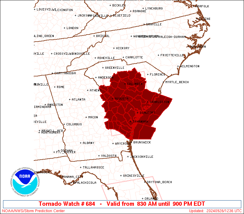
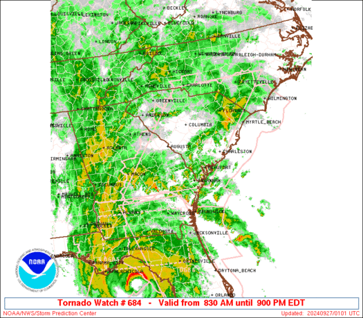
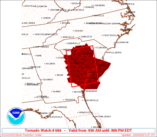
Tornado Watch Number 684
NWS Storm Prediction Center Norman OK
830 AM EDT Thu Sep 26 2024
The NWS Storm Prediction Center has issued a
* Tornado Watch for portions of
Eastern Georgia
Central and Southern South Carolina
Coastal Waters
* Effective this Thursday morning and evening from 830 AM until
900 PM EDT.
* Primary threats include...
Several tornadoes likely
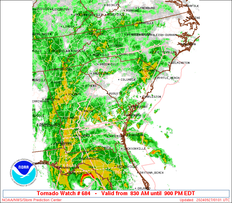
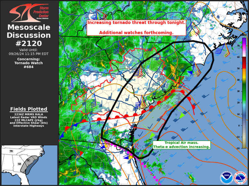
SUMMARY...A long-duration and gradually increasing tornado threat
will exist in association with the increasingly strong low-level
winds on the northeast periphery of Hurricane Helene.
The tornado watch area is approximately along and 70 statute miles
east and west of a line from 35 miles south of Savannah GA to 30
miles north of Columbia SC. For a complete depiction of the watch
see the associated watch outline update (WOUS64 KWNS WOU4).
PRECAUTIONARY/PREPAREDNESS ACTIONS...
REMEMBER...A Tornado Watch means conditions are favorable for
tornadoes and severe thunderstorms in and close to the watch
area. Persons in these areas should be on the lookout for
threatening weather conditions and listen for later statements
and possible warnings.
&&
OTHER WATCH INFORMATION...CONTINUE...WW 683...
AVIATION...Tornadoes and a few severe thunderstorms with hail
surface and aloft to 0 inches. Extreme turbulence and surface wind
gusts to 60 knots. A few cumulonimbi with maximum tops to 500. Mean
storm motion vector 16025.
...Guyer
 Note:
The Aviation Watch (SAW) product is an approximation to the watch area.
The actual watch is depicted by the shaded areas.
Note:
The Aviation Watch (SAW) product is an approximation to the watch area.
The actual watch is depicted by the shaded areas.
   SAW4
   WW 684 TORNADO GA SC CW 261230Z - 270100Z
   AXIS..70 STATUTE MILES EAST AND WEST OF LINE..
   35S SAV/SAVANNAH GA/ - 30N CAE/COLUMBIA SC/
   ..AVIATION COORDS.. 60NM E/W /33S SAV - 30N CAE/
   WIND GUSTS..60 KNOTS.
   MAX TOPS TO 500.MEAN STORM MOTION VECTOR 16025.

   LAT...LON 31628239 34368235 34367989 31628001

   THIS IS AN APPROXIMATION TO THE WATCH AREA.  FOR A
   COMPLETE DEPICTION OF THE WATCH SEE WOUS64 KWNS
   FOR WOU4.
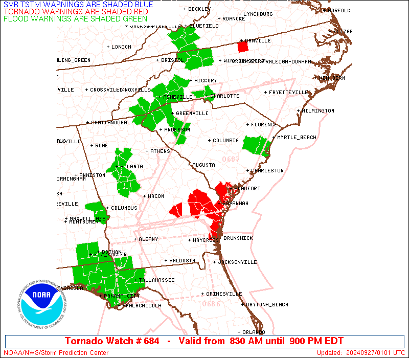
Watch 684 Status Report Messages:
STATUS REPORT #1 ON WW 684

VALID 261850Z - 261940Z

THE SEVERE WEATHER THREAT CONTINUES ACROSS THE ENTIRE WATCH AREA.

..GOSS..09/26/24

ATTN...WFO...CHS...CAE...FFC...

&&

STATUS REPORT FOR WT 684

SEVERE WEATHER THREAT CONTINUES FOR THE FOLLOWING AREAS

GAC029-031-033-043-051-073-091-103-107-109-163-165-167-175-179-
181-183-189-191-209-245-251-267-271-279-283-303-309-319-
261940-

GA
.    GEORGIA COUNTIES INCLUDED ARE

BRYAN		     BULLOCH		 BURKE
CANDLER 	     CHATHAM		 COLUMBIA
DODGE		     EFFINGHAM		 EMANUEL
EVANS		     JEFFERSON		 JENKINS
JOHNSON 	     LAURENS		 LIBERTY
LINCOLN 	     LONG		 MCDUFFIE
MCINTOSH	     MONTGOMERY 	 RICHMOND
SCREVEN 	     TATTNALL		 TELFAIR
TOOMBS		     TREUTLEN		 WASHINGTON
WHEELER 	     WILKINSON
$$


SCC003-005-009-011-013-015-017-019-027-029-035-037-039-049-053-
055-061-063-065-071-075-079-081-085-261940-

SC
.    SOUTH CAROLINA COUNTIES INCLUDED ARE

AIKEN		     ALLENDALE		 BAMBERG
BARNWELL	     BEAUFORT		 BERKELEY
CALHOUN 	     CHARLESTON 	 CLARENDON
COLLETON	     DORCHESTER 	 EDGEFIELD
FAIRFIELD	     HAMPTON		 JASPER
KERSHAW 	     LEE		 LEXINGTON
MCCORMICK	     NEWBERRY		 ORANGEBURG
RICHLAND	     SALUDA		 SUMTER
$$


AMZ330-350-352-354-370-372-374-261940-

CW

.    ADJACENT COASTAL WATERS INCLUDED ARE

CHARLESTON HARBOR

COASTAL WATERS FROM SOUTH SANTEE RIVER TO EDISTO BEACH SC OUT 20
NM

COASTAL WATERS FROM EDISTO BEACH SC TO SAVANNAH GA OUT 20 NM

COASTAL WATERS FROM SAVANNAH GA TO ALTAMAHA SOUND GA OUT 20 NM
...INCLUDING GRAYS REEF NATIONAL MARINE SANCTUARY

WATERS FROM SOUTH SANTEE RIVER SC TO EDISTO BEACH SC EXTENDING
FROM 20 NM TO 40 NM

WATERS FROM EDISTO BEACH SC TO SAVANNAH GA EXTENDING FROM 20 NM
TO 40 NM

WATERS FROM SAVANNAH GA TO ALTAMAHA SOUND GA EXTENDING FROM 20 NM
TO 60 NM

$$
THE WATCH STATUS MESSAGE IS FOR GUIDANCE PURPOSES ONLY.  PLEASE
REFER TO WATCH COUNTY NOTIFICATION STATEMENTS FOR OFFICIAL
INFORMATION ON COUNTIES...INDEPENDENT CITIES AND MARINE ZONES
CLEARED FROM SEVERE THUNDERSTORM AND TORNADO WATCHES.
$$
Note:
Click for Complete Product Text.
Tornadoes
Probability of 2 or more tornadoes
|
High (90%)
|
Probability of 1 or more strong (EF2-EF5) tornadoes
|
Low (20%)
|
Wind
Probability of 10 or more severe wind events
|
Low (10%)
|
Probability of 1 or more wind events > 65 knots
|
Low (10%)
|
Hail
Probability of 10 or more severe hail events
|
Low (<5%)
|
Probability of 1 or more hailstones > 2 inches
|
Low (<5%)
|
Combined Severe Hail/Wind
Probability of 6 or more combined severe hail/wind events
|
Low (20%)
|
For each watch, probabilities for particular events inside the watch
(listed above in each table) are determined by the issuing forecaster.
The "Low" category contains probability values ranging from less than 2%
to 20% (EF2-EF5 tornadoes), less than 5% to 20% (all other probabilities),
"Moderate" from 30% to 60%, and "High" from 70% to greater than 95%.
High values are bolded and lighter in color to provide awareness of
an increased threat for a particular event.


 @NWSSPC