Note:
The expiration time in the watch graphic is amended if the watch is
replaced, cancelled or extended.
Note:
Note:
The expiration time in the watch graphic is amended if the watch is
replaced, cancelled or extended.
Note: Click for
Watch Status Reports.
SEL5
URGENT - IMMEDIATE BROADCAST REQUESTED
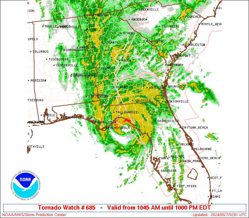
Tornado Watch Number 685
NWS Storm Prediction Center Norman OK
1045 AM EDT Thu Sep 26 2024
The NWS Storm Prediction Center has issued a
* Tornado Watch for portions of
Northern Florida
Southern Georgia
Coastal Waters
* Effective this Thursday morning and evening from 1045 AM until
1000 PM EDT.
* Primary threats include...
Several tornadoes likely
SUMMARY...Rainbands associated with Hurricane Helene will continue
to move through this area throughout the day. Wind fields will
strengthen as the hurricane continues northward, with low-level
winds becoming increasingly favorable for tornadoes. These
conditions will result in a long-duration risk for tornadoes across
northern Florida and southern Georgia.
The tornado watch area is approximately along and 60 statute miles
north and south of a line from 40 miles west northwest of
Tallahassee FL to 60 miles north northeast of Gainesville FL. For a
complete depiction of the watch see the associated watch outline
update (WOUS64 KWNS WOU5).
PRECAUTIONARY/PREPAREDNESS ACTIONS...
REMEMBER...A Tornado Watch means conditions are favorable for
tornadoes and severe thunderstorms in and close to the watch
area. Persons in these areas should be on the lookout for
threatening weather conditions and listen for later statements
and possible warnings.
&&
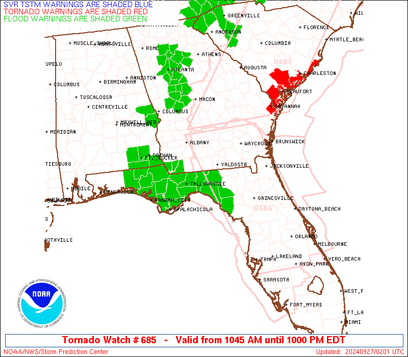
OTHER WATCH INFORMATION...CONTINUE...WW 683...WW 684...
AVIATION...Tornadoes and a few severe thunderstorms with hail
surface and aloft to 0.5 inches. Extreme turbulence and surface wind
gusts to 60 knots. A few cumulonimbi with maximum tops to 500. Mean
storm motion vector 16035.
...Mosier
   SEL5

   URGENT - IMMEDIATE BROADCAST REQUESTED
   Tornado Watch Number 685
   NWS Storm Prediction Center Norman OK
   1045 AM EDT Thu Sep 26 2024

   The NWS Storm Prediction Center has issued a

   * Tornado Watch for portions of
     Northern Florida
     Southern Georgia
     Coastal Waters

   * Effective this Thursday morning and evening from 1045 AM until
     1000 PM EDT.

   * Primary threats include...
     Several tornadoes likely

   SUMMARY...Rainbands associated with Hurricane Helene will continue
   to move through this area throughout the day. Wind fields will
   strengthen as the hurricane continues northward, with low-level
   winds becoming increasingly favorable for tornadoes. These
   conditions will result in a long-duration risk for tornadoes across
   northern Florida and southern Georgia.

   The tornado watch area is approximately along and 60 statute miles
   north and south of a line from 40 miles west northwest of
   Tallahassee FL to 60 miles north northeast of Gainesville FL. For a
   complete depiction of the watch see the associated watch outline
   update (WOUS64 KWNS WOU5).

   PRECAUTIONARY/PREPAREDNESS ACTIONS...

   REMEMBER...A Tornado Watch means conditions are favorable for
   tornadoes and severe thunderstorms in and close to the watch
   area. Persons in these areas should be on the lookout for
   threatening weather conditions and listen for later statements
   and possible warnings.

   &&

   OTHER WATCH INFORMATION...CONTINUE...WW 683...WW 684...

   AVIATION...Tornadoes and a few severe thunderstorms with hail
   surface and aloft to 0.5 inches. Extreme turbulence and surface wind
   gusts to 60 knots. A few cumulonimbi with maximum tops to 500. Mean
   storm motion vector 16035.

   ...Mosier
 Note:
The Aviation Watch (SAW) product is an approximation to the watch area.
The actual watch is depicted by the shaded areas.
Note:
The Aviation Watch (SAW) product is an approximation to the watch area.
The actual watch is depicted by the shaded areas.
SAW5
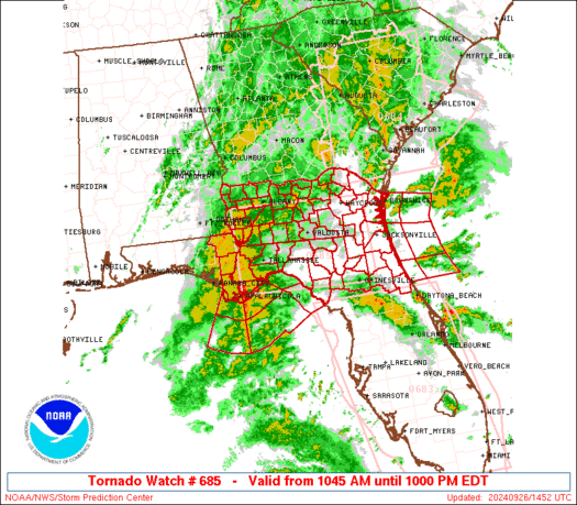
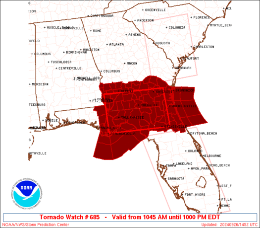
WW 685 TORNADO FL GA CW 261445Z - 270200Z
AXIS..60 STATUTE MILES NORTH AND SOUTH OF LINE..
40WNW TLH/TALLAHASSEE FL/ - 60NNE GNV/GAINESVILLE FL/
..AVIATION COORDS.. 50NM N/S /31W TLH - 21WNW CRG/
HAIL SURFACE AND ALOFT..0.5 INCH. WIND GUSTS..60 KNOTS.
MAX TOPS TO 500. MEAN STORM MOTION VECTOR 16035.
LAT...LON 31498497 31358187 29618187 29758497
THIS IS AN APPROXIMATION TO THE WATCH AREA. FOR A
COMPLETE DEPICTION OF THE WATCH SEE WOUS64 KWNS
FOR WOU5.
Watch 685 Status Report Messages:
STATUS REPORT #1 ON WW 685

VALID 261850Z - 261940Z

THE SEVERE WEATHER THREAT CONTINUES ACROSS THE ENTIRE WATCH AREA.

..GOSS..09/26/24

ATTN...WFO...JAX...TAE...

&&

STATUS REPORT FOR WT 685

SEVERE WEATHER THREAT CONTINUES FOR THE FOLLOWING AREAS

FLC001-003-005-007-013-019-023-029-031-035-037-039-041-045-047-
059-063-065-067-073-077-079-089-107-109-121-123-125-129-133-
261940-

FL
.    FLORIDA COUNTIES INCLUDED ARE

ALACHUA 	     BAKER		 BAY
BRADFORD	     CALHOUN		 CLAY
COLUMBIA	     DIXIE		 DUVAL
FLAGLER 	     FRANKLIN		 GADSDEN
GILCHRIST	     GULF		 HAMILTON
HOLMES		     JACKSON		 JEFFERSON
LAFAYETTE	     LEON		 LIBERTY
MADISON 	     NASSAU		 PUTNAM
ST. JOHNS	     SUWANNEE		 TAYLOR
UNION		     WAKULLA		 WASHINGTON
$$


GAC001-003-005-007-017-019-025-027-037-039-049-061-065-069-071-
075-087-095-099-101-127-131-155-161-173-177-185-201-205-229-239-
243-253-273-275-277-287-299-305-321-261940-

GA
.    GEORGIA COUNTIES INCLUDED ARE

APPLING 	     ATKINSON		 BACON
BAKER		     BEN HILL		 BERRIEN
BRANTLEY	     BROOKS		 CALHOUN
CAMDEN		     CHARLTON		 CLAY
CLINCH		     COFFEE		 COLQUITT
COOK		     DECATUR		 DOUGHERTY
EARLY		     ECHOLS		 GLYNN
GRADY		     IRWIN		 JEFF DAVIS
LANIER		     LEE		 LOWNDES
MILLER		     MITCHELL		 PIERCE
QUITMAN 	     RANDOLPH		 SEMINOLE
TERRELL 	     THOMAS		 TIFT
TURNER		     WARE		 WAYNE
WORTH
$$


AMZ450-452-454-470-472-474-GMZ730-752-755-765-772-775-261940-

CW

.    ADJACENT COASTAL WATERS INCLUDED ARE

COASTAL WATERS FROM ALTAMAHA SOUND TO FERNANDINA BEACH FL OUT 20
NM

COASTAL WATERS FROM FERNANDINA BEACH TO ST. AUGUSTINE FL OUT 20
NM

COASTAL WATERS FROM ST. AUGUSTINE TO FLAGLER BEACH FL OUT 20 NM

WATERS FROM ALTAMAHA SOUND GA TO FERNANDINA BEACH FL FROM 20 TO
60 NM

WATERS FROM FERNANDINA BEACH TO ST. AUGUSTINE FL FROM 20 TO 60 NM

WATERS FROM ST. AUGUSTINE TO FLAGLER BEACH FL FROM 20 TO 60 NM

APALACHEE BAY OR COASTAL WATERS FROM KEATON BEACH TO OCHLOCKONEE
RIVER FL OUT TO 20 NM

COASTAL WATERS FROM MEXICO BEACH TO APALACHICOLA OUT 20 NM

COASTAL WATERS FROM  OCHLOCKONEE RIVER TO APALACHICOLA FL OUT TO
20 NM

COASTAL WATERS FROM  SUWANNEE RIVER TO KEATON BEACH OUT 20 NM

WATERS FROM MEXICO BEACH TO APALACHICOLA FL FROM 20 TO 60 NM

WATERS FROM SUWANNEE RIVER TO APALACHICOLA FL FROM 20 TO 60 NM

$$
THE WATCH STATUS MESSAGE IS FOR GUIDANCE PURPOSES ONLY.  PLEASE
REFER TO WATCH COUNTY NOTIFICATION STATEMENTS FOR OFFICIAL
INFORMATION ON COUNTIES...INDEPENDENT CITIES AND MARINE ZONES
CLEARED FROM SEVERE THUNDERSTORM AND TORNADO WATCHES.
$$
Note:
Click for Complete Product Text.
Tornadoes
Probability of 2 or more tornadoes
|
High (80%)
|
Probability of 1 or more strong (EF2-EF5) tornadoes
|
Low (20%)
|
Wind
Probability of 10 or more severe wind events
|
Low (10%)
|
Probability of 1 or more wind events > 65 knots
|
Low (10%)
|
Hail
Probability of 10 or more severe hail events
|
Low (<5%)
|
Probability of 1 or more hailstones > 2 inches
|
Low (<5%)
|
Combined Severe Hail/Wind
Probability of 6 or more combined severe hail/wind events
|
Low (20%)
|
For each watch, probabilities for particular events inside the watch
(listed above in each table) are determined by the issuing forecaster.
The "Low" category contains probability values ranging from less than 2%
to 20% (EF2-EF5 tornadoes), less than 5% to 20% (all other probabilities),
"Moderate" from 30% to 60%, and "High" from 70% to greater than 95%.
High values are bolded and lighter in color to provide awareness of
an increased threat for a particular event.


 @NWSSPC