 Note:
The expiration time in the watch graphic is amended if the watch is
replaced, cancelled or extended.
Note:
Note:
The expiration time in the watch graphic is amended if the watch is
replaced, cancelled or extended.
Note: Click for
Watch Status Reports.
SEL8
URGENT - IMMEDIATE BROADCAST REQUESTED
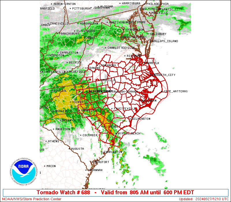
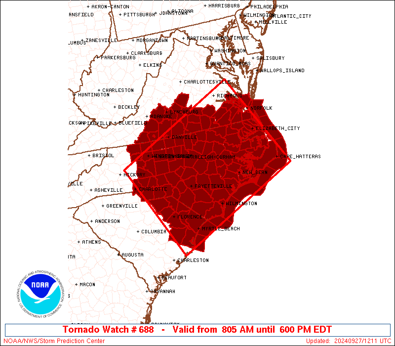
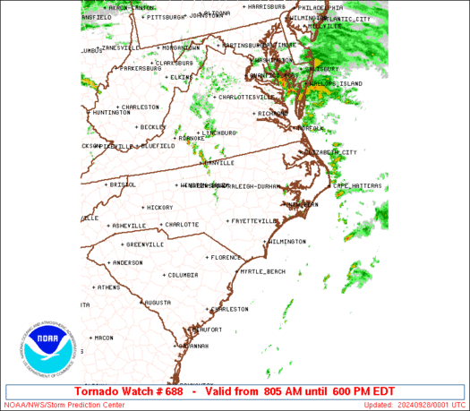
Tornado Watch Number 688
NWS Storm Prediction Center Norman OK
805 AM EDT Fri Sep 27 2024
The NWS Storm Prediction Center has issued a
* Tornado Watch for portions of
North Carolina
Eastern South Carolina
Southern Virginia
Coastal Waters
* Effective this Friday morning and evening from 805 AM until 600
PM EDT.
* Primary threats include...
A few tornadoes possible
SUMMARY...Tornado threat east of the center of Helene will shift
northward across the watch area through the day.
The tornado watch area is approximately along and 110 statute miles
either side of a line from 40 miles west northwest of Florence SC to
20 miles northeast of Elizabeth City NC. For a complete depiction of
the watch see the associated watch outline update (WOUS64 KWNS
WOU8).
PRECAUTIONARY/PREPAREDNESS ACTIONS...
REMEMBER...A Tornado Watch means conditions are favorable for
tornadoes and severe thunderstorms in and close to the watch
area. Persons in these areas should be on the lookout for
threatening weather conditions and listen for later statements
and possible warnings.
&&
OTHER WATCH INFORMATION...This tornado watch replaces tornado
watch number 687. Watch number 687 will not be in effect after
805 AM EDT.
AVIATION...Tornadoes and a few severe thunderstorms with hail
surface and aloft to 0 inches. Extreme turbulence and surface wind
gusts to 50 knots. A few cumulonimbi with maximum tops to 400. Mean
storm motion vector 6045.
...Edwards
 Note:
The Aviation Watch (SAW) product is an approximation to the watch area.
The actual watch is depicted by the shaded areas.
Note:
The Aviation Watch (SAW) product is an approximation to the watch area.
The actual watch is depicted by the shaded areas.
   SAW8
   WW 688 TORNADO NC SC VA CW 271205Z - 272200Z
   AXIS..110 STATUTE MILES EITHER SIDE OF LINE..
   40WNW FLO/FLORENCE SC/ - 20NE ECG/ELIZABETH CITY NC/
   ..AVIATION COORDS.. 95NM EITHER SIDE /37WNW FLO - 18NE ECG/
   WIND GUSTS..50 KNOTS.
   MAX TOPS TO 400.MEAN STORM MOTION VECTOR 06045.

   REPLACES WW 687..GA NC SC CW

   LAT...LON 35848121 37917679 35037510 32967956

   THIS IS AN APPROXIMATION TO THE WATCH AREA.  FOR A
   COMPLETE DEPICTION OF THE WATCH SEE WOUS64 KWNS
   FOR WOU8.
Watch 688 Status Report Messages:
STATUS REPORT #9 ON WW 688

VALID 272035Z - 272140Z

SEVERE WEATHER THREAT CONTINUES RIGHT OF A LINE FROM 30 ESE ECG
TO 45 SE RZZ TO 25 SSE RIC TO 40 E RIC TO 35 SW NHK TO 40 NW AVC
TO 10 SSE DAN TO 10 WNW DAN.

FOR ADDITIONAL INFORMATION SEE MESOSCALE DISCUSSION 2126.

..GRAMS..09/27/24

ATTN...WFO...RAH...MHX...AKQ...ILM...GSP...RNK...CAE...

&&

STATUS REPORT FOR WT 688

SEVERE WEATHER THREAT CONTINUES FOR THE FOLLOWING AREAS

NCC015-029-041-053-073-091-139-143-272140-

NC
.    NORTH CAROLINA COUNTIES INCLUDED ARE

BERTIE		     CAMDEN		 CHOWAN
CURRITUCK	     GATES		 HERTFORD
PASQUOTANK	     PERQUIMANS
$$


VAC009-011-019-029-031-037-067-083-093-095-143-175-181-183-199-
550-590-620-650-680-700-710-735-740-800-810-830-272140-

VA
.    VIRGINIA COUNTIES INCLUDED ARE

AMHERST 	     APPOMATTOX 	 BEDFORD
BUCKINGHAM	     CAMPBELL		 CHARLOTTE
FRANKLIN	     HALIFAX		 ISLE OF WIGHT
JAMES CITY	     PITTSYLVANIA	 SOUTHAMPTON
SURRY		     SUSSEX		 YORK


VIRGINIA INDEPENDENT CITIES INCLUDED ARE

CHESAPEAKE	     DANVILLE		 FRANKLIN
HAMPTON 	     LYNCHBURG		 NEWPORT NEWS
NORFOLK 	     POQUOSON		 PORTSMOUTH
SUFFOLK 	     VIRGINIA BEACH	 WILLIAMSBURG
$$


ANZ632-633-634-637-638-656-658-272140-

CW

.    ADJACENT COASTAL WATERS INCLUDED ARE

CHESAPEAKE BAY FROM NEW POINT COMFORT TO LITTLE CREEK VA

CURRITUCK SOUND

CHESAPEAKE BAY FROM LITTLE CREEK VA TO CAPE HENRY VA INCLUDING
THE CHESAPEAKE BAY BRIDGE TUNNEL

JAMES RIVER FROM JAMESTOWN TO THE JAMES RIVER BRIDGE

JAMES RIVER FROM JAMES RIVER BRIDGE TO HAMPTON ROADS
BRIDGE-TUNNEL

COASTAL WATERS FROM CAPE CHARLES LIGHT TO VIRGINIA-NORTH CAROLINA
BORDER OUT TO 20 NM

COASTAL WATERS FROM NC VA BORDER TO CURRITUCK BEACH LIGHT NC OUT
20 NM

$$
THE WATCH STATUS MESSAGE IS FOR GUIDANCE PURPOSES ONLY.  PLEASE
REFER TO WATCH COUNTY NOTIFICATION STATEMENTS FOR OFFICIAL
INFORMATION ON COUNTIES...INDEPENDENT CITIES AND MARINE ZONES
CLEARED FROM SEVERE THUNDERSTORM AND TORNADO WATCHES.
$$

STATUS REPORT #8 ON WW 688

VALID 271935Z - 272040Z

SEVERE WEATHER THREAT CONTINUES RIGHT OF A LINE FROM 55 SSE EWN
TO 30 ENE RWI TO 15 W RIC TO 20 S DAN TO 20 NNW GSO.

FOR ADDITIONAL INFORMATION SEE MESOSCALE DISCUSSION 2126.

..GRAMS..09/27/24

ATTN...WFO...RAH...MHX...AKQ...ILM...GSP...RNK...CAE...

&&

STATUS REPORT FOR WT 688

SEVERE WEATHER THREAT CONTINUES FOR THE FOLLOWING AREAS

NCC013-015-029-031-041-049-053-055-073-091-095-117-131-137-139-
143-177-187-272040-

NC
.    NORTH CAROLINA COUNTIES INCLUDED ARE

BEAUFORT	     BERTIE		 CAMDEN
CARTERET	     CHOWAN		 CRAVEN
CURRITUCK	     DARE		 GATES
HERTFORD	     HYDE		 MARTIN
NORTHAMPTON	     PAMLICO		 PASQUOTANK
PERQUIMANS	     TYRRELL		 WASHINGTON
$$


VAC009-011-019-029-031-037-067-083-089-093-095-143-147-175-181-
183-199-550-590-620-650-680-690-700-710-735-740-800-810-830-
272040-

VA
.    VIRGINIA COUNTIES INCLUDED ARE

AMHERST 	     APPOMATTOX 	 BEDFORD
BUCKINGHAM	     CAMPBELL		 CHARLOTTE
FRANKLIN	     HALIFAX		 HENRY
ISLE OF WIGHT	     JAMES CITY 	 PITTSYLVANIA
PRINCE EDWARD	     SOUTHAMPTON	 SURRY
SUSSEX		     YORK


VIRGINIA INDEPENDENT CITIES INCLUDED ARE

CHESAPEAKE	     DANVILLE		 FRANKLIN
HAMPTON 	     LYNCHBURG		 MARTINSVILLE
NEWPORT NEWS	     NORFOLK		 POQUOSON
PORTSMOUTH	     SUFFOLK		 VIRGINIA BEACH
WILLIAMSBURG
$$


AMZ131-135-136-137-150-152-154-156-230-231-ANZ632-633-634-637-638-
656-658-272040-

CW

.    ADJACENT COASTAL WATERS INCLUDED ARE

ALLIGATOR RIVER

PAMLICO SOUND

PAMLICO AND PUNGO RIVERS

NEUSE AND BAY RIVERS

S OF CURRITUCK BEACH LIGHT NC TO OREGON INLET NC OUT TO 20 NM

S OF OREGON INLET NC TO CAPE HATTERAS NC OUT TO 20 NM

S OF CAPE HATTERAS NC TO OCRACOKE INLET NC OUT TO 20 NM

S OF OCRACOKE INLET NC TO CAPE LOOKOUT NC OUT TO 20 NM

ALBEMARLE SOUND

CROATAN AND ROANOKE SOUNDS

CHESAPEAKE BAY FROM NEW POINT COMFORT TO LITTLE CREEK VA

CURRITUCK SOUND

CHESAPEAKE BAY FROM LITTLE CREEK VA TO CAPE HENRY VA INCLUDING
THE CHESAPEAKE BAY BRIDGE TUNNEL

JAMES RIVER FROM JAMESTOWN TO THE JAMES RIVER BRIDGE

JAMES RIVER FROM JAMES RIVER BRIDGE TO HAMPTON ROADS
BRIDGE-TUNNEL

COASTAL WATERS FROM CAPE CHARLES LIGHT TO VIRGINIA-NORTH CAROLINA
BORDER OUT TO 20 NM

COASTAL WATERS FROM NC VA BORDER TO CURRITUCK BEACH LIGHT NC OUT
20 NM

$$
THE WATCH STATUS MESSAGE IS FOR GUIDANCE PURPOSES ONLY.  PLEASE
REFER TO WATCH COUNTY NOTIFICATION STATEMENTS FOR OFFICIAL
INFORMATION ON COUNTIES...INDEPENDENT CITIES AND MARINE ZONES
CLEARED FROM SEVERE THUNDERSTORM AND TORNADO WATCHES.
$$

STATUS REPORT #7 ON WW 688

VALID 271835Z - 271940Z

SEVERE WEATHER THREAT CONTINUES RIGHT OF A LINE FROM 35 ESE ILM
TO 20 NNE AVC TO 20 NNW GSO.

..GRAMS..09/27/24

ATTN...WFO...RAH...MHX...AKQ...ILM...GSP...RNK...CAE...

&&

STATUS REPORT FOR WT 688

SEVERE WEATHER THREAT CONTINUES FOR THE FOLLOWING AREAS

NCC013-015-029-031-041-049-053-055-065-073-079-083-091-095-103-
107-117-131-133-137-139-143-147-177-187-271940-

NC
.    NORTH CAROLINA COUNTIES INCLUDED ARE

BEAUFORT	     BERTIE		 CAMDEN
CARTERET	     CHOWAN		 CRAVEN
CURRITUCK	     DARE		 EDGECOMBE
GATES		     GREENE		 HALIFAX
HERTFORD	     HYDE		 JONES
LENOIR		     MARTIN		 NORTHAMPTON
ONSLOW		     PAMLICO		 PASQUOTANK
PERQUIMANS	     PITT		 TYRRELL
WASHINGTON
$$


VAC009-011-019-029-031-037-053-067-081-083-089-093-095-111-135-
143-147-175-181-183-199-550-590-595-620-650-680-690-700-710-735-
740-800-810-830-271940-

VA
.    VIRGINIA COUNTIES INCLUDED ARE

AMHERST 	     APPOMATTOX 	 BEDFORD
BUCKINGHAM	     CAMPBELL		 CHARLOTTE
DINWIDDIE	     FRANKLIN		 GREENSVILLE
HALIFAX 	     HENRY		 ISLE OF WIGHT
JAMES CITY	     LUNENBURG		 NOTTOWAY
PITTSYLVANIA	     PRINCE EDWARD	 SOUTHAMPTON
SURRY		     SUSSEX		 YORK


VIRGINIA INDEPENDENT CITIES INCLUDED ARE

CHESAPEAKE	     DANVILLE		 EMPORIA
FRANKLIN	     HAMPTON		 LYNCHBURG
MARTINSVILLE	     NEWPORT NEWS	 NORFOLK
POQUOSON	     PORTSMOUTH 	 SUFFOLK
VIRGINIA BEACH	     WILLIAMSBURG
$$


AMZ131-135-136-137-150-152-154-156-158-230-231-ANZ632-633-634-637-
638-656-658-271940-

CW

.    ADJACENT COASTAL WATERS INCLUDED ARE

ALLIGATOR RIVER

PAMLICO SOUND

PAMLICO AND PUNGO RIVERS

NEUSE AND BAY RIVERS

S OF CURRITUCK BEACH LIGHT NC TO OREGON INLET NC OUT TO 20 NM

S OF OREGON INLET NC TO CAPE HATTERAS NC OUT TO 20 NM

S OF CAPE HATTERAS NC TO OCRACOKE INLET NC OUT TO 20 NM

S OF OCRACOKE INLET NC TO CAPE LOOKOUT NC OUT TO 20 NM

S OF CAPE LOOKOUT NC TO SURF CITY NC OUT TO 20 NM

ALBEMARLE SOUND

CROATAN AND ROANOKE SOUNDS

CHESAPEAKE BAY FROM NEW POINT COMFORT TO LITTLE CREEK VA

CURRITUCK SOUND

CHESAPEAKE BAY FROM LITTLE CREEK VA TO CAPE HENRY VA INCLUDING
THE CHESAPEAKE BAY BRIDGE TUNNEL

JAMES RIVER FROM JAMESTOWN TO THE JAMES RIVER BRIDGE

JAMES RIVER FROM JAMES RIVER BRIDGE TO HAMPTON ROADS
BRIDGE-TUNNEL

COASTAL WATERS FROM CAPE CHARLES LIGHT TO VIRGINIA-NORTH CAROLINA
BORDER OUT TO 20 NM

COASTAL WATERS FROM NC VA BORDER TO CURRITUCK BEACH LIGHT NC OUT
20 NM

$$
THE WATCH STATUS MESSAGE IS FOR GUIDANCE PURPOSES ONLY.  PLEASE
REFER TO WATCH COUNTY NOTIFICATION STATEMENTS FOR OFFICIAL
INFORMATION ON COUNTIES...INDEPENDENT CITIES AND MARINE ZONES
CLEARED FROM SEVERE THUNDERSTORM AND TORNADO WATCHES.
$$

STATUS REPORT #6 ON WW 688

VALID 271730Z - 271840Z

SEVERE WEATHER THREAT CONTINUES RIGHT OF A LINE FROM 45 E CRE TO
20 S AVC TO 20 W DAN.

FOR ADDITIONAL INFORMATION SEE MESOSCALE DISCUSSION 2125.

..GRAMS..09/27/24

ATTN...WFO...RAH...MHX...AKQ...ILM...GSP...RNK...CAE...

&&

STATUS REPORT FOR WT 688

SEVERE WEATHER THREAT CONTINUES FOR THE FOLLOWING AREAS

NCC013-015-029-031-041-049-053-055-061-065-073-079-083-091-095-
103-107-117-127-129-131-133-137-139-141-143-147-177-185-187-191-
195-271840-

NC
.    NORTH CAROLINA COUNTIES INCLUDED ARE

BEAUFORT	     BERTIE		 CAMDEN
CARTERET	     CHOWAN		 CRAVEN
CURRITUCK	     DARE		 DUPLIN
EDGECOMBE	     GATES		 GREENE
HALIFAX 	     HERTFORD		 HYDE
JONES		     LENOIR		 MARTIN
NASH		     NEW HANOVER	 NORTHAMPTON
ONSLOW		     PAMLICO		 PASQUOTANK
PENDER		     PERQUIMANS 	 PITT
TYRRELL 	     WARREN		 WASHINGTON
WAYNE		     WILSON
$$


VAC009-011-019-025-029-031-037-053-067-081-083-089-093-095-111-
117-135-143-147-175-181-183-199-550-590-595-620-650-680-690-700-
710-735-740-800-810-830-271840-

VA
.    VIRGINIA COUNTIES INCLUDED ARE

AMHERST 	     APPOMATTOX 	 BEDFORD
BRUNSWICK	     BUCKINGHAM 	 CAMPBELL
CHARLOTTE	     DINWIDDIE		 FRANKLIN
GREENSVILLE	     HALIFAX		 HENRY
ISLE OF WIGHT	     JAMES CITY 	 LUNENBURG
MECKLENBURG	     NOTTOWAY		 PITTSYLVANIA
PRINCE EDWARD	     SOUTHAMPTON	 SURRY
SUSSEX		     YORK


VIRGINIA INDEPENDENT CITIES INCLUDED ARE

CHESAPEAKE	     DANVILLE		 EMPORIA
FRANKLIN	     HAMPTON		 LYNCHBURG
MARTINSVILLE	     NEWPORT NEWS	 NORFOLK
POQUOSON	     PORTSMOUTH 	 SUFFOLK
VIRGINIA BEACH	     WILLIAMSBURG
$$


AMZ131-135-136-137-150-152-154-156-158-230-231-250-ANZ632-633-634-
637-638-656-658-271840-

CW

.    ADJACENT COASTAL WATERS INCLUDED ARE

ALLIGATOR RIVER

PAMLICO SOUND

PAMLICO AND PUNGO RIVERS

NEUSE AND BAY RIVERS

S OF CURRITUCK BEACH LIGHT NC TO OREGON INLET NC OUT TO 20 NM

S OF OREGON INLET NC TO CAPE HATTERAS NC OUT TO 20 NM

S OF CAPE HATTERAS NC TO OCRACOKE INLET NC OUT TO 20 NM

S OF OCRACOKE INLET NC TO CAPE LOOKOUT NC OUT TO 20 NM

S OF CAPE LOOKOUT NC TO SURF CITY NC OUT TO 20 NM

ALBEMARLE SOUND

CROATAN AND ROANOKE SOUNDS

COASTAL WATERS FROM SURF CITY TO CAPE FEAR NC OUT 20 NM

CHESAPEAKE BAY FROM NEW POINT COMFORT TO LITTLE CREEK VA

CURRITUCK SOUND

CHESAPEAKE BAY FROM LITTLE CREEK VA TO CAPE HENRY VA INCLUDING
THE CHESAPEAKE BAY BRIDGE TUNNEL

JAMES RIVER FROM JAMESTOWN TO THE JAMES RIVER BRIDGE

JAMES RIVER FROM JAMES RIVER BRIDGE TO HAMPTON ROADS
BRIDGE-TUNNEL

COASTAL WATERS FROM CAPE CHARLES LIGHT TO VIRGINIA-NORTH CAROLINA
BORDER OUT TO 20 NM

COASTAL WATERS FROM NC VA BORDER TO CURRITUCK BEACH LIGHT NC OUT
20 NM

$$
THE WATCH STATUS MESSAGE IS FOR GUIDANCE PURPOSES ONLY.  PLEASE
REFER TO WATCH COUNTY NOTIFICATION STATEMENTS FOR OFFICIAL
INFORMATION ON COUNTIES...INDEPENDENT CITIES AND MARINE ZONES
CLEARED FROM SEVERE THUNDERSTORM AND TORNADO WATCHES.
$$

STATUS REPORT #5 ON WW 688

VALID 271640Z - 271740Z

SEVERE WEATHER THREAT CONTINUES RIGHT OF A LINE FROM 30 ESE CRE
TO 25 WNW GSB TO 30 N RDU TO 15 W DAN.

FOR ADDITIONAL INFORMATION SEE MESOSCALE DISCUSSION 2125.

..GRAMS..09/27/24

ATTN...WFO...RAH...MHX...AKQ...ILM...GSP...RNK...CAE...

&&

STATUS REPORT FOR WT 688

SEVERE WEATHER THREAT CONTINUES FOR THE FOLLOWING AREAS

NCC013-015-017-019-029-031-041-047-049-053-055-061-065-069-073-
077-079-083-091-095-101-103-107-117-127-129-131-133-137-139-141-
143-147-163-177-181-183-185-187-191-195-271740-

NC
.    NORTH CAROLINA COUNTIES INCLUDED ARE

BEAUFORT	     BERTIE		 BLADEN
BRUNSWICK	     CAMDEN		 CARTERET
CHOWAN		     COLUMBUS		 CRAVEN
CURRITUCK	     DARE		 DUPLIN
EDGECOMBE	     FRANKLIN		 GATES
GRANVILLE	     GREENE		 HALIFAX
HERTFORD	     HYDE		 JOHNSTON
JONES		     LENOIR		 MARTIN
NASH		     NEW HANOVER	 NORTHAMPTON
ONSLOW		     PAMLICO		 PASQUOTANK
PENDER		     PERQUIMANS 	 PITT
SAMPSON 	     TYRRELL		 VANCE
WAKE		     WARREN		 WASHINGTON
WAYNE		     WILSON
$$


VAC009-011-019-025-029-031-037-053-067-081-083-089-093-095-111-
117-135-143-147-175-181-183-199-550-590-595-620-650-680-690-700-
710-735-740-800-810-830-271740-

VA
.    VIRGINIA COUNTIES INCLUDED ARE

AMHERST 	     APPOMATTOX 	 BEDFORD
BRUNSWICK	     BUCKINGHAM 	 CAMPBELL
CHARLOTTE	     DINWIDDIE		 FRANKLIN
GREENSVILLE	     HALIFAX		 HENRY
ISLE OF WIGHT	     JAMES CITY 	 LUNENBURG
MECKLENBURG	     NOTTOWAY		 PITTSYLVANIA
PRINCE EDWARD	     SOUTHAMPTON	 SURRY
SUSSEX		     YORK


VIRGINIA INDEPENDENT CITIES INCLUDED ARE

CHESAPEAKE	     DANVILLE		 EMPORIA
FRANKLIN	     HAMPTON		 LYNCHBURG
MARTINSVILLE	     NEWPORT NEWS	 NORFOLK
POQUOSON	     PORTSMOUTH 	 SUFFOLK
VIRGINIA BEACH	     WILLIAMSBURG
$$


AMZ131-135-136-137-150-152-154-156-158-230-231-250-252-ANZ632-633-
634-637-638-656-658-271740-

CW

.    ADJACENT COASTAL WATERS INCLUDED ARE

ALLIGATOR RIVER

PAMLICO SOUND

PAMLICO AND PUNGO RIVERS

NEUSE AND BAY RIVERS

S OF CURRITUCK BEACH LIGHT NC TO OREGON INLET NC OUT TO 20 NM

S OF OREGON INLET NC TO CAPE HATTERAS NC OUT TO 20 NM

S OF CAPE HATTERAS NC TO OCRACOKE INLET NC OUT TO 20 NM

S OF OCRACOKE INLET NC TO CAPE LOOKOUT NC OUT TO 20 NM

S OF CAPE LOOKOUT NC TO SURF CITY NC OUT TO 20 NM

ALBEMARLE SOUND

CROATAN AND ROANOKE SOUNDS

COASTAL WATERS FROM SURF CITY TO CAPE FEAR NC OUT 20 NM

COASTAL WATERS FROM CAPE FEAR NC TO LITTLE RIVER INLET SC OUT 20
NM

CHESAPEAKE BAY FROM NEW POINT COMFORT TO LITTLE CREEK VA

CURRITUCK SOUND

CHESAPEAKE BAY FROM LITTLE CREEK VA TO CAPE HENRY VA INCLUDING
THE CHESAPEAKE BAY BRIDGE TUNNEL

JAMES RIVER FROM JAMESTOWN TO THE JAMES RIVER BRIDGE

JAMES RIVER FROM JAMES RIVER BRIDGE TO HAMPTON ROADS
BRIDGE-TUNNEL

COASTAL WATERS FROM CAPE CHARLES LIGHT TO VIRGINIA-NORTH CAROLINA
BORDER OUT TO 20 NM

COASTAL WATERS FROM NC VA BORDER TO CURRITUCK BEACH LIGHT NC OUT
20 NM

$$
THE WATCH STATUS MESSAGE IS FOR GUIDANCE PURPOSES ONLY.  PLEASE
REFER TO WATCH COUNTY NOTIFICATION STATEMENTS FOR OFFICIAL
INFORMATION ON COUNTIES...INDEPENDENT CITIES AND MARINE ZONES
CLEARED FROM SEVERE THUNDERSTORM AND TORNADO WATCHES.
$$

STATUS REPORT #4 ON WW 688

VALID 271530Z - 271640Z

SEVERE WEATHER THREAT CONTINUES RIGHT OF A LINE FROM 30 S CRE TO
10 E FAY TO 15 W RDU TO 20 W DAN.

FOR ADDITIONAL INFORMATION SEE MESOSCALE DISCUSSION 2124.

..GRAMS..09/27/24

ATTN...WFO...RAH...MHX...AKQ...ILM...GSP...RNK...CAE...

&&

STATUS REPORT FOR WT 688

SEVERE WEATHER THREAT CONTINUES FOR THE FOLLOWING AREAS

NCC013-015-017-019-029-031-033-041-047-049-053-055-061-063-065-
069-073-077-079-083-085-091-095-101-103-107-117-127-129-131-133-
135-137-139-141-143-145-147-163-177-181-183-185-187-191-195-
271640-

NC
.    NORTH CAROLINA COUNTIES INCLUDED ARE

BEAUFORT	     BERTIE		 BLADEN
BRUNSWICK	     CAMDEN		 CARTERET
CASWELL 	     CHOWAN		 COLUMBUS
CRAVEN		     CURRITUCK		 DARE
DUPLIN		     DURHAM		 EDGECOMBE
FRANKLIN	     GATES		 GRANVILLE
GREENE		     HALIFAX		 HARNETT
HERTFORD	     HYDE		 JOHNSTON
JONES		     LENOIR		 MARTIN
NASH		     NEW HANOVER	 NORTHAMPTON
ONSLOW		     ORANGE		 PAMLICO
PASQUOTANK	     PENDER		 PERQUIMANS
PERSON		     PITT		 SAMPSON
TYRRELL 	     VANCE		 WAKE
WARREN		     WASHINGTON 	 WAYNE
WILSON
$$


SCC051-271640-

SC
.    SOUTH CAROLINA COUNTIES INCLUDED ARE

HORRY
$$


VAC009-011-019-025-029-031-037-053-067-081-083-089-093-095-111-
117-135-143-147-175-181-183-199-550-590-595-620-650-680-690-700-
710-735-740-800-810-830-271640-

VA
.    VIRGINIA COUNTIES INCLUDED ARE

AMHERST 	     APPOMATTOX 	 BEDFORD
BRUNSWICK	     BUCKINGHAM 	 CAMPBELL
CHARLOTTE	     DINWIDDIE		 FRANKLIN
GREENSVILLE	     HALIFAX		 HENRY
ISLE OF WIGHT	     JAMES CITY 	 LUNENBURG
MECKLENBURG	     NOTTOWAY		 PITTSYLVANIA
PRINCE EDWARD	     SOUTHAMPTON	 SURRY
SUSSEX		     YORK


VIRGINIA INDEPENDENT CITIES INCLUDED ARE

CHESAPEAKE	     DANVILLE		 EMPORIA
FRANKLIN	     HAMPTON		 LYNCHBURG
MARTINSVILLE	     NEWPORT NEWS	 NORFOLK
POQUOSON	     PORTSMOUTH 	 SUFFOLK
VIRGINIA BEACH	     WILLIAMSBURG
$$


AMZ131-135-136-137-150-152-154-156-158-230-231-250-252-254-ANZ632-
633-634-637-638-656-658-271640-

CW

.    ADJACENT COASTAL WATERS INCLUDED ARE

ALLIGATOR RIVER

PAMLICO SOUND

PAMLICO AND PUNGO RIVERS

NEUSE AND BAY RIVERS

S OF CURRITUCK BEACH LIGHT NC TO OREGON INLET NC OUT TO 20 NM

S OF OREGON INLET NC TO CAPE HATTERAS NC OUT TO 20 NM

S OF CAPE HATTERAS NC TO OCRACOKE INLET NC OUT TO 20 NM

S OF OCRACOKE INLET NC TO CAPE LOOKOUT NC OUT TO 20 NM

S OF CAPE LOOKOUT NC TO SURF CITY NC OUT TO 20 NM

ALBEMARLE SOUND

CROATAN AND ROANOKE SOUNDS

COASTAL WATERS FROM SURF CITY TO CAPE FEAR NC OUT 20 NM

COASTAL WATERS FROM CAPE FEAR NC TO LITTLE RIVER INLET SC OUT 20
NM

COASTAL WATERS FROM LITTLE RIVER INLET TO MURRELLS INLET SC OUT
20 NM

CHESAPEAKE BAY FROM NEW POINT COMFORT TO LITTLE CREEK VA

CURRITUCK SOUND

CHESAPEAKE BAY FROM LITTLE CREEK VA TO CAPE HENRY VA INCLUDING
THE CHESAPEAKE BAY BRIDGE TUNNEL

JAMES RIVER FROM JAMESTOWN TO THE JAMES RIVER BRIDGE

JAMES RIVER FROM JAMES RIVER BRIDGE TO HAMPTON ROADS
BRIDGE-TUNNEL

COASTAL WATERS FROM CAPE CHARLES LIGHT TO VIRGINIA-NORTH CAROLINA
BORDER OUT TO 20 NM

COASTAL WATERS FROM NC VA BORDER TO CURRITUCK BEACH LIGHT NC OUT
20 NM

$$
THE WATCH STATUS MESSAGE IS FOR GUIDANCE PURPOSES ONLY.  PLEASE
REFER TO WATCH COUNTY NOTIFICATION STATEMENTS FOR OFFICIAL
INFORMATION ON COUNTIES...INDEPENDENT CITIES AND MARINE ZONES
CLEARED FROM SEVERE THUNDERSTORM AND TORNADO WATCHES.
$$

STATUS REPORT #3 ON WW 688

VALID 271430Z - 271540Z

SEVERE WEATHER THREAT CONTINUES RIGHT OF A LINE FROM 40 ENE CHS
TO 15 WNW FAY TO 20 NNW GSO.

FOR ADDITIONAL INFORMATION SEE MESOSCALE DISCUSSION 2124.

..GRAMS..09/27/24

ATTN...WFO...RAH...MHX...AKQ...ILM...GSP...RNK...CAE...

&&

STATUS REPORT FOR WT 688

SEVERE WEATHER THREAT CONTINUES FOR THE FOLLOWING AREAS

NCC001-013-015-017-019-029-031-033-037-041-047-049-051-053-055-
061-063-065-069-073-077-079-081-083-085-091-095-101-103-105-107-
117-127-129-131-133-135-137-139-141-143-145-147-155-157-163-169-
177-181-183-185-187-191-195-271540-

NC
.    NORTH CAROLINA COUNTIES INCLUDED ARE

ALAMANCE	     BEAUFORT		 BERTIE
BLADEN		     BRUNSWICK		 CAMDEN
CARTERET	     CASWELL		 CHATHAM
CHOWAN		     COLUMBUS		 CRAVEN
CUMBERLAND	     CURRITUCK		 DARE
DUPLIN		     DURHAM		 EDGECOMBE
FRANKLIN	     GATES		 GRANVILLE
GREENE		     GUILFORD		 HALIFAX
HARNETT 	     HERTFORD		 HYDE
JOHNSTON	     JONES		 LEE
LENOIR		     MARTIN		 NASH
NEW HANOVER	     NORTHAMPTON	 ONSLOW
ORANGE		     PAMLICO		 PASQUOTANK
PENDER		     PERQUIMANS 	 PERSON
PITT		     ROBESON		 ROCKINGHAM
SAMPSON 	     STOKES		 TYRRELL
VANCE		     WAKE		 WARREN
WASHINGTON	     WAYNE		 WILSON
$$


SCC043-051-271540-

SC
.    SOUTH CAROLINA COUNTIES INCLUDED ARE

GEORGETOWN	     HORRY
$$


VAC009-011-019-025-029-031-037-053-067-081-083-089-093-095-111-
117-135-141-143-147-175-181-183-199-550-590-595-620-650-680-690-
700-710-735-740-800-810-830-271540-

VA
.    VIRGINIA COUNTIES INCLUDED ARE

AMHERST 	     APPOMATTOX 	 BEDFORD
BRUNSWICK	     BUCKINGHAM 	 CAMPBELL
CHARLOTTE	     DINWIDDIE		 FRANKLIN
GREENSVILLE	     HALIFAX		 HENRY
ISLE OF WIGHT	     JAMES CITY 	 LUNENBURG
MECKLENBURG	     NOTTOWAY		 PATRICK
PITTSYLVANIA	     PRINCE EDWARD	 SOUTHAMPTON
SURRY		     SUSSEX		 YORK


VIRGINIA INDEPENDENT CITIES INCLUDED ARE

CHESAPEAKE	     DANVILLE		 EMPORIA
FRANKLIN	     HAMPTON		 LYNCHBURG
MARTINSVILLE	     NEWPORT NEWS	 NORFOLK
POQUOSON	     PORTSMOUTH 	 SUFFOLK
VIRGINIA BEACH	     WILLIAMSBURG
$$


AMZ131-135-136-137-150-152-154-156-158-230-231-250-252-254-256-
ANZ632-633-634-637-638-656-658-271540-

CW

.    ADJACENT COASTAL WATERS INCLUDED ARE

ALLIGATOR RIVER

PAMLICO SOUND

PAMLICO AND PUNGO RIVERS

NEUSE AND BAY RIVERS

S OF CURRITUCK BEACH LIGHT NC TO OREGON INLET NC OUT TO 20 NM

S OF OREGON INLET NC TO CAPE HATTERAS NC OUT TO 20 NM

S OF CAPE HATTERAS NC TO OCRACOKE INLET NC OUT TO 20 NM

S OF OCRACOKE INLET NC TO CAPE LOOKOUT NC OUT TO 20 NM

S OF CAPE LOOKOUT NC TO SURF CITY NC OUT TO 20 NM

ALBEMARLE SOUND

CROATAN AND ROANOKE SOUNDS

COASTAL WATERS FROM SURF CITY TO CAPE FEAR NC OUT 20 NM

COASTAL WATERS FROM CAPE FEAR NC TO LITTLE RIVER INLET SC OUT 20
NM

COASTAL WATERS FROM LITTLE RIVER INLET TO MURRELLS INLET SC OUT
20 NM

COASTAL WATERS FROM MURRELLS INLET TO SOUTH SANTEE RIVER SC OUT
20 NM

CHESAPEAKE BAY FROM NEW POINT COMFORT TO LITTLE CREEK VA

CURRITUCK SOUND

CHESAPEAKE BAY FROM LITTLE CREEK VA TO CAPE HENRY VA INCLUDING
THE CHESAPEAKE BAY BRIDGE TUNNEL

JAMES RIVER FROM JAMESTOWN TO THE JAMES RIVER BRIDGE

JAMES RIVER FROM JAMES RIVER BRIDGE TO HAMPTON ROADS
BRIDGE-TUNNEL

COASTAL WATERS FROM CAPE CHARLES LIGHT TO VIRGINIA-NORTH CAROLINA
BORDER OUT TO 20 NM

COASTAL WATERS FROM NC VA BORDER TO CURRITUCK BEACH LIGHT NC OUT
20 NM

$$
THE WATCH STATUS MESSAGE IS FOR GUIDANCE PURPOSES ONLY.  PLEASE
REFER TO WATCH COUNTY NOTIFICATION STATEMENTS FOR OFFICIAL
INFORMATION ON COUNTIES...INDEPENDENT CITIES AND MARINE ZONES
CLEARED FROM SEVERE THUNDERSTORM AND TORNADO WATCHES.
$$

STATUS REPORT #2 ON WW 688

VALID 271325Z - 271440Z

SEVERE WEATHER THREAT CONTINUES RIGHT OF A LINE FROM 40 ENE CHS
TO 25 WSW SOP TO 5 NE CLT.

..GRAMS..09/27/24

ATTN...WFO...RAH...MHX...AKQ...ILM...GSP...RNK...CAE...

&&

STATUS REPORT FOR WT 688

SEVERE WEATHER THREAT CONTINUES FOR THE FOLLOWING AREAS

NCC001-013-015-017-019-025-029-031-033-037-041-047-049-051-053-
055-057-059-061-063-065-067-069-073-077-079-081-083-085-091-093-
095-101-103-105-107-117-119-123-125-127-129-131-133-135-137-139-
141-143-145-147-151-153-155-157-159-163-165-167-169-171-177-181-
183-185-187-191-195-197-271440-

NC
.    NORTH CAROLINA COUNTIES INCLUDED ARE

ALAMANCE	     BEAUFORT		 BERTIE
BLADEN		     BRUNSWICK		 CABARRUS
CAMDEN		     CARTERET		 CASWELL
CHATHAM 	     CHOWAN		 COLUMBUS
CRAVEN		     CUMBERLAND 	 CURRITUCK
DARE		     DAVIDSON		 DAVIE
DUPLIN		     DURHAM		 EDGECOMBE
FORSYTH 	     FRANKLIN		 GATES
GRANVILLE	     GREENE		 GUILFORD
HALIFAX 	     HARNETT		 HERTFORD
HOKE		     HYDE		 JOHNSTON
JONES		     LEE		 LENOIR
MARTIN		     MECKLENBURG	 MONTGOMERY
MOORE		     NASH		 NEW HANOVER
NORTHAMPTON	     ONSLOW		 ORANGE
PAMLICO 	     PASQUOTANK 	 PENDER
PERQUIMANS	     PERSON		 PITT
RANDOLPH	     RICHMOND		 ROBESON
ROCKINGHAM	     ROWAN		 SAMPSON
SCOTLAND	     STANLY		 STOKES
SURRY		     TYRRELL		 VANCE
WAKE		     WARREN		 WASHINGTON
WAYNE		     WILSON		 YADKIN
$$


SCC033-043-051-067-069-271440-

SC
.    SOUTH CAROLINA COUNTIES INCLUDED ARE

DILLON		     GEORGETOWN 	 HORRY
MARION		     MARLBORO
$$


VAC009-011-019-025-029-031-037-053-067-081-083-089-093-095-111-
117-135-141-143-147-175-181-183-199-550-590-595-620-650-680-690-
700-710-735-740-800-810-830-271440-

VA
.    VIRGINIA COUNTIES INCLUDED ARE

AMHERST 	     APPOMATTOX 	 BEDFORD
BRUNSWICK	     BUCKINGHAM 	 CAMPBELL
CHARLOTTE	     DINWIDDIE		 FRANKLIN
GREENSVILLE	     HALIFAX		 HENRY
ISLE OF WIGHT	     JAMES CITY 	 LUNENBURG
MECKLENBURG	     NOTTOWAY		 PATRICK
PITTSYLVANIA	     PRINCE EDWARD	 SOUTHAMPTON
SURRY		     SUSSEX		 YORK


VIRGINIA INDEPENDENT CITIES INCLUDED ARE

CHESAPEAKE	     DANVILLE		 EMPORIA
FRANKLIN	     HAMPTON		 LYNCHBURG
MARTINSVILLE	     NEWPORT NEWS	 NORFOLK
POQUOSON	     PORTSMOUTH 	 SUFFOLK
VIRGINIA BEACH	     WILLIAMSBURG
$$


AMZ131-135-136-137-150-152-154-156-158-230-231-250-252-254-256-
ANZ632-633-634-637-638-656-658-271440-

CW

.    ADJACENT COASTAL WATERS INCLUDED ARE

ALLIGATOR RIVER

PAMLICO SOUND

PAMLICO AND PUNGO RIVERS

NEUSE AND BAY RIVERS

S OF CURRITUCK BEACH LIGHT NC TO OREGON INLET NC OUT TO 20 NM

S OF OREGON INLET NC TO CAPE HATTERAS NC OUT TO 20 NM

S OF CAPE HATTERAS NC TO OCRACOKE INLET NC OUT TO 20 NM

S OF OCRACOKE INLET NC TO CAPE LOOKOUT NC OUT TO 20 NM

S OF CAPE LOOKOUT NC TO SURF CITY NC OUT TO 20 NM

ALBEMARLE SOUND

CROATAN AND ROANOKE SOUNDS

COASTAL WATERS FROM SURF CITY TO CAPE FEAR NC OUT 20 NM

COASTAL WATERS FROM CAPE FEAR NC TO LITTLE RIVER INLET SC OUT 20
NM

COASTAL WATERS FROM LITTLE RIVER INLET TO MURRELLS INLET SC OUT
20 NM

COASTAL WATERS FROM MURRELLS INLET TO SOUTH SANTEE RIVER SC OUT
20 NM

CHESAPEAKE BAY FROM NEW POINT COMFORT TO LITTLE CREEK VA

CURRITUCK SOUND

CHESAPEAKE BAY FROM LITTLE CREEK VA TO CAPE HENRY VA INCLUDING
THE CHESAPEAKE BAY BRIDGE TUNNEL

JAMES RIVER FROM JAMESTOWN TO THE JAMES RIVER BRIDGE

JAMES RIVER FROM JAMES RIVER BRIDGE TO HAMPTON ROADS
BRIDGE-TUNNEL

COASTAL WATERS FROM CAPE CHARLES LIGHT TO VIRGINIA-NORTH CAROLINA
BORDER OUT TO 20 NM

COASTAL WATERS FROM NC VA BORDER TO CURRITUCK BEACH LIGHT NC OUT
20 NM

$$
THE WATCH STATUS MESSAGE IS FOR GUIDANCE PURPOSES ONLY.  PLEASE
REFER TO WATCH COUNTY NOTIFICATION STATEMENTS FOR OFFICIAL
INFORMATION ON COUNTIES...INDEPENDENT CITIES AND MARINE ZONES
CLEARED FROM SEVERE THUNDERSTORM AND TORNADO WATCHES.
$$

STATUS REPORT #1 ON WW 688

VALID 271235Z - 271340Z

THE SEVERE WEATHER THREAT CONTINUES ACROSS THE ENTIRE WATCH AREA.

..BROYLES..09/27/24

ATTN...WFO...RAH...MHX...AKQ...ILM...GSP...RNK...CAE...

&&

STATUS REPORT FOR WT 688

SEVERE WEATHER THREAT CONTINUES FOR THE FOLLOWING AREAS

NCC001-007-013-015-017-019-025-029-031-033-037-041-047-049-051-
053-055-057-059-061-063-065-067-069-073-077-079-081-083-085-091-
093-095-101-103-105-107-117-119-123-125-127-129-131-133-135-137-
139-141-143-145-147-151-153-155-157-159-163-165-167-169-171-177-
179-181-183-185-187-191-195-197-271340-

NC
.    NORTH CAROLINA COUNTIES INCLUDED ARE

ALAMANCE	     ANSON		 BEAUFORT
BERTIE		     BLADEN		 BRUNSWICK
CABARRUS	     CAMDEN		 CARTERET
CASWELL 	     CHATHAM		 CHOWAN
COLUMBUS	     CRAVEN		 CUMBERLAND
CURRITUCK	     DARE		 DAVIDSON
DAVIE		     DUPLIN		 DURHAM
EDGECOMBE	     FORSYTH		 FRANKLIN
GATES		     GRANVILLE		 GREENE
GUILFORD	     HALIFAX		 HARNETT
HERTFORD	     HOKE		 HYDE
JOHNSTON	     JONES		 LEE
LENOIR		     MARTIN		 MECKLENBURG
MONTGOMERY	     MOORE		 NASH
NEW HANOVER	     NORTHAMPTON	 ONSLOW
ORANGE		     PAMLICO		 PASQUOTANK
PENDER		     PERQUIMANS 	 PERSON
PITT		     RANDOLPH		 RICHMOND
ROBESON 	     ROCKINGHAM 	 ROWAN
SAMPSON 	     SCOTLAND		 STANLY
STOKES		     SURRY		 TYRRELL
UNION		     VANCE		 WAKE
WARREN		     WASHINGTON 	 WAYNE
WILSON		     YADKIN
$$


SCC025-031-033-041-043-051-067-069-089-271340-

SC
.    SOUTH CAROLINA COUNTIES INCLUDED ARE

CHESTERFIELD	     DARLINGTON 	 DILLON
FLORENCE	     GEORGETOWN 	 HORRY
MARION		     MARLBORO		 WILLIAMSBURG
$$


VAC011-019-025-029-031-037-053-067-081-083-089-093-095-111-117-
135-141-143-147-175-181-183-199-550-590-595-620-650-680-690-700-
735-800-810-830-271340-

VA
.    VIRGINIA COUNTIES INCLUDED ARE

APPOMATTOX	     BEDFORD		 BRUNSWICK
BUCKINGHAM	     CAMPBELL		 CHARLOTTE
DINWIDDIE	     FRANKLIN		 GREENSVILLE
HALIFAX 	     HENRY		 ISLE OF WIGHT
JAMES CITY	     LUNENBURG		 MECKLENBURG
NOTTOWAY	     PATRICK		 PITTSYLVANIA
PRINCE EDWARD	     SOUTHAMPTON	 SURRY
SUSSEX		     YORK


VIRGINIA INDEPENDENT CITIES INCLUDED ARE

CHESAPEAKE	     DANVILLE		 EMPORIA
FRANKLIN	     HAMPTON		 LYNCHBURG
MARTINSVILLE	     NEWPORT NEWS	 POQUOSON
SUFFOLK 	     VIRGINIA BEACH	 WILLIAMSBURG
$$


AMZ131-135-136-137-150-152-154-156-158-230-250-252-254-256-ANZ632-
633-634-637-638-656-658-271340-

CW

.    ADJACENT COASTAL WATERS INCLUDED ARE

ALLIGATOR RIVER

PAMLICO SOUND

PAMLICO AND PUNGO RIVERS

NEUSE AND BAY RIVERS

S OF CURRITUCK BEACH LIGHT NC TO OREGON INLET NC OUT TO 20 NM

S OF OREGON INLET NC TO CAPE HATTERAS NC OUT TO 20 NM

S OF CAPE HATTERAS NC TO OCRACOKE INLET NC OUT TO 20 NM

S OF OCRACOKE INLET NC TO CAPE LOOKOUT NC OUT TO 20 NM

S OF CAPE LOOKOUT NC TO SURF CITY NC OUT TO 20 NM

ALBEMARLE SOUND

COASTAL WATERS FROM SURF CITY TO CAPE FEAR NC OUT 20 NM

COASTAL WATERS FROM CAPE FEAR NC TO LITTLE RIVER INLET SC OUT 20
NM

COASTAL WATERS FROM LITTLE RIVER INLET TO MURRELLS INLET SC OUT
20 NM

COASTAL WATERS FROM MURRELLS INLET TO SOUTH SANTEE RIVER SC OUT
20 NM

CHESAPEAKE BAY FROM NEW POINT COMFORT TO LITTLE CREEK VA

CURRITUCK SOUND

CHESAPEAKE BAY FROM LITTLE CREEK VA TO CAPE HENRY VA INCLUDING
THE CHESAPEAKE BAY BRIDGE TUNNEL

JAMES RIVER FROM JAMESTOWN TO THE JAMES RIVER BRIDGE

JAMES RIVER FROM JAMES RIVER BRIDGE TO HAMPTON ROADS
BRIDGE-TUNNEL

COASTAL WATERS FROM CAPE CHARLES LIGHT TO VIRGINIA-NORTH CAROLINA
BORDER OUT TO 20 NM

COASTAL WATERS FROM NC VA BORDER TO CURRITUCK BEACH LIGHT NC OUT
20 NM

$$
THE WATCH STATUS MESSAGE IS FOR GUIDANCE PURPOSES ONLY.  PLEASE
REFER TO WATCH COUNTY NOTIFICATION STATEMENTS FOR OFFICIAL
INFORMATION ON COUNTIES...INDEPENDENT CITIES AND MARINE ZONES
CLEARED FROM SEVERE THUNDERSTORM AND TORNADO WATCHES.
$$
Note:
Click for Complete Product Text.
Tornadoes
Probability of 2 or more tornadoes
|
Mod (50%)
|
Probability of 1 or more strong (EF2-EF5) tornadoes
|
Low (20%)
|
Wind
Probability of 10 or more severe wind events
|
Low (<5%)
|
Probability of 1 or more wind events > 65 knots
|
Low (<5%)
|
Hail
Probability of 10 or more severe hail events
|
Low (<5%)
|
Probability of 1 or more hailstones > 2 inches
|
Low (<5%)
|
Combined Severe Hail/Wind
Probability of 6 or more combined severe hail/wind events
|
Low (20%)
|
For each watch, probabilities for particular events inside the watch
(listed above in each table) are determined by the issuing forecaster.
The "Low" category contains probability values ranging from less than 2%
to 20% (EF2-EF5 tornadoes), less than 5% to 20% (all other probabilities),
"Moderate" from 30% to 60%, and "High" from 70% to greater than 95%.
High values are bolded and lighter in color to provide awareness of
an increased threat for a particular event.


 @NWSSPC