Note:
The expiration time in the watch graphic is amended if the watch is
replaced, cancelled or extended.
Note:
Note:
The expiration time in the watch graphic is amended if the watch is
replaced, cancelled or extended.
Note: Click for
Watch Status Reports.
SEL3
URGENT - IMMEDIATE BROADCAST REQUESTED
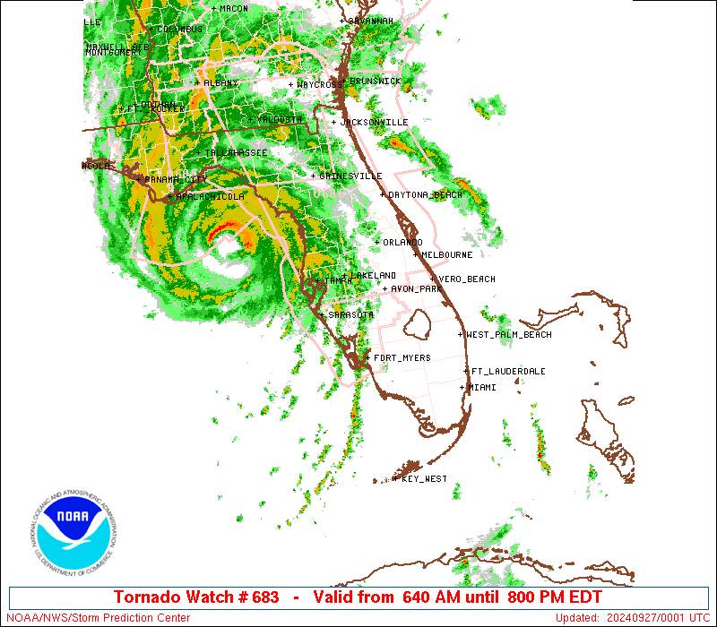
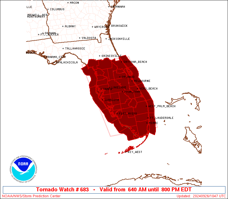
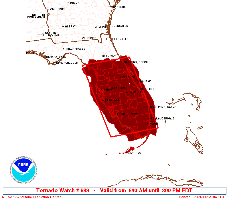
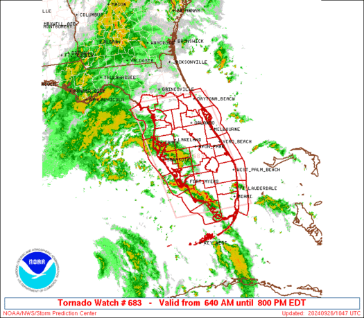
Tornado Watch Number 683
NWS Storm Prediction Center Norman OK
640 AM EDT Thu Sep 26 2024
The NWS Storm Prediction Center has issued a
* Tornado Watch for portions of
Florida Peninsula
Coastal Waters
* Effective this Thursday morning and evening from 640 AM until
800 PM EDT.
* Primary threats include...
Several tornadoes likely
SUMMARY...In association with a strengthening Hurricane Helene,
conditions will become increasingly favorable for tornadoes today
across portions of the Florida Peninsula, in the presence of a very
moist air mass and strengthening low-level shear.
The tornado watch area is approximately along and 85 statute miles
east and west of a line from 20 miles northeast of Ocala FL to 55
miles west southwest of Miami FL. For a complete depiction of the
watch see the associated watch outline update (WOUS64 KWNS WOU3).
PRECAUTIONARY/PREPAREDNESS ACTIONS...
REMEMBER...A Tornado Watch means conditions are favorable for
tornadoes and severe thunderstorms in and close to the watch
area. Persons in these areas should be on the lookout for
threatening weather conditions and listen for later statements
and possible warnings.
&&
AVIATION...Tornadoes and a few severe thunderstorms with hail
surface and aloft to 0 inches. Extreme turbulence and surface wind
gusts to 60 knots. A few cumulonimbi with maximum tops to 500. Mean
storm motion vector 16050.
...Guyer
   SEL3

   URGENT - IMMEDIATE BROADCAST REQUESTED
   Tornado Watch Number 683
   NWS Storm Prediction Center Norman OK
   640 AM EDT Thu Sep 26 2024

   The NWS Storm Prediction Center has issued a

   * Tornado Watch for portions of
     Florida Peninsula
     Coastal Waters

   * Effective this Thursday morning and evening from 640 AM until
     800 PM EDT.

   * Primary threats include...
     Several tornadoes likely

   SUMMARY...In association with a strengthening Hurricane Helene,
   conditions will become increasingly favorable for tornadoes today
   across portions of the Florida Peninsula, in the presence of a very
   moist air mass and strengthening low-level shear.

   The tornado watch area is approximately along and 85 statute miles
   east and west of a line from 20 miles northeast of Ocala FL to 55
   miles west southwest of Miami FL. For a complete depiction of the
   watch see the associated watch outline update (WOUS64 KWNS WOU3).

   PRECAUTIONARY/PREPAREDNESS ACTIONS...

   REMEMBER...A Tornado Watch means conditions are favorable for
   tornadoes and severe thunderstorms in and close to the watch
   area. Persons in these areas should be on the lookout for
   threatening weather conditions and listen for later statements
   and possible warnings.

   &&

   AVIATION...Tornadoes and a few severe thunderstorms with hail
   surface and aloft to 0 inches. Extreme turbulence and surface wind
   gusts to 60 knots. A few cumulonimbi with maximum tops to 500. Mean
   storm motion vector 16050.

   ...Guyer
 Note:
The Aviation Watch (SAW) product is an approximation to the watch area.
The actual watch is depicted by the shaded areas.
Note:
The Aviation Watch (SAW) product is an approximation to the watch area.
The actual watch is depicted by the shaded areas.
   SAW3
   WW 683 TORNADO FL CW 261040Z - 270000Z
   AXIS..85 STATUTE MILES EAST AND WEST OF LINE..
   20NE OCF/OCALA FL/ - 55WSW MIA/MIAMI FL/
   ..AVIATION COORDS.. 75NM E/W /46W OMN - 47WSW MIA/
   WIND GUSTS..60 KNOTS.
   MAX TOPS TO 500.MEAN STORM MOTION VECTOR 16050.

   LAT...LON 29378057 25497973 25498246 29378340

   THIS IS AN APPROXIMATION TO THE WATCH AREA.  FOR A
   COMPLETE DEPICTION OF THE WATCH SEE WOUS64 KWNS
   FOR WOU3.
Watch 683 Status Report Messages:
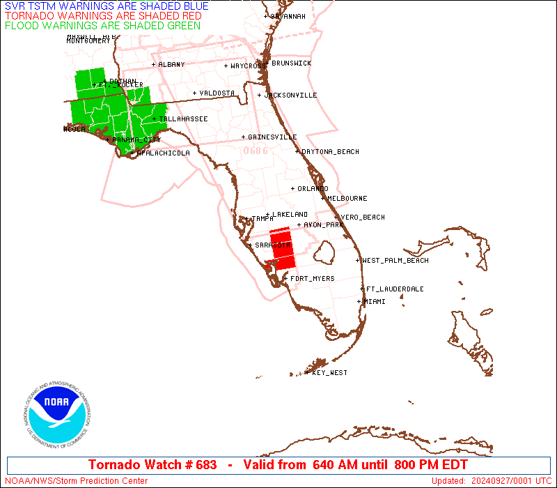
STATUS REPORT #2 ON WW 683

VALID 261850Z - 261940Z

THE SEVERE WEATHER THREAT CONTINUES ACROSS THE ENTIRE WATCH AREA.

..GOSS..09/26/24

ATTN...WFO...MLB...MFL...TBW...JAX...

&&

STATUS REPORT FOR WT 683

SEVERE WEATHER THREAT CONTINUES FOR THE FOLLOWING AREAS

FLC009-011-015-017-021-027-043-049-051-053-055-057-061-069-071-
075-081-083-085-086-087-093-095-097-099-101-103-105-111-115-117-
119-127-261940-

FL
.    FLORIDA COUNTIES INCLUDED ARE

BREVARD 	     BROWARD		 CHARLOTTE
CITRUS		     COLLIER		 DESOTO
GLADES		     HARDEE		 HENDRY
HERNANDO	     HIGHLANDS		 HILLSBOROUGH
INDIAN RIVER	     LAKE		 LEE
LEVY		     MANATEE		 MARION
MARTIN		     MIAMI-DADE 	 MONROE
OKEECHOBEE	     ORANGE		 OSCEOLA
PALM BEACH	     PASCO		 PINELLAS
POLK		     ST. LUCIE		 SARASOTA
SEMINOLE	     SUMTER		 VOLUSIA
$$


AMZ550-552-555-610-630-650-651-GMZ656-657-830-836-850-853-856-
261940-

CW

.    ADJACENT COASTAL WATERS INCLUDED ARE

FLAGLER BEACH TO VOLUSIA-BREVARD COUNTY LINE 0-20 NM

VOLUSIA-BREVARD COUNTY LINE TO SEBASTIAN INLET 0-20 NM

SEBASTIAN INLET TO JUPITER INLET 0-20 NM

LAKE OKEECHOBEE

BISCAYNE BAY

COASTAL WATERS FROM JUPITER INLET TO DEERFIELD BEACH FL OUT 20 NM

COASTAL WATERS FROM DEERFIELD BEACH TO OCEAN REEF FL OUT 20 NM

COASTAL WATERS FROM CHOKOLOSKEE TO BONITA BEACH FL OUT 20 NM

COASTAL WATERS FROM EAST CAPE SABLE TO CHOKOLOSKEE FL OUT 20 NM

TAMPA BAY WATERS

CHARLOTTE HARBOR AND PINE ISLAND SOUND

COASTAL WATERS FROM TARPON SPRINGS TO SUWANNEE RIVER FL OUT 20 NM

COASTAL WATERS FROM ENGLEWOOD TO TARPON SPRINGS FL OUT 20 NM

COASTAL WATERS FROM BONITA BEACH TO ENGLEWOOD FL OUT 20 NM

$$
THE WATCH STATUS MESSAGE IS FOR GUIDANCE PURPOSES ONLY.  PLEASE
REFER TO WATCH COUNTY NOTIFICATION STATEMENTS FOR OFFICIAL
INFORMATION ON COUNTIES...INDEPENDENT CITIES AND MARINE ZONES
CLEARED FROM SEVERE THUNDERSTORM AND TORNADO WATCHES.
$$

STATUS REPORT #1 ON WW 683

VALID 261235Z - 261340Z

THE SEVERE WEATHER THREAT CONTINUES ACROSS THE ENTIRE WATCH AREA.

..BROYLES..09/26/24

ATTN...WFO...MLB...MFL...TBW...JAX...

&&

STATUS REPORT FOR WT 683

SEVERE WEATHER THREAT CONTINUES FOR THE FOLLOWING AREAS

FLC009-011-015-017-021-027-043-049-051-053-055-057-061-069-071-
075-081-083-085-086-087-093-095-097-099-101-103-105-111-115-117-
119-127-261340-

FL
.    FLORIDA COUNTIES INCLUDED ARE

BREVARD 	     BROWARD		 CHARLOTTE
CITRUS		     COLLIER		 DESOTO
GLADES		     HARDEE		 HENDRY
HERNANDO	     HIGHLANDS		 HILLSBOROUGH
INDIAN RIVER	     LAKE		 LEE
LEVY		     MANATEE		 MARION
MARTIN		     MIAMI-DADE 	 MONROE
OKEECHOBEE	     ORANGE		 OSCEOLA
PALM BEACH	     PASCO		 PINELLAS
POLK		     ST. LUCIE		 SARASOTA
SEMINOLE	     SUMTER		 VOLUSIA
$$


AMZ550-552-555-610-630-650-651-GMZ656-657-830-836-850-853-856-
261340-

CW

.    ADJACENT COASTAL WATERS INCLUDED ARE

FLAGLER BEACH TO VOLUSIA-BREVARD COUNTY LINE 0-20 NM

VOLUSIA-BREVARD COUNTY LINE TO SEBASTIAN INLET 0-20 NM

SEBASTIAN INLET TO JUPITER INLET 0-20 NM

LAKE OKEECHOBEE

BISCAYNE BAY

COASTAL WATERS FROM JUPITER INLET TO DEERFIELD BEACH FL OUT 20 NM

COASTAL WATERS FROM DEERFIELD BEACH TO OCEAN REEF FL OUT 20 NM

COASTAL WATERS FROM CHOKOLOSKEE TO BONITA BEACH FL OUT 20 NM

COASTAL WATERS FROM EAST CAPE SABLE TO CHOKOLOSKEE FL OUT 20 NM

TAMPA BAY WATERS

CHARLOTTE HARBOR AND PINE ISLAND SOUND

COASTAL WATERS FROM TARPON SPRINGS TO SUWANNEE RIVER FL OUT 20 NM

COASTAL WATERS FROM ENGLEWOOD TO TARPON SPRINGS FL OUT 20 NM

COASTAL WATERS FROM BONITA BEACH TO ENGLEWOOD FL OUT 20 NM

$$
THE WATCH STATUS MESSAGE IS FOR GUIDANCE PURPOSES ONLY.  PLEASE
REFER TO WATCH COUNTY NOTIFICATION STATEMENTS FOR OFFICIAL
INFORMATION ON COUNTIES...INDEPENDENT CITIES AND MARINE ZONES
CLEARED FROM SEVERE THUNDERSTORM AND TORNADO WATCHES.
$$
Note:
Click for Complete Product Text.
Tornadoes
Probability of 2 or more tornadoes
|
High (80%)
|
Probability of 1 or more strong (EF2-EF5) tornadoes
|
Low (20%)
|
Wind
Probability of 10 or more severe wind events
|
Low (10%)
|
Probability of 1 or more wind events > 65 knots
|
Low (10%)
|
Hail
Probability of 10 or more severe hail events
|
Low (<5%)
|
Probability of 1 or more hailstones > 2 inches
|
Low (<5%)
|
Combined Severe Hail/Wind
Probability of 6 or more combined severe hail/wind events
|
Low (20%)
|
For each watch, probabilities for particular events inside the watch
(listed above in each table) are determined by the issuing forecaster.
The "Low" category contains probability values ranging from less than 2%
to 20% (EF2-EF5 tornadoes), less than 5% to 20% (all other probabilities),
"Moderate" from 30% to 60%, and "High" from 70% to greater than 95%.
High values are bolded and lighter in color to provide awareness of
an increased threat for a particular event.


 @NWSSPC