 Note:
The expiration time in the watch graphic is amended if the watch is
replaced, cancelled or extended.
Note:
Note:
The expiration time in the watch graphic is amended if the watch is
replaced, cancelled or extended.
Note: Click for
Watch Status Reports.
SEL0
URGENT - IMMEDIATE BROADCAST REQUESTED
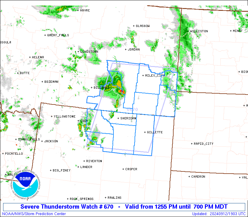
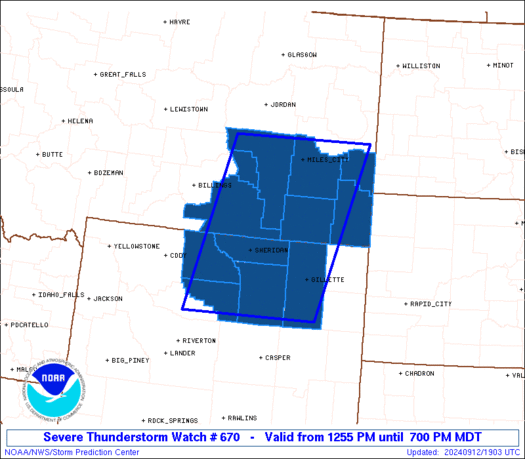
Severe Thunderstorm Watch Number 670
NWS Storm Prediction Center Norman OK
1255 PM MDT Thu Sep 12 2024
The NWS Storm Prediction Center has issued a
* Severe Thunderstorm Watch for portions of
Southeast Montana
Northeast Wyoming
* Effective this Thursday afternoon and evening from 1255 PM
until 700 PM MDT.
* Primary threats include...
Scattered damaging winds likely with isolated significant gusts
to 75 mph possible
Scattered large hail events to 1.5 inches in diameter possible
A tornado or two possible
SUMMARY...At least widely scattered severe storms including
supercells will initially develop generally near the Montana/Wyoming
border vicinity this afternoon, spreading northeastward through the
afternoon.
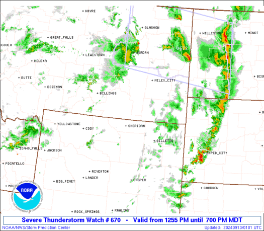
The severe thunderstorm watch area is approximately along and 80
statute miles east and west of a line from 60 miles east southeast
of Worland WY to 25 miles north of Miles City MT. For a complete
depiction of the watch see the associated watch outline update
(WOUS64 KWNS WOU0).
PRECAUTIONARY/PREPAREDNESS ACTIONS...
REMEMBER...A Severe Thunderstorm Watch means conditions are
favorable for severe thunderstorms in and close to the watch area.
Persons in these areas should be on the lookout for threatening
weather conditions and listen for later statements and possible
warnings. Severe thunderstorms can and occasionally do produce
tornadoes.
&&
AVIATION...A few severe thunderstorms with hail surface and aloft to
1.5 inches. Extreme turbulence and surface wind gusts to 65 knots. A
few cumulonimbi with maximum tops to 450. Mean storm motion vector
22040.
...Guyer

   SEL0

   URGENT - IMMEDIATE BROADCAST REQUESTED
   Severe Thunderstorm Watch Number 670
   NWS Storm Prediction Center Norman OK
   1255 PM MDT Thu Sep 12 2024

   The NWS Storm Prediction Center has issued a

   * Severe Thunderstorm Watch for portions of
     Southeast Montana
     Northeast Wyoming

   * Effective this Thursday afternoon and evening from 1255 PM
     until 700 PM MDT.

   * Primary threats include...
     Scattered damaging winds likely with isolated significant gusts
       to 75 mph possible
     Scattered large hail events to 1.5 inches in diameter possible
     A tornado or two possible

   SUMMARY...At least widely scattered severe storms including
   supercells will initially develop generally near the Montana/Wyoming
   border vicinity this afternoon, spreading northeastward through the
   afternoon.

   The severe thunderstorm watch area is approximately along and 80
   statute miles east and west of a line from 60 miles east southeast
   of Worland WY to 25 miles north of Miles City MT. For a complete
   depiction of the watch see the associated watch outline update
   (WOUS64 KWNS WOU0).

   PRECAUTIONARY/PREPAREDNESS ACTIONS...

   REMEMBER...A Severe Thunderstorm Watch means conditions are
   favorable for severe thunderstorms in and close to the watch area.
   Persons in these areas should be on the lookout for threatening
   weather conditions and listen for later statements and possible
   warnings. Severe thunderstorms can and occasionally do produce
   tornadoes.

   &&

   AVIATION...A few severe thunderstorms with hail surface and aloft to
   1.5 inches. Extreme turbulence and surface wind gusts to 65 knots. A
   few cumulonimbi with maximum tops to 450. Mean storm motion vector
   22040.

   ...Guyer
 Note:
The Aviation Watch (SAW) product is an approximation to the watch area.
The actual watch is depicted by the shaded areas.
Note:
The Aviation Watch (SAW) product is an approximation to the watch area.
The actual watch is depicted by the shaded areas.
SAW0
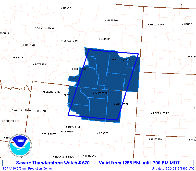
WW 670 SEVERE TSTM MT WY 121855Z - 130100Z
AXIS..80 STATUTE MILES EAST AND WEST OF LINE..
60ESE WRL/WORLAND WY/ - 25N MLS/MILES CITY MT/
..AVIATION COORDS.. 70NM E/W /29SW CZI - 25N MLS/
HAIL SURFACE AND ALOFT..1.5 INCHES. WIND GUSTS..65 KNOTS.
MAX TOPS TO 450. MEAN STORM MOTION VECTOR 22040.
LAT...LON 43620846 46780757 46780419 43620526
THIS IS AN APPROXIMATION TO THE WATCH AREA. FOR A
COMPLETE DEPICTION OF THE WATCH SEE WOUS64 KWNS
FOR WOU0.
Watch 670 Status Report Messages:
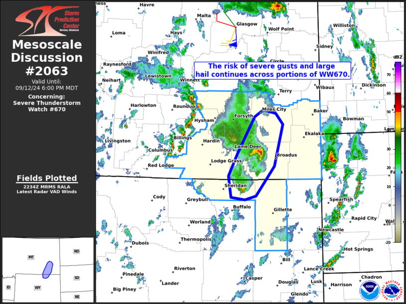
STATUS REPORT #1 ON WW 670

VALID 122150Z - 122240Z

SEVERE WEATHER THREAT CONTINUES RIGHT OF A LINE FROM 45 NE CPR TO
25 SW GCC TO 25 WNW GCC TO 30 ESE SHR TO 10 SSE SHR TO 25 W SHR
TO 55 WNW SHR TO 40 SSE BIL.

..JEWELL..09/12/24

ATTN...WFO...BYZ...RIW...UNR...

&&

STATUS REPORT FOR WS 670

SEVERE WEATHER THREAT CONTINUES FOR THE FOLLOWING AREAS

MTC003-011-017-025-075-087-103-122240-

MT
.    MONTANA COUNTIES INCLUDED ARE

BIG HORN	     CARTER		 CUSTER
FALLON		     POWDER RIVER	 ROSEBUD
TREASURE
$$


WYC005-033-122240-

WY
.    WYOMING COUNTIES INCLUDED ARE

CAMPBELL	     SHERIDAN
$$


THE WATCH STATUS MESSAGE IS FOR GUIDANCE PURPOSES ONLY.  PLEASE
REFER TO WATCH COUNTY NOTIFICATION STATEMENTS FOR OFFICIAL
INFORMATION ON COUNTIES...INDEPENDENT CITIES AND MARINE ZONES
CLEARED FROM SEVERE THUNDERSTORM AND TORNADO WATCHES.
$$
Note:
Click for Complete Product Text.
Tornadoes
Probability of 2 or more tornadoes
|
Low (20%)
|
Probability of 1 or more strong (EF2-EF5) tornadoes
|
Low (<2%)
|
Wind
Probability of 10 or more severe wind events
|
Mod (60%)
|
Probability of 1 or more wind events > 65 knots
|
Mod (50%)
|
Hail
Probability of 10 or more severe hail events
|
Mod (40%)
|
Probability of 1 or more hailstones > 2 inches
|
Low (20%)
|
Combined Severe Hail/Wind
Probability of 6 or more combined severe hail/wind events
|
High (90%)
|
For each watch, probabilities for particular events inside the watch
(listed above in each table) are determined by the issuing forecaster.
The "Low" category contains probability values ranging from less than 2%
to 20% (EF2-EF5 tornadoes), less than 5% to 20% (all other probabilities),
"Moderate" from 30% to 60%, and "High" from 70% to greater than 95%.
High values are bolded and lighter in color to provide awareness of
an increased threat for a particular event.


 @NWSSPC