 Note:
The expiration time in the watch graphic is amended if the watch is
replaced, cancelled or extended.
Note:
Note:
The expiration time in the watch graphic is amended if the watch is
replaced, cancelled or extended.
Note: Click for
Watch Status Reports.
SEL9
URGENT - IMMEDIATE BROADCAST REQUESTED
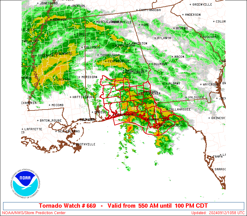
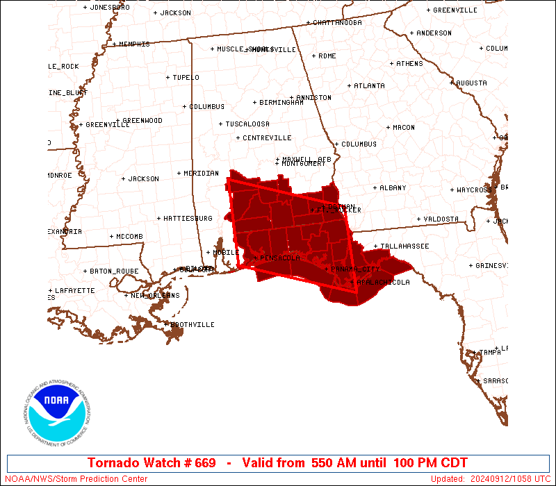
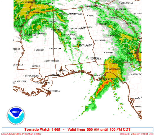
Tornado Watch Number 669
NWS Storm Prediction Center Norman OK
550 AM CDT Thu Sep 12 2024
The NWS Storm Prediction Center has issued a
* Tornado Watch for portions of
Southern Alabama
Florida Panhandle
Coastal Waters
* Effective this Thursday morning and afternoon from 550 AM until
100 PM CDT.
* Primary threats include...
A few tornadoes possible
SUMMARY...As Francine's center continues moving northward over MS
and weakens further through midday (per NHC forecast), a slot of
wind/moisture/instability fields favorable for supercells and a few
tornadoes will shift slowly northward/inland as well.
The tornado watch area is approximately along and 60 statute miles
north and south of a line from 35 miles west southwest of Evergreen
AL to 35 miles south southeast of Marianna FL. For a complete
depiction of the watch see the associated watch outline update
(WOUS64 KWNS WOU9).
PRECAUTIONARY/PREPAREDNESS ACTIONS...
REMEMBER...A Tornado Watch means conditions are favorable for
tornadoes and severe thunderstorms in and close to the watch
area. Persons in these areas should be on the lookout for
threatening weather conditions and listen for later statements
and possible warnings.
&&
OTHER WATCH INFORMATION...This tornado watch replaces tornado
watch number 668. Watch number 668 will not be in effect after
550 AM CDT.
AVIATION...Tornadoes and a few severe thunderstorms with hail
surface and aloft to 0 inches. Extreme turbulence and surface wind
gusts to 50 knots. A few cumulonimbi with maximum tops to 450. Mean
storm motion vector 16030.
...Edwards

   SEL9

   URGENT - IMMEDIATE BROADCAST REQUESTED
   Tornado Watch Number 669
   NWS Storm Prediction Center Norman OK
   550 AM CDT Thu Sep 12 2024

   The NWS Storm Prediction Center has issued a

   * Tornado Watch for portions of
     Southern Alabama
     Florida Panhandle
     Coastal Waters

   * Effective this Thursday morning and afternoon from 550 AM until
     100 PM CDT.

   * Primary threats include...
     A few tornadoes possible

   SUMMARY...As Francine's center continues moving northward over MS
   and weakens further through midday (per NHC forecast), a slot of
   wind/moisture/instability fields favorable for supercells and a few
   tornadoes will shift slowly northward/inland as well.

   The tornado watch area is approximately along and 60 statute miles
   north and south of a line from 35 miles west southwest of Evergreen
   AL to 35 miles south southeast of Marianna FL. For a complete
   depiction of the watch see the associated watch outline update
   (WOUS64 KWNS WOU9).

   PRECAUTIONARY/PREPAREDNESS ACTIONS...

   REMEMBER...A Tornado Watch means conditions are favorable for
   tornadoes and severe thunderstorms in and close to the watch
   area. Persons in these areas should be on the lookout for
   threatening weather conditions and listen for later statements
   and possible warnings.

   &&

   OTHER WATCH INFORMATION...This tornado watch replaces tornado
   watch number 668. Watch number 668 will not be in effect after
   550 AM CDT.

   AVIATION...Tornadoes and a few severe thunderstorms with hail
   surface and aloft to 0 inches. Extreme turbulence and surface wind
   gusts to 50 knots. A few cumulonimbi with maximum tops to 450. Mean
   storm motion vector 16030.

   ...Edwards
 Note:
The Aviation Watch (SAW) product is an approximation to the watch area.
The actual watch is depicted by the shaded areas.
Note:
The Aviation Watch (SAW) product is an approximation to the watch area.
The actual watch is depicted by the shaded areas.
   SAW9
   WW 669 TORNADO AL FL CW 121050Z - 121800Z
   AXIS..60 STATUTE MILES NORTH AND SOUTH OF LINE..
   35WSW GZH/EVERGREEN AL/ - 35SSE MAI/MARIANNA FL/
   ..AVIATION COORDS.. 50NM N/S /50NE SJI - 32WSW TLH/
   WIND GUSTS..50 KNOTS.
   MAX TOPS TO 450.MEAN STORM MOTION VECTOR 16030.

   REPLACES WW 668..AL FL LA MS CW

   LAT...LON 32098759 31258496 29518496 30368759

   THIS IS AN APPROXIMATION TO THE WATCH AREA.  FOR A
   COMPLETE DEPICTION OF THE WATCH SEE WOUS64 KWNS
   FOR WOU9.
Watch 669 Status Report Messages:
STATUS REPORT #4 ON WW 669
VALID 121800Z - 121800Z
SEVERE WEATHER THREAT CONTINUES RIGHT OF A LINE FROM 40 WSW AAF
TO 15 W TLH.
WW 669 WILL BE ALLOWED TO EXPIRE AT 121800Z.
..DEAN..09/12/24
ATTN...WFO...MOB...TAE...
&&
STATUS REPORT FOR WT 669
SEVERE WEATHER THREAT CONTINUES FOR THE FOLLOWING AREAS
FLC037-129-121800-
FL
. FLORIDA COUNTIES INCLUDED ARE
FRANKLIN WAKULLA
$$
GMZ633-730-755-121800-
CW
. ADJACENT COASTAL WATERS INCLUDED ARE
PERDIDO BAY AREA
APALACHEE BAY OR COASTAL WATERS FROM KEATON BEACH TO OCHLOCKONEE
RIVER FL OUT TO 20 NM
COASTAL WATERS FROM OCHLOCKONEE RIVER TO APALACHICOLA FL OUT TO
20 NM
$$
THE WATCH STATUS MESSAGE IS FOR GUIDANCE PURPOSES ONLY. PLEASE
REFER TO WATCH COUNTY NOTIFICATION STATEMENTS FOR OFFICIAL
INFORMATION ON COUNTIES...INDEPENDENT CITIES AND MARINE ZONES
CLEARED FROM SEVERE THUNDERSTORM AND TORNADO WATCHES.
$$
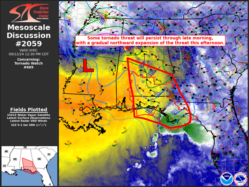
STATUS REPORT #3 ON WW 669
VALID 121530Z - 121640Z
THE SEVERE WEATHER THREAT CONTINUES ACROSS THE ENTIRE WATCH AREA.
FOR ADDITIONAL INFORMATION SEE MESOSCALE DISCUSSION 2059
..DEAN..09/12/24
ATTN...WFO...MOB...TAE...
&&
STATUS REPORT FOR WT 669
SEVERE WEATHER THREAT CONTINUES FOR THE FOLLOWING AREAS
ALC013-031-035-039-041-045-053-061-067-069-099-131-121640-
AL
. ALABAMA COUNTIES INCLUDED ARE
BUTLER COFFEE CONECUH
COVINGTON CRENSHAW DALE
ESCAMBIA GENEVA HENRY
HOUSTON MONROE WILCOX
$$
FLC005-013-033-037-045-059-063-077-091-113-129-131-133-121640-
FL
. FLORIDA COUNTIES INCLUDED ARE
BAY CALHOUN ESCAMBIA
FRANKLIN GULF HOLMES
JACKSON LIBERTY OKALOOSA
SANTA ROSA WAKULLA WALTON
WASHINGTON
$$
GMZ633-634-635-636-655-730-750-752-755-121640-
CW
. ADJACENT COASTAL WATERS INCLUDED ARE
PERDIDO BAY AREA
PENSACOLA BAY AREA INCLUDING SANTA ROSA SOUND
WESTERN CHOCTAWHATCHEE BAY
EASTERN CHOCTAWHATCHEE BAY
COASTAL WATERS FROM OKALOOSA-WALTON COUNTY LINE TO PENSACOLA FL
OUT 20 NM
APALACHEE BAY OR COASTAL WATERS FROM KEATON BEACH TO OCHLOCKONEE
RIVER FL OUT TO 20 NM
COASTAL WATERS FROM OKALOOSA-WALTON COUNTY LINE TO MEXICO BEACH
OUT 20 NM
COASTAL WATERS FROM MEXICO BEACH TO APALACHICOLA OUT 20 NM
COASTAL WATERS FROM OCHLOCKONEE RIVER TO APALACHICOLA FL OUT TO
20 NM
$$
THE WATCH STATUS MESSAGE IS FOR GUIDANCE PURPOSES ONLY. PLEASE
REFER TO WATCH COUNTY NOTIFICATION STATEMENTS FOR OFFICIAL
INFORMATION ON COUNTIES...INDEPENDENT CITIES AND MARINE ZONES
CLEARED FROM SEVERE THUNDERSTORM AND TORNADO WATCHES.
$$
STATUS REPORT #2 ON WW 669
VALID 121340Z - 121440Z
THE SEVERE WEATHER THREAT CONTINUES ACROSS THE ENTIRE WATCH AREA.
..DEAN..09/12/24
ATTN...WFO...MOB...TAE...
&&
STATUS REPORT FOR WT 669
SEVERE WEATHER THREAT CONTINUES FOR THE FOLLOWING AREAS
ALC013-031-035-039-041-045-053-061-067-069-099-131-121440-
AL
. ALABAMA COUNTIES INCLUDED ARE
BUTLER COFFEE CONECUH
COVINGTON CRENSHAW DALE
ESCAMBIA GENEVA HENRY
HOUSTON MONROE WILCOX
$$
FLC005-013-033-037-045-059-063-077-091-113-129-131-133-121440-
FL
. FLORIDA COUNTIES INCLUDED ARE
BAY CALHOUN ESCAMBIA
FRANKLIN GULF HOLMES
JACKSON LIBERTY OKALOOSA
SANTA ROSA WAKULLA WALTON
WASHINGTON
$$
GMZ633-634-635-636-655-730-750-752-755-121440-
CW
. ADJACENT COASTAL WATERS INCLUDED ARE
PERDIDO BAY AREA
PENSACOLA BAY AREA INCLUDING SANTA ROSA SOUND
WESTERN CHOCTAWHATCHEE BAY
EASTERN CHOCTAWHATCHEE BAY
COASTAL WATERS FROM OKALOOSA-WALTON COUNTY LINE TO PENSACOLA FL
OUT 20 NM
APALACHEE BAY OR COASTAL WATERS FROM KEATON BEACH TO OCHLOCKONEE
RIVER FL OUT TO 20 NM
COASTAL WATERS FROM OKALOOSA-WALTON COUNTY LINE TO MEXICO BEACH
OUT 20 NM
COASTAL WATERS FROM MEXICO BEACH TO APALACHICOLA OUT 20 NM
COASTAL WATERS FROM OCHLOCKONEE RIVER TO APALACHICOLA FL OUT TO
20 NM
$$
THE WATCH STATUS MESSAGE IS FOR GUIDANCE PURPOSES ONLY. PLEASE
REFER TO WATCH COUNTY NOTIFICATION STATEMENTS FOR OFFICIAL
INFORMATION ON COUNTIES...INDEPENDENT CITIES AND MARINE ZONES
CLEARED FROM SEVERE THUNDERSTORM AND TORNADO WATCHES.
$$
STATUS REPORT #1 ON WW 669
VALID 121225Z - 121340Z
THE SEVERE WEATHER THREAT CONTINUES ACROSS THE ENTIRE WATCH AREA.
..KERR..09/12/24
ATTN...WFO...MOB...TAE...
&&
STATUS REPORT FOR WT 669
SEVERE WEATHER THREAT CONTINUES FOR THE FOLLOWING AREAS
ALC013-031-035-039-041-045-053-061-067-069-099-131-121340-
AL
. ALABAMA COUNTIES INCLUDED ARE
BUTLER COFFEE CONECUH
COVINGTON CRENSHAW DALE
ESCAMBIA GENEVA HENRY
HOUSTON MONROE WILCOX
$$
FLC005-013-033-037-045-059-063-077-091-113-129-131-133-121340-
FL
. FLORIDA COUNTIES INCLUDED ARE
BAY CALHOUN ESCAMBIA
FRANKLIN GULF HOLMES
JACKSON LIBERTY OKALOOSA
SANTA ROSA WAKULLA WALTON
WASHINGTON
$$
GMZ633-634-635-636-655-730-750-752-755-121340-
CW
. ADJACENT COASTAL WATERS INCLUDED ARE
PERDIDO BAY AREA
PENSACOLA BAY AREA INCLUDING SANTA ROSA SOUND
WESTERN CHOCTAWHATCHEE BAY
EASTERN CHOCTAWHATCHEE BAY
COASTAL WATERS FROM OKALOOSA-WALTON COUNTY LINE TO PENSACOLA FL
OUT 20 NM
APALACHEE BAY OR COASTAL WATERS FROM KEATON BEACH TO OCHLOCKONEE
RIVER FL OUT TO 20 NM
COASTAL WATERS FROM OKALOOSA-WALTON COUNTY LINE TO MEXICO BEACH
OUT 20 NM
COASTAL WATERS FROM MEXICO BEACH TO APALACHICOLA OUT 20 NM
COASTAL WATERS FROM OCHLOCKONEE RIVER TO APALACHICOLA FL OUT TO
20 NM
$$
THE WATCH STATUS MESSAGE IS FOR GUIDANCE PURPOSES ONLY. PLEASE
REFER TO WATCH COUNTY NOTIFICATION STATEMENTS FOR OFFICIAL
INFORMATION ON COUNTIES...INDEPENDENT CITIES AND MARINE ZONES
CLEARED FROM SEVERE THUNDERSTORM AND TORNADO WATCHES.
$$
Note:
Click for Complete Product Text.
Tornadoes
Probability of 2 or more tornadoes
|
Mod (50%)
|
Probability of 1 or more strong (EF2-EF5) tornadoes
|
Low (20%)
|
Wind
Probability of 10 or more severe wind events
|
Low (<5%)
|
Probability of 1 or more wind events > 65 knots
|
Low (<5%)
|
Hail
Probability of 10 or more severe hail events
|
Low (<5%)
|
Probability of 1 or more hailstones > 2 inches
|
Low (<5%)
|
Combined Severe Hail/Wind
Probability of 6 or more combined severe hail/wind events
|
Low (20%)
|
For each watch, probabilities for particular events inside the watch
(listed above in each table) are determined by the issuing forecaster.
The "Low" category contains probability values ranging from less than 2%
to 20% (EF2-EF5 tornadoes), less than 5% to 20% (all other probabilities),
"Moderate" from 30% to 60%, and "High" from 70% to greater than 95%.
High values are bolded and lighter in color to provide awareness of
an increased threat for a particular event.


 @NWSSPC