|
| Mesoscale Discussion 2063 |
|
< Previous MD Next MD >
|
|
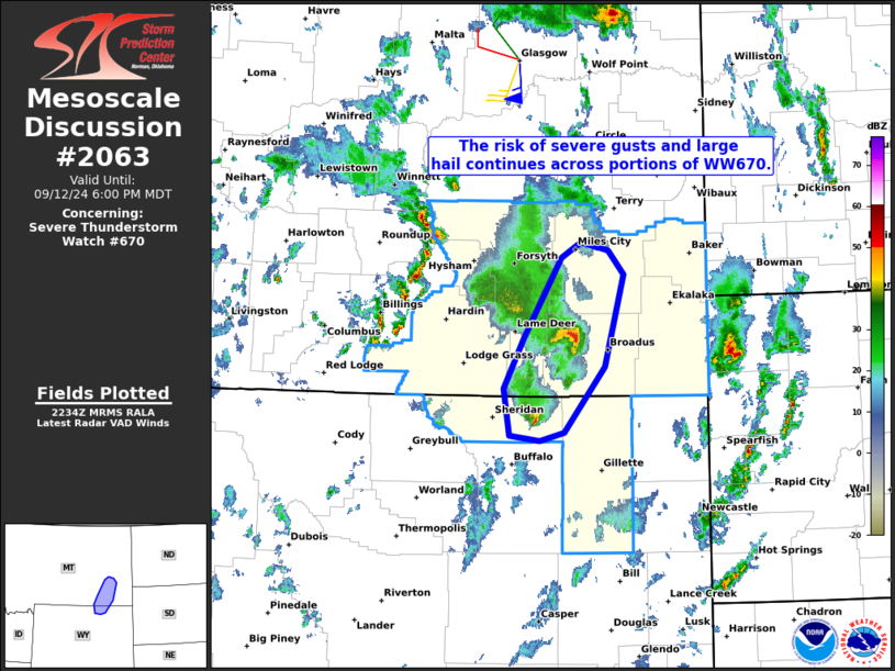
   Mesoscale Discussion 2063
   NWS Storm Prediction Center Norman OK
   0536 PM CDT Thu Sep 12 2024

   Areas affected...portions of northeastern Wyoming and southeastern
   Montana

   Concerning...Severe Thunderstorm Watch 670...

   Valid 122236Z - 130000Z

   The severe weather threat for Severe Thunderstorm Watch 670
   continues.

   SUMMARY...The risk of severe gusts and isolated large hail continues
   across portions of Severe Thunderstorm Watch 670.

   DISCUSSION...Latest radar data from KBLX depicts a
   north/south-oriented band of organized thunderstorms (including a
   semi-discrete supercell structures and a small bowing segment)
   tracking northward across portions of northeastern WY and
   southeastern MT. One of these supercells produced 2-inch hail near
   Sheridan WY at around 21Z. A long/straight hodograph (around 60 kt
   of deep-layer shear per RIW VWP) and weak (albeit sufficient)
   surface-based buoyancy will continue to support semi-discrete
   supercells and small bowing structures, capable of producing severe
   gusts and isolated large hail. As strong large-scale ascent within
   the left-exit region of a midlevel jet continues to cross the area,
   there may be some tendency for localized upscale growth and an
   increasing severe-wind risk (aided by steep midlevel lapse rates and
   the strong deep-layer flow/shear). Severe gusts of 70-80 mph are
   possible with any upscale-grown convection.

   ..Weinman.. 09/12/2024

   ...Please see www.spc.noaa.gov for graphic product...

   ATTN...WFO...UNR...BYZ...

   LAT...LON   44620673 45060681 45540654 46310602 46460576 46390538
               46160517 45280544 44650599 44570631 44620673
|
|
Top/All Mesoscale Discussions/Forecast Products/Home
|
|


 @NWSSPC