 Note:
The expiration time in the watch graphic is amended if the watch is
replaced, cancelled or extended.
Note:
Note:
The expiration time in the watch graphic is amended if the watch is
replaced, cancelled or extended.
Note: Click for
Watch Status Reports.
SEL0
URGENT - IMMEDIATE BROADCAST REQUESTED
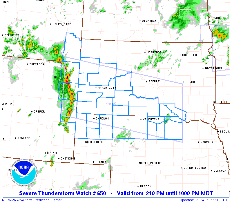
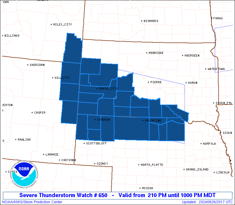
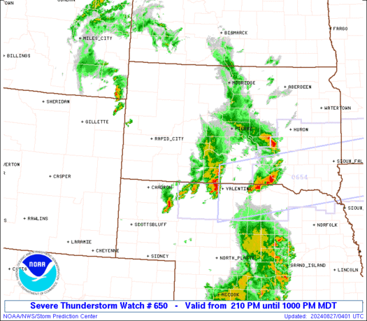
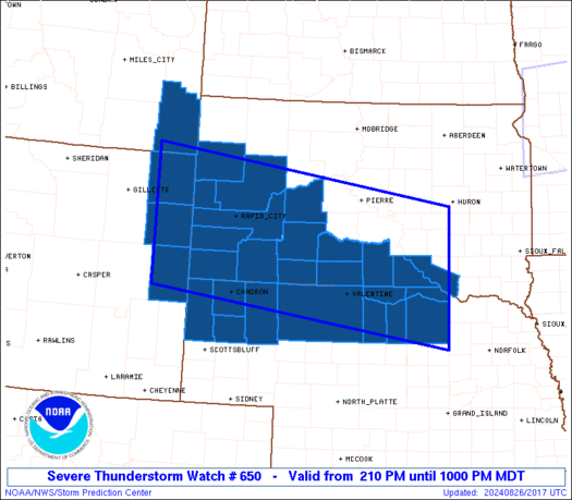
Severe Thunderstorm Watch Number 650
NWS Storm Prediction Center Norman OK
210 PM MDT Mon Aug 26 2024
The NWS Storm Prediction Center has issued a
* Severe Thunderstorm Watch for portions of
Far Southeast Montana
Northern Nebraska
Western and Southern South Dakota
Northeast Wyoming
* Effective this Monday afternoon and evening from 210 PM until
1000 PM MDT.
* Primary threats include...
Scattered damaging winds and isolated significant gusts to 80
mph likely
Scattered large hail and isolated very large hail events to 2.5
inches in diameter likely
A tornado or two possible
SUMMARY...Strong to severe thunderstorms including supercells will
continue to develop this afternoon across northeast Wyoming/far
southeast Montana into western South Dakota, with additional and
more isolated development possible along the South Dakota/Nebraska
border vicinity. Clusters of eastward-moving storms should evolve by
evening, potentially as a severe-wind producing linear convective
system that should move across southern South Dakota and northern
Nebraska.
The severe thunderstorm watch area is approximately along and 80
statute miles north and south of a line from 90 miles west of Rapid
City SD to 50 miles north northeast of Oneill NE. For a complete
depiction of the watch see the associated watch outline update
(WOUS64 KWNS WOU0).
PRECAUTIONARY/PREPAREDNESS ACTIONS...
REMEMBER...A Severe Thunderstorm Watch means conditions are
favorable for severe thunderstorms in and close to the watch area.
Persons in these areas should be on the lookout for threatening
weather conditions and listen for later statements and possible
warnings. Severe thunderstorms can and occasionally do produce
tornadoes.
&&
OTHER WATCH INFORMATION...CONTINUE...WW 648...WW 649...
AVIATION...A few severe thunderstorms with hail surface and aloft to
2.5 inches. Extreme turbulence and surface wind gusts to 70 knots. A
few cumulonimbi with maximum tops to 500. Mean storm motion vector
25030.
...Guyer

   SEL0

   URGENT - IMMEDIATE BROADCAST REQUESTED
   Severe Thunderstorm Watch Number 650
   NWS Storm Prediction Center Norman OK
   210 PM MDT Mon Aug 26 2024

   The NWS Storm Prediction Center has issued a

   * Severe Thunderstorm Watch for portions of
     Far Southeast Montana
     Northern Nebraska
     Western and Southern South Dakota
     Northeast Wyoming

   * Effective this Monday afternoon and evening from 210 PM until
     1000 PM MDT.

   * Primary threats include...
     Scattered damaging winds and isolated significant gusts to 80
       mph likely
     Scattered large hail and isolated very large hail events to 2.5
       inches in diameter likely
     A tornado or two possible

   SUMMARY...Strong to severe thunderstorms including supercells will
   continue to develop this afternoon across northeast Wyoming/far
   southeast Montana into western South Dakota, with additional and
   more isolated development possible along the South Dakota/Nebraska
   border vicinity. Clusters of eastward-moving storms should evolve by
   evening, potentially as a severe-wind producing linear convective
   system that should move across southern South Dakota and northern
   Nebraska.

   The severe thunderstorm watch area is approximately along and 80
   statute miles north and south of a line from 90 miles west of Rapid
   City SD to 50 miles north northeast of Oneill NE. For a complete
   depiction of the watch see the associated watch outline update
   (WOUS64 KWNS WOU0).

   PRECAUTIONARY/PREPAREDNESS ACTIONS...

   REMEMBER...A Severe Thunderstorm Watch means conditions are
   favorable for severe thunderstorms in and close to the watch area.
   Persons in these areas should be on the lookout for threatening
   weather conditions and listen for later statements and possible
   warnings. Severe thunderstorms can and occasionally do produce
   tornadoes.

   &&

   OTHER WATCH INFORMATION...CONTINUE...WW 648...WW 649...

   AVIATION...A few severe thunderstorms with hail surface and aloft to
   2.5 inches. Extreme turbulence and surface wind gusts to 70 knots. A
   few cumulonimbi with maximum tops to 500. Mean storm motion vector
   25030.

   ...Guyer
 Note:
The Aviation Watch (SAW) product is an approximation to the watch area.
The actual watch is depicted by the shaded areas.
Note:
The Aviation Watch (SAW) product is an approximation to the watch area.
The actual watch is depicted by the shaded areas.
   SAW0
   WW 650 SEVERE TSTM MT NE SD WY 262010Z - 270400Z
   AXIS..80 STATUTE MILES NORTH AND SOUTH OF LINE..
   90W RAP/RAPID CITY SD/ - 50NNE ONL/ONEILL NE/
   ..AVIATION COORDS.. 70NM N/S /68E CZI - 44NNE ONL/
   HAIL SURFACE AND ALOFT..2.5 INCHES. WIND GUSTS..70 KNOTS.
   MAX TOPS TO 500. MEAN STORM MOTION VECTOR 25030.

   LAT...LON 45190486 44309830 41989830 42880486

   THIS IS AN APPROXIMATION TO THE WATCH AREA.  FOR A
   COMPLETE DEPICTION OF THE WATCH SEE WOUS64 KWNS
   FOR WOU0.
Watch 650 Status Report Messages:
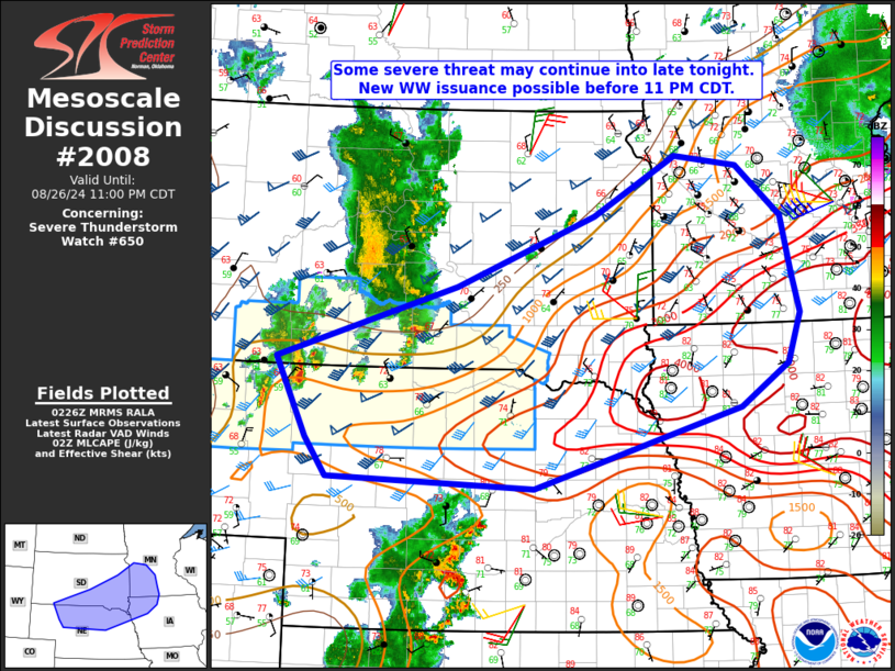
STATUS REPORT #6 ON WW 650

VALID 270305Z - 270440Z

SEVERE WEATHER THREAT CONTINUES RIGHT OF A LINE FROM 10 NNW TOR
TO 50 SSW PHP TO 15 S PHP TO 30 SW PIR.

FOR ADDITIONAL INFORMATION SEE MESOSCALE DISCUSSION 2008

..DEAN..08/27/24

ATTN...WFO...BYZ...CYS...LBF...UNR...FSD...

&&

STATUS REPORT FOR WS 650

SEVERE WEATHER THREAT CONTINUES FOR THE FOLLOWING AREAS

NEC013-015-017-031-045-089-103-149-161-165-270440-

NE
.    NEBRASKA COUNTIES INCLUDED ARE

BOX BUTTE	     BOYD		 BROWN
CHERRY		     DAWES		 HOLT
KEYA PAHA	     ROCK		 SHERIDAN
SIOUX
$$


SDC007-023-053-071-095-121-123-270440-

SD
.    SOUTH DAKOTA COUNTIES INCLUDED ARE

BENNETT 	     CHARLES MIX	 GREGORY
JACKSON 	     MELLETTE		 TODD
TRIPP
$$


THE WATCH STATUS MESSAGE IS FOR GUIDANCE PURPOSES ONLY.  PLEASE
REFER TO WATCH COUNTY NOTIFICATION STATEMENTS FOR OFFICIAL
INFORMATION ON COUNTIES...INDEPENDENT CITIES AND MARINE ZONES
CLEARED FROM SEVERE THUNDERSTORM AND TORNADO WATCHES.
$$

STATUS REPORT #5 ON WW 650

VALID 270140Z - 270240Z

SEVERE WEATHER THREAT CONTINUES RIGHT OF A LINE FROM 20 WNW TOR
TO 20 NNW CDR TO 55 NE CDR TO 25 SW PHP TO 25 N PIR.

..DEAN..08/27/24

ATTN...WFO...BYZ...CYS...LBF...UNR...FSD...

&&

STATUS REPORT FOR WS 650

SEVERE WEATHER THREAT CONTINUES FOR THE FOLLOWING AREAS

NEC013-015-017-031-045-089-103-149-161-165-270240-

NE
.    NEBRASKA COUNTIES INCLUDED ARE

BOX BUTTE	     BOYD		 BROWN
CHERRY		     DAWES		 HOLT
KEYA PAHA	     ROCK		 SHERIDAN
SIOUX
$$


SDC007-023-053-071-095-102-121-123-270240-

SD
.    SOUTH DAKOTA COUNTIES INCLUDED ARE

BENNETT 	     CHARLES MIX	 GREGORY
JACKSON 	     MELLETTE		 OGLALA LAKOTA
TODD		     TRIPP
$$


THE WATCH STATUS MESSAGE IS FOR GUIDANCE PURPOSES ONLY.  PLEASE
REFER TO WATCH COUNTY NOTIFICATION STATEMENTS FOR OFFICIAL
INFORMATION ON COUNTIES...INDEPENDENT CITIES AND MARINE ZONES
CLEARED FROM SEVERE THUNDERSTORM AND TORNADO WATCHES.
$$

STATUS REPORT #4 ON WW 650

VALID 270015Z - 270140Z

SEVERE WEATHER THREAT CONTINUES RIGHT OF A LINE FROM 20 WNW TOR
TO 20 NNW CDR TO 55 NE CDR TO 25 SW PHP TO 40 SSE Y22.

FOR ADDITIONAL INFORMATION SEE MESOSCALE DISCUSSION 2005

..DEAN..08/27/24

ATTN...WFO...BYZ...CYS...LBF...UNR...FSD...

&&

STATUS REPORT FOR WS 650

SEVERE WEATHER THREAT CONTINUES FOR THE FOLLOWING AREAS

NEC013-015-017-031-045-089-103-149-161-165-270140-

NE
.    NEBRASKA COUNTIES INCLUDED ARE

BOX BUTTE	     BOYD		 BROWN
CHERRY		     DAWES		 HOLT
KEYA PAHA	     ROCK		 SHERIDAN
SIOUX
$$


SDC007-023-053-055-071-095-102-121-123-270140-

SD
.    SOUTH DAKOTA COUNTIES INCLUDED ARE

BENNETT 	     CHARLES MIX	 GREGORY
HAAKON		     JACKSON		 MELLETTE
OGLALA LAKOTA	     TODD		 TRIPP
$$


THE WATCH STATUS MESSAGE IS FOR GUIDANCE PURPOSES ONLY.  PLEASE
REFER TO WATCH COUNTY NOTIFICATION STATEMENTS FOR OFFICIAL
INFORMATION ON COUNTIES...INDEPENDENT CITIES AND MARINE ZONES
CLEARED FROM SEVERE THUNDERSTORM AND TORNADO WATCHES.
$$

STATUS REPORT #3 ON WW 650

VALID 262335Z - 270040Z

SEVERE WEATHER THREAT CONTINUES RIGHT OF A LINE FROM 20 WNW TOR
TO 20 NNW CDR TO 45 NE CDR TO 30 NNE RAP TO 40 SSE 2WX TO 15 SW
2WX.

..DEAN..08/26/24

ATTN...WFO...BYZ...CYS...LBF...UNR...FSD...

&&

STATUS REPORT FOR WS 650

SEVERE WEATHER THREAT CONTINUES FOR THE FOLLOWING AREAS

NEC013-015-017-031-045-089-103-149-161-165-270040-

NE
.    NEBRASKA COUNTIES INCLUDED ARE

BOX BUTTE	     BOYD		 BROWN
CHERRY		     DAWES		 HOLT
KEYA PAHA	     ROCK		 SHERIDAN
SIOUX
$$


SDC007-023-053-055-071-093-095-102-103-121-123-270040-

SD
.    SOUTH DAKOTA COUNTIES INCLUDED ARE

BENNETT 	     CHARLES MIX	 GREGORY
HAAKON		     JACKSON		 MEADE
MELLETTE	     OGLALA LAKOTA	 PENNINGTON
TODD		     TRIPP
$$


THE WATCH STATUS MESSAGE IS FOR GUIDANCE PURPOSES ONLY.  PLEASE
REFER TO WATCH COUNTY NOTIFICATION STATEMENTS FOR OFFICIAL
INFORMATION ON COUNTIES...INDEPENDENT CITIES AND MARINE ZONES
CLEARED FROM SEVERE THUNDERSTORM AND TORNADO WATCHES.
$$

STATUS REPORT #2 ON WW 650

VALID 262235Z - 262340Z

SEVERE WEATHER THREAT CONTINUES RIGHT OF A LINE FROM 20 NNW TOR
TO 25 NNW CDR TO 15 S RAP TO 25 S 2WX.

..THORNTON..08/26/24

ATTN...WFO...BYZ...CYS...LBF...UNR...FSD...

&&

STATUS REPORT FOR WS 650

SEVERE WEATHER THREAT CONTINUES FOR THE FOLLOWING AREAS

NEC013-015-017-031-045-089-103-149-161-165-262340-

NE
.    NEBRASKA COUNTIES INCLUDED ARE

BOX BUTTE	     BOYD		 BROWN
CHERRY		     DAWES		 HOLT
KEYA PAHA	     ROCK		 SHERIDAN
SIOUX
$$


SDC007-023-053-055-071-093-095-102-103-121-123-262340-

SD
.    SOUTH DAKOTA COUNTIES INCLUDED ARE

BENNETT 	     CHARLES MIX	 GREGORY
HAAKON		     JACKSON		 MEADE
MELLETTE	     OGLALA LAKOTA	 PENNINGTON
TODD		     TRIPP
$$


THE WATCH STATUS MESSAGE IS FOR GUIDANCE PURPOSES ONLY.  PLEASE
REFER TO WATCH COUNTY NOTIFICATION STATEMENTS FOR OFFICIAL
INFORMATION ON COUNTIES...INDEPENDENT CITIES AND MARINE ZONES
CLEARED FROM SEVERE THUNDERSTORM AND TORNADO WATCHES.
$$

STATUS REPORT #1 ON WW 650

VALID 262140Z - 262240Z

SEVERE WEATHER THREAT CONTINUES RIGHT OF A LINE FROM 25 NE TOR TO
35 SW 2WX.

..THORNTON..08/26/24

ATTN...WFO...BYZ...CYS...LBF...UNR...FSD...

&&

STATUS REPORT FOR WS 650

SEVERE WEATHER THREAT CONTINUES FOR THE FOLLOWING AREAS

MTC011-262240-

MT
.    MONTANA COUNTIES INCLUDED ARE

CARTER
$$


NEC013-015-017-031-045-089-103-149-161-165-262240-

NE
.    NEBRASKA COUNTIES INCLUDED ARE

BOX BUTTE	     BOYD		 BROWN
CHERRY		     DAWES		 HOLT
KEYA PAHA	     ROCK		 SHERIDAN
SIOUX
$$


SDC007-019-023-033-047-053-055-071-081-093-095-102-103-121-123-
262240-

SD
.    SOUTH DAKOTA COUNTIES INCLUDED ARE

BENNETT 	     BUTTE		 CHARLES MIX
CUSTER		     FALL RIVER 	 GREGORY
HAAKON		     JACKSON		 LAWRENCE
MEADE		     MELLETTE		 OGLALA LAKOTA
PENNINGTON	     TODD		 TRIPP
$$


THE WATCH STATUS MESSAGE IS FOR GUIDANCE PURPOSES ONLY.  PLEASE
REFER TO WATCH COUNTY NOTIFICATION STATEMENTS FOR OFFICIAL
INFORMATION ON COUNTIES...INDEPENDENT CITIES AND MARINE ZONES
CLEARED FROM SEVERE THUNDERSTORM AND TORNADO WATCHES.
$$
Note:
Click for Complete Product Text.
Tornadoes
Probability of 2 or more tornadoes
|
Low (20%)
|
Probability of 1 or more strong (EF2-EF5) tornadoes
|
Low (10%)
|
Wind
Probability of 10 or more severe wind events
|
High (70%)
|
Probability of 1 or more wind events > 65 knots
|
High (70%)
|
Hail
Probability of 10 or more severe hail events
|
High (70%)
|
Probability of 1 or more hailstones > 2 inches
|
High (70%)
|
Combined Severe Hail/Wind
Probability of 6 or more combined severe hail/wind events
|
High (>95%)
|
For each watch, probabilities for particular events inside the watch
(listed above in each table) are determined by the issuing forecaster.
The "Low" category contains probability values ranging from less than 2%
to 20% (EF2-EF5 tornadoes), less than 5% to 20% (all other probabilities),
"Moderate" from 30% to 60%, and "High" from 70% to greater than 95%.
High values are bolded and lighter in color to provide awareness of
an increased threat for a particular event.


 @NWSSPC