|
| Mesoscale Discussion 2008 |
|
< Previous MD Next MD >
|
|
Mesoscale Discussion 2008
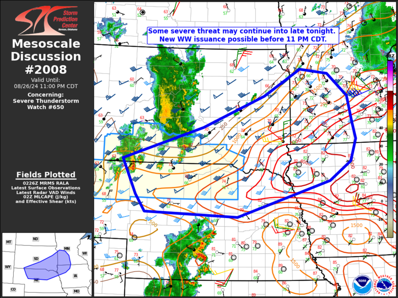
NWS Storm Prediction Center Norman OK
0928 PM CDT Mon Aug 26 2024
Areas affected...South-central/southeast SD...northern
NE...northwest IA...southwest MN
Concerning...Severe Thunderstorm Watch 650...
Valid 270228Z - 270400Z
The severe weather threat for Severe Thunderstorm Watch 650
continues.
SUMMARY...Some severe threat may continue into late tonight. New
watch issuance is possible prior to 11 PM CDT.
DISCUSSION...The northern portion of a long-lived QLCS has weakened
across central SD, within a relatively cool/stable environment. A
supercell has persisted along the southern flank of this system, and
produced occasional severe wind/hail reports. Evolution of this
system is uncertain with time, given that it has generally become
less organized, but will also eventually move into an increasingly
moist/unstable environment from northeast NE into southeast SD. Some
intensification may occur with this system later tonight, with
additional development possible farther southwest into
northwest/north-central NE, where stronger ascent will impinge upon
the region as a shortwave trough moves across the northern High
Plains. Late-night storm development will also be possible near the
deeper frontal zone and instability gradient from eastern SD into
southwest MN.
While details remain uncertain, moderate to strong buoyancy and
40-50 kt of effective shear will continue to support organized
convection into late tonight, with a threat of strong/severe gusts
and hail. New watch issuance is possible prior to 11 PM CDT in order
to address the late-night severe threat.
..Dean/Gleason.. 08/27/2024
...Please see www.spc.noaa.gov for graphic product...
ATTN...WFO...MPX...DMX...FSD...OAX...ABR...GID...LBF...UNR...
LAT...LON 43090232 43939951 44749737 45429608 45299512 44719443
44069427 43619416 43049436 42549509 41629831 41740151
42170184 43090232
|
|
Top/All Mesoscale Discussions/Forecast Products/Home
|
|


 @NWSSPC