 Note:
The expiration time in the watch graphic is amended if the watch is
replaced, cancelled or extended.
Note:
Note:
The expiration time in the watch graphic is amended if the watch is
replaced, cancelled or extended.
Note: Click for
Watch Status Reports.
SEL8
URGENT - IMMEDIATE BROADCAST REQUESTED
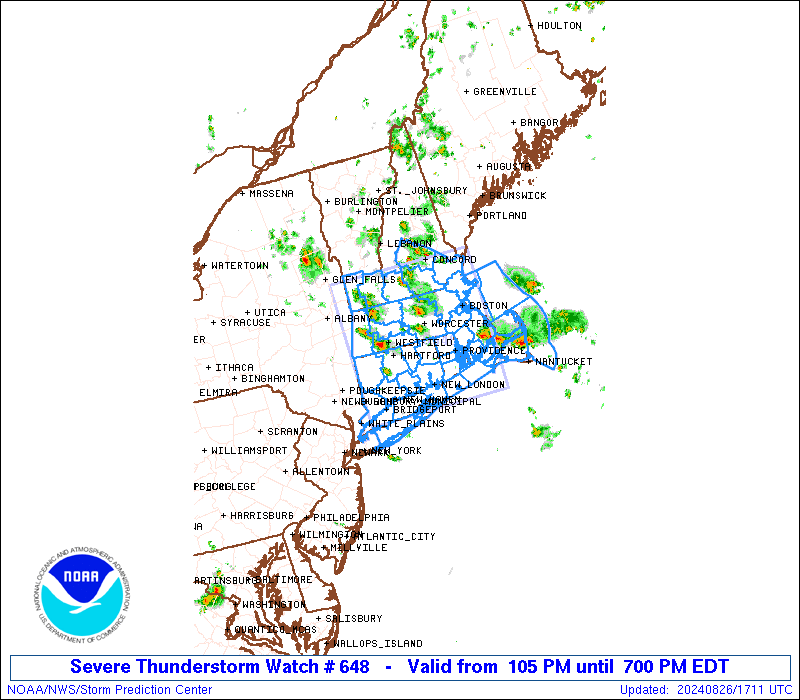
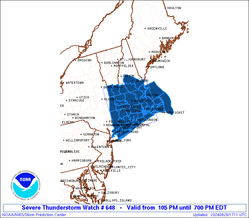
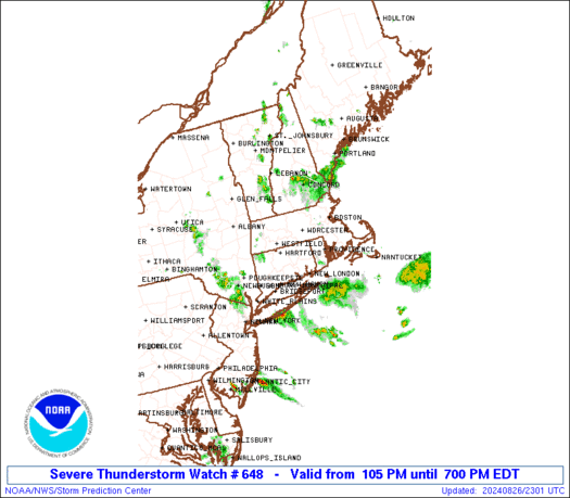
Severe Thunderstorm Watch Number 648
NWS Storm Prediction Center Norman OK
105 PM EDT Mon Aug 26 2024
The NWS Storm Prediction Center has issued a
* Severe Thunderstorm Watch for portions of
Connecticut
Massachusetts
Southern New Hampshire
Southeast New York
Rhode Island
Southern Vermont
Coastal Waters
* Effective this Monday afternoon and evening from 105 PM until
700 PM EDT.
* Primary threats include...
Scattered damaging wind gusts to 65 mph possible
Scattered large hail events to 1.5 inches in diameter possible
SUMMARY...Scattered thunderstorms will continue to develop and
intensify as they generally move south-southeastward through the
afternoon, with the strongest storms capable of hail and locally
damaging winds.
The severe thunderstorm watch area is approximately along and 75
statute miles east and west of a line from 25 miles north northeast
of Keene NH to 25 miles south of Groton CT. For a complete depiction
of the watch see the associated watch outline update (WOUS64 KWNS
WOU8).
PRECAUTIONARY/PREPAREDNESS ACTIONS...
REMEMBER...A Severe Thunderstorm Watch means conditions are
favorable for severe thunderstorms in and close to the watch area.
Persons in these areas should be on the lookout for threatening
weather conditions and listen for later statements and possible
warnings. Severe thunderstorms can and occasionally do produce
tornadoes.
&&
AVIATION...A few severe thunderstorms with hail surface and aloft to
1.5 inches. Extreme turbulence and surface wind gusts to 55 knots. A
few cumulonimbi with maximum tops to 500. Mean storm motion vector
35025.
...Guyer

   SEL8

   URGENT - IMMEDIATE BROADCAST REQUESTED
   Severe Thunderstorm Watch Number 648
   NWS Storm Prediction Center Norman OK
   105 PM EDT Mon Aug 26 2024

   The NWS Storm Prediction Center has issued a

   * Severe Thunderstorm Watch for portions of
     Connecticut
     Massachusetts
     Southern New Hampshire
     Southeast New York
     Rhode Island
     Southern Vermont
     Coastal Waters

   * Effective this Monday afternoon and evening from 105 PM until
     700 PM EDT.

   * Primary threats include...
     Scattered damaging wind gusts to 65 mph possible
     Scattered large hail events to 1.5 inches in diameter possible

   SUMMARY...Scattered thunderstorms will continue to develop and
   intensify as they generally move south-southeastward through the
   afternoon, with the strongest storms capable of hail and locally
   damaging winds.

   The severe thunderstorm watch area is approximately along and 75
   statute miles east and west of a line from 25 miles north northeast
   of Keene NH to 25 miles south of Groton CT. For a complete depiction
   of the watch see the associated watch outline update (WOUS64 KWNS
   WOU8).

   PRECAUTIONARY/PREPAREDNESS ACTIONS...

   REMEMBER...A Severe Thunderstorm Watch means conditions are
   favorable for severe thunderstorms in and close to the watch area.
   Persons in these areas should be on the lookout for threatening
   weather conditions and listen for later statements and possible
   warnings. Severe thunderstorms can and occasionally do produce
   tornadoes.

   &&

   AVIATION...A few severe thunderstorms with hail surface and aloft to
   1.5 inches. Extreme turbulence and surface wind gusts to 55 knots. A
   few cumulonimbi with maximum tops to 500. Mean storm motion vector
   35025.

   ...Guyer
 Note:
The Aviation Watch (SAW) product is an approximation to the watch area.
The actual watch is depicted by the shaded areas.
Note:
The Aviation Watch (SAW) product is an approximation to the watch area.
The actual watch is depicted by the shaded areas.
   SAW8
   WW 648 SEVERE TSTM CT MA NH NY RI VT CW 261705Z - 262300Z
   AXIS..75 STATUTE MILES EAST AND WEST OF LINE..
   25NNE EEN/KEENE NH/ - 25S GON/GROTON CT/
   ..AVIATION COORDS.. 65NM E/W /22W CON - 13ENE HTO/
   HAIL SURFACE AND ALOFT..1.5 INCHES. WIND GUSTS..55 KNOTS.
   MAX TOPS TO 500. MEAN STORM MOTION VECTOR 35025.

   LAT...LON 43227058 40967061 40967349 43227357

   THIS IS AN APPROXIMATION TO THE WATCH AREA.  FOR A
   COMPLETE DEPICTION OF THE WATCH SEE WOUS64 KWNS
   FOR WOU8.
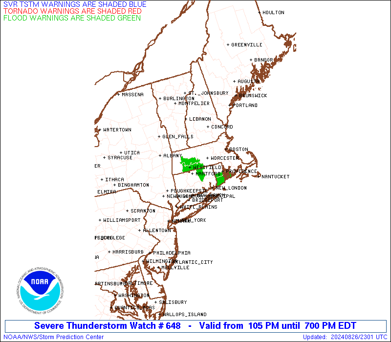
Watch 648 Status Report Messages:
STATUS REPORT #3 ON WW 648
VALID 262145Z - 262240Z
SEVERE WEATHER THREAT CONTINUES RIGHT OF A LINE FROM 15 ENE RUT
TO 5 SE EEN TO 80 ESE PSM.
..THORNTON..08/26/24
ATTN...WFO...OKX...BOX...ALY...GYX...
&&
STATUS REPORT FOR WS 648
SEVERE WEATHER THREAT CONTINUES FOR THE FOLLOWING AREAS
CTC001-003-005-007-009-011-013-015-262240-
CT
. CONNECTICUT COUNTIES INCLUDED ARE
FAIRFIELD HARTFORD LITCHFIELD
MIDDLESEX NEW HAVEN NEW LONDON
TOLLAND WINDHAM
$$
MAC001-003-005-007-009-011-013-015-017-019-021-023-025-027-
262240-
MA
. MASSACHUSETTS COUNTIES INCLUDED ARE
BARNSTABLE BERKSHIRE BRISTOL
DUKES ESSEX FRANKLIN
HAMPDEN HAMPSHIRE MIDDLESEX
NANTUCKET NORFOLK PLYMOUTH
SUFFOLK WORCESTER
$$
NHC005-262240-
NH
. NEW HAMPSHIRE COUNTIES INCLUDED ARE
CHESHIRE
$$
NYC103-262240-
NY
. NEW YORK COUNTIES INCLUDED ARE
SUFFOLK
$$
RIC001-003-005-007-009-262240-
RI
. RHODE ISLAND COUNTIES INCLUDED ARE
BRISTOL KENT NEWPORT
PROVIDENCE WASHINGTON
$$
VTC003-025-262240-
VT
. VERMONT COUNTIES INCLUDED ARE
BENNINGTON WINDHAM
$$
ANZ230-231-232-233-234-235-236-237-250-251-254-331-332-335-340-
345-262240-
CW
. ADJACENT COASTAL WATERS INCLUDED ARE
BOSTON HARBOR
CAPE COD BAY
NANTUCKET SOUND
VINEYARD SOUND
BUZZARDS BAY
RHODE ISLAND SOUND
NARRAGANSETT BAY
BLOCK ISLAND SOUND
COASTAL WATERS EAST OF IPSWICH BAY AND THE STELLWAGEN BANK
NATIONAL MARINE SANCTUARY
MASSACHUSETTS BAY AND IPSWICH BAY
COASTAL WATERS FROM PROVINCETOWN MA TO CHATHAM MA TO NANTUCKET MA
OUT 20 NM
LONG ISLAND SOUND EAST OF NEW HAVEN CT/PORT JEFFERSON NY TO THE
MOUTH OF THE CONNECTICUT RIVER
LONG ISLAND SOUND EAST OF THE MOUTH OF THE CONNECTICUT RIVER
LONG ISLAND SOUND WEST OF NEW HAVEN CT/PORT JEFFERSON NY
PECONIC AND GARDINERS BAYS
SOUTH SHORE BAYS FROM JONES INLET THROUGH SHINNECOCK BAY
$$
THE WATCH STATUS MESSAGE IS FOR GUIDANCE PURPOSES ONLY. PLEASE
REFER TO WATCH COUNTY NOTIFICATION STATEMENTS FOR OFFICIAL
INFORMATION ON COUNTIES...INDEPENDENT CITIES AND MARINE ZONES
CLEARED FROM SEVERE THUNDERSTORM AND TORNADO WATCHES.
$$
STATUS REPORT #2 ON WW 648
VALID 262015Z - 262140Z
SEVERE WEATHER THREAT CONTINUES RIGHT OF A LINE FROM 15 E RUT TO
5 SE EEN TO 80 ESE PSM.
..WENDT..08/26/24
ATTN...WFO...OKX...BOX...ALY...GYX...
&&
STATUS REPORT FOR WS 648
SEVERE WEATHER THREAT CONTINUES FOR THE FOLLOWING AREAS
CTC001-003-005-007-009-011-013-015-262140-
CT
. CONNECTICUT COUNTIES INCLUDED ARE
FAIRFIELD HARTFORD LITCHFIELD
MIDDLESEX NEW HAVEN NEW LONDON
TOLLAND WINDHAM
$$
MAC001-003-005-007-009-011-013-015-017-019-021-023-025-027-
262140-
MA
. MASSACHUSETTS COUNTIES INCLUDED ARE
BARNSTABLE BERKSHIRE BRISTOL
DUKES ESSEX FRANKLIN
HAMPDEN HAMPSHIRE MIDDLESEX
NANTUCKET NORFOLK PLYMOUTH
SUFFOLK WORCESTER
$$
NHC005-262140-
NH
. NEW HAMPSHIRE COUNTIES INCLUDED ARE
CHESHIRE
$$
NYC103-262140-
NY
. NEW YORK COUNTIES INCLUDED ARE
SUFFOLK
$$
RIC001-003-005-007-009-262140-
RI
. RHODE ISLAND COUNTIES INCLUDED ARE
BRISTOL KENT NEWPORT
PROVIDENCE WASHINGTON
$$
VTC003-025-262140-
VT
. VERMONT COUNTIES INCLUDED ARE
BENNINGTON WINDHAM
$$
ANZ230-231-232-233-234-235-236-237-250-251-254-331-332-335-340-
345-262140-
CW
. ADJACENT COASTAL WATERS INCLUDED ARE
BOSTON HARBOR
CAPE COD BAY
NANTUCKET SOUND
VINEYARD SOUND
BUZZARDS BAY
RHODE ISLAND SOUND
NARRAGANSETT BAY
BLOCK ISLAND SOUND
COASTAL WATERS EAST OF IPSWICH BAY AND THE STELLWAGEN BANK
NATIONAL MARINE SANCTUARY
MASSACHUSETTS BAY AND IPSWICH BAY
COASTAL WATERS FROM PROVINCETOWN MA TO CHATHAM MA TO NANTUCKET MA
OUT 20 NM
LONG ISLAND SOUND EAST OF NEW HAVEN CT/PORT JEFFERSON NY TO THE
MOUTH OF THE CONNECTICUT RIVER
LONG ISLAND SOUND EAST OF THE MOUTH OF THE CONNECTICUT RIVER
LONG ISLAND SOUND WEST OF NEW HAVEN CT/PORT JEFFERSON NY
PECONIC AND GARDINERS BAYS
SOUTH SHORE BAYS FROM JONES INLET THROUGH SHINNECOCK BAY
$$
THE WATCH STATUS MESSAGE IS FOR GUIDANCE PURPOSES ONLY. PLEASE
REFER TO WATCH COUNTY NOTIFICATION STATEMENTS FOR OFFICIAL
INFORMATION ON COUNTIES...INDEPENDENT CITIES AND MARINE ZONES
CLEARED FROM SEVERE THUNDERSTORM AND TORNADO WATCHES.
$$
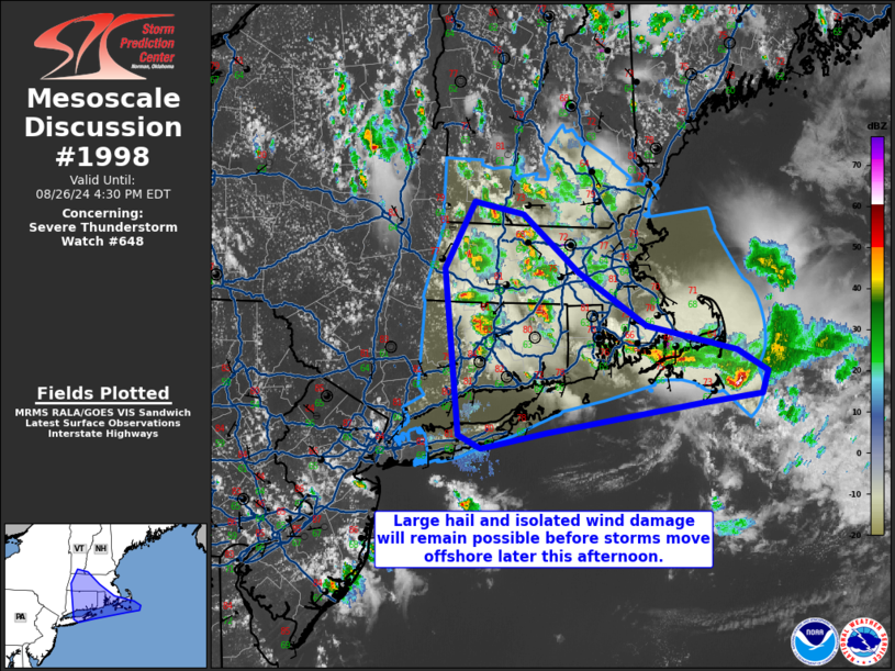
STATUS REPORT #1 ON WW 648
VALID 261830Z - 261940Z
THE SEVERE WEATHER THREAT CONTINUES ACROSS THE ENTIRE WATCH AREA.
FOR ADDITIONAL INFORMATION SEE MESOSCALE DISCUSSION 1998
..WENDT..08/26/24
ATTN...WFO...OKX...BOX...ALY...GYX...
&&
STATUS REPORT FOR WS 648
SEVERE WEATHER THREAT CONTINUES FOR THE FOLLOWING AREAS
CTC001-003-005-007-009-011-013-015-261940-
CT
. CONNECTICUT COUNTIES INCLUDED ARE
FAIRFIELD HARTFORD LITCHFIELD
MIDDLESEX NEW HAVEN NEW LONDON
TOLLAND WINDHAM
$$
MAC001-003-005-007-009-011-013-015-017-019-021-023-025-027-
261940-
MA
. MASSACHUSETTS COUNTIES INCLUDED ARE
BARNSTABLE BERKSHIRE BRISTOL
DUKES ESSEX FRANKLIN
HAMPDEN HAMPSHIRE MIDDLESEX
NANTUCKET NORFOLK PLYMOUTH
SUFFOLK WORCESTER
$$
NHC005-011-013-015-261940-
NH
. NEW HAMPSHIRE COUNTIES INCLUDED ARE
CHESHIRE HILLSBOROUGH MERRIMACK
ROCKINGHAM
$$
NYC103-261940-
NY
. NEW YORK COUNTIES INCLUDED ARE
SUFFOLK
$$
RIC001-003-005-007-009-261940-
RI
. RHODE ISLAND COUNTIES INCLUDED ARE
BRISTOL KENT NEWPORT
PROVIDENCE WASHINGTON
$$
VTC003-025-261940-
VT
. VERMONT COUNTIES INCLUDED ARE
BENNINGTON WINDHAM
$$
ANZ230-231-232-233-234-235-236-237-250-251-254-331-332-335-340-
345-261940-
CW
. ADJACENT COASTAL WATERS INCLUDED ARE
BOSTON HARBOR
CAPE COD BAY
NANTUCKET SOUND
VINEYARD SOUND
BUZZARDS BAY
RHODE ISLAND SOUND
NARRAGANSETT BAY
BLOCK ISLAND SOUND
COASTAL WATERS EAST OF IPSWICH BAY AND THE STELLWAGEN BANK
NATIONAL MARINE SANCTUARY
MASSACHUSETTS BAY AND IPSWICH BAY
COASTAL WATERS FROM PROVINCETOWN MA TO CHATHAM MA TO NANTUCKET MA
OUT 20 NM
LONG ISLAND SOUND EAST OF NEW HAVEN CT/PORT JEFFERSON NY TO THE
MOUTH OF THE CONNECTICUT RIVER
LONG ISLAND SOUND EAST OF THE MOUTH OF THE CONNECTICUT RIVER
LONG ISLAND SOUND WEST OF NEW HAVEN CT/PORT JEFFERSON NY
PECONIC AND GARDINERS BAYS
SOUTH SHORE BAYS FROM JONES INLET THROUGH SHINNECOCK BAY
$$
THE WATCH STATUS MESSAGE IS FOR GUIDANCE PURPOSES ONLY. PLEASE
REFER TO WATCH COUNTY NOTIFICATION STATEMENTS FOR OFFICIAL
INFORMATION ON COUNTIES...INDEPENDENT CITIES AND MARINE ZONES
CLEARED FROM SEVERE THUNDERSTORM AND TORNADO WATCHES.
$$
Note:
Click for Complete Product Text.
Tornadoes
Probability of 2 or more tornadoes
|
Low (<5%)
|
Probability of 1 or more strong (EF2-EF5) tornadoes
|
Low (<2%)
|
Wind
Probability of 10 or more severe wind events
|
Mod (50%)
|
Probability of 1 or more wind events > 65 knots
|
Low (10%)
|
Hail
Probability of 10 or more severe hail events
|
Mod (50%)
|
Probability of 1 or more hailstones > 2 inches
|
Low (10%)
|
Combined Severe Hail/Wind
Probability of 6 or more combined severe hail/wind events
|
High (80%)
|
For each watch, probabilities for particular events inside the watch
(listed above in each table) are determined by the issuing forecaster.
The "Low" category contains probability values ranging from less than 2%
to 20% (EF2-EF5 tornadoes), less than 5% to 20% (all other probabilities),
"Moderate" from 30% to 60%, and "High" from 70% to greater than 95%.
High values are bolded and lighter in color to provide awareness of
an increased threat for a particular event.


 @NWSSPC