 Note:
The expiration time in the watch graphic is amended if the watch is
replaced, cancelled or extended.
Note:
Note:
The expiration time in the watch graphic is amended if the watch is
replaced, cancelled or extended.
Note: Click for
Watch Status Reports.
SEL2
URGENT - IMMEDIATE BROADCAST REQUESTED
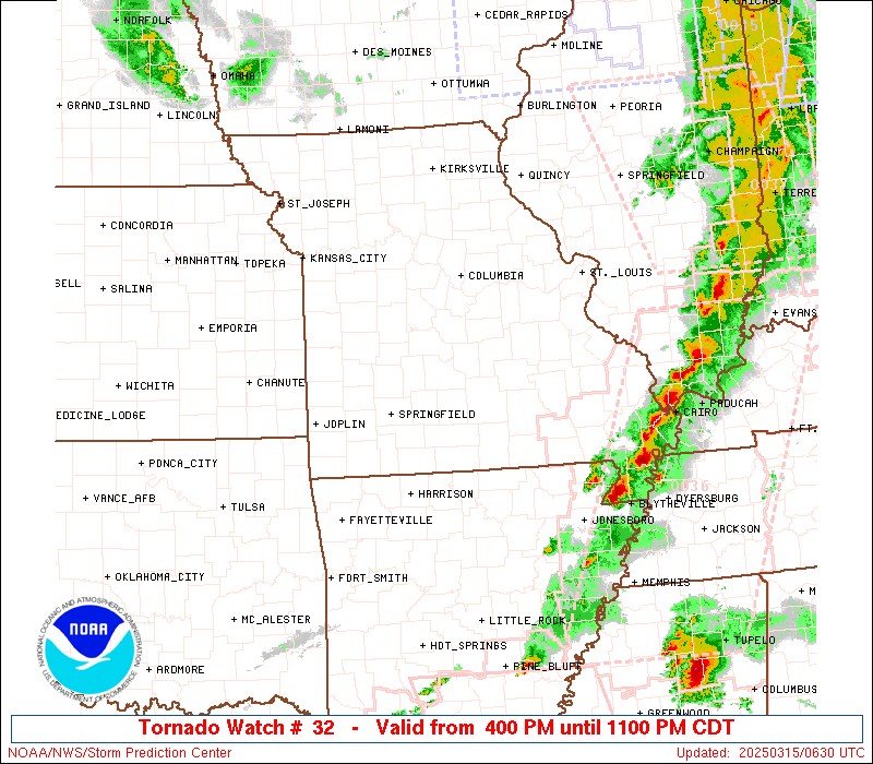
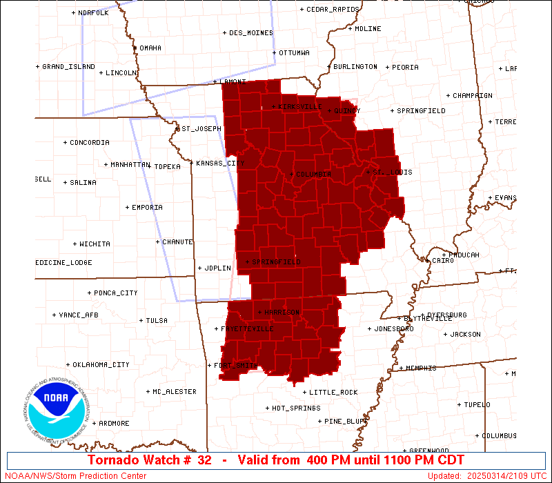
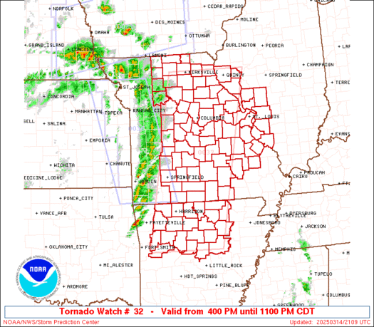
Tornado Watch Number 32
NWS Storm Prediction Center Norman OK
400 PM CDT Fri Mar 14 2025
The NWS Storm Prediction Center has issued a
* Tornado Watch for portions of
Northern Arkansas
Western Illinois
Central and Eastern Missouri
* Effective this Friday afternoon and evening from 400 PM until
1100 PM CDT.
* Primary threats include...
Several tornadoes and a couple intense tornadoes likely
Widespread damaging winds and isolated significant gusts to 90
mph likely
Scattered large hail and isolated very large hail events to 2.5
inches in diameter likely
SUMMARY...Intense thunderstorms will move very quickly
east-northeastward this afternoon and evening. Widespread
severe/damaging winds are the main threat this afternoon, with gusts
potentially reaching up to 80-90 mph. The tornado and large hail
threat is expected to increase later this evening, with sustained
supercells potentially posing a threat for multiple strong tornadoes
as moisture returns northward across Arkansas into Missouri and
Illinois.
The tornado watch area is approximately along and 70 statute miles
east and west of a line from 35 miles west northwest of Quincy IL to
15 miles east southeast of Russellville AR. For a complete depiction
of the watch see the associated watch outline update (WOUS64 KWNS
WOU2).
PRECAUTIONARY/PREPAREDNESS ACTIONS...
REMEMBER...A Tornado Watch means conditions are favorable for
tornadoes and severe thunderstorms in and close to the watch
area. Persons in these areas should be on the lookout for
threatening weather conditions and listen for later statements
and possible warnings.
&&
OTHER WATCH INFORMATION...CONTINUE...WW 30...WW 31...
AVIATION...Tornadoes and a few severe thunderstorms with hail
surface and aloft to 2.5 inches. Extreme turbulence and surface wind
gusts to 80 knots. A few cumulonimbi with maximum tops to 500. Mean
storm motion vector 22055.
...Gleason

   SEL2

   URGENT - IMMEDIATE BROADCAST REQUESTED
   Tornado Watch Number 32
   NWS Storm Prediction Center Norman OK
   400 PM CDT Fri Mar 14 2025

   The NWS Storm Prediction Center has issued a

   * Tornado Watch for portions of
     Northern Arkansas
     Western Illinois
     Central and Eastern Missouri

   * Effective this Friday afternoon and evening from 400 PM until
     1100 PM CDT.

   * Primary threats include...
     Several tornadoes and a couple intense tornadoes likely
     Widespread damaging winds and isolated significant gusts to 90
       mph likely
     Scattered large hail and isolated very large hail events to 2.5
       inches in diameter likely

   SUMMARY...Intense thunderstorms will move very quickly
   east-northeastward this afternoon and evening. Widespread
   severe/damaging winds are the main threat this afternoon, with gusts
   potentially reaching up to 80-90 mph. The tornado and large hail
   threat is expected to increase later this evening, with sustained
   supercells potentially posing a threat for multiple strong tornadoes
   as moisture returns northward across Arkansas into Missouri and
   Illinois.

   The tornado watch area is approximately along and 70 statute miles
   east and west of a line from 35 miles west northwest of Quincy IL to
   15 miles east southeast of Russellville AR. For a complete depiction
   of the watch see the associated watch outline update (WOUS64 KWNS
   WOU2).

   PRECAUTIONARY/PREPAREDNESS ACTIONS...

   REMEMBER...A Tornado Watch means conditions are favorable for
   tornadoes and severe thunderstorms in and close to the watch
   area. Persons in these areas should be on the lookout for
   threatening weather conditions and listen for later statements
   and possible warnings.

   &&

   OTHER WATCH INFORMATION...CONTINUE...WW 30...WW 31...

   AVIATION...Tornadoes and a few severe thunderstorms with hail
   surface and aloft to 2.5 inches. Extreme turbulence and surface wind
   gusts to 80 knots. A few cumulonimbi with maximum tops to 500. Mean
   storm motion vector 22055.

   ...Gleason
 Note:
The Aviation Watch (SAW) product is an approximation to the watch area.
The actual watch is depicted by the shaded areas.
Note:
The Aviation Watch (SAW) product is an approximation to the watch area.
The actual watch is depicted by the shaded areas.
   SAW2
   WW 32 TORNADO AR IL MO 142100Z - 150400Z
   AXIS..70 STATUTE MILES EAST AND WEST OF LINE..
   35WNW UIN/QUINCY IL/ - 15ESE RUE/RUSSELLVILLE AR/
   ..AVIATION COORDS.. 60NM E/W /30NW UIN - 44NW LIT/
   HAIL SURFACE AND ALOFT..2.5 INCHES. WIND GUSTS..80 KNOTS.
   MAX TOPS TO 500. MEAN STORM MOTION VECTOR 22055.

   LAT...LON 40139049 35169161 35169408 40139314

   THIS IS AN APPROXIMATION TO THE WATCH AREA.  FOR A
   COMPLETE DEPICTION OF THE WATCH SEE WOUS64 KWNS
   FOR WOU2.
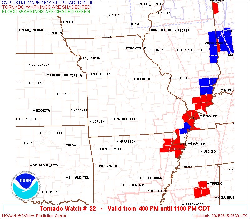
Watch 32 Status Report Messages:
STATUS REPORT #2 ON WW 32
VALID 150240Z - 150340Z
SEVERE WEATHER THREAT CONTINUES RIGHT OF A LINE FROM 15 W HOT TO
10 ESE FLP TO 25 WNW UNO TO 15 SSW VIH TO 35 WNW STL TO 35 SE UIN
TO 30 SSW BRL.
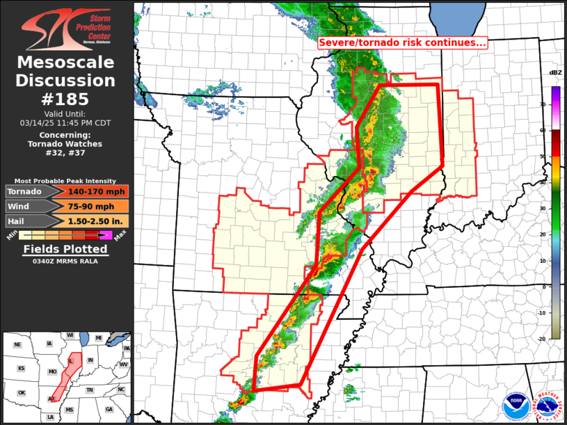
FOR ADDITIONAL INFORMATION SEE MESOSCALE DISCUSSION 181
..MOORE..03/15/25
ATTN...WFO...LZK...TSA...LSX...EAX...SGF...
&&
STATUS REPORT FOR WT 32
SEVERE WEATHER THREAT CONTINUES FOR THE FOLLOWING AREAS
ARC005-023-029-045-049-063-065-067-075-085-095-105-117-119-121-
125-135-137-141-145-147-150340-
AR
. ARKANSAS COUNTIES INCLUDED ARE
BAXTER CLEBURNE CONWAY
FAULKNER FULTON INDEPENDENCE
IZARD JACKSON LAWRENCE
LONOKE MONROE PERRY
PRAIRIE PULASKI RANDOLPH
SALINE SHARP STONE
VAN BUREN WHITE WOODRUFF
$$
ILC009-013-061-083-117-119-133-157-163-150340-
IL
. ILLINOIS COUNTIES INCLUDED ARE
BROWN CALHOUN GREENE
JERSEY MACOUPIN MADISON
MONROE RANDOLPH ST. CLAIR
$$
MOC055-065-071-091-093-099-123-149-161-179-183-186-187-189-203-
215-221-510-150340-
MO
. MISSOURI COUNTIES INCLUDED ARE
CRAWFORD DENT FRANKLIN
HOWELL IRON JEFFERSON
MADISON OREGON PHELPS
REYNOLDS ST. CHARLES STE. GENEVIEVE
ST. FRANCOIS ST. LOUIS SHANNON
TEXAS WASHINGTON
MISSOURI INDEPENDENT CITIES INCLUDED ARE
ST. LOUIS CITY
$$
THE WATCH STATUS MESSAGE IS FOR GUIDANCE PURPOSES ONLY. PLEASE
REFER TO WATCH COUNTY NOTIFICATION STATEMENTS FOR OFFICIAL
INFORMATION ON COUNTIES...INDEPENDENT CITIES AND MARINE ZONES
CLEARED FROM SEVERE THUNDERSTORM AND TORNADO WATCHES.
$$
STATUS REPORT #1 ON WW 32
VALID 142250Z - 142340Z
THE SEVERE WEATHER THREAT CONTINUES ACROSS THE ENTIRE WATCH AREA.
..LYONS..03/14/25
ATTN...WFO...LZK...TSA...LSX...EAX...SGF...
&&
STATUS REPORT FOR WT 32
SEVERE WEATHER THREAT CONTINUES FOR THE FOLLOWING AREAS
ARC005-009-015-023-029-045-047-049-063-065-071-083-087-089-101-
115-129-135-137-141-145-142340-
AR
. ARKANSAS COUNTIES INCLUDED ARE
BAXTER BOONE CARROLL
CLEBURNE CONWAY FAULKNER
FRANKLIN FULTON INDEPENDENCE
IZARD JOHNSON LOGAN
MADISON MARION NEWTON
POPE SEARCY SHARP
STONE VAN BUREN WHITE
$$
ILC001-009-013-061-083-117-119-133-149-157-163-142340-
IL
. ILLINOIS COUNTIES INCLUDED ARE
ADAMS BROWN CALHOUN
GREENE JERSEY MACOUPIN
MADISON MONROE PIKE
RANDOLPH ST. CLAIR
$$
MOC001-007-015-019-027-029-033-041-043-051-053-055-059-065-067-
071-073-077-079-085-089-091-093-099-103-105-111-113-115-117-121-
123-125-127-129-131-135-137-139-141-149-151-153-159-161-163-167-
169-171-173-175-179-183-186-187-189-195-197-203-205-211-213-215-
219-221-225-229-510-142340-
MO
. MISSOURI COUNTIES INCLUDED ARE
ADAIR AUDRAIN BENTON
BOONE CALLAWAY CAMDEN
CARROLL CHARITON CHRISTIAN
COLE COOPER CRAWFORD
DALLAS DENT DOUGLAS
FRANKLIN GASCONADE GREENE
GRUNDY HICKORY HOWARD
HOWELL IRON JEFFERSON
KNOX LACLEDE LEWIS
LINCOLN LINN LIVINGSTON
MACON MADISON MARIES
MARION MERCER MILLER
MONITEAU MONROE MONTGOMERY
MORGAN OREGON OSAGE
OZARK PETTIS PHELPS
PIKE POLK PULASKI
PUTNAM RALLS RANDOLPH
REYNOLDS ST. CHARLES STE. GENEVIEVE
ST. FRANCOIS ST. LOUIS SALINE
SCHUYLER SHANNON SHELBY
SULLIVAN TANEY TEXAS
WARREN WASHINGTON WEBSTER
WRIGHT
MISSOURI INDEPENDENT CITIES INCLUDED ARE
ST. LOUIS CITY
$$
THE WATCH STATUS MESSAGE IS FOR GUIDANCE PURPOSES ONLY. PLEASE
REFER TO WATCH COUNTY NOTIFICATION STATEMENTS FOR OFFICIAL
INFORMATION ON COUNTIES...INDEPENDENT CITIES AND MARINE ZONES
CLEARED FROM SEVERE THUNDERSTORM AND TORNADO WATCHES.
$$
Note:
Click for Complete Product Text.
Tornadoes
Probability of 2 or more tornadoes
|
High (90%)
|
Probability of 1 or more strong (EF2-EF5) tornadoes
|
High (70%)
|
Wind
Probability of 10 or more severe wind events
|
High (90%)
|
Probability of 1 or more wind events > 65 knots
|
High (70%)
|
Hail
Probability of 10 or more severe hail events
|
High (70%)
|
Probability of 1 or more hailstones > 2 inches
|
Mod (60%)
|
Combined Severe Hail/Wind
Probability of 6 or more combined severe hail/wind events
|
High (>95%)
|
For each watch, probabilities for particular events inside the watch
(listed above in each table) are determined by the issuing forecaster.
The "Low" category contains probability values ranging from less than 2%
to 20% (EF2-EF5 tornadoes), less than 5% to 20% (all other probabilities),
"Moderate" from 30% to 60%, and "High" from 70% to greater than 95%.
High values are bolded and lighter in color to provide awareness of
an increased threat for a particular event.


 @NWSSPC