Note:
The expiration time in the watch graphic is amended if the watch is
replaced, cancelled or extended.
Note:
Note:
The expiration time in the watch graphic is amended if the watch is
replaced, cancelled or extended.
Note: Click for
Watch Status Reports.
SEL1
URGENT - IMMEDIATE BROADCAST REQUESTED
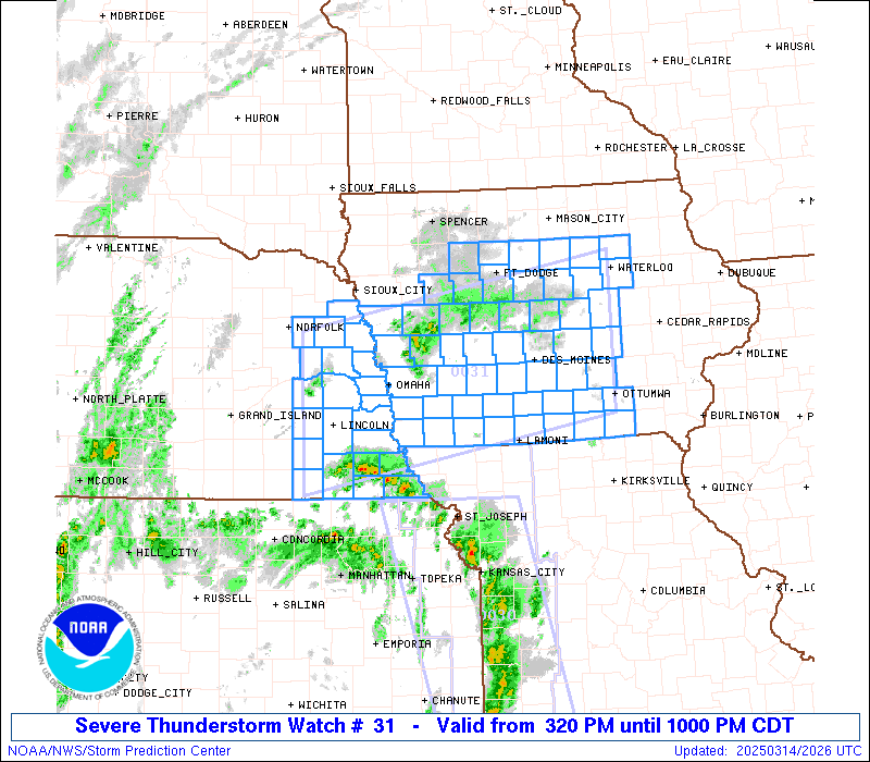
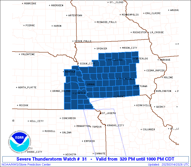
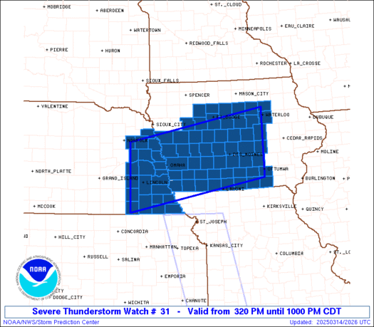
Severe Thunderstorm Watch Number 31
NWS Storm Prediction Center Norman OK
320 PM CDT Fri Mar 14 2025
The NWS Storm Prediction Center has issued a
* Severe Thunderstorm Watch for portions of
Western and Central Iowa
Eastern Nebraska
* Effective this Friday afternoon and evening from 320 PM until
1000 PM CDT.
* Primary threats include...
Widespread damaging winds and isolated significant gusts to 90
mph likely
Scattered large hail events to 1.5 inches in diameter possible
A tornado or two possible
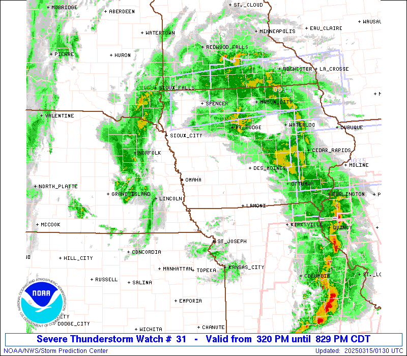
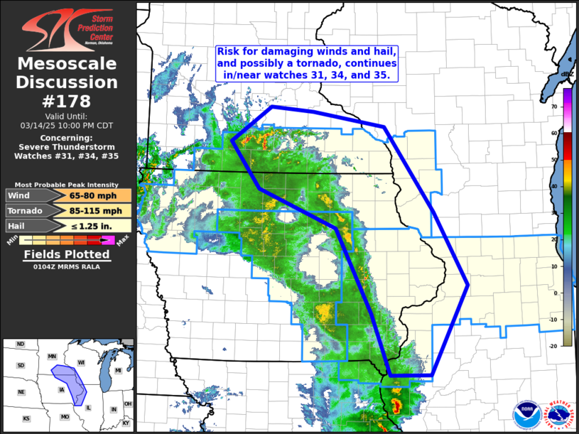
SUMMARY...Thunderstorms will spread rapidly north-northeastward this
afternoon and evening, while posing a threat for widespread
severe/damaging winds. The strongest wind gusts could reach 80-90
mph on an isolated basis. Some hail and perhaps a tornado could also
occur if a supercell can form and be sustained later this evening.
The severe thunderstorm watch area is approximately along and 65
statute miles north and south of a line from 25 miles west northwest
of Lincoln NE to 50 miles north of Ottumwa IA. For a complete
depiction of the watch see the associated watch outline update
(WOUS64 KWNS WOU1).
PRECAUTIONARY/PREPAREDNESS ACTIONS...
REMEMBER...A Severe Thunderstorm Watch means conditions are
favorable for severe thunderstorms in and close to the watch area.
Persons in these areas should be on the lookout for threatening
weather conditions and listen for later statements and possible
warnings. Severe thunderstorms can and occasionally do produce
tornadoes.
&&
OTHER WATCH INFORMATION...CONTINUE...WW 30...
AVIATION...A few severe thunderstorms with hail surface and aloft to
1.5 inches. Extreme turbulence and surface wind gusts to 80 knots. A
few cumulonimbi with maximum tops to 500. Mean storm motion vector
19055.
...Gleason

   SEL1

   URGENT - IMMEDIATE BROADCAST REQUESTED
   Severe Thunderstorm Watch Number 31
   NWS Storm Prediction Center Norman OK
   320 PM CDT Fri Mar 14 2025

   The NWS Storm Prediction Center has issued a

   * Severe Thunderstorm Watch for portions of
     Western and Central Iowa
     Eastern Nebraska

   * Effective this Friday afternoon and evening from 320 PM until
     1000 PM CDT.

   * Primary threats include...
     Widespread damaging winds and isolated significant gusts to 90
       mph likely
     Scattered large hail events to 1.5 inches in diameter possible
     A tornado or two possible

   SUMMARY...Thunderstorms will spread rapidly north-northeastward this
   afternoon and evening, while posing a threat for widespread
   severe/damaging winds. The strongest wind gusts could reach 80-90
   mph on an isolated basis. Some hail and perhaps a tornado could also
   occur if a supercell can form and be sustained later this evening.

   The severe thunderstorm watch area is approximately along and 65
   statute miles north and south of a line from 25 miles west northwest
   of Lincoln NE to 50 miles north of Ottumwa IA. For a complete
   depiction of the watch see the associated watch outline update
   (WOUS64 KWNS WOU1).

   PRECAUTIONARY/PREPAREDNESS ACTIONS...

   REMEMBER...A Severe Thunderstorm Watch means conditions are
   favorable for severe thunderstorms in and close to the watch area.
   Persons in these areas should be on the lookout for threatening
   weather conditions and listen for later statements and possible
   warnings. Severe thunderstorms can and occasionally do produce
   tornadoes.

   &&

   OTHER WATCH INFORMATION...CONTINUE...WW 30...

   AVIATION...A few severe thunderstorms with hail surface and aloft to
   1.5 inches. Extreme turbulence and surface wind gusts to 80 knots. A
   few cumulonimbi with maximum tops to 500. Mean storm motion vector
   19055.

   ...Gleason
 Note:
The Aviation Watch (SAW) product is an approximation to the watch area.
The actual watch is depicted by the shaded areas.
Note:
The Aviation Watch (SAW) product is an approximation to the watch area.
The actual watch is depicted by the shaded areas.
   SAW1
   WW 31 SEVERE TSTM IA NE 142020Z - 150300Z
   AXIS..65 STATUTE MILES NORTH AND SOUTH OF LINE..
   25WNW LNK/LINCOLN NE/ - 50N OTM/OTTUMWA IA/
   ..AVIATION COORDS.. 55NM N/S /57ESE OBH - 42WNW IOW/
   HAIL SURFACE AND ALOFT..1.5 INCHES. WIND GUSTS..80 KNOTS.
   MAX TOPS TO 500. MEAN STORM MOTION VECTOR 19055.

   LAT...LON 41939721 42769245 40889245 40059721

   THIS IS AN APPROXIMATION TO THE WATCH AREA.  FOR A
   COMPLETE DEPICTION OF THE WATCH SEE WOUS64 KWNS
   FOR WOU1.
Watch 31 Status Report Messages:
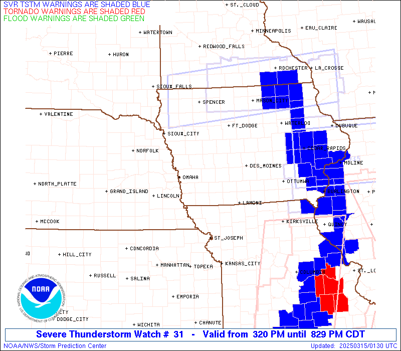
STATUS REPORT #4 ON WW 31

VALID 150130Z - 150240Z

SEVERE WEATHER THREAT CONTINUES RIGHT OF A LINE FROM 5 NNE OTM TO
30 NE OXV TO 45 NNE DSM TO 15 E FOD.

..GOSS..03/15/25

ATTN...WFO...DMX...OAX...

&&

STATUS REPORT FOR WS 31

SEVERE WEATHER THREAT CONTINUES FOR THE FOLLOWING AREAS

IAC007-013-017-023-069-075-079-083-091-099-123-127-157-169-171-
179-197-150240-

IA
.    IOWA COUNTIES INCLUDED ARE

APPANOOSE	     BLACK HAWK 	 BREMER
BUTLER		     FRANKLIN		 GRUNDY
HAMILTON	     HARDIN		 HUMBOLDT
JASPER		     MAHASKA		 MARSHALL
POWESHIEK	     STORY		 TAMA
WAPELLO 	     WRIGHT
$$


THE WATCH STATUS MESSAGE IS FOR GUIDANCE PURPOSES ONLY.  PLEASE
REFER TO WATCH COUNTY NOTIFICATION STATEMENTS FOR OFFICIAL
INFORMATION ON COUNTIES...INDEPENDENT CITIES AND MARINE ZONES
CLEARED FROM SEVERE THUNDERSTORM AND TORNADO WATCHES.
$$

STATUS REPORT #3 ON WW 31

VALID 150125Z - 150240Z

SEVERE WEATHER THREAT CONTINUES RIGHT OF A LINE FROM 15 NNE OTM
TO 40 NE OXV TO 40 WSW ALO TO 25 ENE FOD.

..GOSS..03/15/25

ATTN...WFO...DMX...OAX...

&&

STATUS REPORT FOR WS 31

SEVERE WEATHER THREAT CONTINUES FOR THE FOLLOWING AREAS

IAC007-013-015-017-023-051-069-075-079-083-091-099-123-125-127-
135-151-153-157-169-171-179-187-197-150240-

IA
.    IOWA COUNTIES INCLUDED ARE

APPANOOSE	     BLACK HAWK 	 BOONE
BREMER		     BUTLER		 DAVIS
FRANKLIN	     GRUNDY		 HAMILTON
HARDIN		     HUMBOLDT		 JASPER
MAHASKA 	     MARION		 MARSHALL
MONROE		     POCAHONTAS 	 POLK
POWESHIEK	     STORY		 TAMA
WAPELLO 	     WEBSTER		 WRIGHT
$$


THE WATCH STATUS MESSAGE IS FOR GUIDANCE PURPOSES ONLY.  PLEASE
REFER TO WATCH COUNTY NOTIFICATION STATEMENTS FOR OFFICIAL
INFORMATION ON COUNTIES...INDEPENDENT CITIES AND MARINE ZONES
CLEARED FROM SEVERE THUNDERSTORM AND TORNADO WATCHES.
$$

STATUS REPORT #2 ON WW 31

VALID 142250Z - 142340Z

SEVERE WEATHER THREAT CONTINUES RIGHT OF A LINE FROM 10 SW LWD TO
25 E SDA TO 15 S OMA TO 25 S OLU.

..LYONS..03/14/25

ATTN...WFO...DMX...OAX...

&&

STATUS REPORT FOR WS 31

SEVERE WEATHER THREAT CONTINUES FOR THE FOLLOWING AREAS

IAC001-003-007-009-013-015-017-023-025-027-029-039-047-049-051-
053-069-073-075-077-079-083-085-091-099-117-121-123-125-127-133-
135-151-153-155-157-159-161-165-169-171-173-175-179-181-185-187-
197-142340-

IA
.    IOWA COUNTIES INCLUDED ARE

ADAIR		     ADAMS		 APPANOOSE
AUDUBON 	     BLACK HAWK 	 BOONE
BREMER		     BUTLER		 CALHOUN
CARROLL 	     CASS		 CLARKE
CRAWFORD	     DALLAS		 DAVIS
DECATUR 	     FRANKLIN		 GREENE
GRUNDY		     GUTHRIE		 HAMILTON
HARDIN		     HARRISON		 HUMBOLDT
JASPER		     LUCAS		 MADISON
MAHASKA 	     MARION		 MARSHALL
MONONA		     MONROE		 POCAHONTAS
POLK		     POTTAWATTAMIE	 POWESHIEK
RINGGOLD	     SAC		 SHELBY
STORY		     TAMA		 TAYLOR
UNION		     WAPELLO		 WARREN
WAYNE		     WEBSTER		 WRIGHT
$$


NEC021-023-037-039-053-055-155-167-173-177-142340-

NE
.    NEBRASKA COUNTIES INCLUDED ARE

BURT		     BUTLER		 COLFAX
CUMING		     DODGE		 DOUGLAS
SAUNDERS	     STANTON		 THURSTON
WASHINGTON
$$


THE WATCH STATUS MESSAGE IS FOR GUIDANCE PURPOSES ONLY.  PLEASE
REFER TO WATCH COUNTY NOTIFICATION STATEMENTS FOR OFFICIAL
INFORMATION ON COUNTIES...INDEPENDENT CITIES AND MARINE ZONES
CLEARED FROM SEVERE THUNDERSTORM AND TORNADO WATCHES.
$$

STATUS REPORT #1 ON WW 31

VALID 142150Z - 142240Z

SEVERE WEATHER THREAT CONTINUES RIGHT OF A LINE FROM 20 NE FNB TO
20 SSE LNK TO 45 E HSI.

..LYONS..03/14/25

ATTN...WFO...DMX...OAX...

&&

STATUS REPORT FOR WS 31

SEVERE WEATHER THREAT CONTINUES FOR THE FOLLOWING AREAS

IAC001-003-007-009-013-015-017-023-025-027-029-039-047-049-051-
053-069-071-073-075-077-079-083-085-091-099-117-121-123-125-127-
129-133-135-137-145-151-153-155-157-159-161-165-169-171-173-175-
179-181-185-187-197-142240-

IA
.    IOWA COUNTIES INCLUDED ARE

ADAIR		     ADAMS		 APPANOOSE
AUDUBON 	     BLACK HAWK 	 BOONE
BREMER		     BUTLER		 CALHOUN
CARROLL 	     CASS		 CLARKE
CRAWFORD	     DALLAS		 DAVIS
DECATUR 	     FRANKLIN		 FREMONT
GREENE		     GRUNDY		 GUTHRIE
HAMILTON	     HARDIN		 HARRISON
HUMBOLDT	     JASPER		 LUCAS
MADISON 	     MAHASKA		 MARION
MARSHALL	     MILLS		 MONONA
MONROE		     MONTGOMERY 	 PAGE
POCAHONTAS	     POLK		 POTTAWATTAMIE
POWESHIEK	     RINGGOLD		 SAC
SHELBY		     STORY		 TAMA
TAYLOR		     UNION		 WAPELLO
WARREN		     WAYNE		 WEBSTER
WRIGHT
$$


NEC021-023-025-037-039-053-055-109-131-153-155-159-167-173-177-
142240-

NE
.    NEBRASKA COUNTIES INCLUDED ARE

BURT		     BUTLER		 CASS
COLFAX		     CUMING		 DODGE
DOUGLAS 	     LANCASTER		 OTOE
SARPY		     SAUNDERS		 SEWARD
STANTON 	     THURSTON		 WASHINGTON
$$


THE WATCH STATUS MESSAGE IS FOR GUIDANCE PURPOSES ONLY.  PLEASE
REFER TO WATCH COUNTY NOTIFICATION STATEMENTS FOR OFFICIAL
INFORMATION ON COUNTIES...INDEPENDENT CITIES AND MARINE ZONES
CLEARED FROM SEVERE THUNDERSTORM AND TORNADO WATCHES.
$$
Note:
Click for Complete Product Text.
Tornadoes
Probability of 2 or more tornadoes
|
Low (20%)
|
Probability of 1 or more strong (EF2-EF5) tornadoes
|
Low (10%)
|
Wind
Probability of 10 or more severe wind events
|
High (90%)
|
Probability of 1 or more wind events > 65 knots
|
High (70%)
|
Hail
Probability of 10 or more severe hail events
|
Mod (40%)
|
Probability of 1 or more hailstones > 2 inches
|
Low (20%)
|
Combined Severe Hail/Wind
Probability of 6 or more combined severe hail/wind events
|
High (>95%)
|
For each watch, probabilities for particular events inside the watch
(listed above in each table) are determined by the issuing forecaster.
The "Low" category contains probability values ranging from less than 2%
to 20% (EF2-EF5 tornadoes), less than 5% to 20% (all other probabilities),
"Moderate" from 30% to 60%, and "High" from 70% to greater than 95%.
High values are bolded and lighter in color to provide awareness of
an increased threat for a particular event.


 @NWSSPC