 Note:
The expiration time in the watch graphic is amended if the watch is
replaced, cancelled or extended.
Note:
Note:
The expiration time in the watch graphic is amended if the watch is
replaced, cancelled or extended.
Note: Click for
Watch Status Reports.
SEL0
URGENT - IMMEDIATE BROADCAST REQUESTED
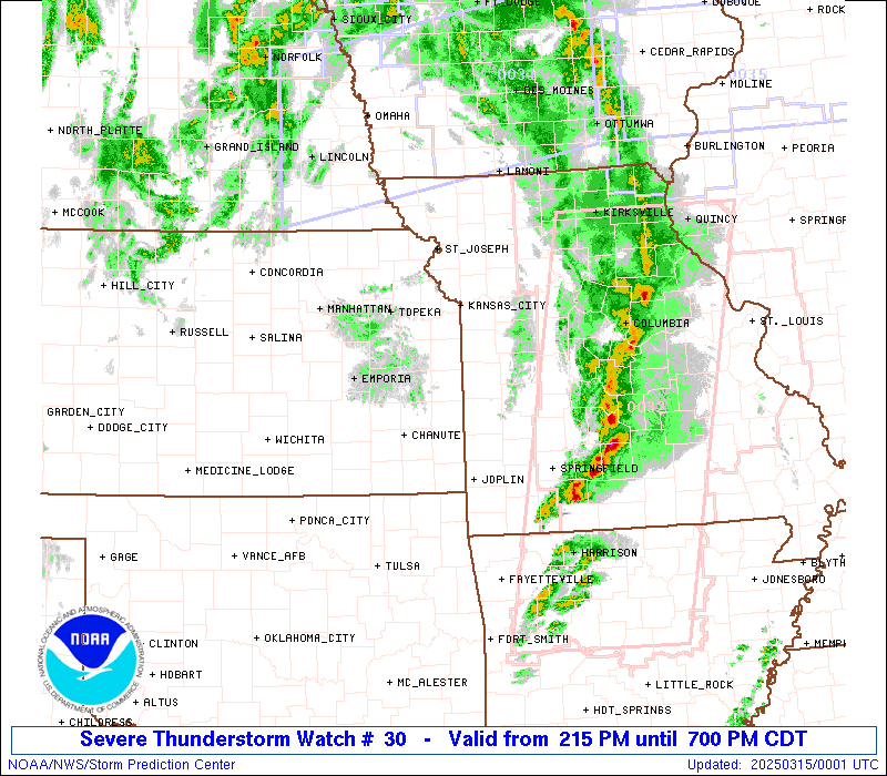
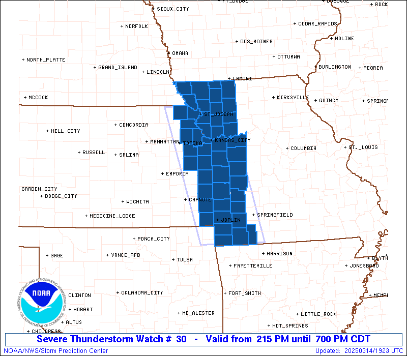
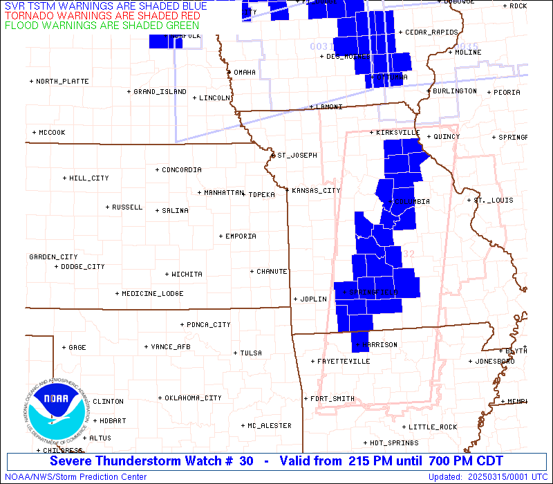
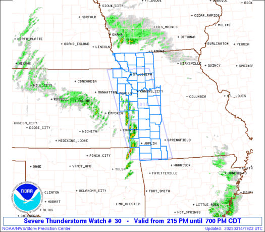
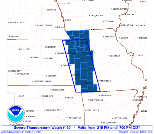
Severe Thunderstorm Watch Number 30
NWS Storm Prediction Center Norman OK
215 PM CDT Fri Mar 14 2025
The NWS Storm Prediction Center has issued a
* Severe Thunderstorm Watch for portions of
Eastern Kansas
Western Missouri
* Effective this Friday afternoon and evening from 215 PM until
700 PM CDT.
* Primary threats include...
Widespread damaging winds and isolated significant gusts to 80
mph likely
Scattered large hail and isolated very large hail events to 2
inches in diameter possible
A tornado or two possible
SUMMARY...Thunderstorms will rapidly develop and move
north-northeastward across eastern Kansas into western Missouri this
afternoon. Widespread severe/damaging winds appear likely with this
initial activity, along with some hail if supercells can become
established. The tornado threat should remain fairly low for the
next couple of hours, but a tornado or two may occur later with
eastward extent towards central Missouri.
The severe thunderstorm watch area is approximately along and 55
statute miles east and west of a line from 15 miles north northwest
of Saint Joseph MO to 25 miles south southwest of Monett MO. For a
complete depiction of the watch see the associated watch outline
update (WOUS64 KWNS WOU0).
PRECAUTIONARY/PREPAREDNESS ACTIONS...
REMEMBER...A Severe Thunderstorm Watch means conditions are
favorable for severe thunderstorms in and close to the watch area.
Persons in these areas should be on the lookout for threatening
weather conditions and listen for later statements and possible
warnings. Severe thunderstorms can and occasionally do produce
tornadoes.
&&
AVIATION...A few severe thunderstorms with hail surface and aloft to
2 inches. Extreme turbulence and surface wind gusts to 70 knots. A
few cumulonimbi with maximum tops to 500. Mean storm motion vector
22055.
...Gleason

   SEL0

   URGENT - IMMEDIATE BROADCAST REQUESTED
   Severe Thunderstorm Watch Number 30
   NWS Storm Prediction Center Norman OK
   215 PM CDT Fri Mar 14 2025

   The NWS Storm Prediction Center has issued a

   * Severe Thunderstorm Watch for portions of
     Eastern Kansas
     Western Missouri

   * Effective this Friday afternoon and evening from 215 PM until
     700 PM CDT.

   * Primary threats include...
     Widespread damaging winds and isolated significant gusts to 80
       mph likely
     Scattered large hail and isolated very large hail events to 2
       inches in diameter possible
     A tornado or two possible

   SUMMARY...Thunderstorms will rapidly develop and move
   north-northeastward across eastern Kansas into western Missouri this
   afternoon. Widespread severe/damaging winds appear likely with this
   initial activity, along with some hail if supercells can become
   established. The tornado threat should remain fairly low for the
   next couple of hours, but a tornado or two may occur later with
   eastward extent towards central Missouri.

   The severe thunderstorm watch area is approximately along and 55
   statute miles east and west of a line from 15 miles north northwest
   of Saint Joseph MO to 25 miles south southwest of Monett MO. For a
   complete depiction of the watch see the associated watch outline
   update (WOUS64 KWNS WOU0).

   PRECAUTIONARY/PREPAREDNESS ACTIONS...

   REMEMBER...A Severe Thunderstorm Watch means conditions are
   favorable for severe thunderstorms in and close to the watch area.
   Persons in these areas should be on the lookout for threatening
   weather conditions and listen for later statements and possible
   warnings. Severe thunderstorms can and occasionally do produce
   tornadoes.

   &&

   AVIATION...A few severe thunderstorms with hail surface and aloft to
   2 inches. Extreme turbulence and surface wind gusts to 70 knots. A
   few cumulonimbi with maximum tops to 500. Mean storm motion vector
   22055.

   ...Gleason
 Note:
The Aviation Watch (SAW) product is an approximation to the watch area.
The actual watch is depicted by the shaded areas.
Note:
The Aviation Watch (SAW) product is an approximation to the watch area.
The actual watch is depicted by the shaded areas.
   SAW0
   WW 30 SEVERE TSTM KS MO 141915Z - 150000Z
   AXIS..55 STATUTE MILES EAST AND WEST OF LINE..
   15NNW STJ/SAINT JOSEPH MO/ - 25SSW UMN/MONETT MO/
   ..AVIATION COORDS.. 50NM E/W /43NNW MCI - 18N RZC/
   HAIL SURFACE AND ALOFT..2 INCHES. WIND GUSTS..70 KNOTS.
   MAX TOPS TO 500. MEAN STORM MOTION VECTOR 22055.

   LAT...LON 39979399 36549308 36549506 39979607

   THIS IS AN APPROXIMATION TO THE WATCH AREA.  FOR A
   COMPLETE DEPICTION OF THE WATCH SEE WOUS64 KWNS
   FOR WOU0.
Watch 30 Status Report Messages:
STATUS REPORT #3 ON WW 30

VALID 142250Z - 142340Z

SEVERE WEATHER THREAT CONTINUES RIGHT OF A LINE FROM 25 SSW UMN
TO 25 WNW SGF TO 35 S SZL TO 15 NW CDJ TO 30 ESE SDA.

..LYONS..03/14/25

ATTN...WFO...EAX...SGF...TOP...

&&

STATUS REPORT FOR WS 30

SEVERE WEATHER THREAT CONTINUES FOR THE FOLLOWING AREAS

MOC009-057-061-081-109-209-227-142340-

MO
.    MISSOURI COUNTIES INCLUDED ARE

BARRY		     DADE		 DAVIESS
HARRISON	     LAWRENCE		 STONE
WORTH
$$


THE WATCH STATUS MESSAGE IS FOR GUIDANCE PURPOSES ONLY.  PLEASE
REFER TO WATCH COUNTY NOTIFICATION STATEMENTS FOR OFFICIAL
INFORMATION ON COUNTIES...INDEPENDENT CITIES AND MARINE ZONES
CLEARED FROM SEVERE THUNDERSTORM AND TORNADO WATCHES.
$$

STATUS REPORT #2 ON WW 30

VALID 142140Z - 142240Z

SEVERE WEATHER THREAT CONTINUES RIGHT OF A LINE FROM 5 SSW GMJ TO
30 NNW JLN TO 5 E OJC TO 20 SE STJ TO 15 NE STJ TO 15 ENE FNB.

..LYONS..03/14/25

ATTN...WFO...EAX...SGF...TOP...

&&

STATUS REPORT FOR WS 30

SEVERE WEATHER THREAT CONTINUES FOR THE FOLLOWING AREAS

MOC003-005-009-011-013-025-037-039-047-049-057-061-063-075-081-
083-087-095-097-101-107-109-119-145-147-177-185-209-217-227-
142240-

MO
.    MISSOURI COUNTIES INCLUDED ARE

ANDREW		     ATCHISON		 BARRY
BARTON		     BATES		 CALDWELL
CASS		     CEDAR		 CLAY
CLINTON 	     DADE		 DAVIESS
DEKALB		     GENTRY		 HARRISON
HENRY		     HOLT		 JACKSON
JASPER		     JOHNSON		 LAFAYETTE
LAWRENCE	     MCDONALD		 NEWTON
NODAWAY 	     RAY		 ST. CLAIR
STONE		     VERNON		 WORTH
$$


THE WATCH STATUS MESSAGE IS FOR GUIDANCE PURPOSES ONLY.  PLEASE
REFER TO WATCH COUNTY NOTIFICATION STATEMENTS FOR OFFICIAL
INFORMATION ON COUNTIES...INDEPENDENT CITIES AND MARINE ZONES
CLEARED FROM SEVERE THUNDERSTORM AND TORNADO WATCHES.
$$

STATUS REPORT #1 ON WW 30

VALID 142045Z - 142140Z

THE SEVERE WEATHER THREAT CONTINUES ACROSS THE ENTIRE WATCH AREA.

..LYONS..03/14/25

ATTN...WFO...EAX...SGF...TOP...

&&

STATUS REPORT FOR WS 30

SEVERE WEATHER THREAT CONTINUES FOR THE FOLLOWING AREAS

KSC005-011-013-021-037-043-045-059-087-091-103-107-121-209-
142140-

KS
.    KANSAS COUNTIES INCLUDED ARE

ATCHISON	     BOURBON		 BROWN
CHEROKEE	     CRAWFORD		 DONIPHAN
DOUGLAS 	     FRANKLIN		 JEFFERSON
JOHNSON 	     LEAVENWORTH	 LINN
MIAMI		     WYANDOTTE
$$


MOC003-005-009-011-013-021-025-037-039-047-049-057-061-063-075-
081-083-087-095-097-101-107-109-119-145-147-165-177-185-209-217-
227-142140-

MO
.    MISSOURI COUNTIES INCLUDED ARE

ANDREW		     ATCHISON		 BARRY
BARTON		     BATES		 BUCHANAN
CALDWELL	     CASS		 CEDAR
CLAY		     CLINTON		 DADE
DAVIESS 	     DEKALB		 GENTRY
HARRISON	     HENRY		 HOLT
JACKSON 	     JASPER		 JOHNSON
LAFAYETTE	     LAWRENCE		 MCDONALD
NEWTON		     NODAWAY		 PLATTE
RAY		     ST. CLAIR		 STONE
VERNON		     WORTH
$$


THE WATCH STATUS MESSAGE IS FOR GUIDANCE PURPOSES ONLY.  PLEASE
REFER TO WATCH COUNTY NOTIFICATION STATEMENTS FOR OFFICIAL
INFORMATION ON COUNTIES...INDEPENDENT CITIES AND MARINE ZONES
CLEARED FROM SEVERE THUNDERSTORM AND TORNADO WATCHES.
$$
Note:
Click for Complete Product Text.
Tornadoes
Probability of 2 or more tornadoes
|
Low (20%)
|
Probability of 1 or more strong (EF2-EF5) tornadoes
|
Low (10%)
|
Wind
Probability of 10 or more severe wind events
|
High (80%)
|
Probability of 1 or more wind events > 65 knots
|
Mod (60%)
|
Hail
Probability of 10 or more severe hail events
|
Mod (50%)
|
Probability of 1 or more hailstones > 2 inches
|
Mod (30%)
|
Combined Severe Hail/Wind
Probability of 6 or more combined severe hail/wind events
|
High (>95%)
|
For each watch, probabilities for particular events inside the watch
(listed above in each table) are determined by the issuing forecaster.
The "Low" category contains probability values ranging from less than 2%
to 20% (EF2-EF5 tornadoes), less than 5% to 20% (all other probabilities),
"Moderate" from 30% to 60%, and "High" from 70% to greater than 95%.
High values are bolded and lighter in color to provide awareness of
an increased threat for a particular event.


 @NWSSPC