|
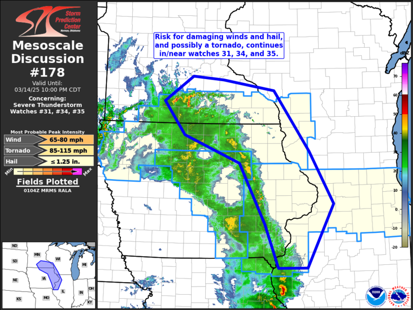
| Mesoscale Discussion 178 |
|
[an error occurred while processing this directive]
|
|
   Mesoscale Discussion 0178
   NWS Storm Prediction Center Norman OK
   0806 PM CDT Fri Mar 14 2025

   Areas affected...southern Minnesota...southwestern
   Wisconsin...northern and eastern Iowa...and northwestern Illinois

   Concerning...Severe Thunderstorm Watch 31...34...35...

   Valid 150106Z - 150300Z

   The severe weather threat for Severe Thunderstorm Watch 31, 34, 35
   continues.

   SUMMARY...Severe storms posing primarily a damaging wind risk will
   continue spreading northeastward across the mid/upper Mississippi
   Valley area.

   DISCUSSION...Latest radar loop shows an arcing/broken band of storms
   from south-central Minnesota southeastward to eastern Iowa, and
   spreading gradually toward/into northwestern Missouri.  Storms are
   not particularly robust from a reflectivity perspective -- as they
   remain largely high-based above the remnant deep/dry diurnal
   boundary layer.  Still, given very strong flow aloft, and the dry
   air remaining sub-cloud, damaging winds will locally remain possible
   over the next several hours.

   ..Goss.. 03/15/2025

   ...Please see www.spc.noaa.gov for graphic product...

   ATTN...WFO...ILX...MKX...DVN...ARX...MPX...DMX...

   LAT...LON   40369130 41329168 42659243 43259405 43979466 44529381
               44459291 44219140 42909038 41758969 40369045 40369130
|
|
Top/All Mesoscale Discussions/Forecast Products/Home
|
|


 @NWSSPC