 Note:
The expiration time in the watch graphic is amended if the watch is
replaced, cancelled or extended.
Note:
Note:
The expiration time in the watch graphic is amended if the watch is
replaced, cancelled or extended.
Note: Click for
Watch Status Reports.
SEL9
URGENT - IMMEDIATE BROADCAST REQUESTED
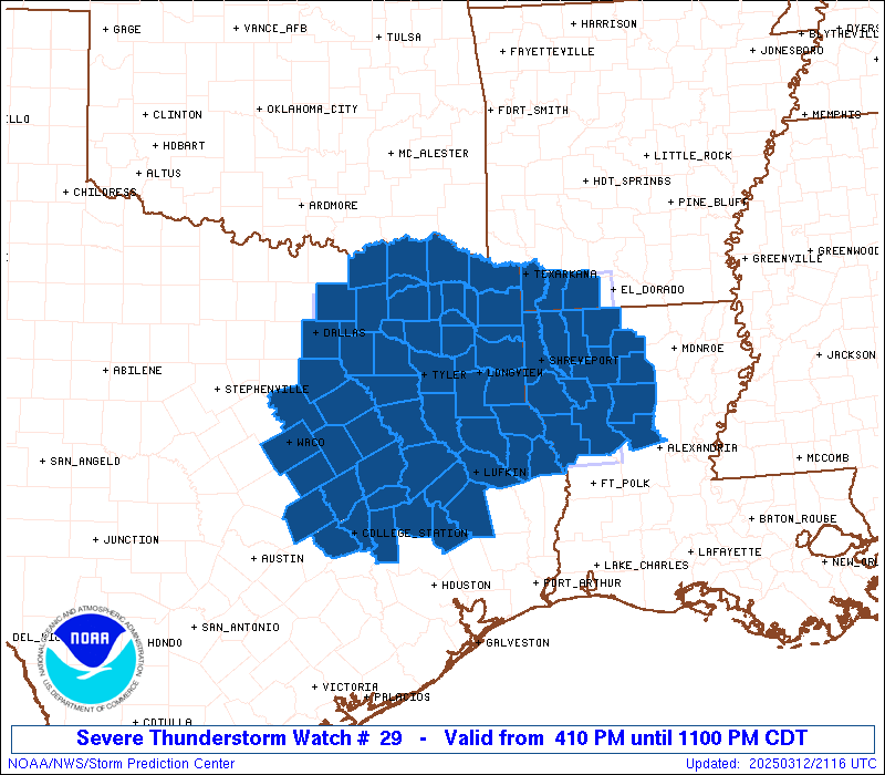
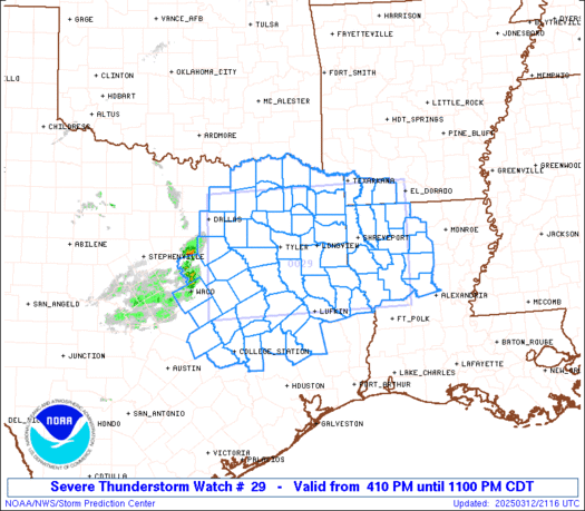
Severe Thunderstorm Watch Number 29
NWS Storm Prediction Center Norman OK
410 PM CDT Wed Mar 12 2025
The NWS Storm Prediction Center has issued a
* Severe Thunderstorm Watch for portions of
Southwest Arkansas
Northwest Louisiana
North-central and Northeast Texas
* Effective this Wednesday afternoon and evening from 410 PM
until 1100 PM CDT.
* Primary threats include...
Scattered large hail likely with isolated very large hail events
to 2.5 inches in diameter possible
Scattered damaging wind gusts to 70 mph possible
A tornado or two possible
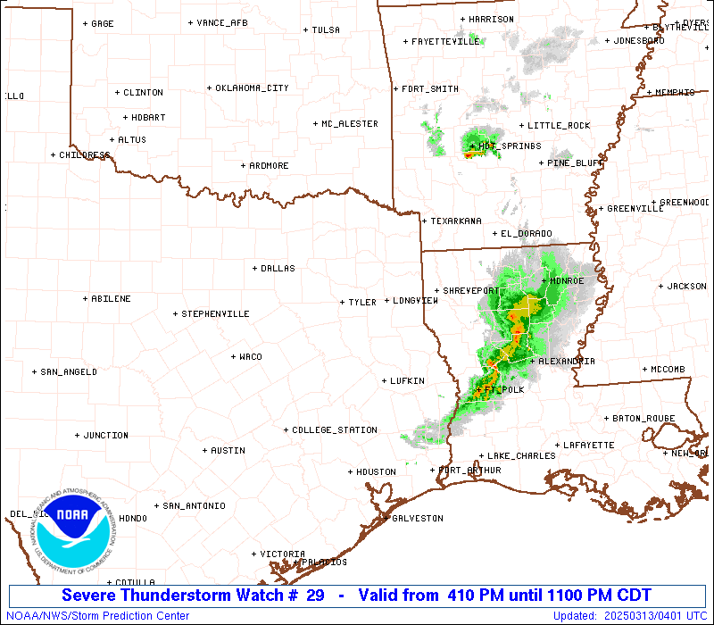
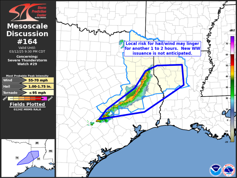
SUMMARY...Thunderstorms will continue to increase in coverage and
intensity this afternoon and early evening. Supercells should pose a
threat for large hail around 1.5-2.5 inches in diameter. A small
cluster may eventually develop and pose a threat for severe/damaging
winds of 60-70 mph through this evening.
The severe thunderstorm watch area is approximately along and 75
statute miles north and south of a line from 30 miles west northwest
of Corsicana TX to 45 miles north northeast of Natchitoches LA. For
a complete depiction of the watch see the associated watch outline
update (WOUS64 KWNS WOU9).
PRECAUTIONARY/PREPAREDNESS ACTIONS...
REMEMBER...A Severe Thunderstorm Watch means conditions are
favorable for severe thunderstorms in and close to the watch area.
Persons in these areas should be on the lookout for threatening
weather conditions and listen for later statements and possible
warnings. Severe thunderstorms can and occasionally do produce
tornadoes.
&&
AVIATION...A few severe thunderstorms with hail surface and aloft to
2.5 inches. Extreme turbulence and surface wind gusts to 60 knots. A
few cumulonimbi with maximum tops to 500. Mean storm motion vector
26040.
...Gleason
 Note:
The Aviation Watch (SAW) product is an approximation to the watch area.
The actual watch is depicted by the shaded areas.
Note:
The Aviation Watch (SAW) product is an approximation to the watch area.
The actual watch is depicted by the shaded areas.
   SAW9
   WW 29 SEVERE TSTM AR LA TX 122110Z - 130400Z
   AXIS..75 STATUTE MILES NORTH AND SOUTH OF LINE..
   30WNW CRS/CORSICANA TX/ - 45NNE IER/NATCHITOCHES LA/
   ..AVIATION COORDS.. 65NM N/S /38NNE ACT - 41WSW MLU/
   HAIL SURFACE AND ALOFT..2.5 INCHES. WIND GUSTS..60 KNOTS.
   MAX TOPS TO 500. MEAN STORM MOTION VECTOR 26040.

   LAT...LON 33289687 33439281 31269281 31119687

   THIS IS AN APPROXIMATION TO THE WATCH AREA.  FOR A
   COMPLETE DEPICTION OF THE WATCH SEE WOUS64 KWNS
   FOR WOU9.
Watch 29 Status Report Messages:
STATUS REPORT #2 ON WW 29

VALID 122300Z - 130040Z

THE SEVERE WEATHER THREAT CONTINUES ACROSS THE ENTIRE WATCH AREA.

..LYONS..03/12/25

ATTN...WFO...SHV...FWD...HGX...

&&

STATUS REPORT FOR WS 29

SEVERE WEATHER THREAT CONTINUES FOR THE FOLLOWING AREAS

ARC027-073-091-130040-

AR
.    ARKANSAS COUNTIES INCLUDED ARE

COLUMBIA	     LAFAYETTE		 MILLER
$$


LAC013-015-017-027-031-043-049-061-069-081-085-119-127-130040-

LA
.    LOUISIANA PARISHES INCLUDED ARE

BIENVILLE	     BOSSIER		 CADDO
CLAIBORNE	     DE SOTO		 GRANT
JACKSON 	     LINCOLN		 NATCHITOCHES
RED RIVER	     SABINE		 WEBSTER
WINN
$$


TXC001-005-037-041-051-063-067-073-085-113-119-139-145-147-159-
161-183-185-203-213-217-223-225-231-257-277-289-293-309-313-315-
331-343-347-349-365-373-379-387-395-397-401-403-405-407-419-423-
449-455-459-467-471-499-130040-

TX
.    TEXAS COUNTIES INCLUDED ARE

ANDERSON	     ANGELINA		 BOWIE
BRAZOS		     BURLESON		 CAMP
CASS		     CHEROKEE		 COLLIN
DALLAS		     DELTA		 ELLIS
FALLS		     FANNIN		 FRANKLIN
FREESTONE	     GREGG		 GRIMES
HARRISON	     HENDERSON		 HILL
HOPKINS 	     HOUSTON		 HUNT
KAUFMAN 	     LAMAR		 LEON
LIMESTONE	     MCLENNAN		 MADISON
MARION		     MILAM		 MORRIS
NACOGDOCHES	     NAVARRO		 PANOLA
POLK		     RAINS		 RED RIVER
ROBERTSON	     ROCKWALL		 RUSK
SABINE		     SAN AUGUSTINE	 SAN JACINTO
SHELBY		     SMITH		 TITUS
TRINITY 	     UPSHUR		 VAN ZANDT
WALKER		     WOOD
$$


THE WATCH STATUS MESSAGE IS FOR GUIDANCE PURPOSES ONLY.  PLEASE
REFER TO WATCH COUNTY NOTIFICATION STATEMENTS FOR OFFICIAL
INFORMATION ON COUNTIES...INDEPENDENT CITIES AND MARINE ZONES
CLEARED FROM SEVERE THUNDERSTORM AND TORNADO WATCHES.
$$

STATUS REPORT #1 ON WW 29

VALID 122210Z - 122340Z

THE SEVERE WEATHER THREAT CONTINUES ACROSS THE ENTIRE WATCH AREA.

..LYONS..03/12/25

ATTN...WFO...SHV...FWD...HGX...

&&

STATUS REPORT FOR WS 29

SEVERE WEATHER THREAT CONTINUES FOR THE FOLLOWING AREAS

ARC027-073-091-122340-

AR
.    ARKANSAS COUNTIES INCLUDED ARE

COLUMBIA	     LAFAYETTE		 MILLER
$$


LAC013-015-017-027-031-043-049-061-069-081-085-119-127-122340-

LA
.    LOUISIANA PARISHES INCLUDED ARE

BIENVILLE	     BOSSIER		 CADDO
CLAIBORNE	     DE SOTO		 GRANT
JACKSON 	     LINCOLN		 NATCHITOCHES
RED RIVER	     SABINE		 WEBSTER
WINN
$$


TXC001-005-037-041-051-063-067-073-085-113-119-139-145-147-159-
161-183-185-203-213-217-223-225-231-257-277-289-293-309-313-315-
331-343-347-349-365-373-379-387-395-397-401-403-405-407-419-423-
449-455-459-467-471-499-122340-

TX
.    TEXAS COUNTIES INCLUDED ARE

ANDERSON	     ANGELINA		 BOWIE
BRAZOS		     BURLESON		 CAMP
CASS		     CHEROKEE		 COLLIN
DALLAS		     DELTA		 ELLIS
FALLS		     FANNIN		 FRANKLIN
FREESTONE	     GREGG		 GRIMES
HARRISON	     HENDERSON		 HILL
HOPKINS 	     HOUSTON		 HUNT
KAUFMAN 	     LAMAR		 LEON
LIMESTONE	     MCLENNAN		 MADISON
MARION		     MILAM		 MORRIS
NACOGDOCHES	     NAVARRO		 PANOLA
POLK		     RAINS		 RED RIVER
ROBERTSON	     ROCKWALL		 RUSK
SABINE		     SAN AUGUSTINE	 SAN JACINTO
SHELBY		     SMITH		 TITUS
TRINITY 	     UPSHUR		 VAN ZANDT
WALKER		     WOOD
$$


THE WATCH STATUS MESSAGE IS FOR GUIDANCE PURPOSES ONLY.  PLEASE
REFER TO WATCH COUNTY NOTIFICATION STATEMENTS FOR OFFICIAL
INFORMATION ON COUNTIES...INDEPENDENT CITIES AND MARINE ZONES
CLEARED FROM SEVERE THUNDERSTORM AND TORNADO WATCHES.
$$
Note:
Click for Complete Product Text.
Tornadoes
Probability of 2 or more tornadoes
|
Low (20%)
|
Probability of 1 or more strong (EF2-EF5) tornadoes
|
Low (10%)
|
Wind
Probability of 10 or more severe wind events
|
Mod (50%)
|
Probability of 1 or more wind events > 65 knots
|
Low (20%)
|
Hail
Probability of 10 or more severe hail events
|
Mod (60%)
|
Probability of 1 or more hailstones > 2 inches
|
Mod (40%)
|
Combined Severe Hail/Wind
Probability of 6 or more combined severe hail/wind events
|
High (80%)
|
For each watch, probabilities for particular events inside the watch
(listed above in each table) are determined by the issuing forecaster.
The "Low" category contains probability values ranging from less than 2%
to 20% (EF2-EF5 tornadoes), less than 5% to 20% (all other probabilities),
"Moderate" from 30% to 60%, and "High" from 70% to greater than 95%.
High values are bolded and lighter in color to provide awareness of
an increased threat for a particular event.


 @NWSSPC