 Note:
The expiration time in the watch graphic is amended if the watch is
replaced, cancelled or extended.
Note:
Note:
The expiration time in the watch graphic is amended if the watch is
replaced, cancelled or extended.
Note: Click for
Watch Status Reports.
SEL8
URGENT - IMMEDIATE BROADCAST REQUESTED
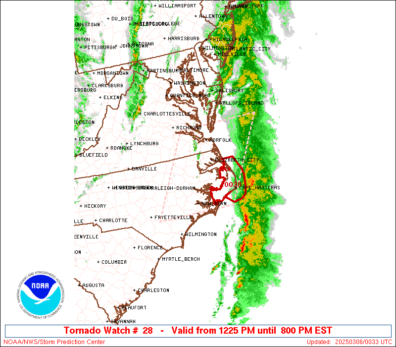
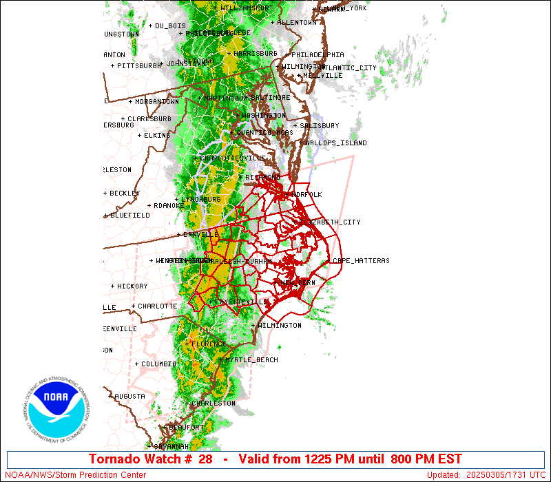
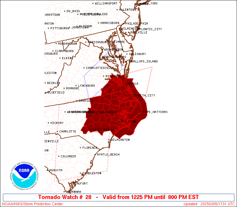
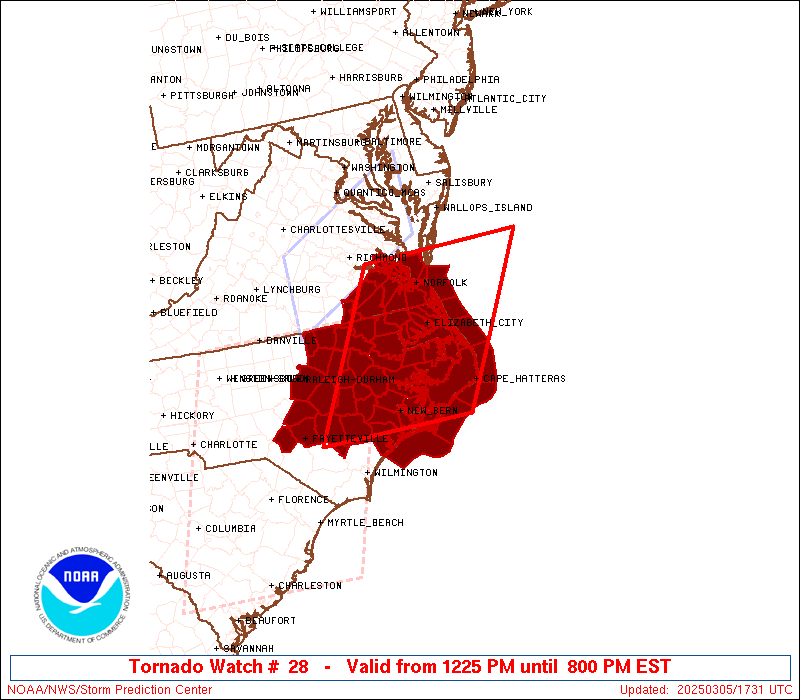
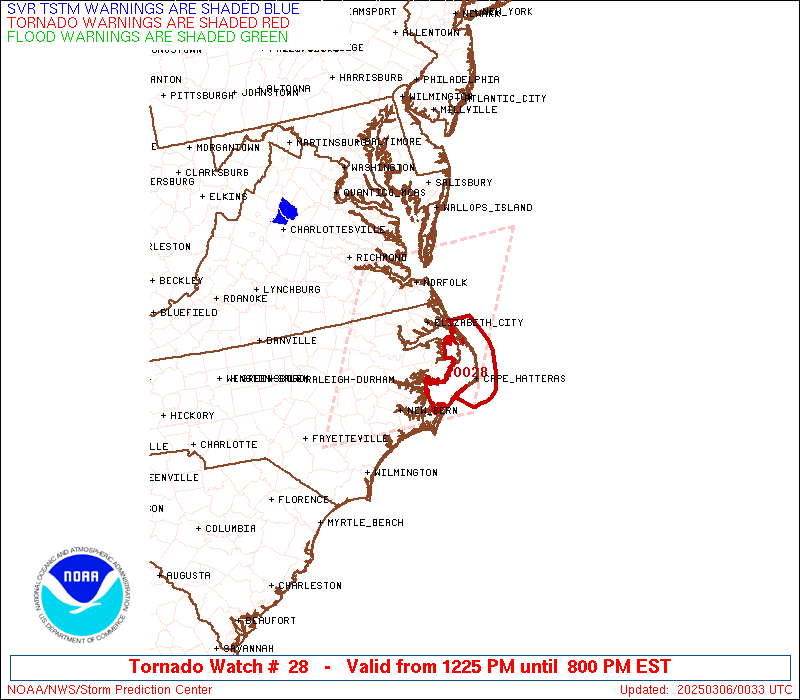
Tornado Watch Number 28
NWS Storm Prediction Center Norman OK
1225 PM EST Wed Mar 5 2025
The NWS Storm Prediction Center has issued a
* Tornado Watch for portions of
Central and Eastern North Carolina
Southeast Virginia
Coastal Waters
* Effective this Wednesday afternoon and evening from 1225 PM
until 800 PM EST.
* Primary threats include...
A couple tornadoes possible
Scattered damaging wind gusts to 70 mph likely
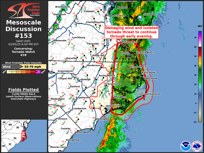
SUMMARY...A convective line continues to move eastward into more of
central/eastern NC and southeast VA. Increasing low-level moisture
coupled with strong vertical shear will support the potential for
strong wind gusts and line-embedded tornadoes through the afternoon
and into this evening.
The tornado watch area is approximately along and 80 statute miles
east and west of a line from 45 miles northeast of Norfolk VA to 20
miles south southwest of New Bern NC. For a complete depiction of
the watch see the associated watch outline update (WOUS64 KWNS
WOU8).
PRECAUTIONARY/PREPAREDNESS ACTIONS...
REMEMBER...A Tornado Watch means conditions are favorable for
tornadoes and severe thunderstorms in and close to the watch
area. Persons in these areas should be on the lookout for
threatening weather conditions and listen for later statements
and possible warnings.
&&
OTHER WATCH INFORMATION...CONTINUE...WW 26...WW 27...
AVIATION...Tornadoes and a few severe thunderstorms with hail
surface and aloft to 1 inch. Extreme turbulence and surface wind
gusts to 60 knots. A few cumulonimbi with maximum tops to 500. Mean
storm motion vector 25035.
...Mosier
 Note:
The Aviation Watch (SAW) product is an approximation to the watch area.
The actual watch is depicted by the shaded areas.
Note:
The Aviation Watch (SAW) product is an approximation to the watch area.
The actual watch is depicted by the shaded areas.
   SAW8
   WW 28 TORNADO NC VA CW 051725Z - 060100Z
   AXIS..80 STATUTE MILES EAST AND WEST OF LINE..
   45NE ORF/NORFOLK VA/ - 20SSW EWN/NEW BERN NC/
   ..AVIATION COORDS.. 70NM E/W /40NE ORF - 43NE ILM/
   HAIL SURFACE AND ALOFT..1 INCH. WIND GUSTS..60 KNOTS.
   MAX TOPS TO 500. MEAN STORM MOTION VECTOR 25035.

   LAT...LON 37347416 34797576 34797858 37347708

   THIS IS AN APPROXIMATION TO THE WATCH AREA.  FOR A
   COMPLETE DEPICTION OF THE WATCH SEE WOUS64 KWNS
   FOR WOU8.
Watch 28 Status Report Messages:
STATUS REPORT #3 ON WW 28

VALID 052235Z - 052340Z

SEVERE WEATHER THREAT CONTINUES RIGHT OF A LINE FROM 40 ESE EWN
TO 30 N ORF.

..SPC..03/05/25

ATTN...WFO...MHX...AKQ...RAH...

&&

STATUS REPORT FOR WT 28

SEVERE WEATHER THREAT CONTINUES FOR THE FOLLOWING AREAS

NCC053-055-095-139-177-052340-

NC
.    NORTH CAROLINA COUNTIES INCLUDED ARE

CURRITUCK	     DARE		 HYDE
PASQUOTANK	     TYRRELL
$$


VAC710-810-052340-

VA
.    VIRGINIA COUNTIES INCLUDED ARE


VIRGINIA INDEPENDENT CITIES INCLUDED ARE

NORFOLK 	     VIRGINIA BEACH
$$


AMZ131-135-150-152-154-156-230-231-ANZ632-633-634-656-658-
052340-

CW

.    ADJACENT COASTAL WATERS INCLUDED ARE

ALLIGATOR RIVER

PAMLICO SOUND

S OF CURRITUCK BEACH LIGHT NC TO OREGON INLET NC OUT TO 20 NM

S OF OREGON INLET NC TO CAPE HATTERAS NC OUT TO 20 NM

S OF CAPE HATTERAS NC TO OCRACOKE INLET NC OUT TO 20 NM

S OF OCRACOKE INLET NC TO CAPE LOOKOUT NC OUT TO 20 NM

ALBEMARLE SOUND

CROATAN AND ROANOKE SOUNDS

CHESAPEAKE BAY FROM NEW POINT COMFORT TO LITTLE CREEK VA

CURRITUCK SOUND

CHESAPEAKE BAY FROM LITTLE CREEK VA TO CAPE HENRY VA INCLUDING
THE CHESAPEAKE BAY BRIDGE TUNNEL

COASTAL WATERS FROM CAPE CHARLES LIGHT TO VIRGINIA-NORTH CAROLINA
BORDER OUT TO 20 NM

COASTAL WATERS FROM NC VA BORDER TO CURRITUCK BEACH LIGHT NC OUT
20 NM

$$
THE WATCH STATUS MESSAGE IS FOR GUIDANCE PURPOSES ONLY.  PLEASE
REFER TO WATCH COUNTY NOTIFICATION STATEMENTS FOR OFFICIAL
INFORMATION ON COUNTIES...INDEPENDENT CITIES AND MARINE ZONES
CLEARED FROM SEVERE THUNDERSTORM AND TORNADO WATCHES.
$$

STATUS REPORT #2 ON WW 28

VALID 052105Z - 052240Z

SEVERE WEATHER THREAT CONTINUES RIGHT OF A LINE FROM 15 S OAJ TO
25 NW EWN TO 40 ENE RWI TO 25 ENE RZZ TO 25 SE RIC TO 35 ENE RIC.

..BENTLEY..03/05/25

ATTN...WFO...MHX...AKQ...RAH...

&&

STATUS REPORT FOR WT 28

SEVERE WEATHER THREAT CONTINUES FOR THE FOLLOWING AREAS

NCC013-015-029-031-041-049-053-055-073-091-095-103-117-131-133-
137-139-143-147-177-187-052240-

NC
.    NORTH CAROLINA COUNTIES INCLUDED ARE

BEAUFORT	     BERTIE		 CAMDEN
CARTERET	     CHOWAN		 CRAVEN
CURRITUCK	     DARE		 GATES
HERTFORD	     HYDE		 JONES
MARTIN		     NORTHAMPTON	 ONSLOW
PAMLICO 	     PASQUOTANK 	 PERQUIMANS
PITT		     TYRRELL		 WASHINGTON
$$


VAC093-095-175-181-199-550-620-650-700-710-735-740-800-810-830-
052240-

VA
.    VIRGINIA COUNTIES INCLUDED ARE

ISLE OF WIGHT	     JAMES CITY 	 SOUTHAMPTON
SURRY		     YORK


VIRGINIA INDEPENDENT CITIES INCLUDED ARE

CHESAPEAKE	     FRANKLIN		 HAMPTON
NEWPORT NEWS	     NORFOLK		 POQUOSON
PORTSMOUTH	     SUFFOLK		 VIRGINIA BEACH
WILLIAMSBURG
$$


AMZ131-135-136-137-150-152-154-156-158-230-231-ANZ632-633-634-636-
637-638-656-658-052240-

CW

.    ADJACENT COASTAL WATERS INCLUDED ARE

ALLIGATOR RIVER

PAMLICO SOUND

PAMLICO AND PUNGO RIVERS

NEUSE AND BAY RIVERS

S OF CURRITUCK BEACH LIGHT NC TO OREGON INLET NC OUT TO 20 NM

S OF OREGON INLET NC TO CAPE HATTERAS NC OUT TO 20 NM

S OF CAPE HATTERAS NC TO OCRACOKE INLET NC OUT TO 20 NM

S OF OCRACOKE INLET NC TO CAPE LOOKOUT NC OUT TO 20 NM

S OF CAPE LOOKOUT NC TO SURF CITY NC OUT TO 20 NM

ALBEMARLE SOUND

CROATAN AND ROANOKE SOUNDS

CHESAPEAKE BAY FROM NEW POINT COMFORT TO LITTLE CREEK VA

CURRITUCK SOUND

CHESAPEAKE BAY FROM LITTLE CREEK VA TO CAPE HENRY VA INCLUDING
THE CHESAPEAKE BAY BRIDGE TUNNEL

YORK RIVER

JAMES RIVER FROM JAMESTOWN TO THE JAMES RIVER BRIDGE

JAMES RIVER FROM JAMES RIVER BRIDGE TO HAMPTON ROADS
BRIDGE-TUNNEL

COASTAL WATERS FROM CAPE CHARLES LIGHT TO VIRGINIA-NORTH CAROLINA
BORDER OUT TO 20 NM

COASTAL WATERS FROM NC VA BORDER TO CURRITUCK BEACH LIGHT NC OUT
20 NM

$$
THE WATCH STATUS MESSAGE IS FOR GUIDANCE PURPOSES ONLY.  PLEASE
REFER TO WATCH COUNTY NOTIFICATION STATEMENTS FOR OFFICIAL
INFORMATION ON COUNTIES...INDEPENDENT CITIES AND MARINE ZONES
CLEARED FROM SEVERE THUNDERSTORM AND TORNADO WATCHES.
$$

STATUS REPORT #1 ON WW 28

VALID 051940Z - 052040Z

SEVERE WEATHER THREAT CONTINUES RIGHT OF A LINE FROM 30 WNW ILM
TO 35 ESE FAY TO 10 WSW RWI.

..BENTLEY..03/05/25

ATTN...WFO...MHX...AKQ...RAH...

&&

STATUS REPORT FOR WT 28

SEVERE WEATHER THREAT CONTINUES FOR THE FOLLOWING AREAS

NCC013-015-029-031-041-049-053-055-061-065-073-079-083-091-095-
101-103-107-117-127-131-133-137-139-143-147-177-187-191-195-
052040-

NC
.    NORTH CAROLINA COUNTIES INCLUDED ARE

BEAUFORT	     BERTIE		 CAMDEN
CARTERET	     CHOWAN		 CRAVEN
CURRITUCK	     DARE		 DUPLIN
EDGECOMBE	     GATES		 GREENE
HALIFAX 	     HERTFORD		 HYDE
JOHNSTON	     JONES		 LENOIR
MARTIN		     NASH		 NORTHAMPTON
ONSLOW		     PAMLICO		 PASQUOTANK
PERQUIMANS	     PITT		 TYRRELL
WASHINGTON	     WAYNE		 WILSON
$$


VAC081-093-095-175-181-183-199-550-595-620-650-700-710-735-740-
800-810-830-052040-

VA
.    VIRGINIA COUNTIES INCLUDED ARE

GREENSVILLE	     ISLE OF WIGHT	 JAMES CITY
SOUTHAMPTON	     SURRY		 SUSSEX
YORK


VIRGINIA INDEPENDENT CITIES INCLUDED ARE

CHESAPEAKE	     EMPORIA		 FRANKLIN
HAMPTON 	     NEWPORT NEWS	 NORFOLK
POQUOSON	     PORTSMOUTH 	 SUFFOLK
VIRGINIA BEACH	     WILLIAMSBURG
$$


AMZ131-135-136-137-150-152-154-156-158-230-231-ANZ632-633-634-636-
637-638-656-658-052040-

CW

.    ADJACENT COASTAL WATERS INCLUDED ARE

ALLIGATOR RIVER

PAMLICO SOUND

PAMLICO AND PUNGO RIVERS

NEUSE AND BAY RIVERS

S OF CURRITUCK BEACH LIGHT NC TO OREGON INLET NC OUT TO 20 NM

S OF OREGON INLET NC TO CAPE HATTERAS NC OUT TO 20 NM

S OF CAPE HATTERAS NC TO OCRACOKE INLET NC OUT TO 20 NM

S OF OCRACOKE INLET NC TO CAPE LOOKOUT NC OUT TO 20 NM

S OF CAPE LOOKOUT NC TO SURF CITY NC OUT TO 20 NM

ALBEMARLE SOUND

CROATAN AND ROANOKE SOUNDS

CHESAPEAKE BAY FROM NEW POINT COMFORT TO LITTLE CREEK VA

CURRITUCK SOUND

CHESAPEAKE BAY FROM LITTLE CREEK VA TO CAPE HENRY VA INCLUDING
THE CHESAPEAKE BAY BRIDGE TUNNEL

YORK RIVER

JAMES RIVER FROM JAMESTOWN TO THE JAMES RIVER BRIDGE

JAMES RIVER FROM JAMES RIVER BRIDGE TO HAMPTON ROADS
BRIDGE-TUNNEL

COASTAL WATERS FROM CAPE CHARLES LIGHT TO VIRGINIA-NORTH CAROLINA
BORDER OUT TO 20 NM

COASTAL WATERS FROM NC VA BORDER TO CURRITUCK BEACH LIGHT NC OUT
20 NM

$$
THE WATCH STATUS MESSAGE IS FOR GUIDANCE PURPOSES ONLY.  PLEASE
REFER TO WATCH COUNTY NOTIFICATION STATEMENTS FOR OFFICIAL
INFORMATION ON COUNTIES...INDEPENDENT CITIES AND MARINE ZONES
CLEARED FROM SEVERE THUNDERSTORM AND TORNADO WATCHES.
$$
Note:
Click for Complete Product Text.
Tornadoes
Probability of 2 or more tornadoes
|
Mod (40%)
|
Probability of 1 or more strong (EF2-EF5) tornadoes
|
Low (20%)
|
Wind
Probability of 10 or more severe wind events
|
Mod (60%)
|
Probability of 1 or more wind events > 65 knots
|
Low (20%)
|
Hail
Probability of 10 or more severe hail events
|
Low (<5%)
|
Probability of 1 or more hailstones > 2 inches
|
Low (<5%)
|
Combined Severe Hail/Wind
Probability of 6 or more combined severe hail/wind events
|
High (70%)
|
For each watch, probabilities for particular events inside the watch
(listed above in each table) are determined by the issuing forecaster.
The "Low" category contains probability values ranging from less than 2%
to 20% (EF2-EF5 tornadoes), less than 5% to 20% (all other probabilities),
"Moderate" from 30% to 60%, and "High" from 70% to greater than 95%.
High values are bolded and lighter in color to provide awareness of
an increased threat for a particular event.


 @NWSSPC