|
| Mesoscale Discussion 164 |
|
File not found.
|
|
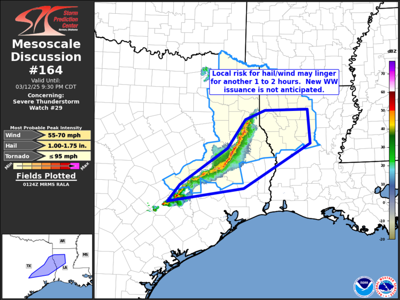
   Mesoscale Discussion 0164
   NWS Storm Prediction Center Norman OK
   0826 PM CDT Wed Mar 12 2025

   Areas affected...eastern Texas into western Louisiana

   Concerning...Severe Thunderstorm Watch 29...

   Valid 130126Z - 130230Z

   The severe weather threat for Severe Thunderstorm Watch 29
   continues.

   SUMMARY...Severe-weather potential may linger locally for another 1
   to 2 hours with the ongoing convective band over eastern Texas.

   DISCUSSION...Latest radar loop shows a semi-continuous band of
   storms advancing eastward across eastern Texas -- and remains
   largely sub-severe.  The convection is moving through the axis of
   most substantial instability at this time, per latest RAP-based
   objective analysis, which suggests that lingering severe risk should
   begin to diminish over the next 1 to 2 hours.  This is further
   supported by evening RAOBs, which -- upon continued/gradual
   boundary-layer cooling -- suggests an environment becoming
   increasingly less supportive of any ramp-up on convective
   intensity/severe potential.

   ..Goss.. 03/13/2025

   ...Please see www.spc.noaa.gov for graphic product...

   ATTN...WFO...LCH...SHV...HGX...EWX...

   LAT...LON   32399387 32429256 31529250 30359451 30019680 30459644
               31419501 32159446 32399387
|
|
Top/All Mesoscale Discussions/Forecast Products/Home
|
|


 @NWSSPC