 Note:
The expiration time in the watch graphic is amended if the watch is
replaced, cancelled or extended.
Note:
Note:
The expiration time in the watch graphic is amended if the watch is
replaced, cancelled or extended.
Note: Click for
Watch Status Reports.
SEL6
URGENT - IMMEDIATE BROADCAST REQUESTED
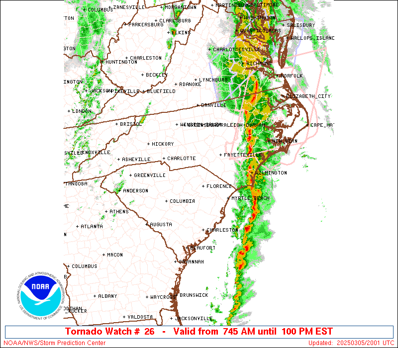
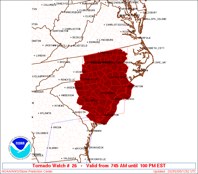
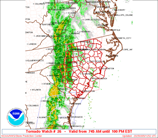
Tornado Watch Number 26
NWS Storm Prediction Center Norman OK
745 AM EST Wed Mar 5 2025
The NWS Storm Prediction Center has issued a
* Tornado Watch for portions of
Central and Eastern North Carolina
Central and Eastern South Carolina
Coastal Waters
* Effective this Wednesday morning and afternoon from 745 AM
until 100 PM EST.
* Primary threats include...
A couple tornadoes possible
Scattered damaging wind gusts to 70 mph likely
SUMMARY...A broken squall line will continue east across the Watch
area through the midday into the early afternoon. Very strong wind
fields and a destabilizing airmass will support the potential for
embedded circulations in the squall line to pose a risk for damaging
gusts (55-70 mph) and a threat for tornadoes.
The tornado watch area is approximately along and 95 statute miles
east and west of a line from 50 miles north of Raleigh NC to 10
miles south of Charleston SC. For a complete depiction of the watch
see the associated watch outline update (WOUS64 KWNS WOU6).
PRECAUTIONARY/PREPAREDNESS ACTIONS...
REMEMBER...A Tornado Watch means conditions are favorable for
tornadoes and severe thunderstorms in and close to the watch
area. Persons in these areas should be on the lookout for
threatening weather conditions and listen for later statements
and possible warnings.
&&
OTHER WATCH INFORMATION...CONTINUE...WW 25...
AVIATION...Tornadoes and a few severe thunderstorms with hail
surface and aloft to 0.5 inches. Extreme turbulence and surface wind
gusts to 60 knots. A few cumulonimbi with maximum tops to 300. Mean
storm motion vector 24035.
...Smith
 Note:
The Aviation Watch (SAW) product is an approximation to the watch area.
The actual watch is depicted by the shaded areas.
Note:
The Aviation Watch (SAW) product is an approximation to the watch area.
The actual watch is depicted by the shaded areas.
   SAW6
   WW 26 TORNADO NC SC CW 051245Z - 051800Z
   AXIS..95 STATUTE MILES EAST AND WEST OF LINE..
   50N RDU/RALEIGH NC/ - 10S CHS/CHARLESTON SC/
   ..AVIATION COORDS.. 80NM E/W /43N RDU - 8S CHS/
   HAIL SURFACE AND ALOFT..0.5 INCH. WIND GUSTS..60 KNOTS.
   MAX TOPS TO 300. MEAN STORM MOTION VECTOR 24035.

   LAT...LON 36577707 32747840 32748166 36578049

   THIS IS AN APPROXIMATION TO THE WATCH AREA.  FOR A
   COMPLETE DEPICTION OF THE WATCH SEE WOUS64 KWNS
   FOR WOU6.
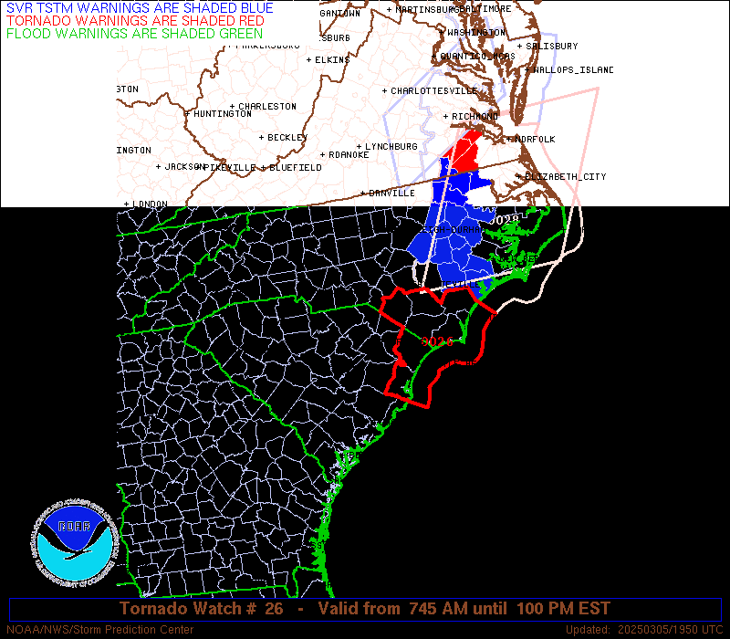
Watch 26 Status Report Messages:
STATUS REPORT #2 ON WW 26

VALID 051725Z - 051840Z

SEVERE WEATHER THREAT CONTINUES RIGHT OF A LINE FROM 30 SW CHS TO
30 NNW CHS TO FLO TO 20 S SOP TO 15 NNW RDU TO 30 NW AVC.

..BENTLEY..03/05/25

ATTN...WFO...RAH...ILM...GSP...RNK...MHX...CHS...CAE...

&&

STATUS REPORT FOR WT 26

SEVERE WEATHER THREAT CONTINUES FOR THE FOLLOWING AREAS

NCC017-019-047-051-061-063-065-069-077-079-083-085-093-101-107-
127-129-141-155-163-165-181-183-185-191-195-051840-

NC
.    NORTH CAROLINA COUNTIES INCLUDED ARE

BLADEN		     BRUNSWICK		 COLUMBUS
CUMBERLAND	     DUPLIN		 DURHAM
EDGECOMBE	     FRANKLIN		 GRANVILLE
GREENE		     HALIFAX		 HARNETT
HOKE		     JOHNSTON		 LENOIR
NASH		     NEW HANOVER	 PENDER
ROBESON 	     SAMPSON		 SCOTLAND
VANCE		     WAKE		 WARREN
WAYNE		     WILSON
$$


SCC015-019-033-041-043-051-067-089-051840-

SC
.    SOUTH CAROLINA COUNTIES INCLUDED ARE

BERKELEY	     CHARLESTON 	 DILLON
FLORENCE	     GEORGETOWN 	 HORRY
MARION		     WILLIAMSBURG
$$


AMZ250-252-254-256-330-350-051840-

CW

.    ADJACENT COASTAL WATERS INCLUDED ARE

COASTAL WATERS FROM SURF CITY TO CAPE FEAR NC OUT 20 NM

COASTAL WATERS FROM CAPE FEAR NC TO LITTLE RIVER INLET SC OUT 20
NM

COASTAL WATERS FROM LITTLE RIVER INLET TO MURRELLS INLET SC OUT
20 NM

COASTAL WATERS FROM MURRELLS INLET TO SOUTH SANTEE RIVER SC OUT
20 NM

CHARLESTON HARBOR

COASTAL WATERS FROM SOUTH SANTEE RIVER TO EDISTO BEACH SC OUT 20
NM

$$
THE WATCH STATUS MESSAGE IS FOR GUIDANCE PURPOSES ONLY.  PLEASE
REFER TO WATCH COUNTY NOTIFICATION STATEMENTS FOR OFFICIAL
INFORMATION ON COUNTIES...INDEPENDENT CITIES AND MARINE ZONES
CLEARED FROM SEVERE THUNDERSTORM AND TORNADO WATCHES.
$$

STATUS REPORT #1 ON WW 26

VALID 051550Z - 051640Z

SEVERE WEATHER THREAT CONTINUES RIGHT OF A LINE FROM 35 NNE SAV
TO 25 SE OGB TO 30 WSW FLO TO 15 WSW SOP TO 35 SE GSO TO 20 S DAN
TO 25 SSE LYH.

..BENTLEY..03/05/25

ATTN...WFO...RAH...ILM...GSP...RNK...MHX...CHS...CAE...

&&

STATUS REPORT FOR WT 26

SEVERE WEATHER THREAT CONTINUES FOR THE FOLLOWING AREAS

NCC001-017-019-037-047-051-061-063-065-069-077-079-083-085-093-
101-105-107-125-127-129-135-141-145-153-155-163-165-181-183-185-
191-195-051640-

NC
.    NORTH CAROLINA COUNTIES INCLUDED ARE

ALAMANCE	     BLADEN		 BRUNSWICK
CHATHAM 	     COLUMBUS		 CUMBERLAND
DUPLIN		     DURHAM		 EDGECOMBE
FRANKLIN	     GRANVILLE		 GREENE
HALIFAX 	     HARNETT		 HOKE
JOHNSTON	     LEE		 LENOIR
MOORE		     NASH		 NEW HANOVER
ORANGE		     PENDER		 PERSON
RICHMOND	     ROBESON		 SAMPSON
SCOTLAND	     VANCE		 WAKE
WARREN		     WAYNE		 WILSON
$$


SCC015-019-027-029-031-033-035-041-043-051-067-069-089-051640-

SC
.    SOUTH CAROLINA COUNTIES INCLUDED ARE

BERKELEY	     CHARLESTON 	 CLARENDON
COLLETON	     DARLINGTON 	 DILLON
DORCHESTER	     FLORENCE		 GEORGETOWN
HORRY		     MARION		 MARLBORO
WILLIAMSBURG
$$


AMZ250-252-254-256-330-350-051640-

CW

.    ADJACENT COASTAL WATERS INCLUDED ARE

COASTAL WATERS FROM SURF CITY TO CAPE FEAR NC OUT 20 NM

COASTAL WATERS FROM CAPE FEAR NC TO LITTLE RIVER INLET SC OUT 20
NM

COASTAL WATERS FROM LITTLE RIVER INLET TO MURRELLS INLET SC OUT
20 NM

COASTAL WATERS FROM MURRELLS INLET TO SOUTH SANTEE RIVER SC OUT
20 NM

CHARLESTON HARBOR

COASTAL WATERS FROM SOUTH SANTEE RIVER TO EDISTO BEACH SC OUT 20
NM

$$
THE WATCH STATUS MESSAGE IS FOR GUIDANCE PURPOSES ONLY.  PLEASE
REFER TO WATCH COUNTY NOTIFICATION STATEMENTS FOR OFFICIAL
INFORMATION ON COUNTIES...INDEPENDENT CITIES AND MARINE ZONES
CLEARED FROM SEVERE THUNDERSTORM AND TORNADO WATCHES.
$$
Note:
Click for Complete Product Text.
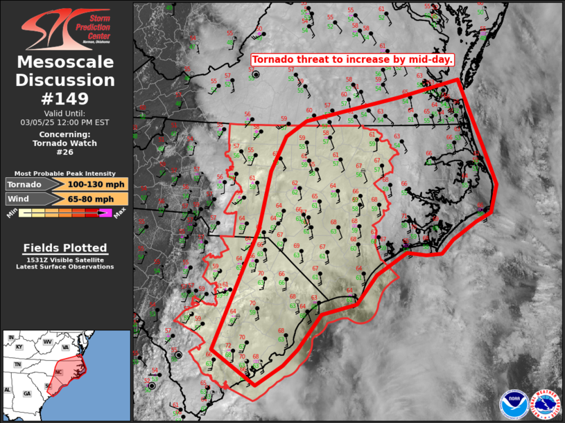
Tornadoes
Probability of 2 or more tornadoes
|
Mod (40%)
|
Probability of 1 or more strong (EF2-EF5) tornadoes
|
Low (20%)
|
Wind
Probability of 10 or more severe wind events
|
Mod (60%)
|
Probability of 1 or more wind events > 65 knots
|
Low (10%)
|
Hail
Probability of 10 or more severe hail events
|
Low (<5%)
|
Probability of 1 or more hailstones > 2 inches
|
Low (<5%)
|
Combined Severe Hail/Wind
Probability of 6 or more combined severe hail/wind events
|
High (70%)
|
For each watch, probabilities for particular events inside the watch
(listed above in each table) are determined by the issuing forecaster.
The "Low" category contains probability values ranging from less than 2%
to 20% (EF2-EF5 tornadoes), less than 5% to 20% (all other probabilities),
"Moderate" from 30% to 60%, and "High" from 70% to greater than 95%.
High values are bolded and lighter in color to provide awareness of
an increased threat for a particular event.


 @NWSSPC