|
| Mesoscale Discussion 153 |
|
[an error occurred while processing this directive]
|
|
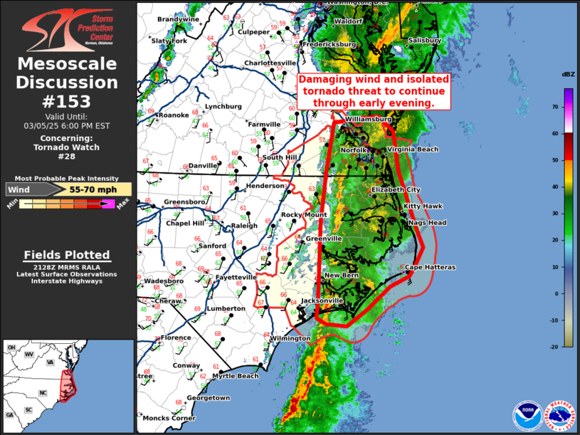
   Mesoscale Discussion 0153
   NWS Storm Prediction Center Norman OK
   0330 PM CST Wed Mar 05 2025

   Areas affected...eastern North Carolina and southeast Virginia

   Concerning...Tornado Watch 28...

   Valid 052130Z - 052300Z

   The severe weather threat for Tornado Watch 28 continues.

   SUMMARY...The damaging wind threat will continue through early
   evening.

   DISCUSSION...A squall line has started to lose its definition
   somewhat across eastern North Carolina as leading stratiform
   precipitation has started to stabilize an already weakly unstable
   boundary layer. While the line is not as intense as it was earlier
   this afternoon, a threat for damaging wind gusts remains possible to
   the Atlantic coast given the strength of the low-level wind field
   across the region (75 knots at 1km on MHX VWP). Several strong
   supercells with strong low-level circulation were observed from the
   KLTX WSR-88D off the North Carolina coast over the past 1 to 2
   hours. However, as these storms approached the coast, they weakened,
   suggesting a more hostile low-level instability present across land
   areas.

   By 2330Z the threat will likely have ended across tornado watch 28
   as the squall line should be in the western Atlantic by that time.

   ..Bentley.. 03/05/2025

   ...Please see www.spc.noaa.gov for graphic product...

   ATTN...WFO...AKQ...MHX...

   LAT...LON   34477664 34497698 34587714 34747713 34937712 35907708
               36607700 37287687 37377610 37177585 36607575 35807545
               35557534 35267551 35167559 35027591 34697630 34477664
|
|
Top/All Mesoscale Discussions/Forecast Products/Home
|
|


 @NWSSPC