Note:
The expiration time in the watch graphic is amended if the watch is
replaced, cancelled or extended.
Note:
Note:
The expiration time in the watch graphic is amended if the watch is
replaced, cancelled or extended.
Note: Click for
Watch Status Reports.
SEL4
URGENT - IMMEDIATE BROADCAST REQUESTED
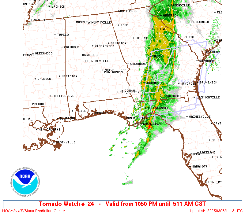
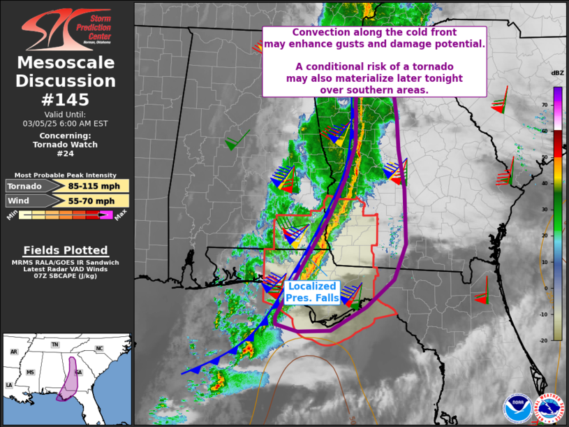
Tornado Watch Number 24
NWS Storm Prediction Center Norman OK
1050 PM CST Tue Mar 4 2025
The NWS Storm Prediction Center has issued a
* Tornado Watch for portions of
Southeast Alabama
Florida Panhandle
Southwest Georgia
Coastal Waters
* Effective this Tuesday night and Wednesday morning from 1050 PM
until 600 AM CST.
* Primary threats include...
A couple tornadoes possible
Scattered damaging wind gusts to 70 mph likely
SUMMARY...A band of storms will continue to progress eastward across
the region through late evening and overnight, with tornado and
damaging wind risks.
The tornado watch area is approximately along and 75 statute miles
north and south of a line from 45 miles northwest of Panama City FL
to 20 miles north northeast of Tallahassee FL. For a complete
depiction of the watch see the associated watch outline update
(WOUS64 KWNS WOU4).
PRECAUTIONARY/PREPAREDNESS ACTIONS...
REMEMBER...A Tornado Watch means conditions are favorable for
tornadoes and severe thunderstorms in and close to the watch
area. Persons in these areas should be on the lookout for
threatening weather conditions and listen for later statements
and possible warnings.
&&
OTHER WATCH INFORMATION...CONTINUE...WW 22...WW 23...
AVIATION...Tornadoes and a few severe thunderstorms with hail
surface and aloft to 0.5 inches. Extreme turbulence and surface wind
gusts to 60 knots. A few cumulonimbi with maximum tops to 450. Mean
storm motion vector 25030.
...Guyer

SEL4
URGENT - IMMEDIATE BROADCAST REQUESTED
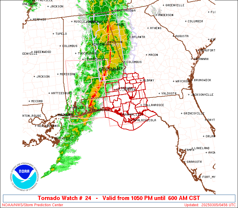
Tornado Watch Number 24
NWS Storm Prediction Center Norman OK
1050 PM CST Tue Mar 4 2025
The NWS Storm Prediction Center has issued a
* Tornado Watch for portions of
Southeast Alabama
Florida Panhandle
Southwest Georgia
Coastal Waters
* Effective this Tuesday night and Wednesday morning from 1050 PM
until 600 AM CST.
* Primary threats include...
A couple tornadoes possible
Scattered damaging wind gusts to 70 mph likely
SUMMARY...A band of storms will continue to progress eastward across
the region through late evening and overnight, with tornado and
damaging wind risks.
The tornado watch area is approximately along and 75 statute miles
north and south of a line from 45 miles northwest of Panama City FL
to 20 miles north northeast of Tallahassee FL. For a complete
depiction of the watch see the associated watch outline update
(WOUS64 KWNS WOU4).
PRECAUTIONARY/PREPAREDNESS ACTIONS...
REMEMBER...A Tornado Watch means conditions are favorable for
tornadoes and severe thunderstorms in and close to the watch
area. Persons in these areas should be on the lookout for
threatening weather conditions and listen for later statements
and possible warnings.
&&
OTHER WATCH INFORMATION...CONTINUE...WW 22...WW 23...
AVIATION...Tornadoes and a few severe thunderstorms with hail
surface and aloft to 0.5 inches. Extreme turbulence and surface wind
gusts to 60 knots. A few cumulonimbi with maximum tops to 450. Mean
storm motion vector 25030.
...Guyer
 Note:
The Aviation Watch (SAW) product is an approximation to the watch area.
The actual watch is depicted by the shaded areas.
Note:
The Aviation Watch (SAW) product is an approximation to the watch area.
The actual watch is depicted by the shaded areas.
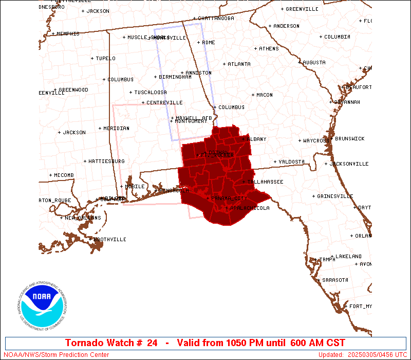
   SAW4
   WW 24 TORNADO AL FL GA CW 050450Z - 051200Z
   AXIS..75 STATUTE MILES NORTH AND SOUTH OF LINE..
   45NW PFN/PANAMA CITY FL/ - 20NNE TLH/TALLAHASSEE FL/
   ..AVIATION COORDS.. 65NM N/S /26ESE CEW - 10NE TLH/
   HAIL SURFACE AND ALOFT..0.5 INCH. WIND GUSTS..60 KNOTS.
   MAX TOPS TO 450. MEAN STORM MOTION VECTOR 25030.

   LAT...LON 31768622 31758422 29588422 29598622

   THIS IS AN APPROXIMATION TO THE WATCH AREA.  FOR A
   COMPLETE DEPICTION OF THE WATCH SEE WOUS64 KWNS
   FOR WOU4.
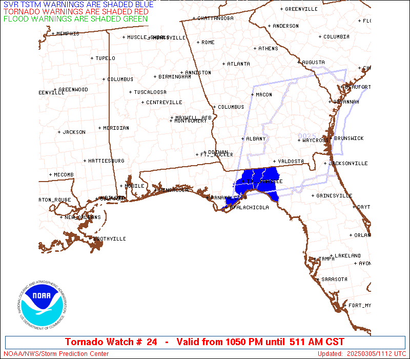
Watch 24 Status Report Messages:
STATUS REPORT #2 ON WW 24

VALID 050920Z - 051040Z

SEVERE WEATHER THREAT CONTINUES RIGHT OF A LINE FROM 50 SW AAF TO
20 WNW AAF TO 35 WSW TLH TO 20 NW TLH TO 25 W MGR TO 10 E ABY TO
30 NE ABY.

..JEWELL..03/05/25

ATTN...WFO...TAE...

&&

STATUS REPORT FOR WT 24

SEVERE WEATHER THREAT CONTINUES FOR THE FOLLOWING AREAS

FLC005-013-037-039-045-063-073-077-129-051040-

FL
.    FLORIDA COUNTIES INCLUDED ARE

BAY		     CALHOUN		 FRANKLIN
GADSDEN 	     GULF		 JACKSON
LEON		     LIBERTY		 WAKULLA
$$


GAC007-037-087-095-131-201-205-253-273-051040-

GA
.    GEORGIA COUNTIES INCLUDED ARE

BAKER		     CALHOUN		 DECATUR
DOUGHERTY	     GRADY		 MILLER
MITCHELL	     SEMINOLE		 TERRELL
$$


GMZ730-750-752-755-051040-

CW

.    ADJACENT COASTAL WATERS INCLUDED ARE

APALACHEE BAY OR COASTAL WATERS FROM KEATON BEACH TO OCHLOCKONEE
RIVER FL OUT TO 20 NM

COASTAL WATERS FROM OKALOOSA-WALTON COUNTY LINE TO MEXICO BEACH
OUT 20 NM

COASTAL WATERS FROM MEXICO BEACH TO APALACHICOLA OUT 20 NM

COASTAL WATERS FROM  OCHLOCKONEE RIVER TO APALACHICOLA FL OUT TO
20 NM

$$
THE WATCH STATUS MESSAGE IS FOR GUIDANCE PURPOSES ONLY.  PLEASE
REFER TO WATCH COUNTY NOTIFICATION STATEMENTS FOR OFFICIAL
INFORMATION ON COUNTIES...INDEPENDENT CITIES AND MARINE ZONES
CLEARED FROM SEVERE THUNDERSTORM AND TORNADO WATCHES.
$$

STATUS REPORT #1 ON WW 24

VALID 050820Z - 050940Z

SEVERE WEATHER THREAT CONTINUES RIGHT OF A LINE FROM 65 SSW PFN
TO 10 SSE PFN TO 10 SE MAI TO 30 NE MAI TO 20 NW ABY TO 35 N ABY.

..JEWELL..03/05/25

ATTN...WFO...TAE...

&&

STATUS REPORT FOR WT 24

SEVERE WEATHER THREAT CONTINUES FOR THE FOLLOWING AREAS

FLC005-013-037-039-045-063-073-077-129-050940-

FL
.    FLORIDA COUNTIES INCLUDED ARE

BAY		     CALHOUN		 FRANKLIN
GADSDEN 	     GULF		 JACKSON
LEON		     LIBERTY		 WAKULLA
$$


GAC007-037-087-095-131-201-205-253-273-050940-

GA
.    GEORGIA COUNTIES INCLUDED ARE

BAKER		     CALHOUN		 DECATUR
DOUGHERTY	     GRADY		 MILLER
MITCHELL	     SEMINOLE		 TERRELL
$$


GMZ730-750-752-755-050940-

CW

.    ADJACENT COASTAL WATERS INCLUDED ARE

APALACHEE BAY OR COASTAL WATERS FROM KEATON BEACH TO OCHLOCKONEE
RIVER FL OUT TO 20 NM

COASTAL WATERS FROM OKALOOSA-WALTON COUNTY LINE TO MEXICO BEACH
OUT 20 NM

COASTAL WATERS FROM MEXICO BEACH TO APALACHICOLA OUT 20 NM

COASTAL WATERS FROM  OCHLOCKONEE RIVER TO APALACHICOLA FL OUT TO
20 NM

$$
THE WATCH STATUS MESSAGE IS FOR GUIDANCE PURPOSES ONLY.  PLEASE
REFER TO WATCH COUNTY NOTIFICATION STATEMENTS FOR OFFICIAL
INFORMATION ON COUNTIES...INDEPENDENT CITIES AND MARINE ZONES
CLEARED FROM SEVERE THUNDERSTORM AND TORNADO WATCHES.
$$
Note:
Click for Complete Product Text.
Tornadoes
Probability of 2 or more tornadoes
|
Mod (40%)
|
Probability of 1 or more strong (EF2-EF5) tornadoes
|
Low (20%)
|
Wind
Probability of 10 or more severe wind events
|
Mod (60%)
|
Probability of 1 or more wind events > 65 knots
|
Low (20%)
|
Hail
Probability of 10 or more severe hail events
|
Low (<5%)
|
Probability of 1 or more hailstones > 2 inches
|
Low (<5%)
|
Combined Severe Hail/Wind
Probability of 6 or more combined severe hail/wind events
|
High (80%)
|
For each watch, probabilities for particular events inside the watch
(listed above in each table) are determined by the issuing forecaster.
The "Low" category contains probability values ranging from less than 2%
to 20% (EF2-EF5 tornadoes), less than 5% to 20% (all other probabilities),
"Moderate" from 30% to 60%, and "High" from 70% to greater than 95%.
High values are bolded and lighter in color to provide awareness of
an increased threat for a particular event.


 @NWSSPC