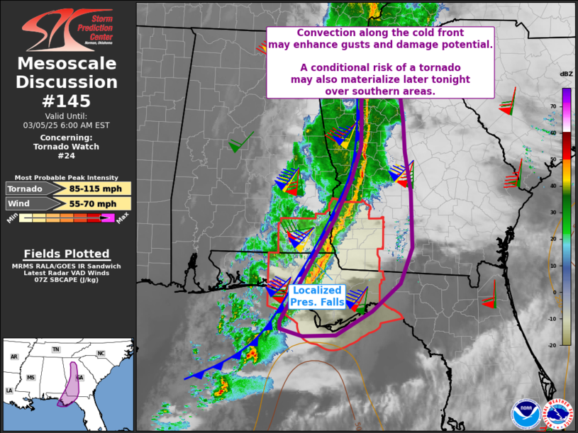
   Mesoscale Discussion 0145
   NWS Storm Prediction Center Norman OK
   0135 AM CST Wed Mar 05 2025

   Areas affected...Florida Panhandle into parts of central to southern
   Georgia

   Concerning...Tornado Watch 24...

   Valid 050735Z - 051100Z

   The severe weather threat for Tornado Watch 24 continues.

   SUMMARY...Sporadic gusts near severe levels will remain possible
   along the cold front as it progresses into central and southern
   Georgia, and sweeps across the Florida Panhandle.

   DISCUSSION...A high-reflectivity line of thunderstorms persists
   along the cold front, with the bulk of the lightning activity
   extending from southwest GA southward. While surface-based CAPE is
   very low in most areas of GA, extreme shear coupled with brief heavy
   precipitation within the line may augment surface gusts.

   Meanwhile, slightly better moisture with low 60s F dewpoints are now
   into southern GA, with mid 60s along the northern Gulf Coast. Robust
   supercells are indicated well offshore, and should largely remain
   over the water for much of the night.

   Otherwise, the primary area of concern will be the frontal segment
   now over the FL Panhandle and extending into southwest GA. Here,
   pressure falls are currently maximized, and gusts over 44 kt have
   been measured recently. As such, the primary risk over the next few
   hours should remain largely within tornado watch 24, but portions of
   the squall line just north and moving into central GA will need to
   be monitored for watch potential given such strong shear and readily
   gusty wind environment.

   ..Jewell.. 03/05/2025

   ...Please see www.spc.noaa.gov for graphic product...

   ATTN...WFO...FFC...TAE...

   LAT...LON   29768613 30378578 31618501 32298468 32928445 33458444
               33658446 33868443 34278451 34498433 34468393 34148365
               33408356 32818353 32108340 31088338 30448363 29948423
               29518498 29498567 29638613 29768613
|


 @NWSSPC