Note:
The expiration time in the watch graphic is amended if the watch is
replaced, cancelled or extended.
Note:
Note:
The expiration time in the watch graphic is amended if the watch is
replaced, cancelled or extended.
Note: Click for
Watch Status Reports.
SEL3
URGENT - IMMEDIATE BROADCAST REQUESTED
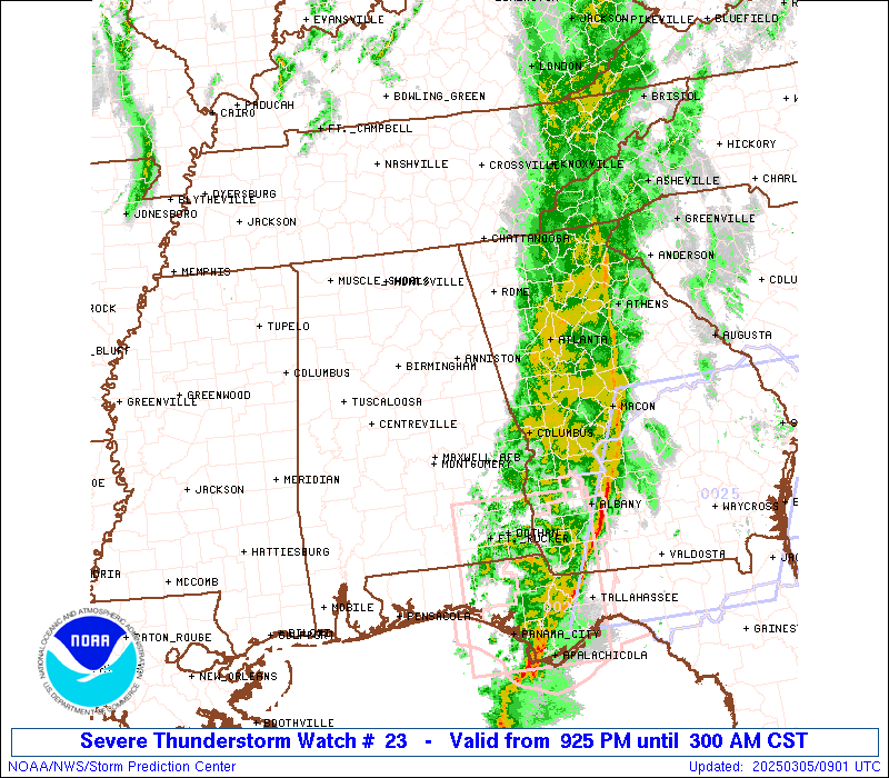
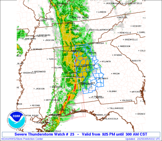
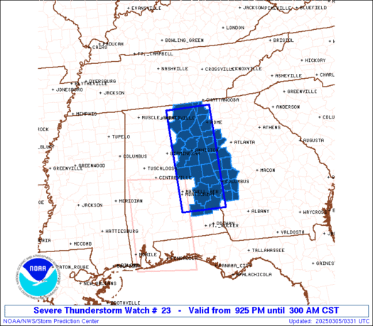
Severe Thunderstorm Watch Number 23
NWS Storm Prediction Center Norman OK
925 PM CST Tue Mar 4 2025
The NWS Storm Prediction Center has issued a
* Severe Thunderstorm Watch for portions of
Eastern Alabama
Western Georgia
* Effective this Tuesday night and Wednesday morning from 925 PM
until 300 AM CST.
* Primary threats include...
Scattered damaging wind gusts to 70 mph likely
A tornado or two possible
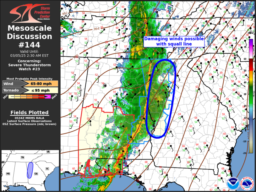
SUMMARY...A line of storms will continue to pose a risk for wind
damage, and possibly a brief tornado risk, from eastern Alabama into
western Georgia.
The severe thunderstorm watch area is approximately along and 45
statute miles east and west of a line from 50 miles northwest of
Rome GA to 20 miles east southeast of Troy AL. For a complete
depiction of the watch see the associated watch outline update
(WOUS64 KWNS WOU3).
PRECAUTIONARY/PREPAREDNESS ACTIONS...
REMEMBER...A Severe Thunderstorm Watch means conditions are
favorable for severe thunderstorms in and close to the watch area.
Persons in these areas should be on the lookout for threatening
weather conditions and listen for later statements and possible
warnings. Severe thunderstorms can and occasionally do produce
tornadoes.
&&
OTHER WATCH INFORMATION...CONTINUE...WW 22...
AVIATION...A few severe thunderstorms with hail surface and aloft to
0.5 inches. Extreme turbulence and surface wind gusts to 60 knots. A
few cumulonimbi with maximum tops to 450. Mean storm motion vector
24040.
...Guyer
   SEL3

   URGENT - IMMEDIATE BROADCAST REQUESTED
   Severe Thunderstorm Watch Number 23
   NWS Storm Prediction Center Norman OK
   925 PM CST Tue Mar 4 2025

   The NWS Storm Prediction Center has issued a

   * Severe Thunderstorm Watch for portions of
     Eastern Alabama
     Western Georgia

   * Effective this Tuesday night and Wednesday morning from 925 PM
     until 300 AM CST.

   * Primary threats include...
     Scattered damaging wind gusts to 70 mph likely
     A tornado or two possible

   SUMMARY...A line of storms will continue to pose a risk for wind
   damage, and possibly a brief tornado risk, from eastern Alabama into
   western Georgia.

   The severe thunderstorm watch area is approximately along and 45
   statute miles east and west of a line from 50 miles northwest of
   Rome GA to 20 miles east southeast of Troy AL. For a complete
   depiction of the watch see the associated watch outline update
   (WOUS64 KWNS WOU3).

   PRECAUTIONARY/PREPAREDNESS ACTIONS...

   REMEMBER...A Severe Thunderstorm Watch means conditions are
   favorable for severe thunderstorms in and close to the watch area.
   Persons in these areas should be on the lookout for threatening
   weather conditions and listen for later statements and possible
   warnings. Severe thunderstorms can and occasionally do produce
   tornadoes.

   &&

   OTHER WATCH INFORMATION...CONTINUE...WW 22...

   AVIATION...A few severe thunderstorms with hail surface and aloft to
   0.5 inches. Extreme turbulence and surface wind gusts to 60 knots. A
   few cumulonimbi with maximum tops to 450. Mean storm motion vector
   24040.

   ...Guyer
 Note:
The Aviation Watch (SAW) product is an approximation to the watch area.
The actual watch is depicted by the shaded areas.
Note:
The Aviation Watch (SAW) product is an approximation to the watch area.
The actual watch is depicted by the shaded areas.
   SAW3
   WW 23 SEVERE TSTM AL GA 050325Z - 050900Z
   AXIS..45 STATUTE MILES EAST AND WEST OF LINE..
   50NW RMG/ROME GA/ - 20ESE TOI/TROY AL/
   ..AVIATION COORDS.. 40NM E/W /32W GQO - 42SE MGM/
   HAIL SURFACE AND ALOFT..0.5 INCH. WIND GUSTS..60 KNOTS.
   MAX TOPS TO 450. MEAN STORM MOTION VECTOR 24040.

   LAT...LON 34868500 31768494 31768647 34868659

   THIS IS AN APPROXIMATION TO THE WATCH AREA.  FOR A
   COMPLETE DEPICTION OF THE WATCH SEE WOUS64 KWNS
   FOR WOU3.
Watch 23 Status Report Messages:
STATUS REPORT #1 ON WW 23

VALID 050450Z - 050540Z

SEVERE WEATHER THREAT CONTINUES RIGHT OF A LINE FROM 25 S MGM TO
30 WNW AUO TO 30 WSW CHA.

..SPC..03/05/25

ATTN...WFO...BMX...HUN...FFC...

&&

STATUS REPORT FOR WS 23

SEVERE WEATHER THREAT CONTINUES FOR THE FOLLOWING AREAS

ALC005-011-015-017-019-027-029-049-055-081-087-109-111-113-123-
050540-

AL
.    ALABAMA COUNTIES INCLUDED ARE

BARBOUR 	     BULLOCK		 CALHOUN
CHAMBERS	     CHEROKEE		 CLAY
CLEBURNE	     DEKALB		 ETOWAH
LEE		     MACON		 PIKE
RANDOLPH	     RUSSELL		 TALLAPOOSA
$$


GAC015-045-047-053-055-057-063-067-077-083-089-097-111-113-115-
121-123-129-143-145-149-197-199-213-215-223-227-231-233-255-259-
263-285-295-307-313-050540-

GA
.    GEORGIA COUNTIES INCLUDED ARE

BARTOW		     CARROLL		 CATOOSA
CHATTAHOOCHEE	     CHATTOOGA		 CHEROKEE
CLAYTON 	     COBB		 COWETA
DADE		     DEKALB		 DOUGLAS
FANNIN		     FAYETTE		 FLOYD
FULTON		     GILMER		 GORDON
HARALSON	     HARRIS		 HEARD
MARION		     MERIWETHER 	 MURRAY
MUSCOGEE	     PAULDING		 PICKENS
PIKE		     POLK		 SPALDING
STEWART 	     TALBOT		 TROUP
WALKER		     WEBSTER		 WHITFIELD
$$


THE WATCH STATUS MESSAGE IS FOR GUIDANCE PURPOSES ONLY.  PLEASE
REFER TO WATCH COUNTY NOTIFICATION STATEMENTS FOR OFFICIAL
INFORMATION ON COUNTIES...INDEPENDENT CITIES AND MARINE ZONES
CLEARED FROM SEVERE THUNDERSTORM AND TORNADO WATCHES.
$$
Note:
Click for Complete Product Text.
Tornadoes
Probability of 2 or more tornadoes
|
Low (20%)
|
Probability of 1 or more strong (EF2-EF5) tornadoes
|
Low (5%)
|
Wind
Probability of 10 or more severe wind events
|
Mod (60%)
|
Probability of 1 or more wind events > 65 knots
|
Low (10%)
|
Hail
Probability of 10 or more severe hail events
|
Low (<5%)
|
Probability of 1 or more hailstones > 2 inches
|
Low (<5%)
|
Combined Severe Hail/Wind
Probability of 6 or more combined severe hail/wind events
|
High (80%)
|
For each watch, probabilities for particular events inside the watch
(listed above in each table) are determined by the issuing forecaster.
The "Low" category contains probability values ranging from less than 2%
to 20% (EF2-EF5 tornadoes), less than 5% to 20% (all other probabilities),
"Moderate" from 30% to 60%, and "High" from 70% to greater than 95%.
High values are bolded and lighter in color to provide awareness of
an increased threat for a particular event.


 @NWSSPC