 Note:
The expiration time in the watch graphic is amended if the watch is
replaced, cancelled or extended.
Note:
Note:
The expiration time in the watch graphic is amended if the watch is
replaced, cancelled or extended.
Note: Click for
Watch Status Reports.
SEL7
URGENT - IMMEDIATE BROADCAST REQUESTED
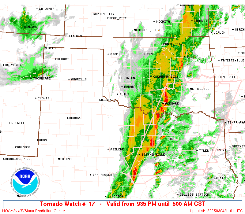
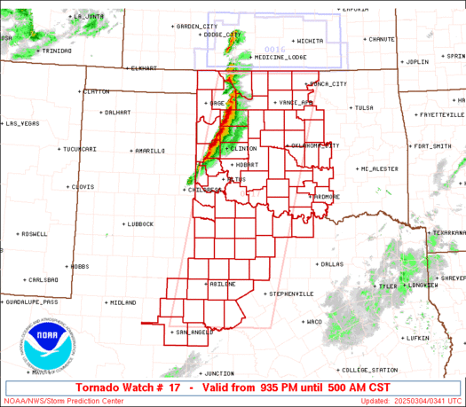
Tornado Watch Number 17
NWS Storm Prediction Center Norman OK
935 PM CST Mon Mar 3 2025
The NWS Storm Prediction Center has issued a
* Tornado Watch for portions of
Western and Central Oklahoma
Western North Texas
* Effective this Monday night and Tuesday morning from 935 PM
until 500 AM CST.
* Primary threats include...
A few tornadoes possible
Scattered damaging wind gusts to 70 mph likely
Scattered large hail events to 1.5 inches in diameter possible
SUMMARY...Severe storms are expected to develop and increase
initially across western Oklahoma into western North Texas, with
tornado potential expected to increase late this evening into the
overnight, with a damaging wind and hail risk as well.
The tornado watch area is approximately along and 75 statute miles
east and west of a line from 35 miles east northeast of Alva OK to
30 miles southwest of Brownwood TX. For a complete depiction of the
watch see the associated watch outline update (WOUS64 KWNS WOU7).
PRECAUTIONARY/PREPAREDNESS ACTIONS...
REMEMBER...A Tornado Watch means conditions are favorable for
tornadoes and severe thunderstorms in and close to the watch
area. Persons in these areas should be on the lookout for
threatening weather conditions and listen for later statements
and possible warnings.
&&
OTHER WATCH INFORMATION...CONTINUE...WW 16...
AVIATION...Tornadoes and a few severe thunderstorms with hail
surface and aloft to 1.5 inches. Extreme turbulence and surface wind
gusts to 60 knots. A few cumulonimbi with maximum tops to 500. Mean
storm motion vector 25025.
...Guyer

   SEL7

   URGENT - IMMEDIATE BROADCAST REQUESTED
   Tornado Watch Number 17
   NWS Storm Prediction Center Norman OK
   935 PM CST Mon Mar 3 2025

   The NWS Storm Prediction Center has issued a

   * Tornado Watch for portions of
     Western and Central Oklahoma
     Western North Texas

   * Effective this Monday night and Tuesday morning from 935 PM
     until 500 AM CST.

   * Primary threats include...
     A few tornadoes possible
     Scattered damaging wind gusts to 70 mph likely
     Scattered large hail events to 1.5 inches in diameter possible

   SUMMARY...Severe storms are expected to develop and increase
   initially across western Oklahoma into western North Texas, with
   tornado potential expected to increase late this evening into the
   overnight, with a damaging wind and hail risk as well.

   The tornado watch area is approximately along and 75 statute miles
   east and west of a line from 35 miles east northeast of Alva OK to
   30 miles southwest of Brownwood TX. For a complete depiction of the
   watch see the associated watch outline update (WOUS64 KWNS WOU7).

   PRECAUTIONARY/PREPAREDNESS ACTIONS...

   REMEMBER...A Tornado Watch means conditions are favorable for
   tornadoes and severe thunderstorms in and close to the watch
   area. Persons in these areas should be on the lookout for
   threatening weather conditions and listen for later statements
   and possible warnings.

   &&

   OTHER WATCH INFORMATION...CONTINUE...WW 16...

   AVIATION...Tornadoes and a few severe thunderstorms with hail
   surface and aloft to 1.5 inches. Extreme turbulence and surface wind
   gusts to 60 knots. A few cumulonimbi with maximum tops to 500. Mean
   storm motion vector 25025.

   ...Guyer
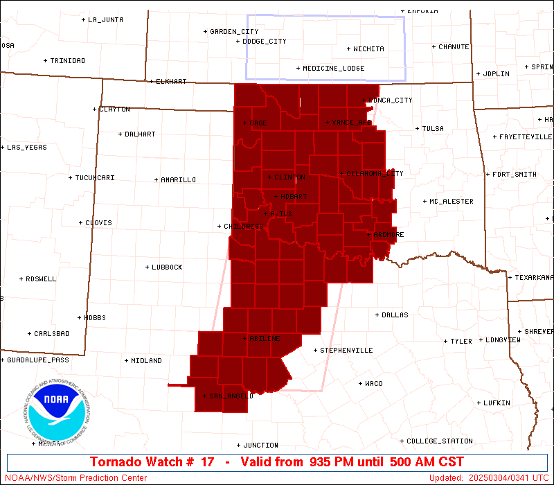
 Note:
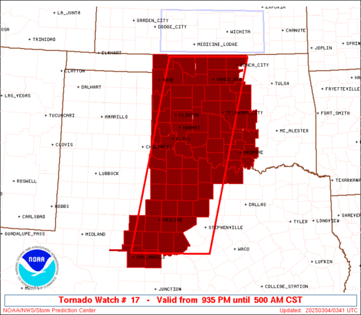
The Aviation Watch (SAW) product is an approximation to the watch area.
The actual watch is depicted by the shaded areas.
Note:
The Aviation Watch (SAW) product is an approximation to the watch area.
The actual watch is depicted by the shaded areas.
   SAW7
   WW 17 TORNADO OK TX 040335Z - 041100Z
   AXIS..75 STATUTE MILES EAST AND WEST OF LINE..
   35ENE AVK/ALVA OK/ - 30SW BWD/BROWNWOOD TX/
   ..AVIATION COORDS.. 65NM E/W /38NNW END - 59E SJT/
   HAIL SURFACE AND ALOFT..1.5 INCHES. WIND GUSTS..60 KNOTS.
   MAX TOPS TO 500. MEAN STORM MOTION VECTOR 25025.

   LAT...LON 36959673 31499804 31490058 36959944

   THIS IS AN APPROXIMATION TO THE WATCH AREA.  FOR A
   COMPLETE DEPICTION OF THE WATCH SEE WOUS64 KWNS
   FOR WOU7.
Watch 17 Status Report Messages:
STATUS REPORT #4 ON WW 17
VALID 041000Z - 041140Z
SEVERE WEATHER THREAT CONTINUES RIGHT OF A LINE FROM 25 NNE JCT
TO 40 WSW BWD TO 40 E ABI TO 40 NW MWL TO 35 S SPS TO 35 SE SPS
TO 30 E SPS TO 25 ESE CHK TO 25 ENE CQB.
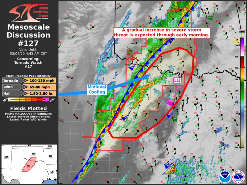
FOR ADDITIONAL INFORMATION SEE MESOSCALE DISCUSSION 127
..JEWELL..03/04/25
ATTN...WFO...OUN...SJT...FWD...
&&
STATUS REPORT FOR WT 17
SEVERE WEATHER THREAT CONTINUES FOR THE FOLLOWING AREAS
OKC019-027-049-067-069-085-087-095-099-123-125-133-137-041140-
OK
. OKLAHOMA COUNTIES INCLUDED ARE
CARTER CLEVELAND GARVIN
JEFFERSON JOHNSTON LOVE
MCCLAIN MARSHALL MURRAY
PONTOTOC POTTAWATOMIE SEMINOLE
STEPHENS
$$
TXC049-077-083-097-133-237-337-363-429-503-041140-
TX
. TEXAS COUNTIES INCLUDED ARE
BROWN CLAY COLEMAN
COOKE EASTLAND JACK
MONTAGUE PALO PINTO STEPHENS
YOUNG
$$
THE WATCH STATUS MESSAGE IS FOR GUIDANCE PURPOSES ONLY. PLEASE
REFER TO WATCH COUNTY NOTIFICATION STATEMENTS FOR OFFICIAL
INFORMATION ON COUNTIES...INDEPENDENT CITIES AND MARINE ZONES
CLEARED FROM SEVERE THUNDERSTORM AND TORNADO WATCHES.
$$
STATUS REPORT #3 ON WW 17
VALID 040700Z - 040840Z
SEVERE WEATHER THREAT CONTINUES RIGHT OF A LINE FROM 55 S CDS TO
40 SE CDS TO 15 E LTS TO 30 WNW CHK TO 25 S END TO 5 WNW PNC TO
35 NW BVO.
FOR ADDITIONAL INFORMATION SEE MESOSCALE DISCUSSION
..JEWELL..03/04/25
ATTN...WFO...OUN...SJT...FWD...
&&
STATUS REPORT FOR WT 17
SEVERE WEATHER THREAT CONTINUES FOR THE FOLLOWING AREAS
OKC015-017-019-027-031-033-049-051-065-067-069-071-073-081-083-
085-087-095-099-103-109-119-123-125-133-137-141-040840-
OK
. OKLAHOMA COUNTIES INCLUDED ARE
CADDO CANADIAN CARTER
CLEVELAND COMANCHE COTTON
GARVIN GRADY JACKSON
JEFFERSON JOHNSTON KAY
KINGFISHER LINCOLN LOGAN
LOVE MCCLAIN MARSHALL
MURRAY NOBLE OKLAHOMA
PAYNE PONTOTOC POTTAWATOMIE
SEMINOLE STEPHENS TILLMAN
$$
TXC009-023-049-059-077-081-083-095-097-133-155-197-207-237-253-
275-337-353-363-399-417-429-441-447-451-485-487-503-040840-
TX
. TEXAS COUNTIES INCLUDED ARE
ARCHER BAYLOR BROWN
CALLAHAN CLAY COKE
COLEMAN CONCHO COOKE
EASTLAND FOARD HARDEMAN
HASKELL JACK JONES
KNOX MONTAGUE NOLAN
PALO PINTO RUNNELS SHACKELFORD
STEPHENS TAYLOR THROCKMORTON
TOM GREEN WICHITA WILBARGER
YOUNG
$$
THE WATCH STATUS MESSAGE IS FOR GUIDANCE PURPOSES ONLY. PLEASE
REFER TO WATCH COUNTY NOTIFICATION STATEMENTS FOR OFFICIAL
INFORMATION ON COUNTIES...INDEPENDENT CITIES AND MARINE ZONES
CLEARED FROM SEVERE THUNDERSTORM AND TORNADO WATCHES.
$$
STATUS REPORT #2 ON WW 17
VALID 040540Z - 040640Z
SEVERE WEATHER THREAT CONTINUES RIGHT OF A LINE FROM 15 SE CDS TO
15 E CSM TO 40 SW END TO 40 NW PNC.
FOR ADDITIONAL INFORMATION SEE MESOSCALE DISCUSSION 126.
..LEITMAN..03/04/25
ATTN...WFO...OUN...SJT...FWD...
&&
STATUS REPORT FOR WT 17
SEVERE WEATHER THREAT CONTINUES FOR THE FOLLOWING AREAS
OKC011-015-017-019-027-031-033-047-049-051-053-055-065-067-069-
071-073-075-081-083-085-087-095-099-103-109-119-123-125-133-137-
141-149-040640-
OK
. OKLAHOMA COUNTIES INCLUDED ARE
BLAINE CADDO CANADIAN
CARTER CLEVELAND COMANCHE
COTTON GARFIELD GARVIN
GRADY GRANT GREER
JACKSON JEFFERSON JOHNSTON
KAY KINGFISHER KIOWA
LINCOLN LOGAN LOVE
MCCLAIN MARSHALL MURRAY
NOBLE OKLAHOMA PAYNE
PONTOTOC POTTAWATOMIE SEMINOLE
STEPHENS TILLMAN WASHITA
$$
TXC009-023-049-059-077-081-083-095-097-133-155-197-207-237-253-
275-337-353-363-399-417-429-441-447-451-485-487-503-040640-
TX
. TEXAS COUNTIES INCLUDED ARE
ARCHER BAYLOR BROWN
CALLAHAN CLAY COKE
COLEMAN CONCHO COOKE
EASTLAND FOARD HARDEMAN
HASKELL JACK JONES
KNOX MONTAGUE NOLAN
PALO PINTO RUNNELS SHACKELFORD
STEPHENS TAYLOR THROCKMORTON
TOM GREEN WICHITA WILBARGER
YOUNG
$$
THE WATCH STATUS MESSAGE IS FOR GUIDANCE PURPOSES ONLY. PLEASE
REFER TO WATCH COUNTY NOTIFICATION STATEMENTS FOR OFFICIAL
INFORMATION ON COUNTIES...INDEPENDENT CITIES AND MARINE ZONES
CLEARED FROM SEVERE THUNDERSTORM AND TORNADO WATCHES.
$$
STATUS REPORT #1 ON WW 17
VALID 040430Z - 040540Z
SEVERE WEATHER THREAT CONTINUES RIGHT OF A LINE FROM 30 NNE CDS
TO 25 NNW CSM TO 5 SSW AVK TO 5 SSE P28.
..LEITMAN..03/04/25
ATTN...WFO...OUN...SJT...FWD...
&&
STATUS REPORT FOR WT 17
SEVERE WEATHER THREAT CONTINUES FOR THE FOLLOWING AREAS
OKC003-011-015-017-019-027-031-033-039-043-047-049-051-053-055-
057-065-067-069-071-073-075-081-083-085-087-093-095-099-103-109-
119-123-125-133-137-141-149-040540-
OK
. OKLAHOMA COUNTIES INCLUDED ARE
ALFALFA BLAINE CADDO
CANADIAN CARTER CLEVELAND
COMANCHE COTTON CUSTER
DEWEY GARFIELD GARVIN
GRADY GRANT GREER
HARMON JACKSON JEFFERSON
JOHNSTON KAY KINGFISHER
KIOWA LINCOLN LOGAN
LOVE MCCLAIN MAJOR
MARSHALL MURRAY NOBLE
OKLAHOMA PAYNE PONTOTOC
POTTAWATOMIE SEMINOLE STEPHENS
TILLMAN WASHITA
$$
TXC009-023-049-059-077-081-083-095-097-133-155-197-207-237-253-
275-337-353-363-399-417-429-441-447-451-485-487-503-040540-
TX
. TEXAS COUNTIES INCLUDED ARE
ARCHER BAYLOR BROWN
CALLAHAN CLAY COKE
COLEMAN CONCHO COOKE
EASTLAND FOARD HARDEMAN
HASKELL JACK JONES
KNOX MONTAGUE NOLAN
PALO PINTO RUNNELS SHACKELFORD
STEPHENS TAYLOR THROCKMORTON
TOM GREEN WICHITA WILBARGER
YOUNG
$$
THE WATCH STATUS MESSAGE IS FOR GUIDANCE PURPOSES ONLY. PLEASE
REFER TO WATCH COUNTY NOTIFICATION STATEMENTS FOR OFFICIAL
INFORMATION ON COUNTIES...INDEPENDENT CITIES AND MARINE ZONES
CLEARED FROM SEVERE THUNDERSTORM AND TORNADO WATCHES.
$$
Note:
Click for Complete Product Text.
Tornadoes
Probability of 2 or more tornadoes
|
Mod (50%)
|
Probability of 1 or more strong (EF2-EF5) tornadoes
|
Low (20%)
|
Wind
Probability of 10 or more severe wind events
|
Mod (60%)
|
Probability of 1 or more wind events > 65 knots
|
Low (20%)
|
Hail
Probability of 10 or more severe hail events
|
Mod (40%)
|
Probability of 1 or more hailstones > 2 inches
|
Low (20%)
|
Combined Severe Hail/Wind
Probability of 6 or more combined severe hail/wind events
|
High (90%)
|
For each watch, probabilities for particular events inside the watch
(listed above in each table) are determined by the issuing forecaster.
The "Low" category contains probability values ranging from less than 2%
to 20% (EF2-EF5 tornadoes), less than 5% to 20% (all other probabilities),
"Moderate" from 30% to 60%, and "High" from 70% to greater than 95%.
High values are bolded and lighter in color to provide awareness of
an increased threat for a particular event.


 @NWSSPC