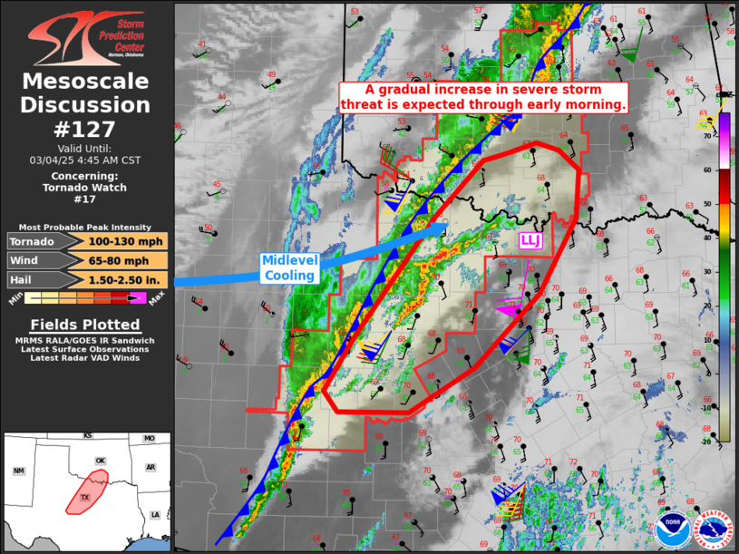
   Mesoscale Discussion 0127
   NWS Storm Prediction Center Norman OK
   0238 AM CST Tue Mar 04 2025

   Areas affected...west-central into northern Texas and south-central
   Oklahoma

   Concerning...Tornado Watch 17...

   Valid 040838Z - 041045Z

   The severe weather threat for Tornado Watch 17 continues.

   SUMMARY...The severe storm threat will likely increase over the next
   several hours, with potential for damaging winds and brief
   tornadoes. Additional parts of northern Texas may need a watch later
   this morning.

   DISCUSSION...A line of storms exists along a developing cold front,
   from central OK across northwest TX and into west-central TX. The
   line of storms has not been particularly strong over OK, however,
   the fast-approaching speed max aloft, along with midlevel cooling,
   is expected to ramp up severe potential across the region over the
   next several hours.

   Additional cells are already developing ahead of the line over
   western parts of North TX, within the warm advection zone where
   lower 60s F dewpoints are streaming north. Pressure falls continue
   as well across the area, with 1-2 mb/hr.

   Recent radar trends suggest the leading midlevel vort is now moving
   into the San Angelo area with intensifying line of storms. This
   feature/wave should then proceed northeastward along the front, with
   various bows producing damaging gusts likely. A few brief tornadoes
   may also occur, as low level shear is quite strong with 0-1 SRH of
   200-300 m2/s2.

   ..Jewell/Smith.. 03/04/2025

   ...Please see www.spc.noaa.gov for graphic product...

   ATTN...WFO...FWD...OUN...SJT...

   LAT...LON   32459977 33919863 34599793 34669762 34809716 34709684
               34479654 33889660 32979713 32099807 31559899 31559999
               31800020 32459977
|


 @NWSSPC