|
| Mesoscale Discussion 126 |
|
< Previous MD Next MD >
|
|
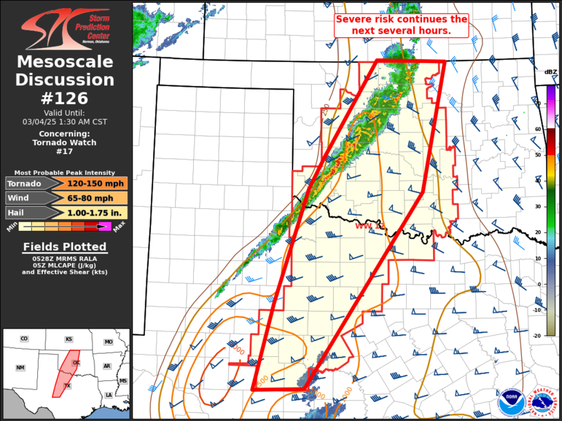
   Mesoscale Discussion 0126
   NWS Storm Prediction Center Norman OK
   1131 PM CST Mon Mar 03 2025

   Areas affected...portions of western/central OK into north/central
   TX

   Concerning...Tornado Watch 17...

   Valid 040531Z - 040730Z

   The severe weather threat for Tornado Watch 17 continues.

   SUMMARY...Severe thunderstorms posing a risk of damaging gusts and a
   few tornadoes will continue to shift east across western/central
   Oklahoma and portions central/northern Texas the next several hours.

   DISCUSSION...A line of convection across western OK continues to
   shift east at around 30-40 mph. These storms have been generally
   been organized given strong vertical shear. However, convection has
   largely remained elevated given modest boundary layer moisture and
   poor low-level lapse rates. Nevertheless, a few severe gusts near 60
   mph have been noted. Furthermore, a few line-embedded cells have
   occasionally exhibited modest low-level rotation. This suggests if
   these storms can become surface-based, the tornado risk would
   increase given very large, favorably curved hodographs as seen in
   region VWP data.

   Convection may intensify with time and southward extent across parts
   of the Red River vicinity as convection moves into somewhat better
   quality moisture later tonight. Trends will be monitored and
   downstream watch issuance may become necessary across parts of
   eastern OK and north/northeast TX in the next few hours.

   ..Leitman.. 03/04/2025

   ...Please see www.spc.noaa.gov for graphic product...

   ATTN...WFO...TSA...ICT...FWD...OUN...SJT...LUB...

   LAT...LON   35279930 37029814 36999661 34659716 31129969 31090077
               32640034 34709964 35279930
|
|
Top/All Mesoscale Discussions/Forecast Products/Home
|
|


 @NWSSPC