 Note:
The expiration time in the watch graphic is amended if the watch is
replaced, cancelled or extended.
Note:
Note:
The expiration time in the watch graphic is amended if the watch is
replaced, cancelled or extended.
Note: Click for
Watch Status Reports.
SEL8
URGENT - IMMEDIATE BROADCAST REQUESTED
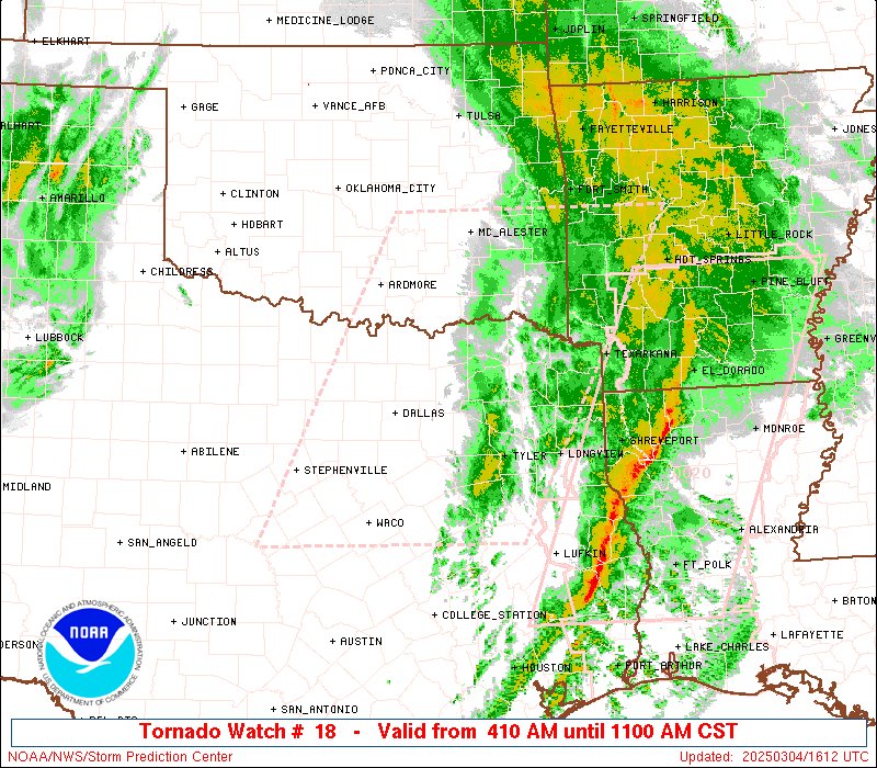
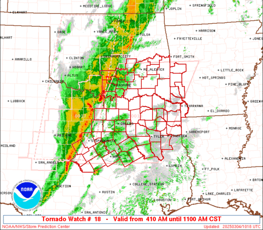
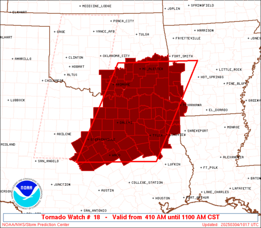
Tornado Watch Number 18
NWS Storm Prediction Center Norman OK
410 AM CST Tue Mar 4 2025
The NWS Storm Prediction Center has issued a
* Tornado Watch for portions of
Southwest Arkansas
Southern and Southeast Oklahoma
Central into North and Northeast Texas
* Effective this Tuesday morning from 410 AM until 1100 AM CST.
* Primary threats include...
A few tornadoes possible
Scattered damaging winds likely with isolated significant gusts
to 75 mph possible
Isolated large hail events to 1.5 inches in diameter possible
SUMMARY...A mature squall line will continue to quickly move
eastward across the Watch area this morning. The potential for
severe gusts (60-75 mph) and a tornado risk will accompany the
squall line. A possibility also exists for a few storms to develop
ahead of the squall line and a threat for tornadoes and large hail
may occur with this potential activity.
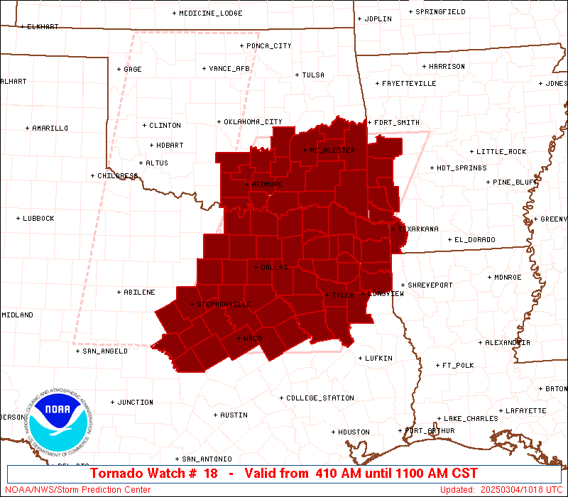
The tornado watch area is approximately along and 105 statute miles
east and west of a line from 20 miles west northwest of Poteau OK to
25 miles southeast of Waco TX. For a complete depiction of the watch
see the associated watch outline update (WOUS64 KWNS WOU8).
PRECAUTIONARY/PREPAREDNESS ACTIONS...
REMEMBER...A Tornado Watch means conditions are favorable for
tornadoes and severe thunderstorms in and close to the watch
area. Persons in these areas should be on the lookout for
threatening weather conditions and listen for later statements
and possible warnings.
&&
OTHER WATCH INFORMATION...CONTINUE...WW 17...
AVIATION...Tornadoes and a few severe thunderstorms with hail
surface and aloft to 1.5 inches. Extreme turbulence and surface wind
gusts to 65 knots. A few cumulonimbi with maximum tops to 450. Mean
storm motion vector 23045.
...Smith
 Note:
The Aviation Watch (SAW) product is an approximation to the watch area.
The actual watch is depicted by the shaded areas.
Note:
The Aviation Watch (SAW) product is an approximation to the watch area.
The actual watch is depicted by the shaded areas.
   SAW8
   WW 18 TORNADO AR OK TX 041010Z - 041700Z
   AXIS..105 STATUTE MILES EAST AND WEST OF LINE..
   20WNW RKR/POTEAU OK/ - 25SE ACT/WACO TX/
   ..AVIATION COORDS.. 90NM E/W /36WSW FSM - 25SE ACT/
   HAIL SURFACE AND ALOFT..1.5 INCHES. WIND GUSTS..65 KNOTS.
   MAX TOPS TO 450. MEAN STORM MOTION VECTOR 23045.

   LAT...LON 35129309 31359515 31359871 35129680

   THIS IS AN APPROXIMATION TO THE WATCH AREA.  FOR A
   COMPLETE DEPICTION OF THE WATCH SEE WOUS64 KWNS
   FOR WOU8.
Watch 18 Status Report Messages:
STATUS REPORT #3 ON WW 18

VALID 041440Z - 041540Z

SEVERE WEATHER THREAT CONTINUES RIGHT OF A LINE FROM 45 NNW UTS
TO 30 W TXK TO 30 NNW DEQ TO 20 WNW FSM.

..SUPINIE..03/04/25

ATTN...WFO...SHV...LZK...OUN...TSA...FWD...

&&

STATUS REPORT FOR WT 18

SEVERE WEATHER THREAT CONTINUES FOR THE FOLLOWING AREAS

ARC061-081-091-113-127-133-041540-

AR
.    ARKANSAS COUNTIES INCLUDED ARE

HOWARD		     LITTLE RIVER	 MILLER
POLK		     SCOTT		 SEVIER
$$


OKC001-079-135-041540-

OK
.    OKLAHOMA COUNTIES INCLUDED ARE

ADAIR		     LE FLORE		 SEQUOYAH
$$


TXC037-067-073-183-203-315-343-401-459-041540-

TX
.    TEXAS COUNTIES INCLUDED ARE

BOWIE		     CASS		 CHEROKEE
GREGG		     HARRISON		 MARION
MORRIS		     RUSK		 UPSHUR
$$


THE WATCH STATUS MESSAGE IS FOR GUIDANCE PURPOSES ONLY.  PLEASE
REFER TO WATCH COUNTY NOTIFICATION STATEMENTS FOR OFFICIAL
INFORMATION ON COUNTIES...INDEPENDENT CITIES AND MARINE ZONES
CLEARED FROM SEVERE THUNDERSTORM AND TORNADO WATCHES.
$$

STATUS REPORT #2 ON WW 18

VALID 041355Z - 041440Z

SEVERE WEATHER THREAT CONTINUES RIGHT OF A LINE FROM 45 N CLL TO
30 SW TYR TO 40 NNE TYR TO 25 E PRX TO 40 SW RKR TO 30 SSE MKO.

..BENTLEY..03/04/25

ATTN...WFO...SHV...LZK...OUN...TSA...FWD...

&&

STATUS REPORT FOR WT 18

SEVERE WEATHER THREAT CONTINUES FOR THE FOLLOWING AREAS

ARC061-081-091-113-127-133-041440-

AR
.    ARKANSAS COUNTIES INCLUDED ARE

HOWARD		     LITTLE RIVER	 MILLER
POLK		     SCOTT		 SEVIER
$$


OKC001-021-079-089-135-041440-

OK
.    OKLAHOMA COUNTIES INCLUDED ARE

ADAIR		     CHEROKEE		 LE FLORE
MCCURTAIN	     SEQUOYAH
$$


TXC001-037-063-067-073-159-161-183-203-315-343-387-401-423-449-
459-041440-

TX
.    TEXAS COUNTIES INCLUDED ARE

ANDERSON	     BOWIE		 CAMP
CASS		     CHEROKEE		 FRANKLIN
FREESTONE	     GREGG		 HARRISON
MARION		     MORRIS		 RED RIVER
RUSK		     SMITH		 TITUS
UPSHUR
$$


THE WATCH STATUS MESSAGE IS FOR GUIDANCE PURPOSES ONLY.  PLEASE
REFER TO WATCH COUNTY NOTIFICATION STATEMENTS FOR OFFICIAL
INFORMATION ON COUNTIES...INDEPENDENT CITIES AND MARINE ZONES
CLEARED FROM SEVERE THUNDERSTORM AND TORNADO WATCHES.
$$

STATUS REPORT #1 ON WW 18

VALID 041245Z - 041340Z

SEVERE WEATHER THREAT CONTINUES RIGHT OF A LINE FROM 15 ENE TPL
TO 25 NE ACT TO 15 NNW CRS TO 40 E DAL TO 40 SW PRX TO 25 W PRX
TO 30 S MLC TO 25 WSW MKO.

..JEWELL..03/04/25

ATTN...WFO...SHV...LZK...OUN...TSA...FWD...

&&

STATUS REPORT FOR WT 18

SEVERE WEATHER THREAT CONTINUES FOR THE FOLLOWING AREAS

ARC061-081-091-113-127-133-041340-

AR
.    ARKANSAS COUNTIES INCLUDED ARE

HOWARD		     LITTLE RIVER	 MILLER
POLK		     SCOTT		 SEVIER
$$


OKC001-021-023-061-077-079-089-091-101-121-127-135-145-041340-

OK
.    OKLAHOMA COUNTIES INCLUDED ARE

ADAIR		     CHEROKEE		 CHOCTAW
HASKELL 	     LATIMER		 LE FLORE
MCCURTAIN	     MCINTOSH		 MUSKOGEE
PITTSBURG	     PUSHMATAHA 	 SEQUOYAH
WAGONER
$$


TXC001-037-063-067-073-119-159-161-183-203-213-223-231-257-277-
293-315-343-349-379-387-401-423-449-459-467-499-041340-

TX
.    TEXAS COUNTIES INCLUDED ARE

ANDERSON	     BOWIE		 CAMP
CASS		     CHEROKEE		 DELTA
FRANKLIN	     FREESTONE		 GREGG
HARRISON	     HENDERSON		 HOPKINS
HUNT		     KAUFMAN		 LAMAR
LIMESTONE	     MARION		 MORRIS
NAVARRO 	     RAINS		 RED RIVER
RUSK		     SMITH		 TITUS
UPSHUR		     VAN ZANDT		 WOOD
$$


THE WATCH STATUS MESSAGE IS FOR GUIDANCE PURPOSES ONLY.  PLEASE
REFER TO WATCH COUNTY NOTIFICATION STATEMENTS FOR OFFICIAL
INFORMATION ON COUNTIES...INDEPENDENT CITIES AND MARINE ZONES
CLEARED FROM SEVERE THUNDERSTORM AND TORNADO WATCHES.
$$
Note:
Click for Complete Product Text.
Tornadoes
Probability of 2 or more tornadoes
|
Mod (50%)
|
Probability of 1 or more strong (EF2-EF5) tornadoes
|
Low (20%)
|
Wind
Probability of 10 or more severe wind events
|
Mod (60%)
|
Probability of 1 or more wind events > 65 knots
|
Mod (30%)
|
Hail
Probability of 10 or more severe hail events
|
Low (20%)
|
Probability of 1 or more hailstones > 2 inches
|
Low (10%)
|
Combined Severe Hail/Wind
Probability of 6 or more combined severe hail/wind events
|
High (90%)
|
For each watch, probabilities for particular events inside the watch
(listed above in each table) are determined by the issuing forecaster.
The "Low" category contains probability values ranging from less than 2%
to 20% (EF2-EF5 tornadoes), less than 5% to 20% (all other probabilities),
"Moderate" from 30% to 60%, and "High" from 70% to greater than 95%.
High values are bolded and lighter in color to provide awareness of
an increased threat for a particular event.


 @NWSSPC