Note:
The expiration time in the watch graphic is amended if the watch is
replaced, cancelled or extended.
Note:
Note:
The expiration time in the watch graphic is amended if the watch is
replaced, cancelled or extended.
Note: Click for
Watch Status Reports.
SEL9
URGENT - IMMEDIATE BROADCAST REQUESTED
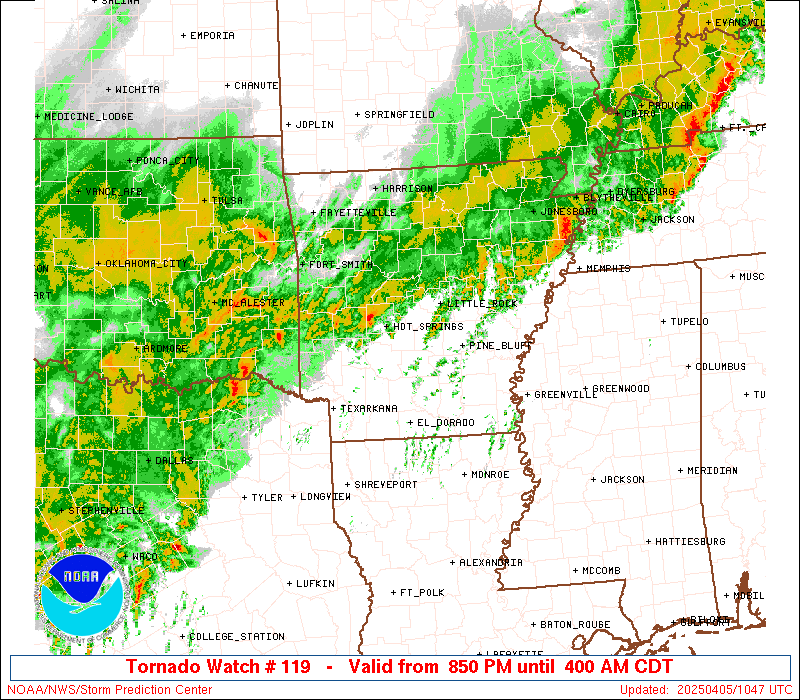
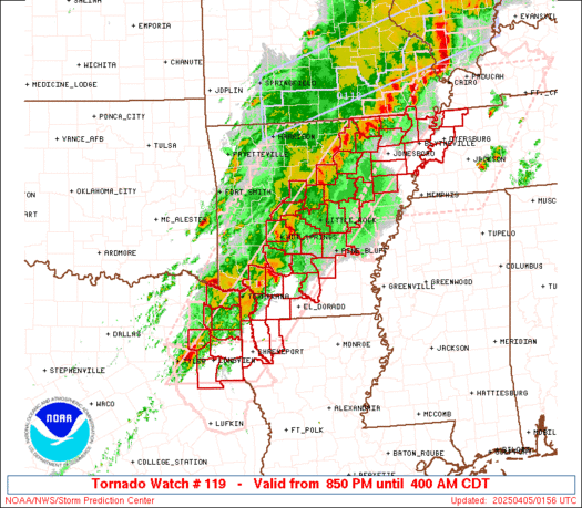
Tornado Watch Number 119
NWS Storm Prediction Center Norman OK
850 PM CDT Fri Apr 4 2025
The NWS Storm Prediction Center has issued a
* Tornado Watch for portions of
Arkansas
Northwest Louisiana
Missouri Bootheel
Northwest Tennessee
Northeast Texas
* Effective this Friday night and Saturday morning from 850 PM
until 400 AM CDT.
* Primary threats include...
A few tornadoes and a couple intense tornadoes likely
Scattered damaging wind gusts to 70 mph likely
Scattered large hail and isolated very large hail events to 2
inches in diameter possible
SUMMARY...A line of occasionally intense thunderstorms with embedded
supercells will track slowly eastward across the watch area
overnight. Favorable instability and shear profiles will maintain a
risk of a few tornadoes, along with damaging winds and large hail.
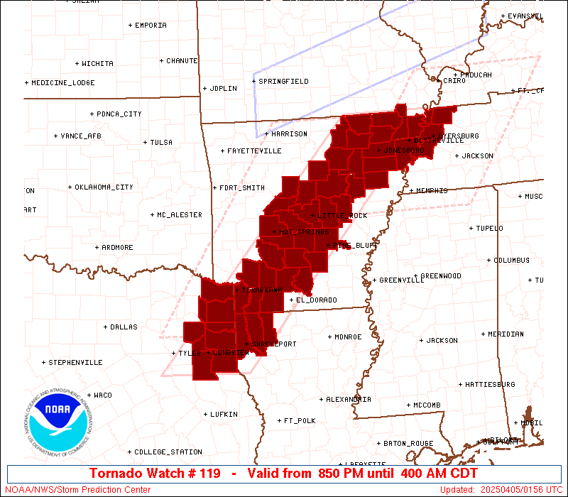
The tornado watch area is approximately along and 55 statute miles
east and west of a line from 30 miles south of Longview TX to 40
miles northeast of Walnut Ridge AR. For a complete depiction of the
watch see the associated watch outline update (WOUS64 KWNS WOU9).
PRECAUTIONARY/PREPAREDNESS ACTIONS...
REMEMBER...A Tornado Watch means conditions are favorable for
tornadoes and severe thunderstorms in and close to the watch
area. Persons in these areas should be on the lookout for
threatening weather conditions and listen for later statements
and possible warnings.
&&
OTHER WATCH INFORMATION...CONTINUE...WW 113...WW 115...WW 118...
AVIATION...Tornadoes and a few severe thunderstorms with hail
surface and aloft to 2 inches. Extreme turbulence and surface wind
gusts to 60 knots. A few cumulonimbi with maximum tops to 500. Mean
storm motion vector 23035.
...Hart
   SEL9

   URGENT - IMMEDIATE BROADCAST REQUESTED
   Tornado Watch Number 119
   NWS Storm Prediction Center Norman OK
   850 PM CDT Fri Apr 4 2025

   The NWS Storm Prediction Center has issued a

   * Tornado Watch for portions of
     Arkansas
     Northwest Louisiana
     Missouri Bootheel
     Northwest Tennessee
     Northeast Texas

   * Effective this Friday night and Saturday morning from 850 PM
     until 400 AM CDT.

   * Primary threats include...
     A few tornadoes and a couple intense tornadoes likely
     Scattered damaging wind gusts to 70 mph likely
     Scattered large hail and isolated very large hail events to 2
       inches in diameter possible

   SUMMARY...A line of occasionally intense thunderstorms with embedded
   supercells will track slowly eastward across the watch area
   overnight.  Favorable instability and shear profiles will maintain a
   risk of a few tornadoes, along with damaging winds and large hail.

   The tornado watch area is approximately along and 55 statute miles
   east and west of a line from 30 miles south of Longview TX to 40
   miles northeast of Walnut Ridge AR. For a complete depiction of the
   watch see the associated watch outline update (WOUS64 KWNS WOU9).

   PRECAUTIONARY/PREPAREDNESS ACTIONS...

   REMEMBER...A Tornado Watch means conditions are favorable for
   tornadoes and severe thunderstorms in and close to the watch
   area. Persons in these areas should be on the lookout for
   threatening weather conditions and listen for later statements
   and possible warnings.

   &&

   OTHER WATCH INFORMATION...CONTINUE...WW 113...WW 115...WW 118...

   AVIATION...Tornadoes and a few severe thunderstorms with hail
   surface and aloft to 2 inches. Extreme turbulence and surface wind
   gusts to 60 knots. A few cumulonimbi with maximum tops to 500. Mean
   storm motion vector 23035.

   ...Hart
 Note:
The Aviation Watch (SAW) product is an approximation to the watch area.
The actual watch is depicted by the shaded areas.
Note:
The Aviation Watch (SAW) product is an approximation to the watch area.
The actual watch is depicted by the shaded areas.
SAW9
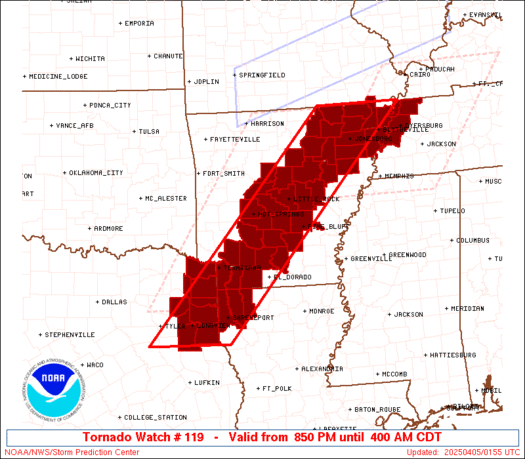
WW 119 TORNADO AR LA MO TN TX 050150Z - 050900Z
AXIS..55 STATUTE MILES EAST AND WEST OF LINE..
30S GGG/LONGVIEW TX/ - 40NE ARG/WALNUT RIDGE AR/
..AVIATION COORDS.. 50NM E/W /29S GGG - 36NE ARG/
HAIL SURFACE AND ALOFT..2 INCHES. WIND GUSTS..60 KNOTS.
MAX TOPS TO 500. MEAN STORM MOTION VECTOR 23035.
LAT...LON 31949566 36539141 36538943 31949378
THIS IS AN APPROXIMATION TO THE WATCH AREA. FOR A
COMPLETE DEPICTION OF THE WATCH SEE WOUS64 KWNS
FOR WOU9.
Watch 119 Status Report Messages:
STATUS REPORT #6 ON WW 119
VALID 050850Z - 050940Z
SEVERE WEATHER THREAT CONTINUES RIGHT OF A LINE FROM 30 S JBR TO
30 SSW JBR TO 40 N DYR.
..KERR..04/05/25
ATTN...WFO...LZK...MEG...SHV...
&&
STATUS REPORT FOR WT 119
SEVERE WEATHER THREAT CONTINUES FOR THE FOLLOWING AREAS
ARC093-050940-
AR
. ARKANSAS COUNTIES INCLUDED ARE
MISSISSIPPI
$$
MOC155-050940-
MO
. MISSOURI COUNTIES INCLUDED ARE
PEMISCOT
$$
TNC005-017-033-045-053-075-079-095-097-131-167-183-050940-
TN
. TENNESSEE COUNTIES INCLUDED ARE
BENTON CARROLL CROCKETT
DYER GIBSON HAYWOOD
HENRY LAKE LAUDERDALE
OBION TIPTON WEAKLEY
$$
THE WATCH STATUS MESSAGE IS FOR GUIDANCE PURPOSES ONLY. PLEASE
REFER TO WATCH COUNTY NOTIFICATION STATEMENTS FOR OFFICIAL
INFORMATION ON COUNTIES...INDEPENDENT CITIES AND MARINE ZONES
CLEARED FROM SEVERE THUNDERSTORM AND TORNADO WATCHES.
$$
STATUS REPORT #5 ON WW 119
VALID 050735Z - 050840Z
SEVERE WEATHER THREAT CONTINUES RIGHT OF A LINE FROM 35 SSW TYR
TO 25 SSW HOT TO 20 SW LIT TO 40 ESE POF.
..KERR..04/05/25
ATTN...WFO...LZK...MEG...SHV...
&&
STATUS REPORT FOR WT 119
SEVERE WEATHER THREAT CONTINUES FOR THE FOLLOWING AREAS
ARC013-019-021-025-027-031-037-039-053-055-059-069-073-093-099-
103-111-050840-
AR
. ARKANSAS COUNTIES INCLUDED ARE
CALHOUN CLARK CLAY
CLEVELAND COLUMBIA CRAIGHEAD
CROSS DALLAS GRANT
GREENE HOT SPRING JEFFERSON
LAFAYETTE MISSISSIPPI NEVADA
OUACHITA POINSETT
$$
LAC015-017-119-050840-
LA
. LOUISIANA PARISHES INCLUDED ARE
BOSSIER CADDO WEBSTER
$$
MOC069-155-050840-
MO
. MISSOURI COUNTIES INCLUDED ARE
DUNKLIN PEMISCOT
$$
TNC045-095-097-131-050840-
TN
. TENNESSEE COUNTIES INCLUDED ARE
DYER LAKE LAUDERDALE
OBION
$$
TXC203-315-365-401-050840-
TX
. TEXAS COUNTIES INCLUDED ARE
HARRISON MARION PANOLA
RUSK
$$
THE WATCH STATUS MESSAGE IS FOR GUIDANCE PURPOSES ONLY. PLEASE
REFER TO WATCH COUNTY NOTIFICATION STATEMENTS FOR OFFICIAL
INFORMATION ON COUNTIES...INDEPENDENT CITIES AND MARINE ZONES
CLEARED FROM SEVERE THUNDERSTORM AND TORNADO WATCHES.
$$
STATUS REPORT #4 ON WW 119
VALID 050640Z - 050740Z
SEVERE WEATHER THREAT CONTINUES RIGHT OF A LINE FROM 30 SSW TYR
TO 25 SSW HOT TO 25 SW LIT TO 25 NE JBR TO 40 ESE POF.
..KERR..04/05/25
ATTN...WFO...LZK...MEG...SHV...
&&
STATUS REPORT FOR WT 119
SEVERE WEATHER THREAT CONTINUES FOR THE FOLLOWING AREAS
ARC013-019-021-025-027-031-037-039-053-055-057-059-067-069-073-
085-091-093-099-103-111-117-145-147-050740-
AR
. ARKANSAS COUNTIES INCLUDED ARE
CALHOUN CLARK CLAY
CLEVELAND COLUMBIA CRAIGHEAD
CROSS DALLAS GRANT
GREENE HEMPSTEAD HOT SPRING
JACKSON JEFFERSON LAFAYETTE
LONOKE MILLER MISSISSIPPI
NEVADA OUACHITA POINSETT
PRAIRIE WHITE WOODRUFF
$$
LAC015-017-119-050740-
LA
. LOUISIANA PARISHES INCLUDED ARE
BOSSIER CADDO WEBSTER
$$
MOC069-155-050740-
MO
. MISSOURI COUNTIES INCLUDED ARE
DUNKLIN PEMISCOT
$$
TNC045-095-097-131-050740-
TN
. TENNESSEE COUNTIES INCLUDED ARE
DYER LAKE LAUDERDALE
OBION
$$
TXC067-183-203-315-365-401-050740-
TX
. TEXAS COUNTIES INCLUDED ARE
CASS GREGG HARRISON
MARION PANOLA RUSK
$$
THE WATCH STATUS MESSAGE IS FOR GUIDANCE PURPOSES ONLY. PLEASE
REFER TO WATCH COUNTY NOTIFICATION STATEMENTS FOR OFFICIAL
INFORMATION ON COUNTIES...INDEPENDENT CITIES AND MARINE ZONES
CLEARED FROM SEVERE THUNDERSTORM AND TORNADO WATCHES.
$$
STATUS REPORT #3 ON WW 119
VALID 050535Z - 050640Z
SEVERE WEATHER THREAT CONTINUES RIGHT OF A LINE FROM 30 SSW TYR
TO 25 SSW HOT TO 30 E HOT TO 30 ESE BVX TO 20 NNE JBR TO 30 ESE
POF.
..KERR..04/05/25
ATTN...WFO...LZK...MEG...SHV...
&&
STATUS REPORT FOR WT 119
SEVERE WEATHER THREAT CONTINUES FOR THE FOLLOWING AREAS
ARC013-019-021-025-027-031-037-039-053-055-057-059-067-069-073-
085-091-093-099-103-111-117-145-147-050640-
AR
. ARKANSAS COUNTIES INCLUDED ARE
CALHOUN CLARK CLAY
CLEVELAND COLUMBIA CRAIGHEAD
CROSS DALLAS GRANT
GREENE HEMPSTEAD HOT SPRING
JACKSON JEFFERSON LAFAYETTE
LONOKE MILLER MISSISSIPPI
NEVADA OUACHITA POINSETT
PRAIRIE WHITE WOODRUFF
$$
LAC015-017-119-050640-
LA
. LOUISIANA PARISHES INCLUDED ARE
BOSSIER CADDO WEBSTER
$$
MOC069-155-050640-
MO
. MISSOURI COUNTIES INCLUDED ARE
DUNKLIN PEMISCOT
$$
TNC045-095-097-131-050640-
TN
. TENNESSEE COUNTIES INCLUDED ARE
DYER LAKE LAUDERDALE
OBION
$$
TXC067-183-203-315-365-401-050640-
TX
. TEXAS COUNTIES INCLUDED ARE
CASS GREGG HARRISON
MARION PANOLA RUSK
$$
THE WATCH STATUS MESSAGE IS FOR GUIDANCE PURPOSES ONLY. PLEASE
REFER TO WATCH COUNTY NOTIFICATION STATEMENTS FOR OFFICIAL
INFORMATION ON COUNTIES...INDEPENDENT CITIES AND MARINE ZONES
CLEARED FROM SEVERE THUNDERSTORM AND TORNADO WATCHES.
$$
STATUS REPORT #2 ON WW 119
VALID 050445Z - 050540Z
SEVERE WEATHER THREAT CONTINUES RIGHT OF A LINE FROM 35 E DEQ TO
25 NNW LIT TO 5 W ARG TO 20 SSE POF.
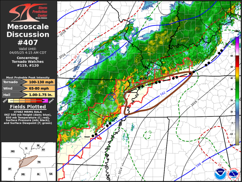
FOR ADDITIONAL INFORMATION SEE MESOSCALE DISCUSSION 404
..GUYER..04/05/25
ATTN...WFO...LZK...MEG...SHV...
&&
STATUS REPORT FOR WT 119
SEVERE WEATHER THREAT CONTINUES FOR THE FOLLOWING AREAS
ARC013-019-021-025-027-031-037-039-045-051-053-055-057-059-063-
067-069-073-075-085-091-093-099-103-111-117-119-125-145-147-
050540-
AR
. ARKANSAS COUNTIES INCLUDED ARE
CALHOUN CLARK CLAY
CLEVELAND COLUMBIA CRAIGHEAD
CROSS DALLAS FAULKNER
GARLAND GRANT GREENE
HEMPSTEAD HOT SPRING INDEPENDENCE
JACKSON JEFFERSON LAFAYETTE
LAWRENCE LONOKE MILLER
MISSISSIPPI NEVADA OUACHITA
POINSETT PRAIRIE PULASKI
SALINE WHITE WOODRUFF
$$
LAC015-017-119-050540-
LA
. LOUISIANA PARISHES INCLUDED ARE
BOSSIER CADDO WEBSTER
$$
MOC069-155-050540-
MO
. MISSOURI COUNTIES INCLUDED ARE
DUNKLIN PEMISCOT
$$
TNC045-095-097-131-050540-
TN
. TENNESSEE COUNTIES INCLUDED ARE
DYER LAKE LAUDERDALE
OBION
$$
TXC037-067-183-203-315-343-365-401-459-050540-
TX
. TEXAS COUNTIES INCLUDED ARE
BOWIE CASS GREGG
HARRISON MARION MORRIS
PANOLA RUSK UPSHUR
$$
THE WATCH STATUS MESSAGE IS FOR GUIDANCE PURPOSES ONLY. PLEASE
REFER TO WATCH COUNTY NOTIFICATION STATEMENTS FOR OFFICIAL
INFORMATION ON COUNTIES...INDEPENDENT CITIES AND MARINE ZONES
CLEARED FROM SEVERE THUNDERSTORM AND TORNADO WATCHES.
$$
STATUS REPORT #1 ON WW 119
VALID 050350Z - 050440Z
THE SEVERE WEATHER THREAT CONTINUES ACROSS THE ENTIRE WATCH AREA.
..GUYER..04/05/25
ATTN...WFO...LZK...MEG...SHV...
&&
STATUS REPORT FOR WT 119
SEVERE WEATHER THREAT CONTINUES FOR THE FOLLOWING AREAS
ARC013-019-021-023-025-027-029-031-037-039-045-051-053-055-057-
059-063-067-069-073-075-085-091-093-099-103-105-111-117-119-121-
125-135-145-147-050440-
AR
. ARKANSAS COUNTIES INCLUDED ARE
CALHOUN CLARK CLAY
CLEBURNE CLEVELAND COLUMBIA
CONWAY CRAIGHEAD CROSS
DALLAS FAULKNER GARLAND
GRANT GREENE HEMPSTEAD
HOT SPRING INDEPENDENCE JACKSON
JEFFERSON LAFAYETTE LAWRENCE
LONOKE MILLER MISSISSIPPI
NEVADA OUACHITA PERRY
POINSETT PRAIRIE PULASKI
RANDOLPH SALINE SHARP
WHITE WOODRUFF
$$
LAC015-017-119-050440-
LA
. LOUISIANA PARISHES INCLUDED ARE
BOSSIER CADDO WEBSTER
$$
MOC069-155-050440-
MO
. MISSOURI COUNTIES INCLUDED ARE
DUNKLIN PEMISCOT
$$
TNC045-095-097-131-050440-
TN
. TENNESSEE COUNTIES INCLUDED ARE
DYER LAKE LAUDERDALE
OBION
$$
TXC037-067-183-203-315-343-365-401-459-050440-
TX
. TEXAS COUNTIES INCLUDED ARE
BOWIE CASS GREGG
HARRISON MARION MORRIS
PANOLA RUSK UPSHUR
$$
THE WATCH STATUS MESSAGE IS FOR GUIDANCE PURPOSES ONLY. PLEASE
REFER TO WATCH COUNTY NOTIFICATION STATEMENTS FOR OFFICIAL
INFORMATION ON COUNTIES...INDEPENDENT CITIES AND MARINE ZONES
CLEARED FROM SEVERE THUNDERSTORM AND TORNADO WATCHES.
$$
Note:
Click for Complete Product Text.
Tornadoes
Probability of 2 or more tornadoes
|
High (70%)
|
Probability of 1 or more strong (EF2-EF5) tornadoes
|
Mod (60%)
|
Wind
Probability of 10 or more severe wind events
|
Mod (60%)
|
Probability of 1 or more wind events > 65 knots
|
Low (20%)
|
Hail
Probability of 10 or more severe hail events
|
Mod (50%)
|
Probability of 1 or more hailstones > 2 inches
|
Mod (50%)
|
Combined Severe Hail/Wind
Probability of 6 or more combined severe hail/wind events
|
High (90%)
|
For each watch, probabilities for particular events inside the watch
(listed above in each table) are determined by the issuing forecaster.
The "Low" category contains probability values ranging from less than 2%
to 20% (EF2-EF5 tornadoes), less than 5% to 20% (all other probabilities),
"Moderate" from 30% to 60%, and "High" from 70% to greater than 95%.
High values are bolded and lighter in color to provide awareness of
an increased threat for a particular event.


 @NWSSPC