|
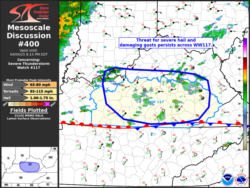
| Mesoscale Discussion 400 |
|
[an error occurred while processing this directive]
|
|
   Mesoscale Discussion 0400
   NWS Storm Prediction Center Norman OK
   0616 PM CDT Fri Apr 04 2025

   Areas affected...Portions of eastern Kentucky

   Concerning...Severe Thunderstorm Watch 117...

   Valid 042316Z - 050015Z

   The severe weather threat for Severe Thunderstorm Watch 117
   continues.

   SUMMARY...Threat for severe hail and damaging gusts continues across
   severe thunderstorm Watch 117, though the threat is expected to
   diurnally wane.

   DISCUSSION...Scattered storms are ongoing north of the synoptic
   stationary boundary. Boundary-layer flow has remained relatively
   weak with neutral height tendencies leading to weak forcing. Despite
   this, relatively steep lapse rates and deep convective profiles
   continue to be supportive of a hail threat. Additionally, some drier
   surface air, particularly with eastern extent, may provide some
   negative buoyancy for some weak downbursts that may produce damaging
   gusts. However, recent convective trends have been to weaken the
   storms with the loss of diurnal heating, and storms should continue
   to wane in both coverage and intensity.

   ..Supinie.. 04/04/2025

   ...Please see www.spc.noaa.gov for graphic product...

   ATTN...WFO...JKL...LMK...

   LAT...LON   38188565 38128420 38058353 37878306 37528300 37148304
               36808340 36718395 36688504 36818596 37228656 37778669
               38128662 38228629 38188565

   MOST PROBABLE PEAK TORNADO INTENSITY...85-115 MPH
   MOST PROBABLE PEAK WIND GUST...65-80 MPH
   MOST PROBABLE PEAK HAIL SIZE...1.00-1.75 IN
|
|
Top/All Mesoscale Discussions/Forecast Products/Home
|
|


 @NWSSPC