 Note:
The expiration time in the watch graphic is amended if the watch is
replaced, cancelled or extended.
Note:
Note:
The expiration time in the watch graphic is amended if the watch is
replaced, cancelled or extended.
Note: Click for
Watch Status Reports.
SEL2
URGENT - IMMEDIATE BROADCAST REQUESTED
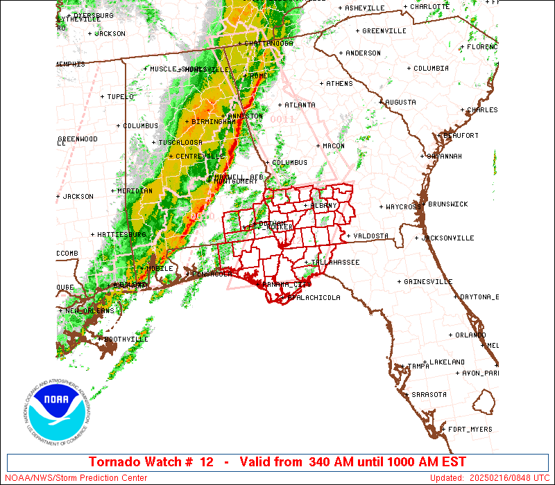
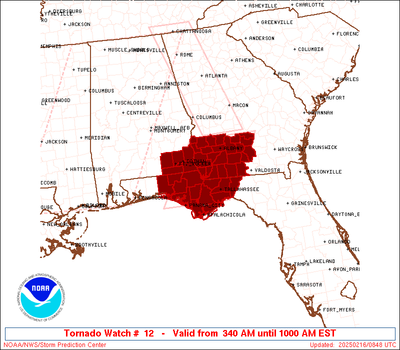
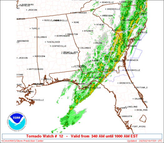
Tornado Watch Number 12
NWS Storm Prediction Center Norman OK
340 AM EST Sun Feb 16 2025
The NWS Storm Prediction Center has issued a
* Tornado Watch for portions of
Southeast Alabama
The Florida Panhandle
Southwest Georgia
* Effective this Sunday morning from 340 AM until 1000 AM EST.
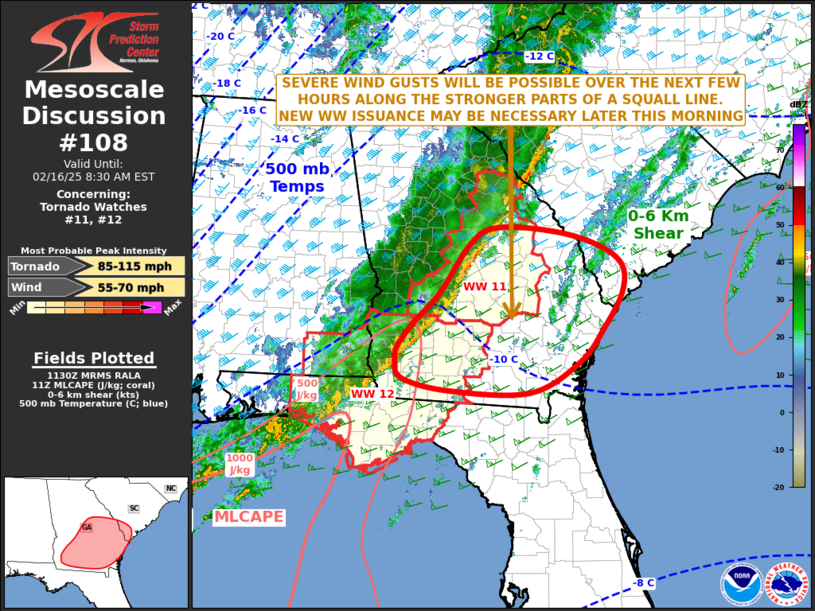
* Primary threats include...
A couple tornadoes possible
Scattered damaging wind gusts to 70 mph possible
SUMMARY...A line of thunderstorms should continue to pose a threat
for scattered damaging winds up to 55-70 mph as it moves eastward
this morning. A couple of line-embedded tornadoes may also occur.
The tornado watch area is approximately along and 65 statute miles
east and west of a line from 25 miles north northeast of Albany GA
to 30 miles east southeast of Panama City FL. For a complete
depiction of the watch see the associated watch outline update
(WOUS64 KWNS WOU2).
PRECAUTIONARY/PREPAREDNESS ACTIONS...
REMEMBER...A Tornado Watch means conditions are favorable for
tornadoes and severe thunderstorms in and close to the watch
area. Persons in these areas should be on the lookout for
threatening weather conditions and listen for later statements
and possible warnings.
&&
OTHER WATCH INFORMATION...CONTINUE...WW 10...WW 11...
AVIATION...Tornadoes and a few severe thunderstorms with hail
surface and aloft to 1 inch. Extreme turbulence and surface wind
gusts to 60 knots. A few cumulonimbi with maximum tops to 450. Mean
storm motion vector 27040.
...Gleason
 Note:
The Aviation Watch (SAW) product is an approximation to the watch area.
The actual watch is depicted by the shaded areas.
Note:
The Aviation Watch (SAW) product is an approximation to the watch area.
The actual watch is depicted by the shaded areas.
   SAW2
   WW 12 TORNADO AL FL GA 160840Z - 161500Z
   AXIS..65 STATUTE MILES EAST AND WEST OF LINE..
   25NNE ABY/ALBANY GA/ - 30ESE PFN/PANAMA CITY FL/
   ..AVIATION COORDS.. 55NM E/W /18NE PZD - 53SW TLH/
   HAIL SURFACE AND ALOFT..1 INCH. WIND GUSTS..60 KNOTS.
   MAX TOPS TO 450. MEAN STORM MOTION VECTOR 27040.

   LAT...LON 31868293 30058413 30058630 31868514

   THIS IS AN APPROXIMATION TO THE WATCH AREA.  FOR A
   COMPLETE DEPICTION OF THE WATCH SEE WOUS64 KWNS
   FOR WOU2.
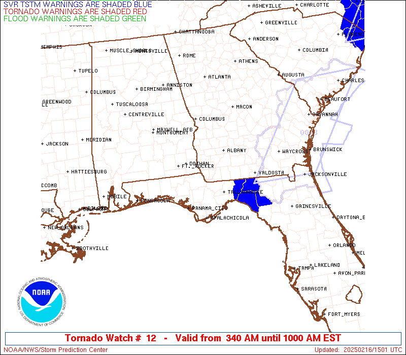
Watch 12 Status Report Messages:
STATUS REPORT #5 ON WW 12

VALID 161425Z - 161500Z

SEVERE WEATHER THREAT CONTINUES RIGHT OF A LINE FROM 25 S TLH TO
30 E TLH.

REMAINING VALID PORTION OF WW 12 MAY BE ALLOWED TO EXPIRE AT
16/15Z.
..KERR..02/16/25

ATTN...WFO...TAE...

&&

STATUS REPORT FOR WT 12

SEVERE WEATHER THREAT CONTINUES FOR THE FOLLOWING AREAS

FLC079-123-161500-

FL
.    FLORIDA COUNTIES INCLUDED ARE

MADISON 	     TAYLOR
$$


GAC185-161500-

GA
.    GEORGIA COUNTIES INCLUDED ARE

LOWNDES
$$


THE WATCH STATUS MESSAGE IS FOR GUIDANCE PURPOSES ONLY.  PLEASE
REFER TO WATCH COUNTY NOTIFICATION STATEMENTS FOR OFFICIAL
INFORMATION ON COUNTIES...INDEPENDENT CITIES AND MARINE ZONES
CLEARED FROM SEVERE THUNDERSTORM AND TORNADO WATCHES.
$$

STATUS REPORT #4 ON WW 12

VALID 161345Z - 161440Z

SEVERE WEATHER THREAT CONTINUES RIGHT OF A LINE FROM 25 SE PFN TO
10 E TLH TO 35 W AYS.

..GLEASON..02/16/25

ATTN...WFO...TAE...

&&

STATUS REPORT FOR WT 12

SEVERE WEATHER THREAT CONTINUES FOR THE FOLLOWING AREAS

FLC037-045-065-073-077-079-123-129-161440-

FL
.    FLORIDA COUNTIES INCLUDED ARE

FRANKLIN	     GULF		 JEFFERSON
LEON		     LIBERTY		 MADISON
TAYLOR		     WAKULLA
$$


GAC019-027-173-185-161440-

GA
.    GEORGIA COUNTIES INCLUDED ARE

BERRIEN 	     BROOKS		 LANIER
LOWNDES
$$


THE WATCH STATUS MESSAGE IS FOR GUIDANCE PURPOSES ONLY.  PLEASE
REFER TO WATCH COUNTY NOTIFICATION STATEMENTS FOR OFFICIAL
INFORMATION ON COUNTIES...INDEPENDENT CITIES AND MARINE ZONES
CLEARED FROM SEVERE THUNDERSTORM AND TORNADO WATCHES.
$$

STATUS REPORT #3 ON WW 12

VALID 161230Z - 161340Z

SEVERE WEATHER THREAT CONTINUES RIGHT OF A LINE FROM 25 WSW PFN
TO 30 SSW ABY TO 45 S MCN.

..BROYLES..02/16/25

ATTN...WFO...TAE...

&&

STATUS REPORT FOR WT 12

SEVERE WEATHER THREAT CONTINUES FOR THE FOLLOWING AREAS

FLC005-013-037-039-045-065-073-077-079-123-129-161340-

FL
.    FLORIDA COUNTIES INCLUDED ARE

BAY		     CALHOUN		 FRANKLIN
GADSDEN 	     GULF		 JEFFERSON
LEON		     LIBERTY		 MADISON
TAYLOR		     WAKULLA
$$


GAC017-019-027-071-075-087-131-155-173-185-205-253-275-277-287-
321-161340-

GA
.    GEORGIA COUNTIES INCLUDED ARE

BEN HILL	     BERRIEN		 BROOKS
COLQUITT	     COOK		 DECATUR
GRADY		     IRWIN		 LANIER
LOWNDES 	     MITCHELL		 SEMINOLE
THOMAS		     TIFT		 TURNER
WORTH
$$


THE WATCH STATUS MESSAGE IS FOR GUIDANCE PURPOSES ONLY.  PLEASE
REFER TO WATCH COUNTY NOTIFICATION STATEMENTS FOR OFFICIAL
INFORMATION ON COUNTIES...INDEPENDENT CITIES AND MARINE ZONES
CLEARED FROM SEVERE THUNDERSTORM AND TORNADO WATCHES.
$$

STATUS REPORT #2 ON WW 12

VALID 161020Z - 161140Z

THE SEVERE WEATHER THREAT CONTINUES ACROSS THE ENTIRE WATCH AREA.

..BROYLES..02/16/25

ATTN...WFO...TAE...

&&

STATUS REPORT FOR WT 12

SEVERE WEATHER THREAT CONTINUES FOR THE FOLLOWING AREAS

ALC031-045-061-067-069-161140-

AL
.    ALABAMA COUNTIES INCLUDED ARE

COFFEE		     DALE		 GENEVA
HENRY		     HOUSTON
$$


FLC005-013-037-039-045-059-063-065-073-077-129-131-133-161140-

FL
.    FLORIDA COUNTIES INCLUDED ARE

BAY		     CALHOUN		 FRANKLIN
GADSDEN 	     GULF		 HOLMES
JACKSON 	     JEFFERSON		 LEON
LIBERTY 	     WAKULLA		 WALTON
WASHINGTON
$$


GAC007-017-019-027-037-061-071-075-087-095-099-131-155-177-201-
205-239-243-253-273-275-277-287-321-161140-

GA
.    GEORGIA COUNTIES INCLUDED ARE

BAKER		     BEN HILL		 BERRIEN
BROOKS		     CALHOUN		 CLAY
COLQUITT	     COOK		 DECATUR
DOUGHERTY	     EARLY		 GRADY
IRWIN		     LEE		 MILLER
MITCHELL	     QUITMAN		 RANDOLPH
SEMINOLE	     TERRELL		 THOMAS
TIFT		     TURNER		 WORTH
$$


THE WATCH STATUS MESSAGE IS FOR GUIDANCE PURPOSES ONLY.  PLEASE
REFER TO WATCH COUNTY NOTIFICATION STATEMENTS FOR OFFICIAL
INFORMATION ON COUNTIES...INDEPENDENT CITIES AND MARINE ZONES
CLEARED FROM SEVERE THUNDERSTORM AND TORNADO WATCHES.
$$

STATUS REPORT #1 ON WW 12

VALID 160930Z - 161040Z

THE SEVERE WEATHER THREAT CONTINUES ACROSS THE ENTIRE WATCH AREA.

..BROYLES..02/16/25

ATTN...WFO...TAE...

&&

STATUS REPORT FOR WT 12

SEVERE WEATHER THREAT CONTINUES FOR THE FOLLOWING AREAS

ALC031-045-061-067-069-161040-

AL
.    ALABAMA COUNTIES INCLUDED ARE

COFFEE		     DALE		 GENEVA
HENRY		     HOUSTON
$$


FLC005-013-037-039-045-059-063-065-073-077-129-131-133-161040-

FL
.    FLORIDA COUNTIES INCLUDED ARE

BAY		     CALHOUN		 FRANKLIN
GADSDEN 	     GULF		 HOLMES
JACKSON 	     JEFFERSON		 LEON
LIBERTY 	     WAKULLA		 WALTON
WASHINGTON
$$


GAC007-017-019-027-037-061-071-075-087-095-099-131-155-177-201-
205-239-243-253-273-275-277-287-321-161040-

GA
.    GEORGIA COUNTIES INCLUDED ARE

BAKER		     BEN HILL		 BERRIEN
BROOKS		     CALHOUN		 CLAY
COLQUITT	     COOK		 DECATUR
DOUGHERTY	     EARLY		 GRADY
IRWIN		     LEE		 MILLER
MITCHELL	     QUITMAN		 RANDOLPH
SEMINOLE	     TERRELL		 THOMAS
TIFT		     TURNER		 WORTH
$$


THE WATCH STATUS MESSAGE IS FOR GUIDANCE PURPOSES ONLY.  PLEASE
REFER TO WATCH COUNTY NOTIFICATION STATEMENTS FOR OFFICIAL
INFORMATION ON COUNTIES...INDEPENDENT CITIES AND MARINE ZONES
CLEARED FROM SEVERE THUNDERSTORM AND TORNADO WATCHES.
$$
Note:
Click for Complete Product Text.
Tornadoes
Probability of 2 or more tornadoes
|
Mod (40%)
|
Probability of 1 or more strong (EF2-EF5) tornadoes
|
Low (10%)
|
Wind
Probability of 10 or more severe wind events
|
Mod (50%)
|
Probability of 1 or more wind events > 65 knots
|
Low (10%)
|
Hail
Probability of 10 or more severe hail events
|
Low (<5%)
|
Probability of 1 or more hailstones > 2 inches
|
Low (<5%)
|
Combined Severe Hail/Wind
Probability of 6 or more combined severe hail/wind events
|
Mod (60%)
|
For each watch, probabilities for particular events inside the watch
(listed above in each table) are determined by the issuing forecaster.
The "Low" category contains probability values ranging from less than 2%
to 20% (EF2-EF5 tornadoes), less than 5% to 20% (all other probabilities),
"Moderate" from 30% to 60%, and "High" from 70% to greater than 95%.
High values are bolded and lighter in color to provide awareness of
an increased threat for a particular event.


 @NWSSPC