Note:
The expiration time in the watch graphic is amended if the watch is
replaced, cancelled or extended.
Note:
Note:
The expiration time in the watch graphic is amended if the watch is
replaced, cancelled or extended.
Note: Click for
Watch Status Reports.
SEL1
URGENT - IMMEDIATE BROADCAST REQUESTED
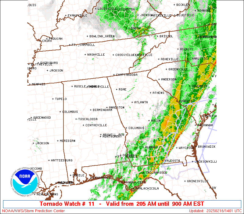
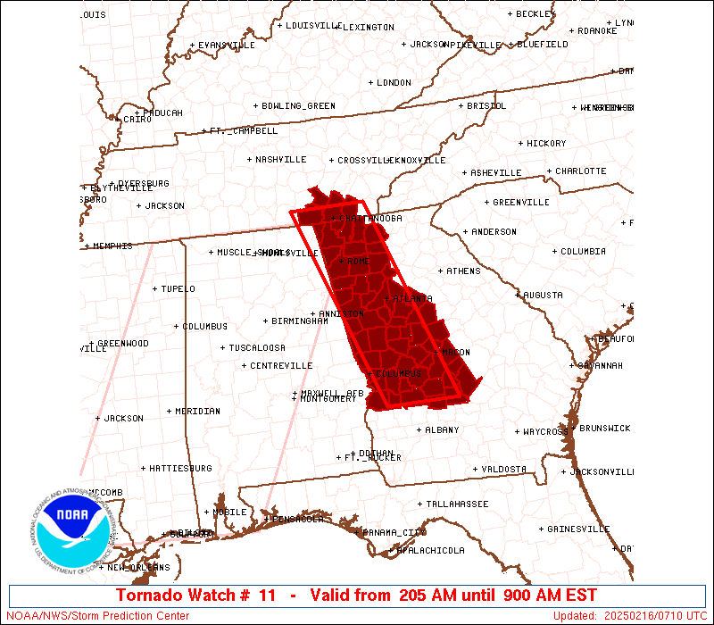
Tornado Watch Number 11
NWS Storm Prediction Center Norman OK
205 AM EST Sun Feb 16 2025
The NWS Storm Prediction Center has issued a
* Tornado Watch for portions of
Northern and Western Georgia
Far Southeast Tennessee
* Effective this Sunday morning from 205 AM until 900 AM EST.
* Primary threats include...
A couple tornadoes possible
Scattered damaging wind gusts to 70 mph likely
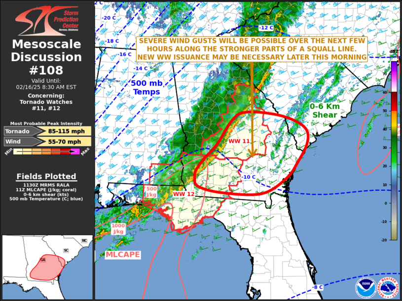
SUMMARY...A line of thunderstorms will continue to pose a threat for
a couple of tornadoes and scattered to numerous damaging winds up to
60-70 mph as it moves quickly eastward early this morning.
The tornado watch area is approximately along and 40 statute miles
east and west of a line from 15 miles north northwest of Chattanooga
TN to 55 miles south southwest of Macon GA. For a complete depiction
of the watch see the associated watch outline update (WOUS64 KWNS
WOU1).
PRECAUTIONARY/PREPAREDNESS ACTIONS...
REMEMBER...A Tornado Watch means conditions are favorable for
tornadoes and severe thunderstorms in and close to the watch
area. Persons in these areas should be on the lookout for
threatening weather conditions and listen for later statements
and possible warnings.
&&
OTHER WATCH INFORMATION...CONTINUE...WW 9...WW 10...
AVIATION...Tornadoes and a few severe thunderstorms with hail
surface and aloft to 1 inch. Extreme turbulence and surface wind
gusts to 60 knots. A few cumulonimbi with maximum tops to 450. Mean
storm motion vector 27045.
...Gleason
 Note:
The Aviation Watch (SAW) product is an approximation to the watch area.
The actual watch is depicted by the shaded areas.
Note:
The Aviation Watch (SAW) product is an approximation to the watch area.
The actual watch is depicted by the shaded areas.
   SAW1
   WW 11 TORNADO GA TN 160705Z - 161400Z
   AXIS..40 STATUTE MILES EAST AND WEST OF LINE..
   15NNW CHA/CHATTANOOGA TN/ - 55SSW MCN/MACON GA/
   ..AVIATION COORDS.. 35NM E/W /18NNW GQO - 23NE PZD/
   HAIL SURFACE AND ALOFT..1 INCH. WIND GUSTS..60 KNOTS.
   MAX TOPS TO 450. MEAN STORM MOTION VECTOR 27045.

   LAT...LON 35238459 31968333 31968469 35238601

   THIS IS AN APPROXIMATION TO THE WATCH AREA.  FOR A
   COMPLETE DEPICTION OF THE WATCH SEE WOUS64 KWNS
   FOR WOU1.
Watch 11 Status Report Messages:
STATUS REPORT #6 ON WW 11

VALID 161230Z - 161340Z

SEVERE WEATHER THREAT CONTINUES RIGHT OF A LINE FROM 40 NE ABY TO
40 NNW VDI TO 10 W AGS.

..BROYLES..02/16/25

ATTN...WFO...FFC...MRX...

&&

STATUS REPORT FOR WT 11

SEVERE WEATHER THREAT CONTINUES FOR THE FOLLOWING AREAS

GAC091-107-175-209-271-279-283-309-161340-

GA
.    GEORGIA COUNTIES INCLUDED ARE

DODGE		     EMANUEL		 LAURENS
MONTGOMERY	     TELFAIR		 TOOMBS
TREUTLEN	     WHEELER
$$


THE WATCH STATUS MESSAGE IS FOR GUIDANCE PURPOSES ONLY.  PLEASE
REFER TO WATCH COUNTY NOTIFICATION STATEMENTS FOR OFFICIAL
INFORMATION ON COUNTIES...INDEPENDENT CITIES AND MARINE ZONES
CLEARED FROM SEVERE THUNDERSTORM AND TORNADO WATCHES.
$$

STATUS REPORT #5 ON WW 11

VALID 161140Z - 161240Z

SEVERE WEATHER THREAT CONTINUES RIGHT OF A LINE FROM 15 NNW ABY
TO 35 NE MCN.

..BROYLES..02/16/25

ATTN...WFO...FFC...MRX...

&&

STATUS REPORT FOR WT 11

SEVERE WEATHER THREAT CONTINUES FOR THE FOLLOWING AREAS

GAC023-081-091-093-107-125-153-163-167-175-209-235-271-279-283-
301-303-309-315-319-161240-

GA
.    GEORGIA COUNTIES INCLUDED ARE

BLECKLEY	     CRISP		 DODGE
DOOLY		     EMANUEL		 GLASCOCK
HOUSTON 	     JEFFERSON		 JOHNSON
LAURENS 	     MONTGOMERY 	 PULASKI
TELFAIR 	     TOOMBS		 TREUTLEN
WARREN		     WASHINGTON 	 WHEELER
WILCOX		     WILKINSON
$$


THE WATCH STATUS MESSAGE IS FOR GUIDANCE PURPOSES ONLY.  PLEASE
REFER TO WATCH COUNTY NOTIFICATION STATEMENTS FOR OFFICIAL
INFORMATION ON COUNTIES...INDEPENDENT CITIES AND MARINE ZONES
CLEARED FROM SEVERE THUNDERSTORM AND TORNADO WATCHES.
$$

STATUS REPORT #4 ON WW 11

VALID 161020Z - 161140Z

SEVERE WEATHER THREAT CONTINUES RIGHT OF A LINE FROM 30 SSW CSG
TO 25 W AHN.

..BROYLES..02/16/25

ATTN...WFO...FFC...MRX...

&&

STATUS REPORT FOR WT 11

SEVERE WEATHER THREAT CONTINUES FOR THE FOLLOWING AREAS

GAC021-023-035-053-079-081-091-093-153-159-169-171-193-197-207-
217-225-235-247-249-259-261-263-269-289-293-307-315-161140-

GA
.    GEORGIA COUNTIES INCLUDED ARE

BIBB		     BLECKLEY		 BUTTS
CHATTAHOOCHEE	     CRAWFORD		 CRISP
DODGE		     DOOLY		 HOUSTON
JASPER		     JONES		 LAMAR
MACON		     MARION		 MONROE
NEWTON		     PEACH		 PULASKI
ROCKDALE	     SCHLEY		 STEWART
SUMTER		     TALBOT		 TAYLOR
TWIGGS		     UPSON		 WEBSTER
WILCOX
$$


THE WATCH STATUS MESSAGE IS FOR GUIDANCE PURPOSES ONLY.  PLEASE
REFER TO WATCH COUNTY NOTIFICATION STATEMENTS FOR OFFICIAL
INFORMATION ON COUNTIES...INDEPENDENT CITIES AND MARINE ZONES
CLEARED FROM SEVERE THUNDERSTORM AND TORNADO WATCHES.
$$

STATUS REPORT #3 ON WW 11

VALID 160935Z - 161040Z

SEVERE WEATHER THREAT CONTINUES RIGHT OF A LINE FROM 15 SW LGC TO
60 ENE RMG.

..BROYLES..02/16/25

ATTN...WFO...FFC...MRX...

&&

STATUS REPORT FOR WT 11

SEVERE WEATHER THREAT CONTINUES FOR THE FOLLOWING AREAS

GAC021-023-035-053-063-077-079-081-089-091-093-113-121-145-151-
153-159-169-171-193-197-199-207-215-217-225-231-235-247-249-255-
259-261-263-269-285-289-293-307-315-161040-

GA
.    GEORGIA COUNTIES INCLUDED ARE

BIBB		     BLECKLEY		 BUTTS
CHATTAHOOCHEE	     CLAYTON		 COWETA
CRAWFORD	     CRISP		 DEKALB
DODGE		     DOOLY		 FAYETTE
FULTON		     HARRIS		 HENRY
HOUSTON 	     JASPER		 JONES
LAMAR		     MACON		 MARION
MERIWETHER	     MONROE		 MUSCOGEE
NEWTON		     PEACH		 PIKE
PULASKI 	     ROCKDALE		 SCHLEY
SPALDING	     STEWART		 SUMTER
TALBOT		     TAYLOR		 TROUP
TWIGGS		     UPSON		 WEBSTER
WILCOX
$$


THE WATCH STATUS MESSAGE IS FOR GUIDANCE PURPOSES ONLY.  PLEASE
REFER TO WATCH COUNTY NOTIFICATION STATEMENTS FOR OFFICIAL
INFORMATION ON COUNTIES...INDEPENDENT CITIES AND MARINE ZONES
CLEARED FROM SEVERE THUNDERSTORM AND TORNADO WATCHES.
$$

STATUS REPORT #2 ON WW 11

VALID 160830Z - 160940Z

SEVERE WEATHER THREAT CONTINUES RIGHT OF A LINE FROM 25 E GAD TO
20 SSE CHA TO 35 NE CHA.

..BROYLES..02/16/25

ATTN...WFO...FFC...MRX...

&&

STATUS REPORT FOR WT 11

SEVERE WEATHER THREAT CONTINUES FOR THE FOLLOWING AREAS

GAC015-021-023-035-045-053-055-057-063-067-077-079-081-089-091-
093-097-113-115-121-123-129-143-145-149-151-153-159-169-171-193-
197-199-207-213-215-217-223-225-227-231-233-235-247-249-255-259-
261-263-269-285-289-293-307-313-315-160940-

GA
.    GEORGIA COUNTIES INCLUDED ARE

BARTOW		     BIBB		 BLECKLEY
BUTTS		     CARROLL		 CHATTAHOOCHEE
CHATTOOGA	     CHEROKEE		 CLAYTON
COBB		     COWETA		 CRAWFORD
CRISP		     DEKALB		 DODGE
DOOLY		     DOUGLAS		 FAYETTE
FLOYD		     FULTON		 GILMER
GORDON		     HARALSON		 HARRIS
HEARD		     HENRY		 HOUSTON
JASPER		     JONES		 LAMAR
MACON		     MARION		 MERIWETHER
MONROE		     MURRAY		 MUSCOGEE
NEWTON		     PAULDING		 PEACH
PICKENS 	     PIKE		 POLK
PULASKI 	     ROCKDALE		 SCHLEY
SPALDING	     STEWART		 SUMTER
TALBOT		     TAYLOR		 TROUP
TWIGGS		     UPSON		 WEBSTER
WHITFIELD	     WILCOX
$$


TNC011-160940-

TN
.    TENNESSEE COUNTIES INCLUDED ARE

BRADLEY
$$


THE WATCH STATUS MESSAGE IS FOR GUIDANCE PURPOSES ONLY.  PLEASE
REFER TO WATCH COUNTY NOTIFICATION STATEMENTS FOR OFFICIAL
INFORMATION ON COUNTIES...INDEPENDENT CITIES AND MARINE ZONES
CLEARED FROM SEVERE THUNDERSTORM AND TORNADO WATCHES.
$$

STATUS REPORT #1 ON WW 11

VALID 160755Z - 160840Z

THE SEVERE WEATHER THREAT CONTINUES ACROSS THE ENTIRE WATCH AREA.

..BROYLES..02/16/25

ATTN...WFO...FFC...MRX...

&&

STATUS REPORT FOR WT 11

SEVERE WEATHER THREAT CONTINUES FOR THE FOLLOWING AREAS

GAC015-021-023-035-045-047-053-055-057-063-067-077-079-081-083-
089-091-093-097-113-115-121-123-129-143-145-149-151-153-159-169-
171-193-197-199-207-213-215-217-223-225-227-231-233-235-247-249-
255-259-261-263-269-285-289-293-295-307-313-315-160840-

GA
.    GEORGIA COUNTIES INCLUDED ARE

BARTOW		     BIBB		 BLECKLEY
BUTTS		     CARROLL		 CATOOSA
CHATTAHOOCHEE	     CHATTOOGA		 CHEROKEE
CLAYTON 	     COBB		 COWETA
CRAWFORD	     CRISP		 DADE
DEKALB		     DODGE		 DOOLY
DOUGLAS 	     FAYETTE		 FLOYD
FULTON		     GILMER		 GORDON
HARALSON	     HARRIS		 HEARD
HENRY		     HOUSTON		 JASPER
JONES		     LAMAR		 MACON
MARION		     MERIWETHER 	 MONROE
MURRAY		     MUSCOGEE		 NEWTON
PAULDING	     PEACH		 PICKENS
PIKE		     POLK		 PULASKI
ROCKDALE	     SCHLEY		 SPALDING
STEWART 	     SUMTER		 TALBOT
TAYLOR		     TROUP		 TWIGGS
UPSON		     WALKER		 WEBSTER
WHITFIELD	     WILCOX
$$


TNC011-065-115-153-160840-

TN
.    TENNESSEE COUNTIES INCLUDED ARE

BRADLEY 	     HAMILTON		 MARION
SEQUATCHIE
$$


THE WATCH STATUS MESSAGE IS FOR GUIDANCE PURPOSES ONLY.  PLEASE
REFER TO WATCH COUNTY NOTIFICATION STATEMENTS FOR OFFICIAL
INFORMATION ON COUNTIES...INDEPENDENT CITIES AND MARINE ZONES
CLEARED FROM SEVERE THUNDERSTORM AND TORNADO WATCHES.
$$
Note:
Click for Complete Product Text.
Tornadoes
Probability of 2 or more tornadoes
|
Mod (40%)
|
Probability of 1 or more strong (EF2-EF5) tornadoes
|
Low (20%)
|
Wind
Probability of 10 or more severe wind events
|
High (70%)
|
Probability of 1 or more wind events > 65 knots
|
Low (20%)
|
Hail
Probability of 10 or more severe hail events
|
Low (<5%)
|
Probability of 1 or more hailstones > 2 inches
|
Low (<5%)
|
Combined Severe Hail/Wind
Probability of 6 or more combined severe hail/wind events
|
High (80%)
|
For each watch, probabilities for particular events inside the watch
(listed above in each table) are determined by the issuing forecaster.
The "Low" category contains probability values ranging from less than 2%
to 20% (EF2-EF5 tornadoes), less than 5% to 20% (all other probabilities),
"Moderate" from 30% to 60%, and "High" from 70% to greater than 95%.
High values are bolded and lighter in color to provide awareness of
an increased threat for a particular event.


 @NWSSPC