|
| Mesoscale Discussion 108 |
|
[an error occurred while processing this directive]
|
|
Mesoscale Discussion 0108
NWS Storm Prediction Center Norman OK
0532 AM CST Sun Feb 16 2025
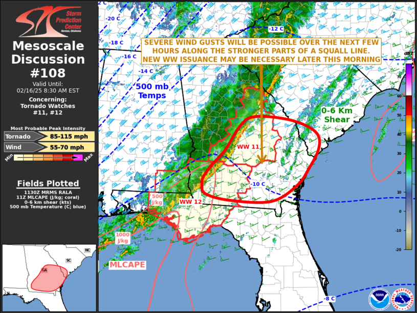
Areas affected...Southern and Eastern Georgia...Far Southern South
Carolina
Concerning...Tornado Watch 11...12...
Valid 161132Z - 161330Z
The severe weather threat for Tornado Watch 11, 12 continues.
SUMMARY...Severe wind gusts and an isolated tornado threat will be
possible as a squall line moves eastward across the remainder of
Georgia this morning. Southern South Carolina will also be affected.
Weather watch issuance may become necessary later this morning, to
the east of the ongoing watches.
DISCUSSION...The latest mosaic radar imagery shows a squall line
located in Georgia from Albany northeastward to about 50 statute
miles west of Augusta. The line is located ahead of a fast-moving
cold front. Surface dewpoints ahead of the line are mostly in the
60s F, with the RAP showing weak instability in place. In spite of
this, the line has remained organized likely due to strong
large-scale ascent associated with an approaching trough, and
frontal forcing. Short-term model forecasts suggest the line will
remain intact for several more hours this morning, as it approaches
the Atlantic coast. The strong low to mid-level flow, evident on
regional WSR-88D VWPs, will likely enable the line to produce severe
gusts, especially with bowing segments that form within the line
itself. Very strong low-level shear will also likely support an
isolated tornado threat in the short-term.
..Broyles/Gleason.. 02/16/2025
...Please see www.spc.noaa.gov for graphic product...
ATTN...WFO...CHS...CAE...JAX...FFC...TAE...
LAT...LON 31238148 31728108 32248076 32668075 32948117 33148191
33218289 32988335 32238389 31798434 31478461 31278464
30998454 30818373 30798235 31238148
|
|
Top/All Mesoscale Discussions/Forecast Products/Home
|
|


 @NWSSPC