 Note:
The expiration time in the watch graphic is amended if the watch is
replaced, cancelled or extended.
Note:
Note:
The expiration time in the watch graphic is amended if the watch is
replaced, cancelled or extended.
Note: Click for
Watch Status Reports.
SEL0
URGENT - IMMEDIATE BROADCAST REQUESTED
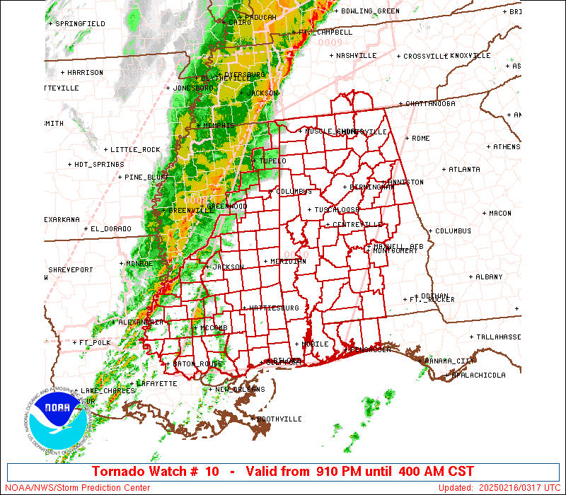
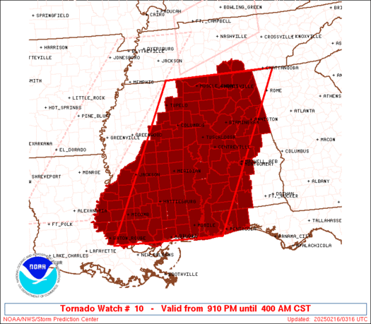
Tornado Watch Number 10
NWS Storm Prediction Center Norman OK
910 PM CST Sat Feb 15 2025
The NWS Storm Prediction Center has issued a
* Tornado Watch for portions of
Much of Alabama
Western Florida Panhandle
Southeast Louisiana
Central and Southern Mississippi
Southern Middle Tennessee
Coastal Waters
* Effective this Saturday night and Sunday morning from 910 PM
until 400 AM CST.
* Primary threats include...
A few tornadoes likely with a couple intense tornadoes possible
Widespread damaging wind gusts to 70 mph likely
Isolated large hail events to 1.5 inches in diameter possible
SUMMARY...A fast-moving line of thunderstorms will overspread the
watch area through the early morning hours. Very strong winds aloft
ahead of the line will pose a risk of damaging wind gusts and
embedded tornadoes.
The tornado watch area is approximately along and 110 statute miles
east and west of a line from 10 miles southwest of Gulfport MS to 25
miles north of Huntsville AL. For a complete depiction of the watch
see the associated watch outline update (WOUS64 KWNS WOU0).
PRECAUTIONARY/PREPAREDNESS ACTIONS...
REMEMBER...A Tornado Watch means conditions are favorable for
tornadoes and severe thunderstorms in and close to the watch
area. Persons in these areas should be on the lookout for
threatening weather conditions and listen for later statements
and possible warnings.
&&
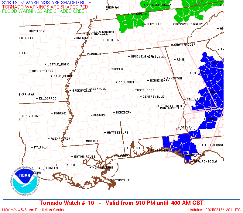
OTHER WATCH INFORMATION...CONTINUE...WW 8...WW 9...
AVIATION...Tornadoes and a few severe thunderstorms with hail
surface and aloft to 1.5 inches. Extreme turbulence and surface wind
gusts to 60 knots. A few cumulonimbi with maximum tops to 450. Mean
storm motion vector 27035.
...Hart
 Note:
The Aviation Watch (SAW) product is an approximation to the watch area.
The actual watch is depicted by the shaded areas.
Note:
The Aviation Watch (SAW) product is an approximation to the watch area.
The actual watch is depicted by the shaded areas.
   SAW0
   WW 10 TORNADO AL FL LA MS TN CW 160310Z - 161000Z
   AXIS..110 STATUTE MILES EAST AND WEST OF LINE..
   10SW GPT/GULFPORT MS/ - 25N HSV/HUNTSVILLE AL/
   ..AVIATION COORDS.. 95NM E/W /50ENE HRV - 39ENE MSL/
   HAIL SURFACE AND ALOFT..1.5 INCHES. WIND GUSTS..60 KNOTS.
   MAX TOPS TO 450. MEAN STORM MOTION VECTOR 27035.

   LAT...LON 30289103 35008872 35008484 30288734

   THIS IS AN APPROXIMATION TO THE WATCH AREA.  FOR A
   COMPLETE DEPICTION OF THE WATCH SEE WOUS64 KWNS
   FOR WOU0.
Watch 10 Status Report Messages:
STATUS REPORT #5 ON WW 10

VALID 160830Z - 160940Z

SEVERE WEATHER THREAT CONTINUES RIGHT OF A LINE FROM 25 S ASD TO
40 WNW GZH TO 45 N MGM TO 10 NNW RMG.

..BROYLES..02/16/25

ATTN...WFO...BMX...MOB...HUN...LIX...JAN...MEG...

&&

STATUS REPORT FOR WT 10

SEVERE WEATHER THREAT CONTINUES FOR THE FOLLOWING AREAS

ALC001-003-005-011-013-017-019-027-029-035-037-039-041-051-053-
081-085-087-097-099-101-109-111-113-123-160940-

AL
.    ALABAMA COUNTIES INCLUDED ARE

AUTAUGA 	     BALDWIN		 BARBOUR
BULLOCK 	     BUTLER		 CHAMBERS
CHEROKEE	     CLAY		 CLEBURNE
CONECUH 	     COOSA		 COVINGTON
CRENSHAW	     ELMORE		 ESCAMBIA
LEE		     LOWNDES		 MACON
MOBILE		     MONROE		 MONTGOMERY
PIKE		     RANDOLPH		 RUSSELL
TALLAPOOSA
$$


FLC033-091-113-160940-

FL
.    FLORIDA COUNTIES INCLUDED ARE

ESCAMBIA	     OKALOOSA		 SANTA ROSA
$$


MSC039-047-059-160940-

MS
.    MISSISSIPPI COUNTIES INCLUDED ARE

GEORGE		     HARRISON		 JACKSON
$$


GMZ630-631-632-634-635-160940-

CW

.    ADJACENT COASTAL WATERS INCLUDED ARE

NORTH MOBILE BAY

SOUTH MOBILE BAY

MISSISSIPPI SOUND

PENSACOLA BAY AREA INCLUDING SANTA ROSA SOUND

WESTERN CHOCTAWHATCHEE BAY

$$
THE WATCH STATUS MESSAGE IS FOR GUIDANCE PURPOSES ONLY.  PLEASE
REFER TO WATCH COUNTY NOTIFICATION STATEMENTS FOR OFFICIAL
INFORMATION ON COUNTIES...INDEPENDENT CITIES AND MARINE ZONES
CLEARED FROM SEVERE THUNDERSTORM AND TORNADO WATCHES.
$$

STATUS REPORT #4 ON WW 10

VALID 160755Z - 160840Z

SEVERE WEATHER THREAT CONTINUES RIGHT OF A LINE FROM 15 NE MSY TO
25 W SEM TO 20 SW GAD TO 15 WSW CHA.

..BROYLES..02/16/25

ATTN...WFO...BMX...MOB...HUN...LIX...JAN...MEG...

&&

STATUS REPORT FOR WT 10

SEVERE WEATHER THREAT CONTINUES FOR THE FOLLOWING AREAS

ALC001-003-005-011-013-015-017-019-021-025-027-029-035-037-039-
041-047-051-053-055-081-085-087-097-099-101-109-111-113-117-121-
123-129-131-160840-

AL
.    ALABAMA COUNTIES INCLUDED ARE

AUTAUGA 	     BALDWIN		 BARBOUR
BULLOCK 	     BUTLER		 CALHOUN
CHAMBERS	     CHEROKEE		 CHILTON
CLARKE		     CLAY		 CLEBURNE
CONECUH 	     COOSA		 COVINGTON
CRENSHAW	     DALLAS		 ELMORE
ESCAMBIA	     ETOWAH		 LEE
LOWNDES 	     MACON		 MOBILE
MONROE		     MONTGOMERY 	 PIKE
RANDOLPH	     RUSSELL		 SHELBY
TALLADEGA	     TALLAPOOSA 	 WASHINGTON
WILCOX
$$


FLC033-091-113-160840-

FL
.    FLORIDA COUNTIES INCLUDED ARE

ESCAMBIA	     OKALOOSA		 SANTA ROSA
$$


MSC039-041-045-047-059-131-160840-

MS
.    MISSISSIPPI COUNTIES INCLUDED ARE

GEORGE		     GREENE		 HANCOCK
HARRISON	     JACKSON		 STONE
$$


GMZ630-631-632-634-635-160840-

CW

.    ADJACENT COASTAL WATERS INCLUDED ARE

NORTH MOBILE BAY

SOUTH MOBILE BAY

MISSISSIPPI SOUND

PENSACOLA BAY AREA INCLUDING SANTA ROSA SOUND

WESTERN CHOCTAWHATCHEE BAY

$$
THE WATCH STATUS MESSAGE IS FOR GUIDANCE PURPOSES ONLY.  PLEASE
REFER TO WATCH COUNTY NOTIFICATION STATEMENTS FOR OFFICIAL
INFORMATION ON COUNTIES...INDEPENDENT CITIES AND MARINE ZONES
CLEARED FROM SEVERE THUNDERSTORM AND TORNADO WATCHES.
$$

STATUS REPORT #3 ON WW 10

VALID 160710Z - 160840Z

SEVERE WEATHER THREAT CONTINUES RIGHT OF A LINE FROM 25 N HUM TO
20 E PIB TO 40 SSW TCL TO 30 N BHM TO 30 E HSV TO 45 WNW CHA.

..BROYLES..02/16/25

ATTN...WFO...BMX...MOB...HUN...LIX...JAN...MEG...

&&

STATUS REPORT FOR WT 10

SEVERE WEATHER THREAT CONTINUES FOR THE FOLLOWING AREAS

ALC001-003-007-009-013-015-019-021-023-025-027-029-035-037-039-
041-047-049-051-053-055-065-071-073-085-091-095-097-099-101-105-
111-115-117-121-123-129-131-160840-

AL
.    ALABAMA COUNTIES INCLUDED ARE

AUTAUGA 	     BALDWIN		 BIBB
BLOUNT		     BUTLER		 CALHOUN
CHEROKEE	     CHILTON		 CHOCTAW
CLARKE		     CLAY		 CLEBURNE
CONECUH 	     COOSA		 COVINGTON
CRENSHAW	     DALLAS		 DEKALB
ELMORE		     ESCAMBIA		 ETOWAH
HALE		     JACKSON		 JEFFERSON
LOWNDES 	     MARENGO		 MARSHALL
MOBILE		     MONROE		 MONTGOMERY
PERRY		     RANDOLPH		 ST. CLAIR
SHELBY		     TALLADEGA		 TALLAPOOSA
WASHINGTON	     WILCOX
$$


FLC033-091-113-160840-

FL
.    FLORIDA COUNTIES INCLUDED ARE

ESCAMBIA	     OKALOOSA		 SANTA ROSA
$$


LAC103-160840-

LA
.    LOUISIANA PARISHES INCLUDED ARE

ST. TAMMANY
$$


MSC035-039-041-045-047-059-109-111-131-153-160840-

MS
.    MISSISSIPPI COUNTIES INCLUDED ARE

FORREST 	     GEORGE		 GREENE
HANCOCK 	     HARRISON		 JACKSON
PEARL RIVER	     PERRY		 STONE
WAYNE
$$


GMZ630-631-632-634-635-160840-

CW

.    ADJACENT COASTAL WATERS INCLUDED ARE

NORTH MOBILE BAY

SOUTH MOBILE BAY

MISSISSIPPI SOUND

PENSACOLA BAY AREA INCLUDING SANTA ROSA SOUND

WESTERN CHOCTAWHATCHEE BAY

$$
THE WATCH STATUS MESSAGE IS FOR GUIDANCE PURPOSES ONLY.  PLEASE
REFER TO WATCH COUNTY NOTIFICATION STATEMENTS FOR OFFICIAL
INFORMATION ON COUNTIES...INDEPENDENT CITIES AND MARINE ZONES
CLEARED FROM SEVERE THUNDERSTORM AND TORNADO WATCHES.
$$

STATUS REPORT #2 ON WW 10

VALID 160530Z - 160640Z

SEVERE WEATHER THREAT CONTINUES RIGHT OF A LINE FROM 15 NE LFT TO
5 NW MCB TO 45 NW PIB TO 45 WNW MEI TO 35 SW CBM TO 20 NE CBM TO
30 NNE MSL.

..THORNTON..02/16/25

ATTN...WFO...BMX...MOB...HUN...LIX...JAN...MEG...

&&

STATUS REPORT FOR WT 10

SEVERE WEATHER THREAT CONTINUES FOR THE FOLLOWING AREAS

ALC001-003-007-009-013-015-019-021-023-025-027-029-035-037-039-
041-043-047-049-051-053-055-057-063-065-071-073-075-079-083-085-
089-091-093-095-097-099-101-103-105-107-111-115-117-119-121-123-
125-127-129-131-133-160640-

AL
.    ALABAMA COUNTIES INCLUDED ARE

AUTAUGA 	     BALDWIN		 BIBB
BLOUNT		     BUTLER		 CALHOUN
CHEROKEE	     CHILTON		 CHOCTAW
CLARKE		     CLAY		 CLEBURNE
CONECUH 	     COOSA		 COVINGTON
CRENSHAW	     CULLMAN		 DALLAS
DEKALB		     ELMORE		 ESCAMBIA
ETOWAH		     FAYETTE		 GREENE
HALE		     JACKSON		 JEFFERSON
LAMAR		     LAWRENCE		 LIMESTONE
LOWNDES 	     MADISON		 MARENGO
MARION		     MARSHALL		 MOBILE
MONROE		     MONTGOMERY 	 MORGAN
PERRY		     PICKENS		 RANDOLPH
ST. CLAIR	     SHELBY		 SUMTER
TALLADEGA	     TALLAPOOSA 	 TUSCALOOSA
WALKER		     WASHINGTON 	 WILCOX
WINSTON
$$


FLC033-091-113-160640-

FL
.    FLORIDA COUNTIES INCLUDED ARE

ESCAMBIA	     OKALOOSA		 SANTA ROSA
$$


LAC033-063-091-103-105-117-121-160640-

LA
.    LOUISIANA PARISHES INCLUDED ARE

EAST BATON ROUGE     LIVINGSTON 	 ST. HELENA
ST. TAMMANY	     TANGIPAHOA 	 WASHINGTON
WEST BATON ROUGE
$$


MSC023-031-035-039-041-045-047-059-061-065-067-069-073-075-077-
087-091-099-101-103-109-111-113-123-129-131-147-153-159-
160640-

MS
.    MISSISSIPPI COUNTIES INCLUDED ARE

CLARKE		     COVINGTON		 FORREST
GEORGE		     GREENE		 HANCOCK
HARRISON	     JACKSON		 JASPER
JEFFERSON DAVIS      JONES		 KEMPER
LAMAR		     LAUDERDALE 	 LAWRENCE
LOWNDES 	     MARION		 NESHOBA
NEWTON		     NOXUBEE		 PEARL RIVER
PERRY		     PIKE		 SCOTT
SMITH		     STONE		 WALTHALL
WAYNE		     WINSTON
$$


TNC051-103-127-160640-

TN
.    TENNESSEE COUNTIES INCLUDED ARE

FRANKLIN	     LINCOLN		 MOORE
$$


GMZ630-631-632-634-635-160640-

CW

.    ADJACENT COASTAL WATERS INCLUDED ARE

NORTH MOBILE BAY

SOUTH MOBILE BAY

MISSISSIPPI SOUND

PENSACOLA BAY AREA INCLUDING SANTA ROSA SOUND

WESTERN CHOCTAWHATCHEE BAY

$$
THE WATCH STATUS MESSAGE IS FOR GUIDANCE PURPOSES ONLY.  PLEASE
REFER TO WATCH COUNTY NOTIFICATION STATEMENTS FOR OFFICIAL
INFORMATION ON COUNTIES...INDEPENDENT CITIES AND MARINE ZONES
CLEARED FROM SEVERE THUNDERSTORM AND TORNADO WATCHES.
$$

STATUS REPORT #1 ON WW 10

VALID 160530Z - 160640Z

SEVERE WEATHER THREAT CONTINUES RIGHT OF A LINE FROM 15 NE LFT TO
5 NW MCB TO 45 NW PIB TO 45 WNW MEI TO 35 SW CBM TO 20 NE CBM TO
30 NNE MSL.

..THORNTON..02/16/25

ATTN...WFO...BMX...MOB...HUN...LIX...JAN...MEG...

&&

STATUS REPORT FOR WT 10

SEVERE WEATHER THREAT CONTINUES FOR THE FOLLOWING AREAS

ALC001-003-007-009-013-015-019-021-023-025-027-029-035-037-039-
041-043-047-049-051-053-055-057-063-065-071-073-075-079-083-085-
089-091-093-095-097-099-101-103-105-107-111-115-117-119-121-123-
125-127-129-131-133-160640-

AL
.    ALABAMA COUNTIES INCLUDED ARE

AUTAUGA 	     BALDWIN		 BIBB
BLOUNT		     BUTLER		 CALHOUN
CHEROKEE	     CHILTON		 CHOCTAW
CLARKE		     CLAY		 CLEBURNE
CONECUH 	     COOSA		 COVINGTON
CRENSHAW	     CULLMAN		 DALLAS
DEKALB		     ELMORE		 ESCAMBIA
ETOWAH		     FAYETTE		 GREENE
HALE		     JACKSON		 JEFFERSON
LAMAR		     LAWRENCE		 LIMESTONE
LOWNDES 	     MADISON		 MARENGO
MARION		     MARSHALL		 MOBILE
MONROE		     MONTGOMERY 	 MORGAN
PERRY		     PICKENS		 RANDOLPH
ST. CLAIR	     SHELBY		 SUMTER
TALLADEGA	     TALLAPOOSA 	 TUSCALOOSA
WALKER		     WASHINGTON 	 WILCOX
WINSTON
$$


FLC033-091-113-160640-

FL
.    FLORIDA COUNTIES INCLUDED ARE

ESCAMBIA	     OKALOOSA		 SANTA ROSA
$$


LAC033-063-091-103-105-117-121-160640-

LA
.    LOUISIANA PARISHES INCLUDED ARE

EAST BATON ROUGE     LIVINGSTON 	 ST. HELENA
ST. TAMMANY	     TANGIPAHOA 	 WASHINGTON
WEST BATON ROUGE
$$


MSC023-031-035-039-041-045-047-059-061-065-067-069-073-075-077-
087-091-099-101-103-109-111-113-123-129-131-147-153-159-
160640-

MS
.    MISSISSIPPI COUNTIES INCLUDED ARE

CLARKE		     COVINGTON		 FORREST
GEORGE		     GREENE		 HANCOCK
HARRISON	     JACKSON		 JASPER
JEFFERSON DAVIS      JONES		 KEMPER
LAMAR		     LAUDERDALE 	 LAWRENCE
LOWNDES 	     MARION		 NESHOBA
NEWTON		     NOXUBEE		 PEARL RIVER
PERRY		     PIKE		 SCOTT
SMITH		     STONE		 WALTHALL
WAYNE		     WINSTON
$$


TNC051-103-127-160640-

TN
.    TENNESSEE COUNTIES INCLUDED ARE

FRANKLIN	     LINCOLN		 MOORE
$$


GMZ630-631-632-634-635-160640-

CW

.    ADJACENT COASTAL WATERS INCLUDED ARE

NORTH MOBILE BAY

SOUTH MOBILE BAY

MISSISSIPPI SOUND

PENSACOLA BAY AREA INCLUDING SANTA ROSA SOUND

WESTERN CHOCTAWHATCHEE BAY

$$
THE WATCH STATUS MESSAGE IS FOR GUIDANCE PURPOSES ONLY.  PLEASE
REFER TO WATCH COUNTY NOTIFICATION STATEMENTS FOR OFFICIAL
INFORMATION ON COUNTIES...INDEPENDENT CITIES AND MARINE ZONES
CLEARED FROM SEVERE THUNDERSTORM AND TORNADO WATCHES.
$$
Note:
Click for Complete Product Text.
Tornadoes
Probability of 2 or more tornadoes
|
Mod (60%)
|
Probability of 1 or more strong (EF2-EF5) tornadoes
|
Mod (40%)
|
Wind
Probability of 10 or more severe wind events
|
High (90%)
|
Probability of 1 or more wind events > 65 knots
|
Low (10%)
|
Hail
Probability of 10 or more severe hail events
|
Low (20%)
|
Probability of 1 or more hailstones > 2 inches
|
Low (<5%)
|
Combined Severe Hail/Wind
Probability of 6 or more combined severe hail/wind events
|
High (>95%)
|
For each watch, probabilities for particular events inside the watch
(listed above in each table) are determined by the issuing forecaster.
The "Low" category contains probability values ranging from less than 2%
to 20% (EF2-EF5 tornadoes), less than 5% to 20% (all other probabilities),
"Moderate" from 30% to 60%, and "High" from 70% to greater than 95%.
High values are bolded and lighter in color to provide awareness of
an increased threat for a particular event.


 @NWSSPC