Note:
The expiration time in the watch graphic is amended if the watch is
replaced, cancelled or extended.
Note:
Note:
The expiration time in the watch graphic is amended if the watch is
replaced, cancelled or extended.
Note: Click for
Watch Status Reports.
SEL8
URGENT - IMMEDIATE BROADCAST REQUESTED
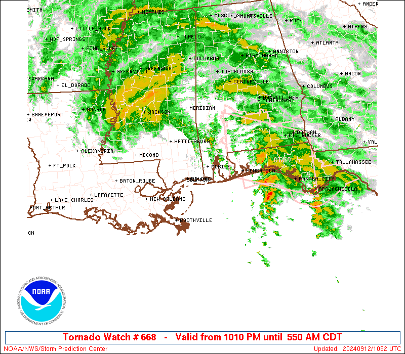
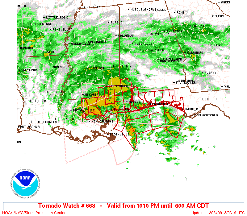
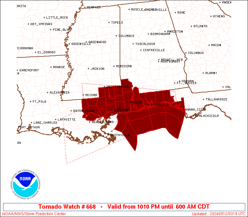
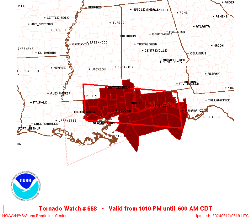
Tornado Watch Number 668
NWS Storm Prediction Center Norman OK
1010 PM CDT Wed Sep 11 2024
The NWS Storm Prediction Center has issued a
* Tornado Watch for portions of
Southwest Alabama
Florida Panhandle
Southeast Louisiana
Southern Mississippi
Coastal Waters
* Effective this Wednesday night and Thursday morning from 1010
PM until 600 AM CDT.
* Primary threats include...
A couple tornadoes possible
SUMMARY...A few transient small supercells within the convective
bands of Francine will pose a risk for a couple of tornadoes tonight
into the early morning across the Watch area. This threat will
gradually spread northward and inland tonight.
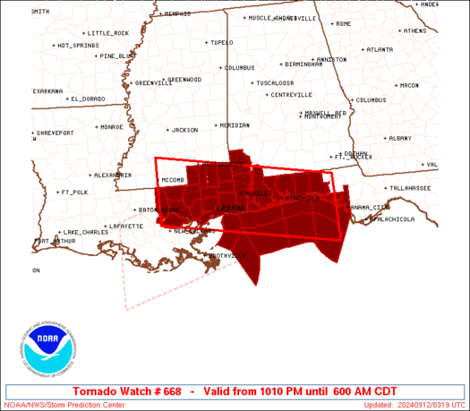
The tornado watch area is approximately along and 55 statute miles
north and south of a line from 55 miles northwest of Slidell LA to
65 miles southeast of Crestview FL. For a complete depiction of the
watch see the associated watch outline update (WOUS64 KWNS WOU8).
PRECAUTIONARY/PREPAREDNESS ACTIONS...
REMEMBER...A Tornado Watch means conditions are favorable for
tornadoes and severe thunderstorms in and close to the watch
area. Persons in these areas should be on the lookout for
threatening weather conditions and listen for later statements
and possible warnings.
&&
OTHER WATCH INFORMATION...CONTINUE...WW 667...
AVIATION...Tornadoes and a few severe thunderstorms with hail
surface and aloft to 0 inches. Extreme turbulence and surface wind
gusts to 50 knots. A few cumulonimbi with maximum tops to 500. Mean
storm motion vector 13020.
...Smith
 Note:
The Aviation Watch (SAW) product is an approximation to the watch area.
The actual watch is depicted by the shaded areas.
Note:
The Aviation Watch (SAW) product is an approximation to the watch area.
The actual watch is depicted by the shaded areas.
   SAW8
   WW 668 TORNADO AL FL LA MS CW 120310Z - 121100Z
   AXIS..55 STATUTE MILES NORTH AND SOUTH OF LINE..
   55NW ASD/SLIDELL LA/ - 65SE CEW/CRESTVIEW FL/
   ..AVIATION COORDS.. 50NM N/S /26SSW MCB - 65SE CEW/
   WIND GUSTS..50 KNOTS.
   MAX TOPS TO 500.MEAN STORM MOTION VECTOR 13020.

   LAT...LON 31719048 30918575 29328575 30129048

   THIS IS AN APPROXIMATION TO THE WATCH AREA.  FOR A
   COMPLETE DEPICTION OF THE WATCH SEE WOUS64 KWNS
   FOR WOU8.
Watch 668 Status Report Messages:
STATUS REPORT #7 ON WW 668
VALID 121035Z - 121100Z
SEVERE WEATHER THREAT CONTINUES RIGHT OF A LINE FROM 60 SSW PNS
TO 40 SW PNS TO 20 NNE MOB TO 50 N MOB.
A NEW TORNADO WW WILL BE ISSUED PRIOR TO 12/11Z.
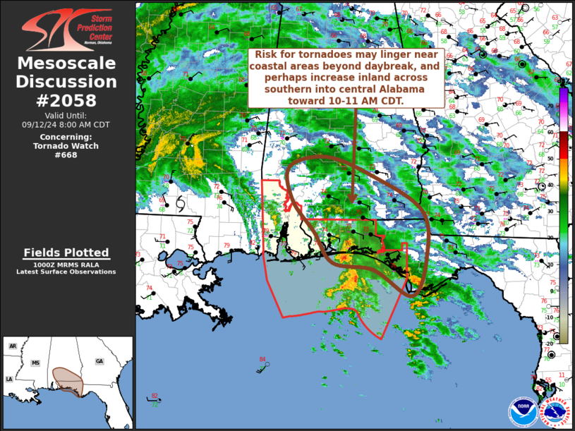
FOR ADDITIONAL INFORMATION SEE MESOSCALE DISCUSSION 2058.
..KERR..09/12/24
ATTN...WFO...MOB...TAE...LIX...JAN...
&&
STATUS REPORT FOR WT 668
SEVERE WEATHER THREAT CONTINUES FOR THE FOLLOWING AREAS
ALC003-097-129-121100-
AL
. ALABAMA COUNTIES INCLUDED ARE
BALDWIN MOBILE WASHINGTON
$$
FLC005-033-091-113-131-121100-
FL
. FLORIDA COUNTIES INCLUDED ARE
BAY ESCAMBIA OKALOOSA
SANTA ROSA WALTON
$$
GMZ630-631-633-634-635-636-650-655-675-750-770-121100-
CW
. ADJACENT COASTAL WATERS INCLUDED ARE
NORTH MOBILE BAY
SOUTH MOBILE BAY
PERDIDO BAY AREA
PENSACOLA BAY AREA INCLUDING SANTA ROSA SOUND
WESTERN CHOCTAWHATCHEE BAY
EASTERN CHOCTAWHATCHEE BAY
COASTAL WATERS FROM PENSACOLA FL TO PASCAGOULA MS OUT 20 NM
COASTAL WATERS FROM OKALOOSA-WALTON COUNTY LINE TO PENSACOLA FL
OUT 20 NM
WATERS FROM OKALOOSA-WALTON COUNTY LINE TO PENSACOLA FL FROM 20
TO 60 NM
COASTAL WATERS FROM OKALOOSA-WALTON COUNTY LINE TO MEXICO BEACH
OUT 20 NM
WATERS FROM OKALOOSA-WALTON COUNTY LINE TO MEXICO BEACH FROM 20
TO 60 NM
$$
THE WATCH STATUS MESSAGE IS FOR GUIDANCE PURPOSES ONLY. PLEASE
REFER TO WATCH COUNTY NOTIFICATION STATEMENTS FOR OFFICIAL
INFORMATION ON COUNTIES...INDEPENDENT CITIES AND MARINE ZONES
CLEARED FROM SEVERE THUNDERSTORM AND TORNADO WATCHES.
$$
STATUS REPORT #6 ON WW 668
VALID 121010Z - 121140Z
SEVERE WEATHER THREAT CONTINUES RIGHT OF A LINE FROM 60 SSW PNS
TO 40 SW PNS TO 20 NNE MOB TO 50 N MOB.
..KERR..09/12/24
ATTN...WFO...MOB...TAE...LIX...JAN...
&&
STATUS REPORT FOR WT 668
SEVERE WEATHER THREAT CONTINUES FOR THE FOLLOWING AREAS
ALC003-097-129-121140-
AL
. ALABAMA COUNTIES INCLUDED ARE
BALDWIN MOBILE WASHINGTON
$$
FLC005-033-091-113-131-121140-
FL
. FLORIDA COUNTIES INCLUDED ARE
BAY ESCAMBIA OKALOOSA
SANTA ROSA WALTON
$$
GMZ630-631-633-634-635-636-650-655-675-750-770-121140-
CW
. ADJACENT COASTAL WATERS INCLUDED ARE
NORTH MOBILE BAY
SOUTH MOBILE BAY
PERDIDO BAY AREA
PENSACOLA BAY AREA INCLUDING SANTA ROSA SOUND
WESTERN CHOCTAWHATCHEE BAY
EASTERN CHOCTAWHATCHEE BAY
COASTAL WATERS FROM PENSACOLA FL TO PASCAGOULA MS OUT 20 NM
COASTAL WATERS FROM OKALOOSA-WALTON COUNTY LINE TO PENSACOLA FL
OUT 20 NM
WATERS FROM OKALOOSA-WALTON COUNTY LINE TO PENSACOLA FL FROM 20
TO 60 NM
COASTAL WATERS FROM OKALOOSA-WALTON COUNTY LINE TO MEXICO BEACH
OUT 20 NM
WATERS FROM OKALOOSA-WALTON COUNTY LINE TO MEXICO BEACH FROM 20
TO 60 NM
$$
THE WATCH STATUS MESSAGE IS FOR GUIDANCE PURPOSES ONLY. PLEASE
REFER TO WATCH COUNTY NOTIFICATION STATEMENTS FOR OFFICIAL
INFORMATION ON COUNTIES...INDEPENDENT CITIES AND MARINE ZONES
CLEARED FROM SEVERE THUNDERSTORM AND TORNADO WATCHES.
$$
STATUS REPORT #5 ON WW 668
VALID 120830Z - 120940Z
SEVERE WEATHER THREAT CONTINUES RIGHT OF A LINE FROM 55 SSW PNS
TO 40 SW PNS TO 20 SSW MOB TO 50 N MOB.
..KERR..09/12/24
ATTN...WFO...MOB...TAE...LIX...JAN...
&&
STATUS REPORT FOR WT 668
SEVERE WEATHER THREAT CONTINUES FOR THE FOLLOWING AREAS
ALC003-097-129-120940-
AL
. ALABAMA COUNTIES INCLUDED ARE
BALDWIN MOBILE WASHINGTON
$$
FLC005-033-091-113-131-120940-
FL
. FLORIDA COUNTIES INCLUDED ARE
BAY ESCAMBIA OKALOOSA
SANTA ROSA WALTON
$$
GMZ630-631-632-633-634-635-636-650-655-675-750-770-120940-
CW
. ADJACENT COASTAL WATERS INCLUDED ARE
NORTH MOBILE BAY
SOUTH MOBILE BAY
MISSISSIPPI SOUND
PERDIDO BAY AREA
PENSACOLA BAY AREA INCLUDING SANTA ROSA SOUND
WESTERN CHOCTAWHATCHEE BAY
EASTERN CHOCTAWHATCHEE BAY
COASTAL WATERS FROM PENSACOLA FL TO PASCAGOULA MS OUT 20 NM
COASTAL WATERS FROM OKALOOSA-WALTON COUNTY LINE TO PENSACOLA FL
OUT 20 NM
WATERS FROM OKALOOSA-WALTON COUNTY LINE TO PENSACOLA FL FROM 20
TO 60 NM
COASTAL WATERS FROM OKALOOSA-WALTON COUNTY LINE TO MEXICO BEACH
OUT 20 NM
WATERS FROM OKALOOSA-WALTON COUNTY LINE TO MEXICO BEACH FROM 20
TO 60 NM
$$
THE WATCH STATUS MESSAGE IS FOR GUIDANCE PURPOSES ONLY. PLEASE
REFER TO WATCH COUNTY NOTIFICATION STATEMENTS FOR OFFICIAL
INFORMATION ON COUNTIES...INDEPENDENT CITIES AND MARINE ZONES
CLEARED FROM SEVERE THUNDERSTORM AND TORNADO WATCHES.
$$
STATUS REPORT #4 ON WW 668
VALID 120825Z - 120940Z
SEVERE WEATHER THREAT CONTINUES RIGHT OF A LINE FROM 55 SSW PNS
TO 40 SW PNS TO 20 SSW MOB TO 50 N MOB.
..KERR..09/12/24
ATTN...WFO...MOB...TAE...LIX...JAN...
&&
STATUS REPORT FOR WT 668
SEVERE WEATHER THREAT CONTINUES FOR THE FOLLOWING AREAS
ALC003-097-129-120940-
AL
. ALABAMA COUNTIES INCLUDED ARE
BALDWIN MOBILE WASHINGTON
$$
FLC005-033-091-113-131-120940-
FL
. FLORIDA COUNTIES INCLUDED ARE
BAY ESCAMBIA OKALOOSA
SANTA ROSA WALTON
$$
GMZ630-631-632-633-634-635-636-650-655-675-750-770-120940-
CW
. ADJACENT COASTAL WATERS INCLUDED ARE
NORTH MOBILE BAY
SOUTH MOBILE BAY
MISSISSIPPI SOUND
PERDIDO BAY AREA
PENSACOLA BAY AREA INCLUDING SANTA ROSA SOUND
WESTERN CHOCTAWHATCHEE BAY
EASTERN CHOCTAWHATCHEE BAY
COASTAL WATERS FROM PENSACOLA FL TO PASCAGOULA MS OUT 20 NM
COASTAL WATERS FROM OKALOOSA-WALTON COUNTY LINE TO PENSACOLA FL
OUT 20 NM
WATERS FROM OKALOOSA-WALTON COUNTY LINE TO PENSACOLA FL FROM 20
TO 60 NM
COASTAL WATERS FROM OKALOOSA-WALTON COUNTY LINE TO MEXICO BEACH
OUT 20 NM
WATERS FROM OKALOOSA-WALTON COUNTY LINE TO MEXICO BEACH FROM 20
TO 60 NM
$$
THE WATCH STATUS MESSAGE IS FOR GUIDANCE PURPOSES ONLY. PLEASE
REFER TO WATCH COUNTY NOTIFICATION STATEMENTS FOR OFFICIAL
INFORMATION ON COUNTIES...INDEPENDENT CITIES AND MARINE ZONES
CLEARED FROM SEVERE THUNDERSTORM AND TORNADO WATCHES.
$$
STATUS REPORT #3 ON WW 668
VALID 120735Z - 120840Z
SEVERE WEATHER THREAT CONTINUES RIGHT OF A LINE FROM 60 SSW PNS
TO 40 SW PNS TO 10 E GPT TO 35 S PIB TO 5 NNE PIB.
..KERR..09/12/24
ATTN...WFO...MOB...TAE...LIX...JAN...
&&
STATUS REPORT FOR WT 668
SEVERE WEATHER THREAT CONTINUES FOR THE FOLLOWING AREAS
ALC003-097-129-120840-
AL
. ALABAMA COUNTIES INCLUDED ARE
BALDWIN MOBILE WASHINGTON
$$
FLC005-033-091-113-131-120840-
FL
. FLORIDA COUNTIES INCLUDED ARE
BAY ESCAMBIA OKALOOSA
SANTA ROSA WALTON
$$
MSC035-039-041-047-059-111-131-120840-
MS
. MISSISSIPPI COUNTIES INCLUDED ARE
FORREST GEORGE GREENE
HARRISON JACKSON PERRY
STONE
$$
GMZ630-631-632-633-634-635-636-650-655-670-675-750-770-120840-
CW
. ADJACENT COASTAL WATERS INCLUDED ARE
NORTH MOBILE BAY
SOUTH MOBILE BAY
MISSISSIPPI SOUND
PERDIDO BAY AREA
PENSACOLA BAY AREA INCLUDING SANTA ROSA SOUND
WESTERN CHOCTAWHATCHEE BAY
EASTERN CHOCTAWHATCHEE BAY
COASTAL WATERS FROM PENSACOLA FL TO PASCAGOULA MS OUT 20 NM
COASTAL WATERS FROM OKALOOSA-WALTON COUNTY LINE TO PENSACOLA FL
OUT 20 NM
WATERS FROM PENSACOLA FL TO PASCAGOULA MS FROM 20 TO 60 NM
WATERS FROM OKALOOSA-WALTON COUNTY LINE TO PENSACOLA FL FROM 20
TO 60 NM
COASTAL WATERS FROM OKALOOSA-WALTON COUNTY LINE TO MEXICO BEACH
OUT 20 NM
WATERS FROM OKALOOSA-WALTON COUNTY LINE TO MEXICO BEACH FROM 20
TO 60 NM
$$
THE WATCH STATUS MESSAGE IS FOR GUIDANCE PURPOSES ONLY. PLEASE
REFER TO WATCH COUNTY NOTIFICATION STATEMENTS FOR OFFICIAL
INFORMATION ON COUNTIES...INDEPENDENT CITIES AND MARINE ZONES
CLEARED FROM SEVERE THUNDERSTORM AND TORNADO WATCHES.
$$
STATUS REPORT #2 ON WW 668
VALID 120650Z - 120740Z
SEVERE WEATHER THREAT CONTINUES RIGHT OF A LINE FROM 65 S MOB TO
10 E GPT TO 35 S PIB TO 35 SW PIB TO 25 WNW PIB.
FOR ADDITIONAL INFORMATION SEE MESOSCALE DISCUSSION 2057.
..KERR..09/12/24
ATTN...WFO...MOB...TAE...LIX...JAN...
&&
STATUS REPORT FOR WT 668
SEVERE WEATHER THREAT CONTINUES FOR THE FOLLOWING AREAS
ALC003-097-129-120740-
AL
. ALABAMA COUNTIES INCLUDED ARE
BALDWIN MOBILE WASHINGTON
$$
FLC005-033-091-113-131-120740-
FL
. FLORIDA COUNTIES INCLUDED ARE
BAY ESCAMBIA OKALOOSA
SANTA ROSA WALTON
$$
MSC035-039-041-047-059-073-111-131-120740-
MS
. MISSISSIPPI COUNTIES INCLUDED ARE
FORREST GEORGE GREENE
HARRISON JACKSON LAMAR
PERRY STONE
$$
GMZ532-557-630-631-632-633-634-635-636-650-655-670-675-750-770-
120740-
CW
. ADJACENT COASTAL WATERS INCLUDED ARE
MISSISSIPPI SOUND
COASTAL WATERS FROM PASCAGOULA MISSISSIPPI TO STAKE ISLAND OUT 20
NM
NORTH MOBILE BAY
SOUTH MOBILE BAY
MISSISSIPPI SOUND
PERDIDO BAY AREA
PENSACOLA BAY AREA INCLUDING SANTA ROSA SOUND
WESTERN CHOCTAWHATCHEE BAY
EASTERN CHOCTAWHATCHEE BAY
COASTAL WATERS FROM PENSACOLA FL TO PASCAGOULA MS OUT 20 NM
COASTAL WATERS FROM OKALOOSA-WALTON COUNTY LINE TO PENSACOLA FL
OUT 20 NM
WATERS FROM PENSACOLA FL TO PASCAGOULA MS FROM 20 TO 60 NM
WATERS FROM OKALOOSA-WALTON COUNTY LINE TO PENSACOLA FL FROM 20
TO 60 NM
COASTAL WATERS FROM OKALOOSA-WALTON COUNTY LINE TO MEXICO BEACH
OUT 20 NM
WATERS FROM OKALOOSA-WALTON COUNTY LINE TO MEXICO BEACH FROM 20
TO 60 NM
$$
THE WATCH STATUS MESSAGE IS FOR GUIDANCE PURPOSES ONLY. PLEASE
REFER TO WATCH COUNTY NOTIFICATION STATEMENTS FOR OFFICIAL
INFORMATION ON COUNTIES...INDEPENDENT CITIES AND MARINE ZONES
CLEARED FROM SEVERE THUNDERSTORM AND TORNADO WATCHES.
$$
STATUS REPORT #1 ON WW 668
VALID 120545Z - 120640Z
SEVERE WEATHER THREAT CONTINUES RIGHT OF A LINE FROM 45 SSE GPT
TO 35 S PIB TO 35 SW PIB TO 30 WNW PIB.
..KERR..09/12/24
ATTN...WFO...MOB...TAE...LIX...JAN...
&&
STATUS REPORT FOR WT 668
SEVERE WEATHER THREAT CONTINUES FOR THE FOLLOWING AREAS
ALC003-097-129-120640-
AL
. ALABAMA COUNTIES INCLUDED ARE
BALDWIN MOBILE WASHINGTON
$$
FLC005-033-091-113-131-120640-
FL
. FLORIDA COUNTIES INCLUDED ARE
BAY ESCAMBIA OKALOOSA
SANTA ROSA WALTON
$$
MSC035-039-041-045-047-059-073-109-111-131-120640-
MS
. MISSISSIPPI COUNTIES INCLUDED ARE
FORREST GEORGE GREENE
HANCOCK HARRISON JACKSON
LAMAR PEARL RIVER PERRY
STONE
$$
GMZ532-557-577-630-631-632-633-634-635-636-650-655-670-675-750-
770-120640-
CW
. ADJACENT COASTAL WATERS INCLUDED ARE
MISSISSIPPI SOUND
COASTAL WATERS FROM PASCAGOULA MISSISSIPPI TO STAKE ISLAND OUT 20
NM
COASTAL WATERS FROM PASCAGOULA MISSISSIPPI TO STAKE ISLAND
LOUISIANA OUT 20 TO 60 NM
NORTH MOBILE BAY
SOUTH MOBILE BAY
MISSISSIPPI SOUND
PERDIDO BAY AREA
PENSACOLA BAY AREA INCLUDING SANTA ROSA SOUND
WESTERN CHOCTAWHATCHEE BAY
EASTERN CHOCTAWHATCHEE BAY
COASTAL WATERS FROM PENSACOLA FL TO PASCAGOULA MS OUT 20 NM
COASTAL WATERS FROM OKALOOSA-WALTON COUNTY LINE TO PENSACOLA FL
OUT 20 NM
WATERS FROM PENSACOLA FL TO PASCAGOULA MS FROM 20 TO 60 NM
WATERS FROM OKALOOSA-WALTON COUNTY LINE TO PENSACOLA FL FROM 20
TO 60 NM
COASTAL WATERS FROM OKALOOSA-WALTON COUNTY LINE TO MEXICO BEACH
OUT 20 NM
WATERS FROM OKALOOSA-WALTON COUNTY LINE TO MEXICO BEACH FROM 20
TO 60 NM
$$
THE WATCH STATUS MESSAGE IS FOR GUIDANCE PURPOSES ONLY. PLEASE
REFER TO WATCH COUNTY NOTIFICATION STATEMENTS FOR OFFICIAL
INFORMATION ON COUNTIES...INDEPENDENT CITIES AND MARINE ZONES
CLEARED FROM SEVERE THUNDERSTORM AND TORNADO WATCHES.
$$
Note:
Click for Complete Product Text.
Tornadoes
Probability of 2 or more tornadoes
|
Mod (40%)
|
Probability of 1 or more strong (EF2-EF5) tornadoes
|
Low (20%)
|
Wind
Probability of 10 or more severe wind events
|
Low (<5%)
|
Probability of 1 or more wind events > 65 knots
|
Low (<5%)
|
Hail
Probability of 10 or more severe hail events
|
Low (<5%)
|
Probability of 1 or more hailstones > 2 inches
|
Low (<5%)
|
Combined Severe Hail/Wind
Probability of 6 or more combined severe hail/wind events
|
Low (20%)
|
For each watch, probabilities for particular events inside the watch
(listed above in each table) are determined by the issuing forecaster.
The "Low" category contains probability values ranging from less than 2%
to 20% (EF2-EF5 tornadoes), less than 5% to 20% (all other probabilities),
"Moderate" from 30% to 60%, and "High" from 70% to greater than 95%.
High values are bolded and lighter in color to provide awareness of
an increased threat for a particular event.


 @NWSSPC