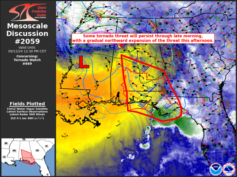
   Mesoscale Discussion 2059
   NWS Storm Prediction Center Norman OK
   1006 AM CDT Thu Sep 12 2024

   Areas affected...Parts of the FL Panhandle...south/central AL...far
   southwest GA

   Concerning...Tornado Watch 669...

   Valid 121506Z - 121730Z

   The severe weather threat for Tornado Watch 669 continues.

   SUMMARY...Some tornado threat will persist through late morning,
   with some northward expansion of the threat into this afternoon.

   DISCUSSION...Several supercells have moved onshore across parts of
   the FL Panhandle this morning, before tending to weaken as they move
   farther inland with time. Some weakening of low-level flow has been
   noted from the KEVX VWP, and this trend will continue from south to
   north through the day, as Tropical Depression Francine continues to
   move north-northeastward and weaken. However, low-level shear/SRH
   remains favorable for tornadoes with any sustained supercells, and
   the thermodynamic environment may become more favorable with time,
   as richer low-level moisture (with dewpoints in the mid 70s F)
   continues to gradually spread northward.

   Farther northwest, a pronounced midlevel dry slot is moving over
   south/central AL. This may allow for some diurnal heating across the
   region, though it also will tend to suppress deeper convection to
   some extent. Even if convection remains relatively shallow, a
   favorable overlap of modest buoyancy (with MLCAPE near 500 J/kg) and
   rather strong low-level shear/SRH attendant to Francine may support
   a threat of a couple tornadoes into this afternoon, with some
   northward expansion of the threat possible with time.

   With WW 669 expiring at 18Z, additional watch issuance is possible
   this afternoon.

   ..Dean/Guyer.. 09/12/2024

   ...Please see www.spc.noaa.gov for graphic product...

   ATTN...WFO...FFC...TAE...BMX...MOB...

   LAT...LON   30948741 31688761 32958781 32108507 31218461 30868437
               30428411 30018399 29648401 29468440 29368519 29608590
               29868678 29938733 30948741
|


 @NWSSPC