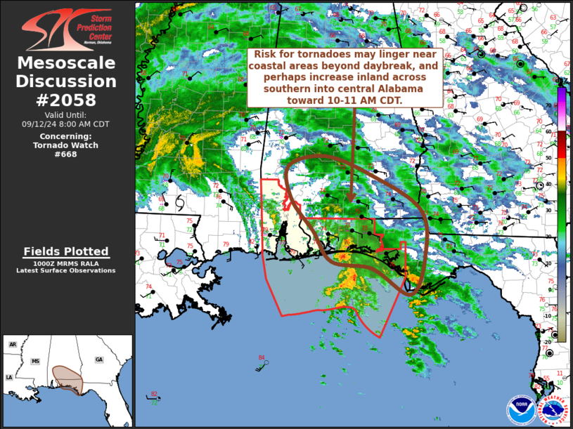
   Mesoscale Discussion 2058
   NWS Storm Prediction Center Norman OK
   0501 AM CDT Thu Sep 12 2024

   Areas affected...southern Alabama and the Florida Panhandle

   Concerning...Tornado Watch 668...

   Valid 121001Z - 121300Z

   The severe weather threat for Tornado Watch 668 continues.

   SUMMARY...A risk for showers and thunderstorms with potential to
   produce tornadoes may linger near coastal areas of the western
   Florida Panhandle beyond daybreak.  Farther inland this potential
   appears more limited, but could increase some across parts of
   southern into central Alabama toward 10-11 AM CDT.  A new Tornado
   Watch will be issued prior to expiration of Tornado Watch 668.

   DISCUSSION...The surface low associated with Francine is now
   progressing into south central Mississippi, near/southeast to east
   of McComb.  Based on the surface pressure fall/rise couplet evident
   in observational data, the center may gradually take on a more
   northerly to north-northwesterly track toward the Jackson vicinity
   into mid morning.  As this occurs, strongest low-level wind fields
   are forecast to continue shifting inland to the north and northeast
   of the circulation, generally above a residually stable
   boundary-layer air mass.  However, low-level hodographs continue to
   become enlarged and clockwise curved across and inland of the
   coastal western Florida Panhandle, and model forecast soundings
   suggest that these profiles, potentially conducive to convection
   with occasionally strengthening mesocyclones and a risk for
   tornadoes, may persist beyond daybreak.

   Complicating the tornadic potential, mid/upper 70s surface dew
   points have largely remained confined to the offshore waters,
   maintaining stable conditions inland of perhaps immediate coastal
   areas.  This may not change much into the 13-14Z time frame.
   Farther inland, at least some surface warming may increasingly begin
   to destabilize the boundary-layer northward through portions of
   south central Alabama by 15-16Z.  However, based on forecast
   soundings, it remains uncertain whether this will occur before
   low-level wind fields/hodographs become less conducive to tornadic
   potential, as Francine continues a northward track.

   ..Kerr.. 09/12/2024

   ...Please see www.spc.noaa.gov for graphic product...

   ATTN...WFO...TAE...BMX...MOB...

   LAT...LON   29598527 30088608 30218694 30778733 31348780 31948787
               32148708 31798609 31148504 30308497 29598527
|


 @NWSSPC