 Note:
The expiration time in the watch graphic is amended if the watch is
replaced, cancelled or extended.
Note:
Note:
The expiration time in the watch graphic is amended if the watch is
replaced, cancelled or extended.
Note: Click for
Watch Status Reports.
SEL7
URGENT - IMMEDIATE BROADCAST REQUESTED
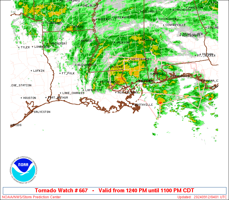
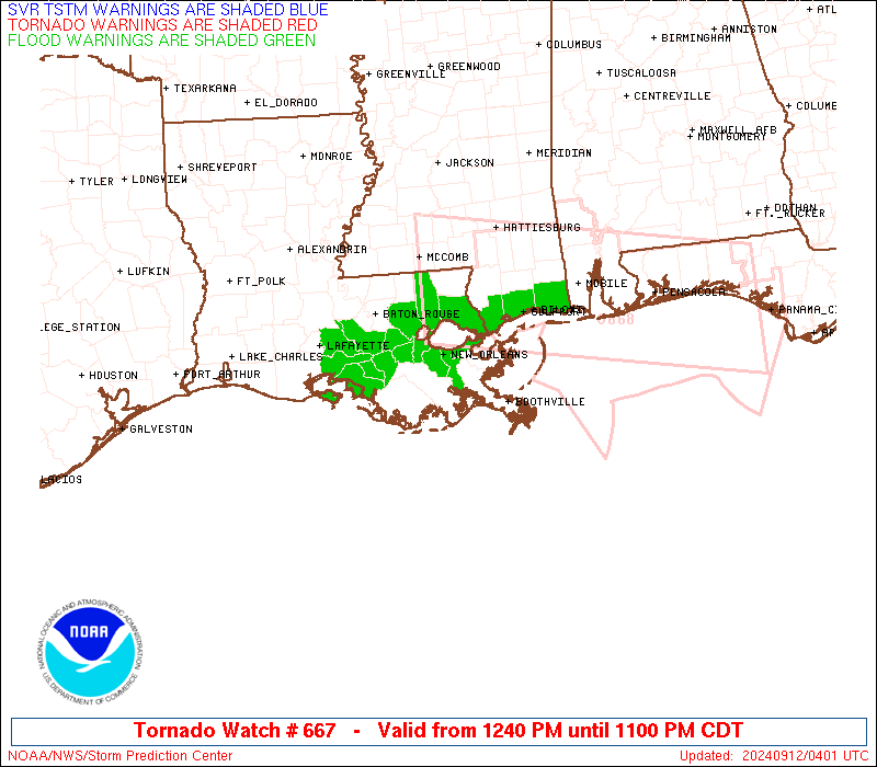
Tornado Watch Number 667
NWS Storm Prediction Center Norman OK
1240 PM CDT Wed Sep 11 2024
The NWS Storm Prediction Center has issued a
* Tornado Watch for portions of
Southern Louisiana
Far Southern Mississippi
Coastal Waters
* Effective this Wednesday afternoon and evening from 1240 PM
until 1100 PM CDT.
* Primary threats include...
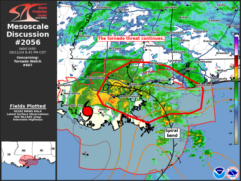
Several tornadoes likely
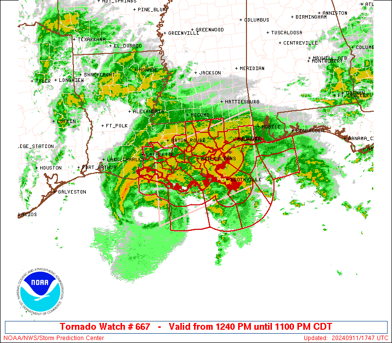
SUMMARY...Hurricane Francine will continue to approach the southern
Louisiana coast and move inland as it progresses northeastward
across the region through tonight. The potential for tornadoes is
expected to increase through the afternoon and early evening.
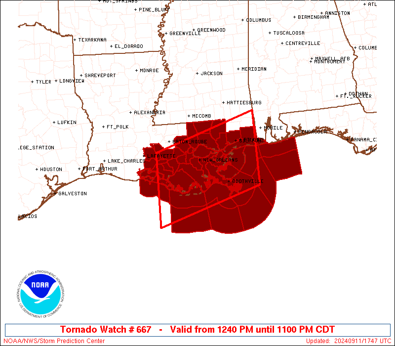
The tornado watch area is approximately along and 70 statute miles
north and south of a line from 60 miles west southwest of Houma LA
to 40 miles east southeast of Gulfport MS. For a complete depiction
of the watch see the associated watch outline update (WOUS64 KWNS
WOU7).
PRECAUTIONARY/PREPAREDNESS ACTIONS...
REMEMBER...A Tornado Watch means conditions are favorable for
tornadoes and severe thunderstorms in and close to the watch
area. Persons in these areas should be on the lookout for
threatening weather conditions and listen for later statements
and possible warnings.
&&
AVIATION...Tornadoes and a few severe thunderstorms with hail
surface and aloft to 0 inches. Extreme turbulence and surface wind
gusts to 60 knots. A few cumulonimbi with maximum tops to 500. Mean
storm motion vector 16045.
...Guyer
 Note:
The Aviation Watch (SAW) product is an approximation to the watch area.
The actual watch is depicted by the shaded areas.
Note:
The Aviation Watch (SAW) product is an approximation to the watch area.
The actual watch is depicted by the shaded areas.
   SAW7
   WW 667 TORNADO LA MS CW 111740Z - 120400Z
   AXIS..70 STATUTE MILES NORTH AND SOUTH OF LINE..
   60WSW HUM/HOUMA LA/ - 40ESE GPT/GULFPORT MS/
   ..AVIATION COORDS.. 60NM N/S /76SSW BTR - 34S SJI/
   WIND GUSTS..60 KNOTS.
   MAX TOPS TO 500.MEAN STORM MOTION VECTOR 16045.

   LAT...LON 30259159 31198845 29168845 28229159

   THIS IS AN APPROXIMATION TO THE WATCH AREA.  FOR A
   COMPLETE DEPICTION OF THE WATCH SEE WOUS64 KWNS
   FOR WOU7.
Watch 667 Status Report Messages:
STATUS REPORT #4 ON WW 667

VALID 120155Z - 120240Z

SEVERE WEATHER THREAT CONTINUES RIGHT OF A LINE FROM 105 SSE BVE
TO 45 ESE BVE TO 30 ENE BVE TO 30 ESE MSY TO 5 W MSY TO 25 W MSY
TO 50 WNW MSY TO 55 SW MCB.

..JEWELL..09/12/24

ATTN...WFO...LIX...LCH...MOB...

&&

STATUS REPORT FOR WT 667

SEVERE WEATHER THREAT CONTINUES FOR THE FOLLOWING AREAS

LAC063-071-087-095-103-105-117-120240-

LA
.    LOUISIANA PARISHES INCLUDED ARE

LIVINGSTON	     ORLEANS		 ST. BERNARD
ST. JOHN THE BAPTIST ST. TAMMANY	 TANGIPAHOA
WASHINGTON
$$


MSC045-047-059-109-120240-

MS
.    MISSISSIPPI COUNTIES INCLUDED ARE

HANCOCK 	     HARRISON		 JACKSON
PEARL RIVER
$$


GMZ530-532-534-536-538-555-557-575-577-632-650-670-120240-

CW

.    ADJACENT COASTAL WATERS INCLUDED ARE

LAKE PONTCHARTRAIN AND LAKE MAUREPAS

MISSISSIPPI SOUND

LAKE BORGNE

CHANDELEUR SOUND

BRETON SOUND

COASTAL WATERS FROM BOOTHVILLE LA TO SOUTHWEST PASS OF THE
MISSISSIPPI RIVER OUT 20 NM

COASTAL WATERS FROM PASCAGOULA MISSISSIPPI TO STAKE ISLAND OUT 20
NM

COASTAL WATERS FROM STAKE ISLAND LA TO SOUTHWEST PASS OF THE
MISSISSIPPI RIVER FROM 20 TO 60 NM

COASTAL WATERS FROM PASCAGOULA MISSISSIPPI TO STAKE ISLAND
LOUISIANA OUT 20 TO 60 NM

MISSISSIPPI SOUND

COASTAL WATERS FROM PENSACOLA FL TO PASCAGOULA MS OUT 20 NM

WATERS FROM PENSACOLA FL TO PASCAGOULA MS FROM 20 TO 60 NM

$$
THE WATCH STATUS MESSAGE IS FOR GUIDANCE PURPOSES ONLY.  PLEASE
REFER TO WATCH COUNTY NOTIFICATION STATEMENTS FOR OFFICIAL
INFORMATION ON COUNTIES...INDEPENDENT CITIES AND MARINE ZONES
CLEARED FROM SEVERE THUNDERSTORM AND TORNADO WATCHES.
$$

STATUS REPORT #3 ON WW 667

VALID 112300Z - 120040Z

SEVERE WEATHER THREAT CONTINUES RIGHT OF A LINE FROM 110 S BVE TO
50 S BVE TO 15 SSW BVE TO 20 W BVE TO 30 E HUM TO 5 NE HUM TO 20
WNW HUM TO 40 WNW HUM TO 45 NW HUM TO 50 SW MCB.

..JEWELL..09/11/24

ATTN...WFO...LIX...LCH...MOB...

&&

STATUS REPORT FOR WT 667

SEVERE WEATHER THREAT CONTINUES FOR THE FOLLOWING AREAS

LAC005-007-047-051-057-063-071-075-087-089-093-095-103-105-117-
120040-

LA
.    LOUISIANA PARISHES INCLUDED ARE

ASCENSION	     ASSUMPTION 	 IBERVILLE
JEFFERSON	     LAFOURCHE		 LIVINGSTON
ORLEANS 	     PLAQUEMINES	 ST. BERNARD
ST. CHARLES	     ST. JAMES		 ST. JOHN THE BAPTIST
ST. TAMMANY	     TANGIPAHOA 	 WASHINGTON
$$


MSC045-047-059-109-120040-

MS
.    MISSISSIPPI COUNTIES INCLUDED ARE

HANCOCK 	     HARRISON		 JACKSON
PEARL RIVER
$$


GMZ530-532-534-536-538-555-557-575-577-632-650-670-120040-

CW

.    ADJACENT COASTAL WATERS INCLUDED ARE

LAKE PONTCHARTRAIN AND LAKE MAUREPAS

MISSISSIPPI SOUND

LAKE BORGNE

CHANDELEUR SOUND

BRETON SOUND

COASTAL WATERS FROM BOOTHVILLE LA TO SOUTHWEST PASS OF THE
MISSISSIPPI RIVER OUT 20 NM

COASTAL WATERS FROM PASCAGOULA MISSISSIPPI TO STAKE ISLAND OUT 20
NM

COASTAL WATERS FROM STAKE ISLAND LA TO SOUTHWEST PASS OF THE
MISSISSIPPI RIVER FROM 20 TO 60 NM

COASTAL WATERS FROM PASCAGOULA MISSISSIPPI TO STAKE ISLAND
LOUISIANA OUT 20 TO 60 NM

MISSISSIPPI SOUND

COASTAL WATERS FROM PENSACOLA FL TO PASCAGOULA MS OUT 20 NM

WATERS FROM PENSACOLA FL TO PASCAGOULA MS FROM 20 TO 60 NM

$$
THE WATCH STATUS MESSAGE IS FOR GUIDANCE PURPOSES ONLY.  PLEASE
REFER TO WATCH COUNTY NOTIFICATION STATEMENTS FOR OFFICIAL
INFORMATION ON COUNTIES...INDEPENDENT CITIES AND MARINE ZONES
CLEARED FROM SEVERE THUNDERSTORM AND TORNADO WATCHES.
$$

STATUS REPORT #2 ON WW 667

VALID 112055Z - 112140Z

THE SEVERE WEATHER THREAT CONTINUES ACROSS THE ENTIRE WATCH AREA.

..SQUITIERI..09/11/24

ATTN...WFO...LIX...LCH...MOB...

&&

STATUS REPORT FOR WT 667

SEVERE WEATHER THREAT CONTINUES FOR THE FOLLOWING AREAS

LAC005-007-045-047-051-057-063-071-075-087-089-093-095-099-101-
103-105-109-117-112140-

LA
.    LOUISIANA PARISHES INCLUDED ARE

ASCENSION	     ASSUMPTION 	 IBERIA
IBERVILLE	     JEFFERSON		 LAFOURCHE
LIVINGSTON	     ORLEANS		 PLAQUEMINES
ST. BERNARD	     ST. CHARLES	 ST. JAMES
ST. JOHN THE BAPTIST ST. MARTIN 	 ST. MARY
ST. TAMMANY	     TANGIPAHOA 	 TERREBONNE
WASHINGTON
$$


MSC045-047-059-109-112140-

MS
.    MISSISSIPPI COUNTIES INCLUDED ARE

HANCOCK 	     HARRISON		 JACKSON
PEARL RIVER
$$


GMZ435-436-455-530-532-534-536-538-550-552-555-557-570-572-575-
577-632-650-670-112140-

CW

.    ADJACENT COASTAL WATERS INCLUDED ARE

VERMILION BAY


COASTAL WATERS FROM LOWER ATCHAFALAYA RIVER TO INTRACOASTAL CITY
LA OUT 20 NM

LAKE PONTCHARTRAIN AND LAKE MAUREPAS

MISSISSIPPI SOUND

LAKE BORGNE

CHANDELEUR SOUND

BRETON SOUND

COASTAL WATERS FROM PORT FOURCHON LA TO LOWER ATCHAFALAYA RIVER
LA OUT 20 NM

COASTAL WATERS FROM THE SOUTHWEST PASS OF THE MISSISSIPPI RIVER
TO PORT FOURCHON LOUISIANA OUT 20 NM

COASTAL WATERS FROM BOOTHVILLE LA TO SOUTHWEST PASS OF THE
MISSISSIPPI RIVER OUT 20 NM

COASTAL WATERS FROM PASCAGOULA MISSISSIPPI TO STAKE ISLAND OUT 20
NM

COASTAL WATERS FROM PORT FOURCHON LOUISIANA TO LOWER ATCHAFALAYA
RIVER LA FROM 20 TO 60 NM

COASTAL WATERS FROM SOUTHWEST PASS OF THE MISSISSIPPI RIVER TO
PORT FOURCHON LOUISIANA FROM 20 TO 60 NM

COASTAL WATERS FROM STAKE ISLAND LA TO SOUTHWEST PASS OF THE
MISSISSIPPI RIVER FROM 20 TO 60 NM

COASTAL WATERS FROM PASCAGOULA MISSISSIPPI TO STAKE ISLAND
LOUISIANA OUT 20 TO 60 NM

MISSISSIPPI SOUND

COASTAL WATERS FROM PENSACOLA FL TO PASCAGOULA MS OUT 20 NM

WATERS FROM PENSACOLA FL TO PASCAGOULA MS FROM 20 TO 60 NM

$$
THE WATCH STATUS MESSAGE IS FOR GUIDANCE PURPOSES ONLY.  PLEASE
REFER TO WATCH COUNTY NOTIFICATION STATEMENTS FOR OFFICIAL
INFORMATION ON COUNTIES...INDEPENDENT CITIES AND MARINE ZONES
CLEARED FROM SEVERE THUNDERSTORM AND TORNADO WATCHES.
$$

STATUS REPORT #1 ON WW 667

VALID 111900Z - 112040Z

THE SEVERE WEATHER THREAT CONTINUES ACROSS THE ENTIRE WATCH AREA.

..SQUITIERI..09/11/24

ATTN...WFO...LIX...LCH...MOB...

&&

STATUS REPORT FOR WT 667

SEVERE WEATHER THREAT CONTINUES FOR THE FOLLOWING AREAS

LAC005-007-045-047-051-057-063-071-075-087-089-093-095-099-101-
103-105-109-117-112040-

LA
.    LOUISIANA PARISHES INCLUDED ARE

ASCENSION	     ASSUMPTION 	 IBERIA
IBERVILLE	     JEFFERSON		 LAFOURCHE
LIVINGSTON	     ORLEANS		 PLAQUEMINES
ST. BERNARD	     ST. CHARLES	 ST. JAMES
ST. JOHN THE BAPTIST ST. MARTIN 	 ST. MARY
ST. TAMMANY	     TANGIPAHOA 	 TERREBONNE
WASHINGTON
$$


MSC045-047-059-109-112040-

MS
.    MISSISSIPPI COUNTIES INCLUDED ARE

HANCOCK 	     HARRISON		 JACKSON
PEARL RIVER
$$


GMZ435-436-455-530-532-534-536-538-550-552-555-557-570-572-575-
577-632-650-670-112040-

CW

.    ADJACENT COASTAL WATERS INCLUDED ARE

VERMILION BAY


COASTAL WATERS FROM LOWER ATCHAFALAYA RIVER TO INTRACOASTAL CITY
LA OUT 20 NM

LAKE PONTCHARTRAIN AND LAKE MAUREPAS

MISSISSIPPI SOUND

LAKE BORGNE

CHANDELEUR SOUND

BRETON SOUND

COASTAL WATERS FROM PORT FOURCHON LA TO LOWER ATCHAFALAYA RIVER
LA OUT 20 NM

COASTAL WATERS FROM THE SOUTHWEST PASS OF THE MISSISSIPPI RIVER
TO PORT FOURCHON LOUISIANA OUT 20 NM

COASTAL WATERS FROM BOOTHVILLE LA TO SOUTHWEST PASS OF THE
MISSISSIPPI RIVER OUT 20 NM

COASTAL WATERS FROM PASCAGOULA MISSISSIPPI TO STAKE ISLAND OUT 20
NM

COASTAL WATERS FROM PORT FOURCHON LOUISIANA TO LOWER ATCHAFALAYA
RIVER LA FROM 20 TO 60 NM

COASTAL WATERS FROM SOUTHWEST PASS OF THE MISSISSIPPI RIVER TO
PORT FOURCHON LOUISIANA FROM 20 TO 60 NM

COASTAL WATERS FROM STAKE ISLAND LA TO SOUTHWEST PASS OF THE
MISSISSIPPI RIVER FROM 20 TO 60 NM

COASTAL WATERS FROM PASCAGOULA MISSISSIPPI TO STAKE ISLAND
LOUISIANA OUT 20 TO 60 NM

MISSISSIPPI SOUND

COASTAL WATERS FROM PENSACOLA FL TO PASCAGOULA MS OUT 20 NM

WATERS FROM PENSACOLA FL TO PASCAGOULA MS FROM 20 TO 60 NM

$$
THE WATCH STATUS MESSAGE IS FOR GUIDANCE PURPOSES ONLY.  PLEASE
REFER TO WATCH COUNTY NOTIFICATION STATEMENTS FOR OFFICIAL
INFORMATION ON COUNTIES...INDEPENDENT CITIES AND MARINE ZONES
CLEARED FROM SEVERE THUNDERSTORM AND TORNADO WATCHES.
$$
Note:
Click for Complete Product Text.
Tornadoes
Probability of 2 or more tornadoes
|
High (80%)
|
Probability of 1 or more strong (EF2-EF5) tornadoes
|
Low (20%)
|
Wind
Probability of 10 or more severe wind events
|
Low (<5%)
|
Probability of 1 or more wind events > 65 knots
|
Low (<5%)
|
Hail
Probability of 10 or more severe hail events
|
Low (<5%)
|
Probability of 1 or more hailstones > 2 inches
|
Low (<5%)
|
Combined Severe Hail/Wind
Probability of 6 or more combined severe hail/wind events
|
Low (20%)
|
For each watch, probabilities for particular events inside the watch
(listed above in each table) are determined by the issuing forecaster.
The "Low" category contains probability values ranging from less than 2%
to 20% (EF2-EF5 tornadoes), less than 5% to 20% (all other probabilities),
"Moderate" from 30% to 60%, and "High" from 70% to greater than 95%.
High values are bolded and lighter in color to provide awareness of
an increased threat for a particular event.


 @NWSSPC