Note:
The expiration time in the watch graphic is amended if the watch is
replaced, cancelled or extended.
Note:
Note:
The expiration time in the watch graphic is amended if the watch is
replaced, cancelled or extended.
Note: Click for
Watch Status Reports.
SEL6
URGENT - IMMEDIATE BROADCAST REQUESTED
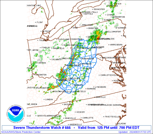
Severe Thunderstorm Watch Number 666
NWS Storm Prediction Center Norman OK
125 PM EDT Sat Aug 31 2024
The NWS Storm Prediction Center has issued a
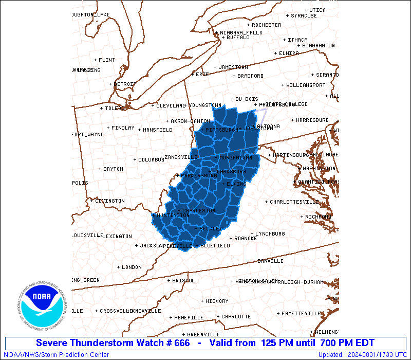
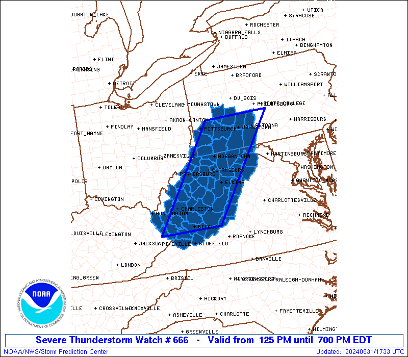
* Severe Thunderstorm Watch for portions of
Western Maryland
Southwest Pennsylvania
Northwest Virginia
West Virginia
* Effective this Saturday afternoon and evening from 125 PM until
700 PM EDT.
* Primary threats include...
Scattered damaging wind gusts to 70 mph possible
Isolated large hail events to 1.5 inches in diameter possible
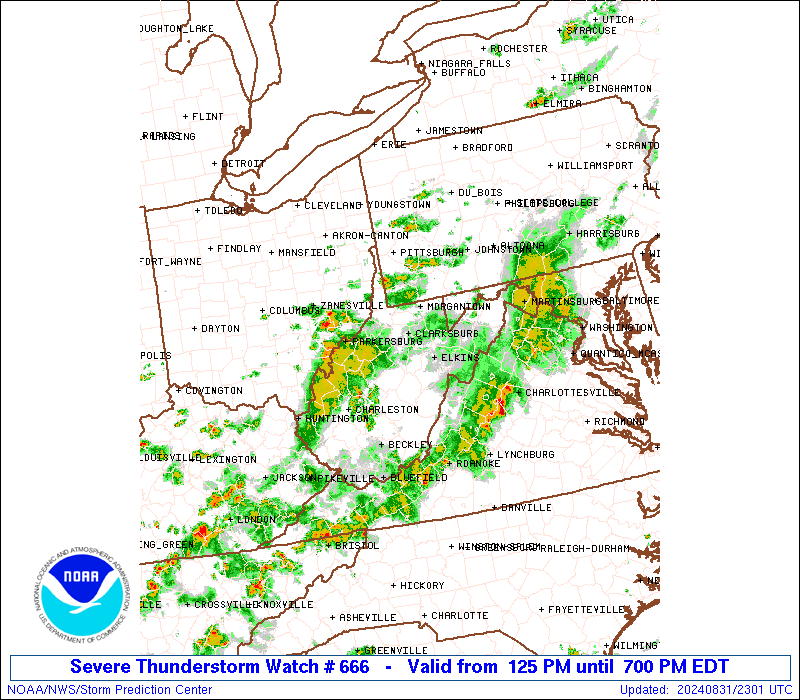
SUMMARY...Thunderstorms are expected to increase in coverage and
move east across the watch area through the afternoon, posing a risk
for scattered damaging wind gusts and isolated instances of large
hail.
The severe thunderstorm watch area is approximately along and 60
statute miles east and west of a line from 40 miles northwest of
Altoona PA to 10 miles southwest of Beckley WV. For a complete
depiction of the watch see the associated watch outline update
(WOUS64 KWNS WOU6).
PRECAUTIONARY/PREPAREDNESS ACTIONS...
REMEMBER...A Severe Thunderstorm Watch means conditions are
favorable for severe thunderstorms in and close to the watch area.
Persons in these areas should be on the lookout for threatening
weather conditions and listen for later statements and possible
warnings. Severe thunderstorms can and occasionally do produce
tornadoes.
&&
AVIATION...A few severe thunderstorms with hail surface and aloft to
1.5 inches. Extreme turbulence and surface wind gusts to 60 knots. A
few cumulonimbi with maximum tops to 550. Mean storm motion vector
26025.
...Bunting
   SEL6

   URGENT - IMMEDIATE BROADCAST REQUESTED
   Severe Thunderstorm Watch Number 666
   NWS Storm Prediction Center Norman OK
   125 PM EDT Sat Aug 31 2024

   The NWS Storm Prediction Center has issued a

   * Severe Thunderstorm Watch for portions of
     Western Maryland
     Southwest Pennsylvania
     Northwest Virginia
     West Virginia

   * Effective this Saturday afternoon and evening from 125 PM until
     700 PM EDT.

   * Primary threats include...
     Scattered damaging wind gusts to 70 mph possible
     Isolated large hail events to 1.5 inches in diameter possible

   SUMMARY...Thunderstorms are expected to increase in coverage and
   move east across the watch area through the afternoon, posing a risk
   for scattered damaging wind gusts and isolated instances of large
   hail.

   The severe thunderstorm watch area is approximately along and 60
   statute miles east and west of a line from 40 miles northwest of
   Altoona PA to 10 miles southwest of Beckley WV. For a complete
   depiction of the watch see the associated watch outline update
   (WOUS64 KWNS WOU6).

   PRECAUTIONARY/PREPAREDNESS ACTIONS...

   REMEMBER...A Severe Thunderstorm Watch means conditions are
   favorable for severe thunderstorms in and close to the watch area.
   Persons in these areas should be on the lookout for threatening
   weather conditions and listen for later statements and possible
   warnings. Severe thunderstorms can and occasionally do produce
   tornadoes.

   &&

   AVIATION...A few severe thunderstorms with hail surface and aloft to
   1.5 inches. Extreme turbulence and surface wind gusts to 60 knots. A
   few cumulonimbi with maximum tops to 550. Mean storm motion vector
   26025.

   ...Bunting
 Note:
The Aviation Watch (SAW) product is an approximation to the watch area.
The actual watch is depicted by the shaded areas.
Note:
The Aviation Watch (SAW) product is an approximation to the watch area.
The actual watch is depicted by the shaded areas.
   SAW6
   WW 666 SEVERE TSTM MD PA VA WV 311725Z - 312300Z
   AXIS..60 STATUTE MILES EAST AND WEST OF LINE..
   40NW AOO/ALTOONA PA/ - 10SW BKW/BECKLEY WV/
   ..AVIATION COORDS.. 50NM E/W /23N JST - 9SW BKW/
   HAIL SURFACE AND ALOFT..1.5 INCHES. WIND GUSTS..60 KNOTS.
   MAX TOPS TO 550. MEAN STORM MOTION VECTOR 26025.

   LAT...LON 40687769 37668015 37668235 40688000

   THIS IS AN APPROXIMATION TO THE WATCH AREA.  FOR A
   COMPLETE DEPICTION OF THE WATCH SEE WOUS64 KWNS
   FOR WOU6.
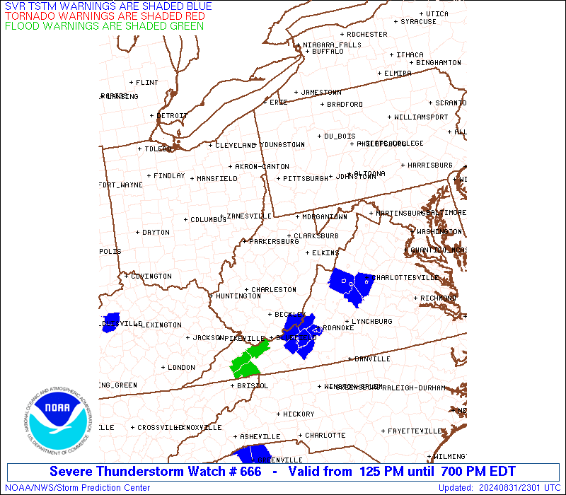
Watch 666 Status Report Messages:
STATUS REPORT #3 ON WW 666
VALID 312145Z - 312240Z
SEVERE WEATHER THREAT CONTINUES RIGHT OF A LINE FROM 5 NNW PKB TO
30 N SHD TO 20 NW HGR.
..MOORE..08/31/24
ATTN...WFO...LWX...PBZ...CTP...RNK...RLX...
&&
STATUS REPORT FOR WS 666
SEVERE WEATHER THREAT CONTINUES FOR THE FOLLOWING AREAS
MDC043-312240-
MD
. MARYLAND COUNTIES INCLUDED ARE
WASHINGTON
$$
VAC005-017-019-023-043-045-067-069-091-139-163-165-171-187-530-
580-660-678-770-775-790-820-840-312240-
VA
. VIRGINIA COUNTIES INCLUDED ARE
ALLEGHANY BATH BEDFORD
BOTETOURT CLARKE CRAIG
FRANKLIN FREDERICK HIGHLAND
PAGE ROCKBRIDGE ROCKINGHAM
SHENANDOAH WARREN
VIRGINIA INDEPENDENT CITIES INCLUDED ARE
BUENA VISTA COVINGTON HARRISONBURG
LEXINGTON ROANOKE SALEM
STAUNTON WAYNESBORO WINCHESTER
$$
WVC003-005-007-013-015-019-021-025-035-037-039-041-043-045-047-
055-059-063-067-071-075-079-081-083-085-087-089-097-099-101-105-
109-312240-
WV
. WEST VIRGINIA COUNTIES INCLUDED ARE
BERKELEY BOONE BRAXTON
CALHOUN CLAY FAYETTE
GILMER GREENBRIER JACKSON
JEFFERSON KANAWHA LEWIS
LINCOLN LOGAN MCDOWELL
MERCER MINGO MONROE
NICHOLAS PENDLETON POCAHONTAS
PUTNAM RALEIGH RANDOLPH
RITCHIE ROANE SUMMERS
UPSHUR WAYNE WEBSTER
WIRT WYOMING
$$
THE WATCH STATUS MESSAGE IS FOR GUIDANCE PURPOSES ONLY. PLEASE
REFER TO WATCH COUNTY NOTIFICATION STATEMENTS FOR OFFICIAL
INFORMATION ON COUNTIES...INDEPENDENT CITIES AND MARINE ZONES
CLEARED FROM SEVERE THUNDERSTORM AND TORNADO WATCHES.
$$
STATUS REPORT #2 ON WW 666
VALID 312050Z - 312140Z
SEVERE WEATHER THREAT CONTINUES RIGHT OF A LINE FROM 10 W HLG TO
20 N MGW TO 20 SE MGW TO 45 ESE MGW TO 25 SSE AOO AND 10 N PIT TO
30 ENE LBE TO 20 ESE UNV.
..WENDT..08/31/24
ATTN...WFO...LWX...PBZ...CTP...RNK...RLX...
&&
STATUS REPORT FOR WS 666
SEVERE WEATHER THREAT CONTINUES FOR THE FOLLOWING AREAS
MDC001-043-312140-
MD
. MARYLAND COUNTIES INCLUDED ARE
ALLEGANY WASHINGTON
$$
PAC059-312140-
PA
. PENNSYLVANIA COUNTIES INCLUDED ARE
GREENE
$$
VAC005-017-043-069-091-139-165-171-187-580-660-790-820-840-
312140-
VA
. VIRGINIA COUNTIES INCLUDED ARE
ALLEGHANY BATH CLARKE
FREDERICK HIGHLAND PAGE
ROCKINGHAM SHENANDOAH WARREN
VIRGINIA INDEPENDENT CITIES INCLUDED ARE
COVINGTON HARRISONBURG STAUNTON
WAYNESBORO WINCHESTER
$$
WVC001-003-005-007-013-015-017-019-021-023-025-027-031-033-035-
037-039-041-043-045-047-049-051-055-057-059-061-063-065-067-071-
073-075-077-079-081-083-085-087-089-091-093-095-097-099-101-103-
105-109-312140-
WV
. WEST VIRGINIA COUNTIES INCLUDED ARE
BARBOUR BERKELEY BOONE
BRAXTON CALHOUN CLAY
DODDRIDGE FAYETTE GILMER
GRANT GREENBRIER HAMPSHIRE
HARDY HARRISON JACKSON
JEFFERSON KANAWHA LEWIS
LINCOLN LOGAN MCDOWELL
MARION MARSHALL MERCER
MINERAL MINGO MONONGALIA
MONROE MORGAN NICHOLAS
PENDLETON PLEASANTS POCAHONTAS
PRESTON PUTNAM RALEIGH
RANDOLPH RITCHIE ROANE
SUMMERS TAYLOR TUCKER
TYLER UPSHUR WAYNE
WEBSTER WETZEL WIRT
WYOMING
$$
THE WATCH STATUS MESSAGE IS FOR GUIDANCE PURPOSES ONLY. PLEASE
REFER TO WATCH COUNTY NOTIFICATION STATEMENTS FOR OFFICIAL
INFORMATION ON COUNTIES...INDEPENDENT CITIES AND MARINE ZONES
CLEARED FROM SEVERE THUNDERSTORM AND TORNADO WATCHES.
$$
STATUS REPORT #1 ON WW 666
VALID 311945Z - 312040Z
SEVERE WEATHER THREAT CONTINUES RIGHT OF A LINE FROM 10 N PIT TO
30 ENE LBE TO 20 ESE UNV.
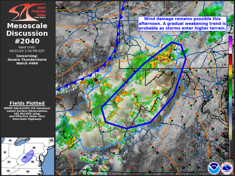
FOR ADDITIONAL INFORMATION SEE MESOSCALE DISCUSSION 2040
..WENDT..08/31/24
ATTN...WFO...LWX...PBZ...CTP...RNK...RLX...
&&
STATUS REPORT FOR WS 666
SEVERE WEATHER THREAT CONTINUES FOR THE FOLLOWING AREAS
MDC001-023-312040-
MD
. MARYLAND COUNTIES INCLUDED ARE
ALLEGANY GARRETT
$$
PAC003-009-013-051-059-111-125-129-312040-
PA
. PENNSYLVANIA COUNTIES INCLUDED ARE
ALLEGHENY BEDFORD BLAIR
FAYETTE GREENE SOMERSET
WASHINGTON WESTMORELAND
$$
VAC005-017-043-069-091-139-165-171-187-580-660-790-820-840-
312040-
VA
. VIRGINIA COUNTIES INCLUDED ARE
ALLEGHANY BATH CLARKE
FREDERICK HIGHLAND PAGE
ROCKINGHAM SHENANDOAH WARREN
VIRGINIA INDEPENDENT CITIES INCLUDED ARE
COVINGTON HARRISONBURG STAUNTON
WAYNESBORO WINCHESTER
$$
WVC001-005-007-013-015-017-019-021-023-025-027-031-033-035-039-
041-043-045-047-049-051-055-057-059-061-063-065-067-071-073-075-
077-079-081-083-085-087-089-091-093-095-097-099-101-103-105-109-
312040-
WV
. WEST VIRGINIA COUNTIES INCLUDED ARE
BARBOUR BOONE BRAXTON
CALHOUN CLAY DODDRIDGE
FAYETTE GILMER GRANT
GREENBRIER HAMPSHIRE HARDY
HARRISON JACKSON KANAWHA
LEWIS LINCOLN LOGAN
MCDOWELL MARION MARSHALL
MERCER MINERAL MINGO
MONONGALIA MONROE MORGAN
NICHOLAS PENDLETON PLEASANTS
POCAHONTAS PRESTON PUTNAM
RALEIGH RANDOLPH RITCHIE
ROANE SUMMERS TAYLOR
TUCKER TYLER UPSHUR
WAYNE WEBSTER WETZEL
WIRT WYOMING
$$
THE WATCH STATUS MESSAGE IS FOR GUIDANCE PURPOSES ONLY. PLEASE
REFER TO WATCH COUNTY NOTIFICATION STATEMENTS FOR OFFICIAL
INFORMATION ON COUNTIES...INDEPENDENT CITIES AND MARINE ZONES
CLEARED FROM SEVERE THUNDERSTORM AND TORNADO WATCHES.
$$
Note:
Click for Complete Product Text.
Tornadoes
Probability of 2 or more tornadoes
|
Low (<5%)
|
Probability of 1 or more strong (EF2-EF5) tornadoes
|
Low (<2%)
|
Wind
Probability of 10 or more severe wind events
|
Mod (40%)
|
Probability of 1 or more wind events > 65 knots
|
Low (20%)
|
Hail
Probability of 10 or more severe hail events
|
Low (20%)
|
Probability of 1 or more hailstones > 2 inches
|
Low (10%)
|
Combined Severe Hail/Wind
Probability of 6 or more combined severe hail/wind events
|
Mod (60%)
|
For each watch, probabilities for particular events inside the watch
(listed above in each table) are determined by the issuing forecaster.
The "Low" category contains probability values ranging from less than 2%
to 20% (EF2-EF5 tornadoes), less than 5% to 20% (all other probabilities),
"Moderate" from 30% to 60%, and "High" from 70% to greater than 95%.
High values are bolded and lighter in color to provide awareness of
an increased threat for a particular event.


 @NWSSPC