|
| Mesoscale Discussion 2056 |
|
< Previous MD Next MD >
|
|
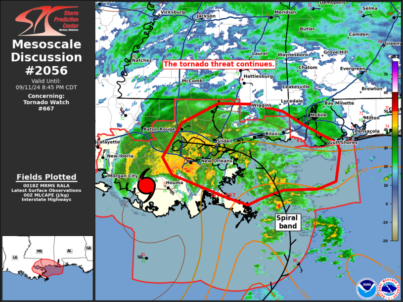
   Mesoscale Discussion 2056
   NWS Storm Prediction Center Norman OK
   0720 PM CDT Wed Sep 11 2024

   Areas affected...portions of southeastern Louisiana...far southern
   Mississippi and southwest Alabama

   Concerning...Tornado Watch 667...

   Valid 120020Z - 120145Z

   The severe weather threat for Tornado Watch 667 continues.

   SUMMARY...The tornado threat continues over the northeastern
   quadrant of Francine. While storms have not been overly active so
   far, strong low-level shear remains in place and a greater threat
   could evolve tonight.

   DISCUSSION...As of 0015z, the center of Hurricane Francine was
   located 55 miles southwest of New Orleans, LA. Within the
   northeastern quadrant, low-level hodographs have continued to
   enlarge this evening with the HDC VAD showing 500-600 m2/s2 of 0-1km
   SRH. While low-level shear remains very strong, east/northeasterly
   surface flow has prevented the more unstable air mass farther south
   from moving inland to this point. As the center of Francine
   continues to move inland, low-level flow should begin to veer,
   allowing the higher theta-E air mass to move onshore. This looks
   most likely to occur over eastern portions of WW667 into southern MS
   and far southwest AL later this evening. Convective cells within the
   eastern most spiral bands have shown more cellular mode and
   occasional rotation. Hi-res guidance shows a few of these supercells
   potentially moving inland tonight. Ahead of these storms, RAP
   soundings show enlarging hodographs and modest buoyancy (~500-700
   J/kg of MLCAPE) that could support the potential for a few tornadoes
   this evening.

   ..Lyons.. 09/12/2024

   ...Please see www.spc.noaa.gov for graphic product...

   ATTN...WFO...MOB...JAN...LIX...

   LAT...LON   30608816 30298753 30158747 29678755 29548789 29538851
               29418889 29308918 29418958 29779059 30059076 30439054
               30629042 30938974 30928909 30818852 30608816
|
|
Top/All Mesoscale Discussions/Forecast Products/Home
|
|


 @NWSSPC